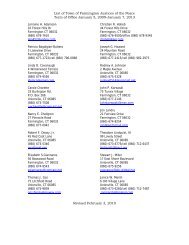
Condo Complexes - Town of Farmington
Condo Complexes - Town of Farmington
Condo Complexes - Town of Farmington

You also want an ePaper? Increase the reach of your titles
YUMPU automatically turns print PDFs into web optimized ePapers that Google loves.
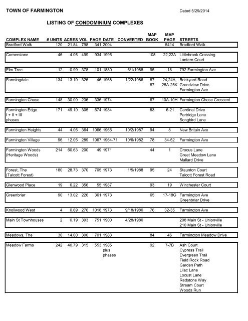
TOWN OF FARMINGTON Dated 5/29/2014<br />
LISTING OF CONDOMINIUM COMPLEXES<br />
MAP MAP<br />
COMPLEX NAME # UNITS ACRES VOL PAGE DATE CONVERTED BOOK PAGE STREETS<br />
Bradford Walk 120 21.84 798 341 2004 5414 Bradford Walk<br />
Cornerstone 46 4.05 499 934 1995 108 22,22A Littlebrook Crossing<br />
Lantern Court<br />
Elm Tree 12 0.99 378 101 1880 6/1/1988 95 18 792 <strong>Farmington</strong> Ave<br />
Farmingdale 134 13.10 326 46 1968 1/22/1986 87 24,24A, Brickyard Road<br />
87 25A-25K Grandview Drive<br />
<strong>Farmington</strong> Ave<br />
<strong>Farmington</strong> Chase 148 30.00 236 336 1974 67 10A-10H <strong>Farmington</strong> Chase Crescent<br />
<strong>Farmington</strong> Edge 171 49.10 305 674 1984 83 6-21 Cardinal Drive<br />
I + II + III<br />
Partridge Lane<br />
phases<br />
Songbird Lane<br />
<strong>Farmington</strong> Heights 44 4.06 364 1066 1966 10/2/1987 94 8 New Britain Ave<br />
<strong>Farmington</strong> Village 96 12.05 289 1067 1964-71 10/6/1982 78 34-52 <strong>Farmington</strong> Ave<br />
<strong>Farmington</strong> Woods 214 60.63 200 49 1971 44 1 Crocus Lane<br />
(Heritage Woods)<br />
Great Meadow Lane<br />
Mallard Drive<br />
Forest, The 180 28.73 370 705 1973 1/5/1988 95 24 Staunton Court<br />
(Talcott Forest)<br />
Talcott Forest Road<br />
Glenwood Place 19 6.22 356 55 1987 93 19 Winchester Court<br />
Greenbriar 90 13.02 226 361 1973 65 17-18G <strong>Farmington</strong> Ave<br />
Greenbriar Drive<br />
Knollwood West 4 0.69 276 1018 1973 9/18/1980 76 32-35 <strong>Farmington</strong> Ave<br />
Main St <strong>Town</strong>houses 2 0.19 393 751 1900 4/28/1980 208 Main St - Unionville<br />
210 Main St - Unionville<br />
Meadows, The 30 14.00 300 701 1983 84 46 <strong>Farmington</strong> Meadow Drive<br />
Meadow Farms 242 40.79 315 553 1985 92 7-7B Ash Court<br />
plus<br />
Cypress Trail<br />
phases<br />
Evergreen Trail<br />
Field Rock Road<br />
Garden Path<br />
Lilac Lane<br />
Locust Lane<br />
Redstone Way<br />
Stream Court<br />
Woods Run
MAP MAP<br />
COMPLEX NAME # UNITS ACRES VOL PAGE DATE CONVERTED BOOK PAGE STREETS<br />
Mountain Rd 2 0.549 883 404 8/18/2006 5607 75 Mountain Rd<br />
77 Mountain Rd<br />
Old Mountain Village 43 4.85 407 1 1988,93,94 105 59 Timberline Drive<br />
Perry St 2 0.28 797 101 5280 152 Perry St.<br />
154 Perry St.<br />
Red Oak 35 29.67 273 170 1979 75 17-29 Farm Drive<br />
Ridge, The 101 13.73 353 508 1970 92 1 Earls Court<br />
(Talcott Ridge)<br />
Staunton Court<br />
Talcott Ridge Road<br />
Rivercrest 12 5.40 365 642 1987 94 19-19F New Britain Ave<br />
River Oak 4 0.59 886 774 9/27/2006 5618 New Britain Ave<br />
River Park 12 2.066 831 206 5847 <strong>Farmington</strong> Ave<br />
Riverside 20 3.12 358 860 1986 92 27 New Britain Ave<br />
Riverview 6 2.05 272 607 1971 11/26/1979 75 9-11 New Britain Ave<br />
Snowberry Cobble 94 10.38 799 351 5485 Acorn Lane<br />
Arrowhead Dr<br />
Aztec Trail<br />
Country Rd<br />
Finch Blvd<br />
Holly Lane<br />
Sable Court<br />
Wildcat Drive<br />
Southwest Village 84 15.74 484 352 1990 114 29-29C Florence Way<br />
Talcott Village 137 19.04 207 1 1971 46 23-42A Byrne Court<br />
(The Glen)<br />
Lyle Court<br />
Talcott Glen Road<br />
Tunxis Village 95 20.85 270 685 1973 9/20/1979 74 24-31 Tunxis Village<br />
Tunxis Village 66 12.65 303 124 1984 CAB/MAP-> 65 4594 Tunxis Village<br />
Plantation II<br />
Union Place 4 0.77 371 823 1988 96 9-9C New Britain Ave<br />
Village <strong>Condo</strong>s 15 2.10 207 482 1971 CAB/MAP-> 47 2941 Garden Street<br />
Wellington 140 32.13 268 471 1979 1979 71 21A-21C Wellington Drive<br />
Society House 2 0.27 1014 32 1816 8/4/2011 map 5875 13 Church St. Unit #1<br />
map 5876 13 Church St. Unit #2
LISTING OF EXCLUSIVE USE COMPLEXES<br />
MAP<br />
COMPLEX NAME # UNITS ACRES VOL PAGE DATE CONVERTED CAB MAP STREETS<br />
Autumn Estates 30 16.30 2007 5616 Autumn Way<br />
Active Adult max #<br />
Hazelnut Dr<br />
October Glory<br />
Weeping Willow Court<br />
Chimney Hill 44 35.40 889 341 2006 5627 Chimney Hill Dr<br />
Active Adult max #<br />
Hearthstone Lane<br />
Edgewood Estates 62 32.96 689 143 2002 72 5321 Bailey Court<br />
Active Adult<br />
Worthington Drive<br />
Hunter's Ridge 25 601 495 1999 110 27 Hunter's Ridge<br />
Hunter's Ridge 10 627 344 2000 row maint dec 71 5186 Overbrook<br />
O'meara Farms - 1 60 13.11 560 31 1998 70 5101 Arbor Way<br />
Active Adult<br />
Azalea Court<br />
Cherry Hill Court<br />
Dahlia Drive<br />
Honeysuckle Drive<br />
Lavender Lane<br />
Magnolia Circle<br />
O'meara Farms Road<br />
Primrose Lane<br />
Sunflower Terrace<br />
O'meara Farms - 2 44 11.26 651 736 2001 Barns Hill Road<br />
Active Adult 6th Amendment Bayberry Circle<br />
Cinnamon Drive<br />
Mulberry Lane<br />
Nutmeg Drive<br />
Peachtree Terrace<br />
O'meara Ridge 50 14.07 699 7 2002 New for 2003 72 5345 Blackberry Ridge<br />
Active Adult<br />
Bittersweet Lane<br />
Clover Lane<br />
Grassy Hill Road<br />
Plumtree Circle<br />
Thistledown Way<br />
West Main Village 16 8.67 638 161 2000 72 5222 Tunxis Street