ISSN : 2277-1328 (Online) - ISRM
ISSN : 2277-1328 (Online) - ISRM
ISSN : 2277-1328 (Online) - ISRM

Create successful ePaper yourself
Turn your PDF publications into a flip-book with our unique Google optimized e-Paper software.
20 <strong>ISRM</strong> (India) Journal<br />
conducted in spillway drill holes, at increasing and<br />
decreasing cycle of pressure, to determine rock mass<br />
permeability values. Core samples from the boreholes<br />
were tested for physico-mechanical properties of rocks in<br />
the laboratory.<br />
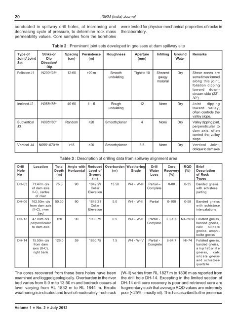
Table 2 : Prominent joint sets developed in gneisses at dam spillway site<br />
Type of Strike or Spacing Persistence Roughness Aperture Infilling Ground Remarks<br />
Joint/ Joint Dip (cm) (m) (mm) Water<br />
Set<br />
Direction/<br />
Dip<br />
Foliation J1 N200 o /25 o 12-60 >20 m Smooth Tight to 10 Sheared Dry Shear zones are<br />
undulating gaugy some times formed<br />
material<br />
along this joint,<br />
foliation dipping<br />
toward downstream<br />
side (22°-<br />
30°).<br />
Inclined J2 N055 o /55 o 40-60 1 – 5 Rough 12 None Dry Joint dipping<br />
undulating toward valley,<br />
often controls the<br />
valley slope.<br />
Subvertical N095 o /80 o Random >20 Smooth planar 4 None Dry Valley dipping joint,<br />
J3<br />
perpendicular to<br />
dam axis, often<br />
control the valley<br />
slope.<br />
Vertical J4 N055 o -070 o /V >18 >20 Smooth planar 3-5 None Dry Vertical Joint,<br />
oblique to dam axis<br />
Table 3 : Description of drilling data from spillway alignment area<br />
Drill Location Total Angle with Reduced Overburden Weathering Drill Core RQD Brief<br />
Hole Depth Horizontal Level of (m) Grade Water Recovery (%) Description<br />
No (m) Ground Loss (%) of Rock<br />
(m)<br />
Types<br />
DH-03 71.47m d/s 75.0 90 1849.29 13.50 W-I - W-III Partial – 0-80 0-35 Banded gneiss<br />
of dam axis Collar Complete with schistose<br />
II-C, centre Elevation parting<br />
of river<br />
DH-06 162.50m d/s 50.30 90 1849.21 5.0 W-I - W-III Partial 0-100 0-58 Banded gneiss<br />
from dam axis Collar with schistose<br />
(II-C), river Elevation intercalations<br />
bed<br />
DH-13 47.00m d/s 150 90 1930.79 0.5 W-I - W-III Partial - 3.3-100 Nil-78.66 Foliated gneiss,<br />
perpendicular Complete banded gneiss,<br />
to dam axis calc silicate<br />
gneiss, amphibolite<br />
gneiss<br />
DH-14 15.50m d/s 126.0 59 1850.75 1.5 W-I - W-IV Partial - 8-94.7 Nil-74 Foliated gneiss,<br />
from dam Complete banded gneiss,<br />
axis (II-C),<br />
amphibolite<br />
right bank gneiss, calc<br />
silicate gneiss<br />
and schistose<br />
quartzite<br />
The cores recovered from these bore holes have been<br />
examined and logged geologically. Overburden in the river<br />
bed varies from 5.0 m to 13.50 m and bedrock occurs at<br />
level varying from RL 1832 m to RL 1844 m. Erratic<br />
weathering is indicated and level of moderately fresh rock<br />
(W-II) varies from RL 1827 m to 1836 m as reported from<br />
the drill hole DH-14. Excepting in the limited section of<br />
DH-14 drill core recovery is poor and retrieved core are<br />
fragmentary such that average RQD values are extremely<br />
poor (