

The Ecology of the Seagrasses of South Florida - USGS National ...
The Ecology of the Seagrasses of South Florida - USGS National ...
The Ecology of the Seagrasses of South Florida - USGS National ...

Create successful ePaper yourself
Turn your PDF publications into a flip-book with our unique Google optimized e-Paper software.
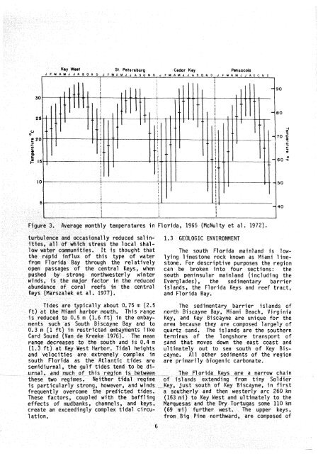
Key Went St Pstarobur~ Cedor Key Panaocola<br />
J F M A M J J A $ O N D J F M ~ M J J A ~ ~ O N D J F M A M J J A S O N D J ~ . M A M J J A S ~ , N C<br />
-"-<br />
-, ,<br />
Flgura? 3. Average monthly temperatures in <strong>Florida</strong>, 1965 (McNul ty et a1 . 1972).<br />
turbulence and occasional ly reduced sa1 in- 1.3 GEOLOGIC ENVTRQMl4ENT<br />
Ottes, all sf whlch stress <strong>the</strong> local shallaw<br />
wader cmunities. Et is thought that <strong>The</strong> south <strong>Florida</strong> mainland is low<strong>the</strong><br />
rapid influx <strong>of</strong> this type <strong>of</strong> water lying 1 imestone rock known as Miami 1 ime-<br />
Prom <strong>Florida</strong> Bay through <strong>the</strong> relatively stone. For descriptive purposes <strong>the</strong> region<br />
open passages <strong>of</strong> <strong>the</strong> central Keys, when can be broken into four sections: <strong>the</strong><br />
puohsd by strong northwesterly winter south peninsular main1 and (including <strong>the</strong><br />
wlnds, is <strong>the</strong> majar factor in <strong>the</strong> reduced Everglades), <strong>the</strong> sedimentary barrier<br />
abundance <strong>of</strong> coral reefs in <strong>the</strong> central islands, <strong>the</strong> Florfda Keys and reef tract,<br />
kys (Warszalek et 81, 1977).<br />
and <strong>Florida</strong> Bay.<br />
Tides are typically about 0,75 m (2,s <strong>The</strong> sedfmentary barrier islands <strong>of</strong><br />
ft) at <strong>the</strong> MJarni harbor muth. Thfs range north Biscayne Bay, Mr'ami Beach, Virginia<br />
is reduced to (I6, 5 m (1,6 ft) f n <strong>the</strong> embay- Key, and Key Biscayne are unique for <strong>the</strong><br />
ntents such as <strong>South</strong> Biscayne Bay and to area because <strong>the</strong>y are composed largely <strong>of</strong><br />
O,3 m (I ft) in restricted mbaylents like quartz sand, <strong>The</strong> islands are <strong>the</strong> sou<strong>the</strong>rn<br />
Card Sound (Van de #reeke 1976). <strong>The</strong> mean terminus <strong>of</strong> <strong>the</strong> longshore transport <strong>of</strong><br />
range decreases to <strong>the</strong> south and js 0.4 m sand that moves down <strong>the</strong> east coast and<br />
(1.3 ft) at Key Mest Harbor, Tidal hejghts ultimately out to sea south <strong>of</strong> Key Bisand<br />
velocities are extrmely complex in cayne. All o<strong>the</strong>r sediments <strong>of</strong> <strong>the</strong> region<br />
south <strong>Florida</strong> as <strong>the</strong> Allantl'c tides are are primarily biogenic carbonate.<br />
aemidiurnal , <strong>the</strong> gulf tides tend to be diurnal,<br />
and much <strong>of</strong> this regSon is between <strong>The</strong> <strong>Florida</strong> Keys are a narrow chain<br />
<strong>the</strong>se two regimes. Nei<strong>the</strong>r tidal regime <strong>of</strong> islands extending from tiny Soldier<br />
is particularly strong, however, and winds Key, just south <strong>of</strong> Key Biscayne, in first<br />
frequently overcome <strong>the</strong> predicted tides. a sou<strong>the</strong>rly and <strong>the</strong>n westerly arc 260 km<br />
<strong>The</strong>se factors, coupled with <strong>the</strong> baffl Jng (563 mi) to Key Mest and ultimately to <strong>the</strong><br />
effects <strong>of</strong> mudbanks, channels, and keys, Marquesas and <strong>the</strong> Dry Tortugas some 110 km<br />
create an exceedingly complex tidal cSrcu- (69 mi) fur<strong>the</strong>r west, <strong>The</strong> upper keys,<br />
1 ation. from Big Pine no~thward, are composed <strong>of</strong><br />
6


