DFS Resource Assessment - Delaware Department of Agriculture
DFS Resource Assessment - Delaware Department of Agriculture
DFS Resource Assessment - Delaware Department of Agriculture
Create successful ePaper yourself
Turn your PDF publications into a flip-book with our unique Google optimized e-Paper software.
Refuge is also located within this area and it is<br />
essential that conservation efforts are coordinated<br />
with this federal refuge.<br />
Blackbird Creek is the most rural watershed<br />
within <strong>Delaware</strong>’s most urbanized county (New<br />
Castle). Preserving the rural character <strong>of</strong> the<br />
watershed is a high priority, as well as<br />
coordinating land-protection efforts in the<br />
Blackbird-Millington Corridor. Furthermore,<br />
protecting, buffering, and restoring Coastal Plain<br />
Ponds is an additional priority.<br />
The forests within the Inland Bays region <strong>of</strong> the<br />
priority area are primarily headwater forests. This<br />
area is rapidly developing due to its proximity to<br />
the coast and water quality degradation is a<br />
significant concern. Important issues within this<br />
watershed are forested buffers and minimizing the<br />
additional loss <strong>of</strong> forested blocks from further<br />
development.<br />
The Piedmont Basin has <strong>Delaware</strong>’s only mature<br />
Piedmont forests and thus deserves special<br />
attention. The area contains relatively few large<br />
forested blocks and most <strong>of</strong> them are already<br />
permanently protected, so most efforts will focus<br />
on connecting these blocks and attempting to<br />
control the high occurrence <strong>of</strong> invasive species,<br />
primarily plants that are found within this highly<br />
urbanized and fragmented area.<br />
The Chesapeake Basin is the most rural region<br />
within the priority area. It contains <strong>Delaware</strong>’s<br />
highest concentration <strong>of</strong> working forests and it is<br />
vital to <strong>Delaware</strong>’s economy that these working<br />
forests are maintained and protected. This region<br />
is also home to most <strong>of</strong> <strong>Delaware</strong>’s baldcypress<br />
forests and to a population <strong>of</strong> the Delmarva fox<br />
squirrel. Efforts to protect and restore these<br />
species are very important, as is the need to<br />
improve water quality to the Chesapeake Bay.<br />
Additionally, coordination among federal, state,<br />
and local partners will be critical in a<br />
collaborative effort to improve water quality.<br />
VII. URBAN PRIORITY<br />
LANDSCAPE AREAS<br />
Prioritized Urban Communities<br />
A. Overview<br />
Like many states,<br />
<strong>Delaware</strong> has experienced<br />
tremendous growth over<br />
the last decade. During<br />
that time, previously<br />
unincorporated rural areas<br />
have been annexed and<br />
subsequently developed<br />
by many communities<br />
throughout the state. While<br />
this creates new<br />
opportunities for urban<br />
forestry, this growth also<br />
adds pressure on the urban<br />
forest resource. Only until the recent recession has this<br />
growth subsided. As funding for urban forestry has<br />
increasingly become scarce it is evident that a<br />
prioritization <strong>of</strong> communities was necessary to increase<br />
the efficacy <strong>of</strong> the <strong>Delaware</strong> Urban and Community<br />
Forestry (U&CF) Program.<br />
Therefore, all 57 incorporated municipalities were<br />
evaluated using a Geographic Information System (GIS).<br />
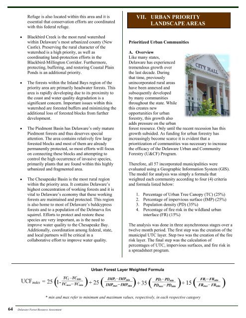
The model for analysis was simply a formula that<br />
weighted each community according to four (4) criteria<br />
and formula listed below:<br />
1. Percentage <strong>of</strong> Urban Tree Canopy (TC) (25%)<br />
2. Percentage <strong>of</strong> impervious surface (IMP) (25%)<br />
3. Population density (PD) (35%)<br />
4. Percentage <strong>of</strong> fire risk in the wildland urban<br />
interface (FR) (15%)<br />
The analysis was done in three asynchronous stages over a<br />
twelve month period. The first step was the creation <strong>of</strong> the<br />
municipal UTC layer. Step two was the creation <strong>of</strong> the fire<br />
risk layer. The final step was the calculation <strong>of</strong><br />
percentages <strong>of</strong> UTC, impervious surfaces, and fire risk in<br />
a spreadsheet program.<br />
Urban Forest Layer Weighted Formula<br />
* min and max refer to minimum and maximum values, respectively, in each respective category<br />
64 <strong>Delaware</strong> Forest <strong>Resource</strong> <strong>Assessment</strong>


