DFS Resource Assessment - Delaware Department of Agriculture
DFS Resource Assessment - Delaware Department of Agriculture
DFS Resource Assessment - Delaware Department of Agriculture

You also want an ePaper? Increase the reach of your titles
YUMPU automatically turns print PDFs into web optimized ePapers that Google loves.
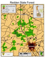
forest priority area includes the<br />
major cities within the corridor –<br />
Wilmington and Newark; the<br />
rural priority forest area contains<br />
three small rural watersheds<br />
located just north <strong>of</strong> the interstate,<br />
which contain the best examples<br />
<strong>of</strong> Piedmont forests within the<br />
state. Below is a description <strong>of</strong><br />
the I-95 Corridor developed by<br />
the U.S. Forest Service.<br />
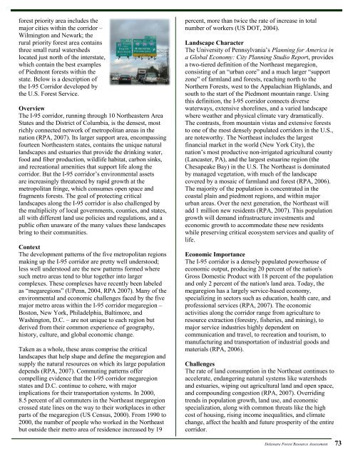
Overview<br />
The I-95 corridor, running through 10 Northeastern Area<br />
States and the District <strong>of</strong> Columbia, is the densest, most<br />
richly connected network <strong>of</strong> metropolitan areas in the<br />
nation (RPA, 2007). Its larger support area, encompassing<br />
fourteen Northeastern states, contains the unique natural<br />
landscapes and estuaries that provide the drinking water,<br />
food and fiber production, wildlife habitat, carbon sinks,<br />
and recreational amenities that support life along the<br />
corridor. But the I-95 corridor’s environmental assets<br />
are increasingly threatened by rapid growth at the<br />
metropolitan fringe, which consumes open space and<br />
fragments forests. The goal <strong>of</strong> protecting critical<br />
landscapes along the I-95 corridor is also challenged by<br />
the multiplicity <strong>of</strong> local governments, counties, and states,<br />
all with different land use policies and regulations, and a<br />
public <strong>of</strong>ten unaware <strong>of</strong> the many values these landscapes<br />
bring to their communities.<br />
Context<br />
The development patterns <strong>of</strong> the five metropolitan regions<br />
making up the I-95 corridor are pretty well understood;<br />
less well understood are the new patterns formed where<br />
such metro areas tend to blur together into larger<br />
complexes. These complexes have recently been labeled<br />
as “megaregions” (UPenn, 2004, RPA 2007). Many <strong>of</strong> the<br />
environmental and economic challenges faced by the five<br />
major metro areas within the I-95 corridor megaregion –<br />
Boston, New York, Philadelphia, Baltimore, and<br />
Washington, D.C. – are not unique to each region but<br />
derived from their common experience <strong>of</strong> geography,<br />
history, culture, and global economic change.<br />
Taken as a whole, these areas comprise the critical<br />
landscapes that help shape and define the megaregion and<br />
supply the natural resources on which its large population<br />
depends (RPA, 2007). Commuting patterns <strong>of</strong>fer<br />
compelling evidence that the I-95 corridor megaregion<br />
states and D.C. continue to cohere, with major<br />
implications for their transportation systems. In 2000,<br />
8.5 percent <strong>of</strong> all commuters in the Northeast megaregion<br />
crossed state lines on the way to their workplaces in other<br />
parts <strong>of</strong> the megaregion (US Census, 2000). From 1990 to<br />
2000, the number <strong>of</strong> people who worked in the Northeast<br />
but outside their metro area <strong>of</strong> residence increased by 19<br />
percent, more than twice the rate <strong>of</strong> increase in total<br />
number <strong>of</strong> workers (US DOT, 2004).<br />
Landscape Character<br />
The University <strong>of</strong> Pennsylvania’s Planning for America in<br />
a Global Economy: City Planning Studio Report, provides<br />
a two-tiered definition <strong>of</strong> the Northeast megaregion,<br />
consisting <strong>of</strong> an “urban core” and a much larger “support<br />
zone” <strong>of</strong> farmland and forests, reaching north to the<br />
Northern Forests, west to the Appalachian Highlands, and<br />
south to the start <strong>of</strong> the Piedmont mountain range. Using<br />
this definition, the I-95 corridor connects diverse<br />
waterways, extensive shorelines, and a varied landscape<br />
where weather and physical climate vary dramatically.<br />
The contrasts, from mountain vistas and extensive forests<br />
to one <strong>of</strong> the most densely populated corridors in the U.S.,<br />
are noteworthy. The Northeast includes the largest<br />
financial market in the world (New York City), the<br />
nation’s most productive non-irrigated agricultural county<br />
(Lancaster, PA), and the largest estuarine region (the<br />
Chesapeake Bay) in the U.S. The Northeast is dominated<br />
by managed vegetation, with much <strong>of</strong> the landscape<br />
covered by a mosaic <strong>of</strong> farmland and forest (RPA, 2006).<br />
The majority <strong>of</strong> the population is concentrated in the<br />
coastal plain and piedmont regions, and within major<br />
urban areas. Over the next generation, the Northeast will<br />
add 1 million new residents (RPA, 2007). This population<br />
growth will demand infrastructure investments and<br />
economic growth to accommodate these new residents<br />
while preserving critical ecosystem services and quality <strong>of</strong><br />
life.<br />
Economic Importance<br />
The I-95 corridor is a densely populated powerhouse <strong>of</strong><br />
economic output, producing 20 percent <strong>of</strong> the nation's<br />
Gross Domestic Product with 18 percent <strong>of</strong> the population<br />
and only 2 percent <strong>of</strong> the nation's land area. Today, the<br />
megaregion has a largely service-based economy,<br />
specializing in sectors such as education, health care, and<br />
pr<strong>of</strong>essional services (RPA, 2007). The economic<br />
activities along the corridor range from agriculture to<br />
resource extraction (forestry, fisheries, and mining), to<br />
major service industries highly dependent on<br />
communication and travel, to recreation and tourism, to<br />
manufacturing and transportation <strong>of</strong> industrial goods and<br />
materials (RPA, 2006).<br />
Challenges<br />
The rate <strong>of</strong> land consumption in the Northeast continues to<br />
accelerate, endangering natural systems like watersheds<br />
and estuaries, wiping out agricultural land and open space,<br />
and compounding congestion (RPA, 2007). Overriding<br />
trends in population growth, land use, and economic<br />
specialization, along with common threats like the high<br />
cost <strong>of</strong> housing, rising income inequalities, and climate<br />
change, affect the health and future prosperity <strong>of</strong> the entire<br />
corridor.<br />
<strong>Delaware</strong> Forest <strong>Resource</strong> <strong>Assessment</strong> 73