o - Waste Isolation Pilot Plant
o - Waste Isolation Pilot Plant
o - Waste Isolation Pilot Plant

Create successful ePaper yourself
Turn your PDF publications into a flip-book with our unique Google optimized e-Paper software.
u<br />
o<br />
o<br />
o<br />
o<br />
o<br />
u<br />
D<br />
U<br />
o<br />
[J<br />
o<br />
[J<br />
U<br />
o<br />
o<br />
o<br />
[J<br />
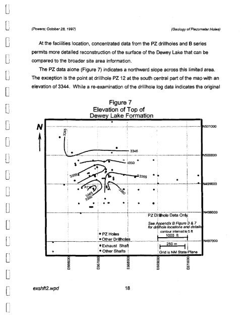
(Powers; October28, 1997)<br />
At the facilities location, concentrated data from the PZ drillholes and B series<br />
permits more detailed reconstruction of the surface of the Dewey Lake that can be<br />
compared to the broader site area information.<br />
The PZ data alone (Figure 7) indicates a northward slope across this limited area.<br />
The exception is the point at drillhole PZ 12 at the south central part of the map with an<br />
elevation of 3344. While a re-examination of the drillhole log data indicates th,e original<br />
N<br />
t<br />
exshft2. wpd<br />
Figure 7<br />
Elevation of Top of<br />
Dewe Lake Formation<br />
•<br />
"",,:::a..',<br />
e "S"' -e.' $<br />
, - ... -'3350<br />
: ",,'·<br />
•<br />
_.._--.-~ ~- ~~i~---~"-~ .;<br />
~i;j). ,<br />
• •• .! • • 't<br />
•<br />
.. ; , j<br />
18<br />
(Geology ofPiezometer Holes)<br />
.. __... ~~. __L ..._.... --11N501000<br />
•<br />
• I .<br />
. ...----1-----"- N499000<br />
!<br />
---+-__~_-_I--_.__._-----:----_.----_._--_.._-~-----<br />
i i PZ D~illhole Data On~<br />
. . See ~ppendix B Figure b& 7<br />
for drqlho/e locations arid detail<br />
. Z I I. I contour interval iSiS It<br />
N498000<br />
i-P Hoes' , 100011 '<br />
-.__.._..;.. :.._Oth~pril!!!Q!$-.------.--• ..__ , N497000<br />
. , , J :t<br />
: ,.Exhaust Sha~ !I 250 m II<br />
• i !- Other Shafts i ! Grid is NM State ,Plane