o - Waste Isolation Pilot Plant
o - Waste Isolation Pilot Plant
o - Waste Isolation Pilot Plant

Create successful ePaper yourself
Turn your PDF publications into a flip-book with our unique Google optimized e-Paper software.
[J<br />
o<br />
[]<br />
U<br />
[]<br />
D<br />
[]<br />
[J<br />
[J<br />
U<br />
D<br />
[]<br />
U<br />
[J<br />
[]<br />
[J<br />
o<br />
u<br />
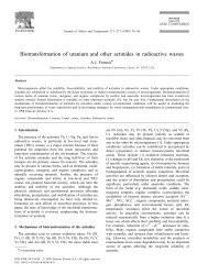
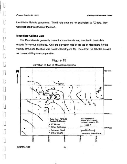
(Powers; October28, 1997)<br />
Mescalero Caliche Data<br />
•<br />
3405<br />
Figure 15<br />
Elevation of Top of Mescalero Caliche<br />
•<br />
P21<br />
. '\ .<br />
•<br />
--~.: D~'_Pz&B<br />
~... __ :S~:;:::L<br />
• Exhaust Shaft<br />
,• Other Shafts<br />
•<br />
j<br />
.~ \<br />
•<br />
(Geology ofPiezometerHoles)<br />
identifiable Gatutia sandstone, The B hole data are not equivalent to PZ data, they<br />
were not used to construct the map.<br />
The Mescalero is generally present across the site and is noted in basic da'ta<br />
reports for various drillholes. Only the elevation map of the top of Mescalero fClr the<br />
vicinity of the site facilities was constructed (Figure 15). Data from the B holes as well<br />
as current drilling are comparable.<br />
N<br />
t<br />
exshft2. wpd 27<br />
See Appendix B '<br />
Figure 15 for demUs<br />
: contour interval Is 5 ft<br />
' 1000 It l<br />
I<br />
.n!<br />
N501000<br />
N500000<br />
..\~.N499000<br />
• '?, '?, ",<br />
~ 'b ~.<br />
'"<br />
. N498000<br />
.......-___ -. L __.~_ N497000<br />
I 250m Ii<br />
Grid Is NM State .Plane