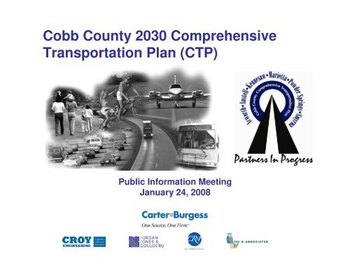
Cobb County 2030 Comprehensive Transportation Plan (CTP)
Cobb County 2030 Comprehensive Transportation Plan (CTP)
Cobb County 2030 Comprehensive Transportation Plan (CTP)

You also want an ePaper? Increase the reach of your titles
YUMPU automatically turns print PDFs into web optimized ePapers that Google loves.
<strong>Cobb</strong> <strong>County</strong> <strong>2030</strong> <strong>Comprehensive</strong><br />
<strong>Transportation</strong> <strong>Plan</strong> (<strong>CTP</strong>)<br />
Public Information Meeting<br />
January 24, 2008
Purpose of <strong>CTP</strong><br />
• Identifies long-range multimodal transportation<br />
needs countywide through <strong>2030</strong><br />
• Recommendations include roadway, freight,<br />
transit, bicycle and pedestrian solutions<br />
• Compares needs against funding assumptions<br />
to develop strategic vision for implementation<br />
• Serves as a transportation planning “platform”<br />
upon which future detailed project concept<br />
development efforts will build<br />
<strong>Cobb</strong> <strong>County</strong> <strong>Comprehensive</strong> <strong>Transportation</strong> <strong>Plan</strong>
Study Background<br />
• 2-year effort<br />
• Interjurisdictional, including <strong>Cobb</strong>’s<br />
unincorporated areas and 6 municipalities<br />
• Analysis reported for 4 “planning areas”<br />
encompassing entire county<br />
• 2 primary study parts: <strong>Transportation</strong> elements<br />
of DCA <strong>Comprehensive</strong> <strong>Plan</strong>s and enhanced<br />
countywide multimodal recommendations<br />
• <strong>Plan</strong>ning “horizon” of <strong>2030</strong><br />
<strong>Cobb</strong> <strong>County</strong> <strong>Comprehensive</strong> <strong>Transportation</strong> <strong>Plan</strong>
Coordination and Outreach<br />
• Project Management Team (PMT)<br />
– Representatives from <strong>County</strong>, cities, ARC and GDOT<br />
– 12 meetings over the course of the study<br />
• Stakeholder Coordinating Committee (SCC)<br />
– Representatives from public agencies and private organizations<br />
– Appointed by each <strong>County</strong> Commissioner and municipality<br />
– 7 meetings (3/06, 6/06, 9/06, 1/07, 5/07, 8/07, 10/07)<br />
• <strong>Cobb</strong> Paulding Working Group (CPWG)<br />
– Specific focus on traffic within western <strong>Cobb</strong> and Paulding <strong>County</strong> impact<br />
– Representatives selected by <strong>Cobb</strong> <strong>County</strong>, Paulding <strong>County</strong> and the City of<br />
Marietta<br />
– 6 meetings (10/06, 1/07, 5/07, 8/07, 10/07, 12/07)<br />
• Special briefings conducted for municipalities and CIDs as requested<br />
throughout study duration<br />
<strong>Cobb</strong> <strong>County</strong> <strong>Comprehensive</strong> <strong>Transportation</strong> <strong>Plan</strong>
Public Involvement<br />
• Public involvement meetings<br />
– 5 rounds (4/06, 8/06, 2/07, 10-11/07, 1/08)<br />
– 628 attendees from first 4 rounds<br />
• Study website (www.cobbdot.org/ctp)<br />
• Newsletters (4)<br />
• Fact sheets, press releases and meeting flyers<br />
• Stakeholder interviews (52 community leaders)<br />
• Surveys (1000 random phone interviews)<br />
• Contact database (600)<br />
<strong>Cobb</strong> <strong>County</strong> <strong>Comprehensive</strong> <strong>Transportation</strong> <strong>Plan</strong>
Technical Process<br />
• Accepted methodologies and analyses used to<br />
ensure compatibility with regional planning<br />
processes<br />
• Regional model adapted to provide greater<br />
<strong>Cobb</strong> specific detail on travel patterns and<br />
volumes<br />
• Cost estimates and funding assumptions based<br />
on local, regional and state sources and tools<br />
<strong>Cobb</strong> <strong>County</strong> <strong>Comprehensive</strong> <strong>Transportation</strong> <strong>Plan</strong>
Project Identification & Analysis Process<br />
Travel Demand Model<br />
Results<br />
(<strong>2030</strong> E+C)<br />
Safety Data<br />
Transit Propensity<br />
Evaluation<br />
Other <strong>Plan</strong>s<br />
Potential Improvement<br />
Options<br />
Projects Organized by:<br />
•Mode<br />
•Corridors<br />
•<strong>Plan</strong> Area<br />
•Connections w/other<br />
Projects<br />
•Model/Off Model<br />
Stakeholders &<br />
CPWG<br />
Public Involvement<br />
Activities<br />
Project Satisfies<br />
Existing & Future<br />
Need<br />
Project Does<br />
Not Meet<br />
Identified Need<br />
No Further<br />
Consideration<br />
Staff & Agency Input<br />
NEEDS BASED PLAN<br />
Elected Officials<br />
Field Observation<br />
Project Prioritization and<br />
Development of Financially<br />
Constrained Program of Projects<br />
(See Figure 1B)<br />
<strong>Cobb</strong> <strong>County</strong> <strong>Comprehensive</strong> <strong>Transportation</strong> <strong>Plan</strong>
Recommendations<br />
• Multimodal Projects<br />
– Roadway<br />
– Transit<br />
– Multi use trails<br />
– Pedestrian facilities<br />
• Policies and Procedures<br />
– Roadway<br />
– Access management<br />
– Freight truck routes<br />
– Travel demand management (TDM)<br />
– Bicycle, pedestrian and multi use trail facilities<br />
<strong>Cobb</strong> <strong>County</strong> <strong>Comprehensive</strong> <strong>Transportation</strong> <strong>Plan</strong>
Factors Considered in Project Selection<br />
• Congestion<br />
– Overcapacity<br />
– Daily Delay<br />
– Travel Time Index (TTI)<br />
• Safety<br />
• Thoroughfare <strong>Plan</strong> Classification<br />
• Capital/Operating Costs per Rider<br />
• Potential Community and Economic Impacts<br />
<strong>Cobb</strong> <strong>County</strong> <strong>Comprehensive</strong> <strong>Transportation</strong> <strong>Plan</strong>
Roadway Improvements<br />
• 137 total<br />
– Widenings = 50<br />
– New roadways, extensions/connectors = 9<br />
– Major intersection improvements (grade separation,<br />
realignment, new interchange) = 28<br />
– Operational (access management, shoulder widening,<br />
corridor improvements) = 30<br />
– Operational intersection improvements (turn lanes,<br />
signalization) = 36<br />
*Some projects include two types of improvements (e.g., widening and major intersection improvements)<br />
<strong>Cobb</strong> <strong>County</strong> <strong>Comprehensive</strong> <strong>Transportation</strong> <strong>Plan</strong>
Transit Improvements<br />
• 17 total<br />
– US 41 high capacity transit (feasibility study)<br />
– Express bus service = 5<br />
– Limited stop bus service = 5<br />
– Local bus service = 3<br />
– Circulator shuttle service = 3<br />
• Assume associated feeder routes and park and<br />
ride lots are in place as appropriate<br />
<strong>Cobb</strong> <strong>County</strong> <strong>Comprehensive</strong> <strong>Transportation</strong> <strong>Plan</strong>
Trail & Pedestrian Improvements<br />
• Multi use trails = 44 total (~168 linear miles)<br />
• Pedestrian facilities = 80 total (~ 41 linear miles)<br />
– Safety & key corridor = 34<br />
– LCI connectivity = 11<br />
– School/activity center buffer = 35<br />
• Assume roadway improvements will incorporate<br />
bicycle/pedestrian facilities and trail connections as<br />
appropriate<br />
• In addition to, not in lieu of, ongoing efforts to expand the<br />
pedestrian/bicycle/trail network<br />
<strong>Cobb</strong> <strong>County</strong> <strong>Comprehensive</strong> <strong>Transportation</strong> <strong>Plan</strong>
Recommendations by <strong>Plan</strong>ning Area<br />
Project Type<br />
Northwest<br />
(Acworth &<br />
Kennesaw)<br />
Northeast<br />
Southeast<br />
(Marietta &<br />
Smyrna)<br />
Southwest<br />
(Austell & Powder<br />
Springs)<br />
Roadway<br />
40<br />
42<br />
43<br />
30<br />
Transit<br />
8<br />
5<br />
7<br />
6<br />
Trail<br />
9<br />
5<br />
20<br />
18<br />
Pedestrian<br />
14<br />
6<br />
32<br />
34<br />
TOTAL<br />
71<br />
58<br />
102<br />
88<br />
*Some projects are included in more than one planning area<br />
<strong>Cobb</strong> <strong>County</strong> <strong>Comprehensive</strong> <strong>Transportation</strong> <strong>Plan</strong>
System Performance Results<br />
Performance Measure<br />
2005<br />
Base Scenarios<br />
<strong>2030</strong> E+C*<br />
<strong>2030</strong> Needs<br />
Based <strong>Plan</strong><br />
Travel Time Index<br />
1.43<br />
1.73<br />
1.55<br />
>6 Hrs of Congestion<br />
(% of Lane-Miles)<br />
1%<br />
5%<br />
2%<br />
2-6 Hrs of Congestion<br />
% of Lane-Miles)<br />
18%<br />
27%<br />
20%<br />
Access Management Policies<br />
• Continued adherence to development standards<br />
• Formation of access review committee<br />
• Completion of corridor specific access management<br />
plans, beginning with arterials<br />
• Required access management plan as part of concept<br />
development process for arterial and major collector<br />
widenings and upgrades<br />
• Access Management Overlay Districts (AMODs)<br />
• Appropriate access management applications based<br />
upon functional classification typology<br />
<strong>Cobb</strong> <strong>County</strong> <strong>Comprehensive</strong> <strong>Transportation</strong> <strong>Plan</strong>
Truck Freight Policies<br />
• Land use compatibility<br />
• Operations and design<br />
• Maintenance<br />
• Intermodal facilities<br />
<strong>Cobb</strong> <strong>County</strong> <strong>Comprehensive</strong> <strong>Transportation</strong> <strong>Plan</strong>
Travel Demand Management Policies<br />
• TMA (<strong>Transportation</strong> Management Association)<br />
expansion and development<br />
• Required TDM plans for new large land<br />
developments<br />
• CIDs critical to TDM implementation<br />
<strong>Cobb</strong> <strong>County</strong> <strong>Comprehensive</strong> <strong>Transportation</strong> <strong>Plan</strong>
Bicycle, Pedestrian & Trail Policies<br />
• Strategically target investments to most suitable areas<br />
• Require roadway projects to include pedestrian and<br />
bicycle facilities as appropriate<br />
• Update zoning code to require pedestrian and bicycle<br />
facilities and amenities in commercial and mixed use<br />
developments<br />
• Establish guidelines for ensuring connectivity between<br />
neighborhoods and adjacent land uses<br />
• Promote education, enforcement and awareness<br />
programs to encourage increased use of and safety for<br />
bicycling and walking<br />
<strong>Cobb</strong> <strong>County</strong> <strong>Comprehensive</strong> <strong>Transportation</strong> <strong>Plan</strong>
Estimated Costs by Category<br />
• Roadway = $4,504,029,000<br />
– By System<br />
• On System (US and State Route) Improvements = $3,532,576,000<br />
• Off System (<strong>County</strong> and Local Road) Improvements = $971,453,000<br />
– By Type<br />
• Capacity Improvements = $3,274,872,000<br />
• Major Intersection Improvements = $798,344,000<br />
• Operational Improvements = $430,813,000<br />
• Transit = $1,132,803,000 (Capital & Operating)<br />
• Multi Use Trails = $168,856,000<br />
• Pedestrian = $38,603,000<br />
– Safety & key corridor = $18,103,000<br />
– LCI connectivity = $7,330,000<br />
– School & activity center buffer = $13,170,000<br />
• Total Needs Based <strong>Plan</strong> Cost = $5,844,291,000<br />
*Project costs escalated to the <strong>CTP</strong> midpoint year (12 years) to account for inflation<br />
<strong>Cobb</strong> <strong>County</strong> <strong>Comprehensive</strong> <strong>Transportation</strong> <strong>Plan</strong>
Use of <strong>Plan</strong> into the Future<br />
• To move specific transportation projects forward<br />
(prioritization, funding, detailed concept definition)<br />
• For project inclusion in ARC’s Regional <strong>Transportation</strong><br />
<strong>Plan</strong> (must be drawn from and supported by the<br />
countywide <strong>CTP</strong>)<br />
• As a staff resource during interjurisdictional and<br />
intercounty coordination efforts<br />
• To ensure land use / transportation connectivity and<br />
shifting travel behaviors are monitored by <strong>Plan</strong> updates<br />
(every 3-5 years)<br />
<strong>Cobb</strong> <strong>County</strong> <strong>Comprehensive</strong> <strong>Transportation</strong> <strong>Plan</strong>
How to Comment?<br />
• Review the draft <strong>CTP</strong><br />
– Online at www.cobbdot.org/ctp<br />
– <strong>Cobb</strong> Regional Libraries – Central, Mountain View, South <strong>Cobb</strong> and<br />
West <strong>Cobb</strong><br />
– <strong>Cobb</strong> <strong>County</strong> Government Building on Marietta Square, 3rd Floor and<br />
Communications Office<br />
– <strong>Cobb</strong> DOT offices on <strong>County</strong> Services Parkway<br />
– City Hall in Acworth, Austell, Kennesaw, Marietta, Powder Springs and<br />
Smyrna<br />
• Provide your written comments by February 5<br />
– Prior to leaving tonight<br />
– Laraine Vance, <strong>Plan</strong>ning Division Manager, <strong>Cobb</strong> DOT –<br />
transportation@cobbcounty.org, 1890 <strong>County</strong> Services Pkwy, Marietta,<br />
30080<br />
– Carla Bamatraf, Study Consultant Team, Carter & Burgess –<br />
carla.bamatraf@c-b.com, 1718 Peachtree St, Ste 400, Atlanta, 30309<br />
<strong>Cobb</strong> <strong>County</strong> <strong>Comprehensive</strong> <strong>Transportation</strong> <strong>Plan</strong>