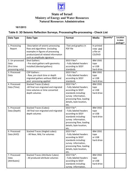
Table 8: 3D Seismic Reflection Surveys, Processing/Re-processing
Table 8: 3D Seismic Reflection Surveys, Processing/Re-processing
Table 8: 3D Seismic Reflection Surveys, Processing/Re-processing

You also want an ePaper? Increase the reach of your titles
YUMPU automatically turns print PDFs into web optimized ePapers that Google loves.
State of Israel<br />
Ministry of Energy and Water <strong>Re</strong>sources<br />
Natural <strong>Re</strong>sources Administration<br />
16/1/2013<br />
<strong>Table</strong> 8: <strong>3D</strong> <strong>Seismic</strong> <strong><strong>Re</strong>flection</strong> <strong>Surveys</strong>, <strong>Processing</strong>/<strong>Re</strong>-<strong>processing</strong> - Check List<br />
Data Type<br />
1. <strong>Processing</strong><br />
<strong>Re</strong>port<br />
2. Un-processed<br />
Data<br />
(first time<br />
<strong>processing</strong> only)<br />
3. Processed<br />
Data<br />
4. Processed<br />
Data (Time)<br />
5. Processed<br />
Data (Depth)<br />
6. Processed<br />
Data (AVO)<br />
7. Processed<br />
Data<br />
(Attributes)<br />
Data Type<br />
-Description of seismic <strong>processing</strong><br />
flow and algorithms (including<br />
examples in figures of <strong>processing</strong><br />
products)and all related information<br />
such as amplitude signature<br />
Shot Gathers:<br />
- Pre-stack gathers with geometry<br />
installed (idented gathers)<br />
CDP Gathers :<br />
- Raw, pre-stack time or depth<br />
migrated gathers without RMO and<br />
post- <strong>processing</strong> applied<br />
Stacked Traces (Cubes):<br />
-All final non-migrated and migrated<br />
time volumes or time converted<br />
depth volumes<br />
Stacked Traces (Cubes):<br />
-All final non-migrated and migrated<br />
depth volumes<br />
Stacked Traces (Angled cubes):<br />
- All Near, Mid, Far volumes<br />
Stacked Traces (Attribute Cubes):<br />
- All produced attribute volumes<br />
Format<br />
-Text and graphics in<br />
PDF file<br />
SEGY Files*:<br />
- Fully labeled headers<br />
according to SEGY<br />
standards<br />
SEGY Files*:<br />
- Fully labeled headers<br />
according to SEGY<br />
standards<br />
SEGY File*:<br />
- Fully labeled headers<br />
according to SEGY<br />
standards including:<br />
survey information,<br />
<strong>processing</strong> flow, loading<br />
details, byte location,<br />
etc.<br />
SEGY File*:<br />
- Fully labeled headers<br />
according to SEGY<br />
standards including:<br />
survey information,<br />
<strong>processing</strong> flow, loading<br />
details, byte location,<br />
etc.<br />
SEGY File*:<br />
- Fully labeled headers<br />
according to SEGY<br />
standards including:<br />
survey information,<br />
<strong>processing</strong> flow, loading<br />
details, byte location,<br />
etc.<br />
SEGY File*:<br />
- Fully labeled headers<br />
according to SEGY<br />
standards including:<br />
survey information,<br />
Media<br />
In printed<br />
copy and<br />
a file on<br />
CD/DVD<br />
IBM 3592<br />
tape<br />
or USB<br />
hard drive<br />
IBM 3592<br />
tape<br />
or USB<br />
hard drive<br />
IBM 3592<br />
tape<br />
or USB<br />
hard drive<br />
IBM 3592<br />
tape<br />
or USB<br />
hard drive<br />
IBM 3592<br />
tape<br />
or USB<br />
hard drive<br />
IBM 3592<br />
tape<br />
or USB<br />
hard drive<br />
Quantity*<br />
Location<br />
in data<br />
package*
State of Israel<br />
Ministry of Energy and Water <strong>Re</strong>sources<br />
Natural <strong>Re</strong>sources Administration<br />
<strong>processing</strong> flow, loading<br />
details, byte location,<br />
etc.<br />
8. Velocity Data<br />
9. Shipment<br />
<strong>Re</strong>port<br />
Velocities Models (Cubes):<br />
- Stacking velocity cubes<br />
- PSDM migration velocity model (V0,<br />
delta & epsilon cubes)<br />
List of delivered tape numbers<br />
- SEGY Files*:<br />
- Fully labeled headers<br />
according to SEGY<br />
standards<br />
-Text in<br />
XLS, DOC or PDF<br />
file<br />
IBM 3592<br />
tape<br />
or USB<br />
hard drive<br />
CD/DVD+<br />
printed<br />
copy<br />
Coordinate Systems:<br />
Marine Survey= UTM, WGS 84<br />
Land Survey= ITM, New Israeli Grid<br />
* To be filled by the operator's geophysicist<br />
Name: ________________________ Signature ____________________ Date:_______________<br />
License Operator: _____________________________________________________<br />
License/s name:_________________________________________________________<br />
Type of Survey: ___________________ Completion Date:_______________________<br />
<strong>Seismic</strong> Contractor:_________________________________