SENSITIVITY ANALYSIS - Department of Agriculture and ...
SENSITIVITY ANALYSIS - Department of Agriculture and ...
SENSITIVITY ANALYSIS - Department of Agriculture and ...

Create successful ePaper yourself
Turn your PDF publications into a flip-book with our unique Google optimized e-Paper software.
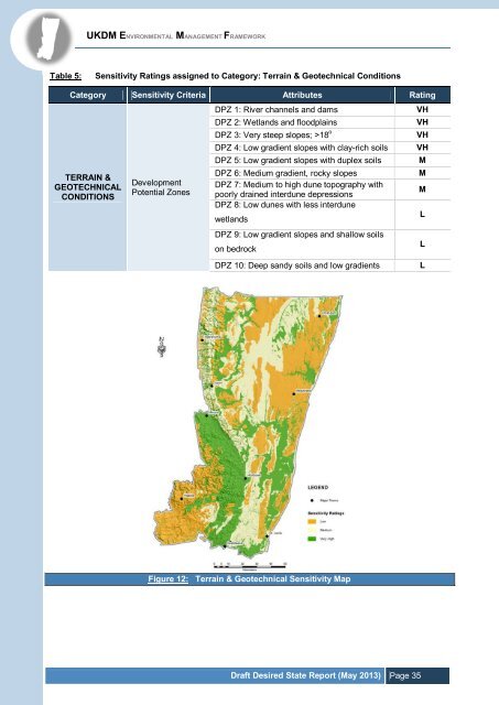
UKDM ENVIRONMENTAL MANAGEMENT FRAMEWORK<br />
Table 5:<br />
Sensitivity Ratings assigned to Category: Terrain & Geotechnical Conditions<br />
Category Sensitivity Criteria Attributes Rating<br />
TERRAIN &<br />
GEOTECHNICAL<br />
CONDITIONS<br />
Development<br />
Potential Zones<br />
DPZ 1: River channels <strong>and</strong> dams<br />
DPZ 2: Wetl<strong>and</strong>s <strong>and</strong> floodplains<br />
DPZ 3: Very steep slopes; >18 o<br />
DPZ 4: Low gradient slopes with clay-rich soils<br />
DPZ 5: Low gradient slopes with duplex soils<br />
DPZ 6: Medium gradient, rocky slopes<br />
DPZ 7: Medium to high dune topography with<br />
poorly drained interdune depressions<br />
DPZ 8: Low dunes with less interdune<br />
wetl<strong>and</strong>s<br />
DPZ 9: Low gradient slopes <strong>and</strong> shallow soils<br />
on bedrock<br />
DPZ 10: Deep s<strong>and</strong>y soils <strong>and</strong> low gradients<br />
VH<br />
VH<br />
VH<br />
VH<br />
M<br />
M<br />
M<br />
L<br />
L<br />
L<br />
Figure 12: Terrain & Geotechnical Sensitivity Map<br />
Draft Desired State Report (May 2013) Page 35