2 The story of Granite and Bega Cheese - Sapphire Coast
2 The story of Granite and Bega Cheese - Sapphire Coast
2 The story of Granite and Bega Cheese - Sapphire Coast

Create successful ePaper yourself
Turn your PDF publications into a flip-book with our unique Google optimized e-Paper software.
<strong>The</strong> grassl<strong>and</strong> on the Cobargo <strong>Granite</strong> st<strong>and</strong>s out as it has been cleared <strong>of</strong> native<br />
forest to expose fertile soils well suited to pasture <strong>and</strong> dairy farming. <strong>The</strong> area<br />
producing prime cheese coincides with the geology map.<br />
<strong>The</strong> Ordovician sedimentary rocks form elevated, erosion-resistant ridges where they<br />
abut the granite. Hot, molten granites intruded into the Ordovician rocks deep in the<br />
crust, cooking them in the process, resulting in a b<strong>and</strong> <strong>of</strong> hard heat-altered rock<br />
against the granite. Erosion <strong>and</strong> weathering over millions <strong>of</strong> years has left the<br />
contact zone st<strong>and</strong>ing out as rugged ridges, while the granite has washed away or<br />
formed deep soils.<br />
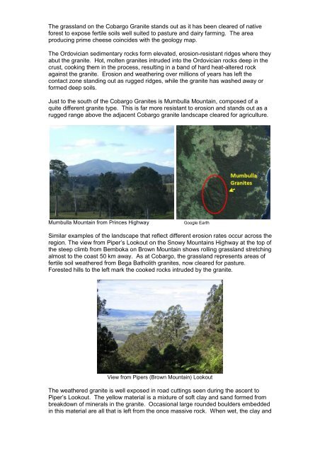
Just to the south <strong>of</strong> the Cobargo <strong>Granite</strong>s is Mumbulla Mountain, composed <strong>of</strong> a<br />
quite different granite type. This is far more resistant to erosion <strong>and</strong> st<strong>and</strong>s out as a<br />
rugged range above the adjacent Cobargo granite l<strong>and</strong>scape cleared for agriculture.<br />
Mumbulla Mountain from Princes Highway<br />
Google Earth<br />
Similar examples <strong>of</strong> the l<strong>and</strong>scape that reflect different erosion rates occur across the<br />
region. <strong>The</strong> view from Piper’s Lookout on the Snowy Mountains Highway at the top <strong>of</strong><br />
the steep climb from Bemboka on Brown Mountain shows rolling grassl<strong>and</strong> stretching<br />
almost to the coast 50 km away. As at Cobargo, the grassl<strong>and</strong> represents areas <strong>of</strong><br />
fertile soil weathered from <strong>Bega</strong> Batholith granites, now cleared for pasture.<br />
Forested hills to the left mark the cooked rocks intruded by the granite.<br />
View from Pipers (Brown Mountain) Lookout<br />
<strong>The</strong> weathered granite is well exposed in road cuttings seen during the ascent to<br />
Piper’s Lookout. <strong>The</strong> yellow material is a mixture <strong>of</strong> s<strong>of</strong>t clay <strong>and</strong> s<strong>and</strong> formed from<br />
breakdown <strong>of</strong> minerals in the granite. Occasional large rounded boulders embedded<br />
in this material are all that is left from the once massive rock. When wet, the clay <strong>and</strong>