9 The Coastal Sandstones - Sapphire Coast
9 The Coastal Sandstones - Sapphire Coast
9 The Coastal Sandstones - Sapphire Coast

You also want an ePaper? Increase the reach of your titles
YUMPU automatically turns print PDFs into web optimized ePapers that Google loves.
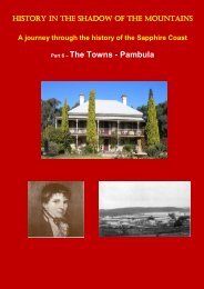
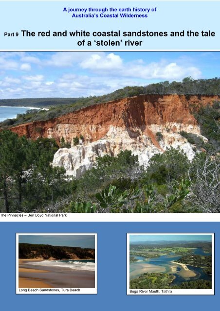
A journey through the earth history ofAustralia’s <strong><strong>Coast</strong>al</strong> WildernessPart 9 <strong>The</strong> red and white coastal sandstones and the taleof a ‘stolen’ river<strong>The</strong> Pinnacles – Ben Boyd National ParkLong Beach <strong>Sandstones</strong>, Tura BeachBega River Mouth, Tathra
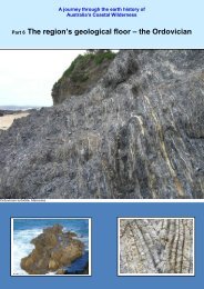
9. <strong>The</strong> red and white coastal sandstones and the taleof a stolen river<strong>The</strong> coastal journey will reveal sandstones that are a lot younger than the Ordovician,Devonian and Cretaceous rocks. Pause at the Tuross Heads turnoff on the PrincesHighway south of Moruya where that first full view of Gulaga can be seen. At this sitethere is a basalt flow sandwiched between two outcrops of sandstone. Minerals in thebasalt have been dated at approximately 31 million years, the middle Tertiary period.Good exposures of the sandstone can be seen from the Michael Lerner Lookout 3kmsouth of Bermagui, forming the cliffs to the south of the town.<strong>The</strong> textbook image of the Tertiary <strong>Sandstones</strong> is at the Pinnacles in the northernsection of Ben Boyd National Park. <strong>The</strong> red iron rich sandstones are from the LongBeach Formation.
<strong>The</strong> Pinnacles, Ben Boyd National Park<strong>The</strong> other formation of older silica rich sandstones can be seen at nearby QuondoloBeach.Google EarthBoth of the coastal sandstone formations are considered to be aggraded deposits.Aggradation is the term used in geology (Wikipedia) for the increase in land elevationdue to the deposition of sediment. Aggradation occurs in areas in which the supplyof sediment is greater than the amount of material that the river system is able totransport away. This clearly reflected a time of very high erosion due to the highrainfall conditions, high sea level, and the creation of the escarpment during theformation of the Tasman Sea.A typical aggraded landscape – debris filled valley
Typical aggradational environments include lowland alluvial rivers, river deltas andalluvial fans. Aggradational environments often undergo slow subsidence under theweight of the accumulating sediment which balances the increase in land surfaceelevation due to this aggradation.<strong>The</strong> timing of the deposition of these two sandstone formations is thought to be quitedifferent. <strong>The</strong>re are uncertainties about the age of the Quondolo Formation butstudies suggest it is Paleocene to Early Eocene, about 55–50 million years ago(Mya).Deposition of the Long Beach Formation is thought to have occurred during theOligocene to Early Miocene (23-30 Mya). This is in accord with the 31 million yeardate for the Coila Basalt, a volcanic flow that is sandwiched between two similarsandstone formations in the Tuross Head part of the region.Aggradation of the south coast mid-Tertiary sandstones is thought to be attributed toan increase in sea level rise during the Oligocene to Early Miocene rise resulting inthe development of coastal barriers of transported sediment at higher levels thantoday.<strong>The</strong> outcrops seen today are a remnant of the original extent of the sandstones. <strong>The</strong>diagram below matches up the contours of current outcrops and remnants that couldconservatively indicate the extent of the aggraded sediments which, in the formingbasins, consolidated into sandstone.
<strong>The</strong> original extent of these sandstones is indicated in red in the images above.When they were laid down in the early to mid-Tertiary, the landscape was covered byrainforest and might have looked like the debris filled valley in the photograph above.Studies have identified four phases of weathering during the Tertiary recognized inthese deposits. Firstly, there is deep kaolinization (formation of soft white clay underhigh rainfall, well preserved in the deeply weathered volcanics (rhyolite) at WhiteRock south of Tathra. This can be seen on the Kangarutha Walking Trail whichextends from near Wallagoot Lake entrance north to Tathra.White Rock, Bournda National Park<strong>The</strong> second phase of weathering was silicification (formation of silica deposits),exemplified in the Quondolo Formation.Whilst the connection is speculative, it is interesting to note that the local depositionand silicification coincided with a major worldwide increase in silica accumulation(following extensive global volcanism), known as the Silica Burp, and a significantglobal warming event (the Paleocene-Eocene <strong>The</strong>rmal Maximum at about 55 Mya).It is also noted that the region was then in the 60º latitudes but it was warm andhumid, with a mean annual temperature of 16-22ºC and precipitation over 1.5 metresper year. <strong>The</strong> vegetation comprised richly mixed rainforests, with plant groupsrelated to those that exist today in the wet tropics rainforests of north Queensland.<strong>The</strong> traveler’s most common reminders of the region’s Gondwanan heritage is thepresence today of the same tree ferns.Tree Fern – Dicksonia antarcticaRough Tree Fern – Cyathea australisWith a touch of botanical irony, the Norfolk Island pines that form an almostcompulsory addition to Australian beach resorts are ancient Gondwanans. <strong>The</strong>irAraucarian relatives would have graced the region’s landscapes in the Cretaceousand early Tertiary periods.
Norfolk Island Pines, BermaguiSilicification was followed by two weathering phases of ferruginization, as recorded inthe Long Beach Formation. Ferruginization is a complex chemical reaction in aweathering soil profile where iron silicates are altered to iron oxide (haematite) andquartz (silica). <strong>The</strong> process is usually indicative of a hot arid climate but it also canoccur in climates that alternated between warm and humid and dry conditions. <strong>The</strong>latter is the likely mechanism for the formation of the south coast red Tertiarysandstones.Ferruginized layer, the Pinnacles, Ben Boyd National Park<strong>The</strong> boundary between the red and the white sandstones that lies within the LongBeach Formation marks the line of an ancient water table.<strong>The</strong> existing outcrops are the eroded remnants of a far larger extent of the LongBeach formation.Australia was a very different place when the Quondolo Formation was deposited,similar to the temperate rainforests of Tasmania today:Tasmanian rainforestAround 41 Mya the continent had finally separated from Antarctica south ofTasmania and accelerated its northward drift. By 30 Mya our region had reachedabout 50º latitude. <strong>The</strong> separation of Antarctica had, for the first time, set up the
How Tathra stole the Bega River<strong>The</strong> beautiful drive from Bega to the coast at Tathra down the Bega River Valleyembodies an interesting mystery. <strong>The</strong> Bega River is present in its grandeur at Begaand immediately downstream from the town. By the time you come to Jellat Jellatthe river has disappeared from view. Jellat Jellat was clearly once the river bed butall that remains are a few lakes and swamps. <strong>The</strong> pre-Miocene mouth of the BegaRiver was at what is now Wallagoot Lake.Jellat Jellat, lower Bega ValleyHorse Shoe Lagoon, lower Bega ValleyWallagoot Lake, Bournda National ParkDuring the period that the Long Beach formation was laid down, the heavyaggradation of sediment in the area now occupied by the <strong>Sapphire</strong> <strong>Coast</strong> RaceCourse, impeded river flow.<strong>Sapphire</strong> <strong>Coast</strong> Race Course, Kalaru<strong>The</strong> river would have backed up in times of flood including backing up into tributarystreams. <strong>The</strong> climate was a lot wetter then. At some stage the backup overtopped
the source of one of the streams, causing the flow down that stream to the coastnorth of Tathra. Each repeat of this flood event would have cut down the new streamuntil it became the main channel. This process is called river ‘capture’.<strong>The</strong> captured river course can be seen in the incised gorge in mid-horizon of thephotograph marked by the dashed line from the heights behind Tathra.Riverview Drive, Tathra<strong>The</strong> process was probably accentuated by the progressive drop in sea level asAntarctica started to accumulate ice. This steady drop would have lowered the riverbase line and thus increased water flow speed and erosive power. This producedthe valleys in the lower reaches of the region’s waterways, for example PambulaLake.Pambula Lake
One interesting observation one can draw from this process is the amazing age ofthe region’s landscape. Clearly, there has been little topographic change in the last30 million years.This age is worth reflecting (and speculating) on. <strong>The</strong> first period after the formationof the Tasman Sea was a time of huge erosion. <strong>The</strong> interesting point about the BegaValley is not so much what is here, but what is not here. Given that the landscapewas stable after 30 Mya and the escarpment formed as a hinge on the down slopingCretaceous Plain, a huge amount of material has been eroded away in the earlyyears of the Tasman Sea. What is missing can be envisaged from almost anywherein the valley, for example from Pipers (Brown Mountain) Lookout.<strong>The</strong> location and dates of the surfaces are quite speculative. <strong>The</strong>se old surfaces andprobable changes in erosion rates appear across the landscape in a large number ofplaces including on the flanks of the mountains.Today’s coastal sandstones would only represent a fraction of this eroded material.<strong>The</strong> rest must be off the continental shelf, awaiting investigation.
<strong>The</strong> Montreal GoldfieldsOne interesting Tertiary sandstone area worth a visit is the Montreal Goldfields 5 kmnorth of Bermagui (see http://www.montrealgoldfield.org.au/getting_here.html )Montreal Goldfield, Wallaga LakeAlluvial gold was first found in the nearby region (Dignams Creek) in 1860. <strong>The</strong> mainsource was vein deposits of gold in the high slopes and crest of Mt Dromedary.<strong>The</strong>se were worked in tunnel and sluicing operations in three main mines over theperiod 1878-1920. Whilst rainforest has reclaimed the highly disturbed crest of themountain the impact of the mining can still be clearly seen.Erosion of the igneous intrusion washed gold into the creek systems and alluvial goldwas found in a number of locations including Dignams Creek. Over 1880 to 1883 asignificant alluvial gold site (Montreal Goldfield) was opened up in the coastal areanorth of Bermagui.<strong>The</strong> gold is found in an old river bed under a thick aggraded barrier of Tertiarysandstone, probably dating from the same time as the Bermagui sandstone (about30 million years ago). <strong>The</strong> sandstone includes a considerable amount of quartzduricrust. This was a silica rich crust precipitated in the Paleocene – Eocenerainforest soil profiles during the region’s period of warm humid climate and heavyrainfall (1.5 metres pa). At nearby sites the finer grained component in thesandstone has been eroded out leaving the blocks of quartz duricrust accumulated inheaps. <strong>The</strong> best example is in the cutting on the Wallaga Lake Road near theBermagui-Cobargo intersection just north of Bermagui.Bermagui-Cobargo Road intersection<strong>The</strong> cap sits on a highly eroded profile of Ordovician sandstone.