Kinematics of the Greater Himalayan sequence, Dhaulagiri Himal ...
Kinematics of the Greater Himalayan sequence, Dhaulagiri Himal ...
Kinematics of the Greater Himalayan sequence, Dhaulagiri Himal ...

Create successful ePaper yourself
Turn your PDF publications into a flip-book with our unique Google optimized e-Paper software.
1142<br />
1143<br />
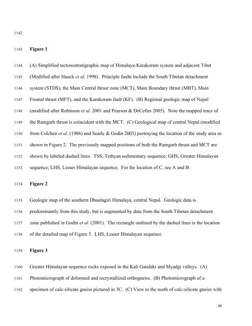
Figure 1<br />
1144<br />
1145<br />
1146<br />
1147<br />
1148<br />
1149<br />
1150<br />
1151<br />
1152<br />
1153<br />
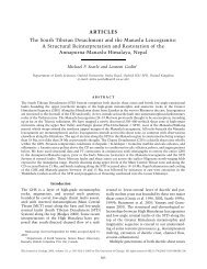
(A) Simplified tectonostratigraphic map <strong>of</strong> <strong>Himal</strong>aya-Karakoram system and adjacent Tibet<br />
(Modified after Hauck et al. 1998). Principle faults include <strong>the</strong> South Tibetan detachment<br />
system (STDS), <strong>the</strong> Main Central thrust zone (MCT), Main Boundary thrust (MBT), Main<br />
Frontal thrust (MFT), and <strong>the</strong> Karakoram fault (KF). (B) Regional geologic map <strong>of</strong> Nepal<br />
(modified after Robinson et al. 2001 and Pearson & DeCelles 2005). Note <strong>the</strong> mapped trace <strong>of</strong><br />
<strong>the</strong> Ramgarh thrust is coincident with <strong>the</strong> MCT. (C) Geological map <strong>of</strong> central Nepal (modified<br />
from Colchen et al. (1986) and Searle & Godin 2003) portraying <strong>the</strong> location <strong>of</strong> <strong>the</strong> study area as<br />
shown in Figure 2. The previously mapped positions <strong>of</strong> both <strong>the</strong> Ramgarh thrust and MCT are<br />
shown by labeled dashed lines. TSS, Tethyan sedimentary <strong>sequence</strong>; GHS, <strong>Greater</strong> <strong><strong>Himal</strong>ayan</strong><br />
<strong>sequence</strong>; LHS, Lesser <strong><strong>Himal</strong>ayan</strong> <strong>sequence</strong>. For <strong>the</strong> location <strong>of</strong> C, see A and B.<br />
1154<br />
Figure 2<br />
1155<br />
1156<br />
1157<br />
1158<br />
Geologic map <strong>of</strong> <strong>the</strong> sou<strong>the</strong>rn <strong>Dhaulagiri</strong> <strong>Himal</strong>aya, central Nepal. Geologic data is<br />
predominantly from this study, but is augmented by data from <strong>the</strong> South Tibetan detachment<br />
zone published in Godin et al. (2001). The rectangle outlined by <strong>the</strong> dashed lines is <strong>the</strong> location<br />
<strong>of</strong> <strong>the</strong> detailed map <strong>of</strong> Figure 5. LHS, Lesser <strong><strong>Himal</strong>ayan</strong> <strong>sequence</strong>.<br />
1159<br />
Figure 3<br />
1160<br />
1161<br />
1162<br />
<strong>Greater</strong> <strong><strong>Himal</strong>ayan</strong> <strong>sequence</strong> rocks exposed in <strong>the</strong> Kali Gandaki and Myadgi valleys. (A)<br />
Photomicrograph <strong>of</strong> deformed and recrystallized orthogneiss. (B) Photomicrograph <strong>of</strong> a<br />
specimen <strong>of</strong> calc-silicate gneiss pictured in 3C. (C) View to <strong>the</strong> north <strong>of</strong> calc-silicate gneiss with<br />
48