2012 AND BEYOND - London & Partners
2012 AND BEYOND - London & Partners
2012 AND BEYOND - London & Partners

Create successful ePaper yourself
Turn your PDF publications into a flip-book with our unique Google optimized e-Paper software.
30 Section 06: Maps 31<br />
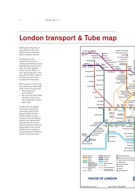
<strong>London</strong> transport & Tube map<br />
Getting around <strong>London</strong> is<br />
easy, thanks to the city’s<br />
extensive and interlinked<br />
public transport network.<br />
The bedrock of the<br />
network is the <strong>London</strong><br />
underground railway service,<br />
affectionately known as the<br />
Tube, The map opposite<br />
shows how the Tube’s 11<br />
lines reach every part of the<br />
city, with the 250+ stations<br />
linking every community,<br />
business and retail area.<br />
But the Tube is not the only<br />
way citizens and visitors get<br />
from A to B. They also use:<br />
• The Overground<br />
train network;<br />
• Bus services which reach<br />
into every community;<br />
• Plus the familiar <strong>London</strong><br />
black cabs.<br />
<strong>London</strong> also has regular<br />
river ferries transferring<br />
commuters and tourists<br />
along the River Thames.<br />
Further afield, the city is<br />
served by five international<br />
airports, and national and<br />
international rail services.<br />
Ongoing enhancements are<br />
being made to the overall<br />
infrastructure, including a<br />
Crossrail project linking the<br />
city on its east-west axis.