Subglacial lake in the glacier of Tete Rousse (Mont Blanc area ...
Subglacial lake in the glacier of Tete Rousse (Mont Blanc area ...
Subglacial lake in the glacier of Tete Rousse (Mont Blanc area ...

You also want an ePaper? Increase the reach of your titles
YUMPU automatically turns print PDFs into web optimized ePapers that Google loves.
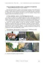
<strong>Subglacial</strong> <strong>lake</strong> <strong>in</strong> <strong>the</strong> <strong>glacier</strong> <strong>of</strong> <strong>Tete</strong> <strong>Rousse</strong><br />
(<strong>Mont</strong> <strong>Blanc</strong> <strong>area</strong>, France)<br />
C. V<strong>in</strong>cent (1), A. Legchenko (2)<br />
M. Descloitres (2), S. Garambois (3),<br />
(1) Laboratoire de Glaciologie et Géophysique de l’Environnement (LGGE),<br />
(2) Laboratoire d’étude des Transferts en Hydrologie en Environnement (LTHE)<br />
(3) Laboratoire de Géophysique Interne et Tectonophysique (LGIT)<br />
20 Avril 2011<br />
Grenoble
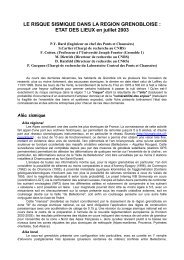
11 July,<br />
1892<br />
Town <strong>of</strong> Sa<strong>in</strong>t<br />
Gervais<br />
devastated<br />
175 fatalities
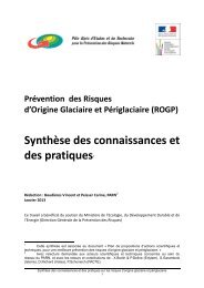
Orig<strong>in</strong> : outburst flood from a subglacial cavity
2 cavities
3240<br />
3220<br />
Altitude (m)<br />
3200<br />
3180<br />
3160<br />
3140<br />
Upper<br />
Cavité<br />
Sup.<br />
cavity<br />
3120<br />
Conduit<br />
Cavité <strong>in</strong>f.<br />
Lower cavity<br />
3100<br />
0 20 40 60 80 100 120 140 160 180 200<br />
Distance (m)
3240<br />
3220<br />
Altitude (m)<br />
3200<br />
3180<br />
3160<br />
3140<br />
Upper<br />
Cavité<br />
Sup.<br />
cavity<br />
3120<br />
Conduit<br />
Cavité <strong>in</strong>f.<br />
Lower cavity<br />
3100<br />
0 20 40 60 80 100 120 140 160 180 200<br />
Distance (m)<br />
200 000 m 3 <strong>of</strong> water<br />
> 1 000 000 m 3 <strong>of</strong> mud at St Gervais
Tunnels drilled <strong>in</strong><br />
1899 and 1904
- Is this tunnel needed to prevent from a new outburst<br />
flood?<br />
- Could this <strong>glacier</strong> cause ano<strong>the</strong>r outburst flood ?
2007/2008<br />
Glaciological studies:<br />
. Topographic measurements<br />
. Radar measurements<br />
. Temperature measurements<br />
. Mass balance measurements
0 20 40 60 80 100 120 140 160<br />
3170<br />
3160<br />
Rive Droite<br />
Rive Gauche<br />
3170<br />
3160<br />
3150<br />
3150<br />
3140<br />
3130<br />
1 402 403 404 405 406 407 408 409 410 411 412 413<br />
414<br />
3140<br />
3130<br />
Altitude<br />
3120<br />
415 416 417 418 419 420 421 422423 424 3070<br />
Galerie<br />
3120<br />
3110<br />
3110<br />
3100<br />
3100<br />
3090<br />
3090<br />
3080<br />
3070<br />
Pr<strong>of</strong>il 4<br />
3080<br />
0 20 40 60 80 100 120 140 160<br />
Distance<br />
Galerie<br />
First conclusion: <strong>the</strong> tunnel <strong>of</strong> 1904 is probably unuseful to<br />
prevent from a new outburst flood .
Second conclusion: <strong>the</strong> radar measurements showed a<br />
zone (volume ) with an anomaly.<br />
.
Water ? Rocks <strong>in</strong>to <strong>glacier</strong> ?
Présentation au conseil municipal de Sa<strong>in</strong>t<br />
Gervais le 4 août 2008<br />
. Présentation des résultats<br />
. Recommandation de faire des forages<br />
pour élucider cette zone d’anomalie
Sept 2009, nouvelle étude:<br />
Prospection géophysique par la méthode de résonance<br />
magnétique<br />
(Laboratoire d’Hydrologie de Grenoble, LTHE)
Volume d’eau de 65 000 m3<br />
Rapport à la préfecture le 4 mars 2010
Réunion Préfecture le 24 mars 2010:<br />
- Résultats de la prospection RMP de septembre 2009<br />
- Propositions d’<strong>in</strong>vestigations supplémentaires (avant août<br />
2010):<br />
. Campagnes de terra<strong>in</strong> RMP et radar pour préciser la localisation<br />
du volume d’eau liquide<br />
. Réaliser des forages pour vérifier directement la présence d’eau<br />
à la base du <strong>glacier</strong>
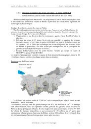
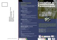
Mai 2010: nouvelles mesures radar
2105200<br />
Glacier de Tête <strong>Rousse</strong><br />
2105150<br />
23<br />
22<br />
2105100<br />
2105050<br />
2105000<br />
21<br />
11<br />
18<br />
9<br />
8<br />
10<br />
4<br />
7<br />
8<br />
9<br />
20<br />
19<br />
7<br />
13 3 2<br />
1<br />
11 12 15<br />
14<br />
6 5<br />
16<br />
10<br />
21<br />
17<br />
17 18<br />
20<br />
19<br />
22<br />
2104950<br />
12 23<br />
11<br />
14 10<br />
13<br />
9 15 16 17 18 19 20<br />
2104900<br />
Ancien<br />
Refuge<br />
Cabane<br />
RTM<br />
Ancienne<br />
Galerie<br />
Galerie<br />
de 1904<br />
0 20 40 60 80 100 120 140 160 180 200<br />
2104850<br />
947700 947750 947800 947850 947900 947950 948000 948050 948100 948150 948200 948250 948300
20 drill<strong>in</strong>g holes have been<br />
performed between <strong>the</strong> 29 <strong>of</strong><br />
June and <strong>the</strong> 8 <strong>of</strong> July, 2010<br />
us<strong>in</strong>g a <strong>the</strong>rmal drill<strong>in</strong>g<br />
mach<strong>in</strong>e,
17<br />
Forage 2<br />
Forage 20<br />
2<br />
20 7 16<br />
Forage 16<br />
Forage 10<br />
5<br />
10<br />
Forage 17<br />
Forage 5<br />
. 20 drill<strong>in</strong>g holes<br />
. Maximum thickness is 76 m
17<br />
Forage 2<br />
Forage 20<br />
2<br />
20 7 16<br />
Forage 16<br />
Forage 10<br />
5<br />
10<br />
Forage 17<br />
Forage 5<br />
- Camera<br />
-Water pressure sensors<br />
- Ice temperature sensors<br />
(Thermistors)
We found a subglacial water reservoir at <strong>the</strong> bottom <strong>of</strong> 6 boreholes<br />
(Video)
At 2 boreholes, artesian outpour<strong>in</strong>gs 10 cm higher than <strong>the</strong> ice surface<br />
occured when <strong>the</strong> subglacial cavity was reached
Heights <strong>of</strong> <strong>the</strong> subglacial cavity<br />
2105200<br />
2105150<br />
22<br />
23<br />
18,7 m<br />
Glacier de Tête <strong>Rousse</strong><br />
29 m<br />
15 m<br />
2105100<br />
2105050<br />
2105000<br />
21<br />
11<br />
18<br />
9<br />
8<br />
10<br />
4<br />
7<br />
8<br />
9<br />
20<br />
19<br />
7<br />
13 3 2<br />
1<br />
11 12 15<br />
14<br />
6 5<br />
16<br />
10<br />
21<br />
17<br />
17 18<br />
20<br />
19<br />
22<br />
2104950<br />
2104900<br />
8.4 m<br />
Ancien<br />
Refuge<br />
12 23<br />
14 11 10<br />
13<br />
9<br />
15 16 17 18 19 20<br />
Cabane<br />
RTM<br />
Ancienne<br />
Galerie<br />
20 m<br />
Galerie<br />
de 1904<br />
0 20 40 60 80 100 120 140 160 180 200<br />
2104850<br />
947700 947750 947800 947850 947900 947950 948000 948050 948100 948150 948200 948250 948300<br />
12.2 m
3190<br />
Surface de neige (juillet 2010)<br />
3180<br />
3170<br />
3160<br />
Altitude (m)<br />
3150<br />
3140<br />
3130<br />
3120<br />
3110<br />
3100<br />
3090<br />
0 50 100 150 200<br />
Distance (m)
The hydrostatic pressure exceeded <strong>the</strong> ice pressure<br />
due to <strong>the</strong> weight <strong>of</strong> <strong>the</strong> ice column<br />
Snout<br />
<strong>of</strong> <strong>the</strong> <strong>glacier</strong><br />
Lower Cavity<br />
<strong>in</strong> 1892<br />
Upper<br />
Cavity<br />
<strong>in</strong> 1892<br />
18<br />
Longitud<strong>in</strong>al section<br />
Tunnel 1904<br />
Tunnel 1899<br />
0 20 40 60 80 100 120 140 160 180 200 m
We could expect that <strong>the</strong> water conta<strong>in</strong>ed <strong>in</strong> <strong>the</strong><br />
<strong>glacier</strong> would be released suddenly<br />
Snout<br />
<strong>of</strong> <strong>the</strong> <strong>glacier</strong><br />
Lower Cavity<br />
<strong>in</strong> 1892<br />
Upper<br />
Cavity<br />
<strong>in</strong> 1892<br />
18<br />
Longitud<strong>in</strong>al section<br />
Tunnel 1904<br />
Tunnel 1899<br />
0 20 40 60 80 100 120 140 160 180 200 m
Forage 17<br />
The public authorities have been warned immediatly<br />
(13 July, 2010):<br />
It has been decided to dra<strong>in</strong> <strong>the</strong> subglacial <strong>lake</strong> as soon as<br />
possible, because 3000 people were threatened <strong>in</strong> <strong>the</strong> valley.
Alert system set up to<br />
trigger <strong>of</strong>f fire sirens <strong>in</strong> <strong>the</strong><br />
villages downstream
The subglacial <strong>lake</strong> has been dra<strong>in</strong>ed artificially us<strong>in</strong>g<br />
down hole pumps between August and October 2010
Risk <strong>of</strong> collapse with <strong>the</strong> decrease <strong>of</strong> water pressure ?
Sonar measurements to obta<strong>in</strong> <strong>the</strong> geometry <strong>of</strong> <strong>the</strong><br />
subglacial cavity (1st September)<br />
(see 3D image)
Elmer/Ice code<br />
(Ice flow modell<strong>in</strong>g)<br />
(Gagliard<strong>in</strong>i et al., 2010, Durand<br />
et al., 2009, Gagliard<strong>in</strong>i and<br />
Zw<strong>in</strong>ger, 2008, Zw<strong>in</strong>ger et al.,<br />
2007 )<br />
Result:<br />
max tensile stress : 0.2 MPa +/-0.1 MPa<br />
Tensile strength known for temperate ice :<br />
0.8 +/- 0.4 MPa
The risk <strong>of</strong> cavity ro<strong>of</strong> collapse was estimated<br />
to be low but could not be completely<br />
excluded
Analyse de la résistance de la voûte par<br />
modélisation numérique<br />
Résultat:<br />
Contra<strong>in</strong>te de traction modélisée proche de la valeur<br />
de la résistance à la traction de la glace<br />
Réunion à la mairie de sa<strong>in</strong>t Gervais le 8<br />
septembre<br />
« …on doit considérer que le risque d’effondrement du toit de la cavité ou<br />
d’une partie du toit de la cavité, en cours de vidange, est faible mais<br />
pas nul. »
For preventive measure, we suggested :<br />
. To measure <strong>the</strong> vertical and horizontal velocities from a<br />
network <strong>of</strong> stakes, each day, from topographic<br />
measurements<br />
. To observe <strong>the</strong> <strong>glacier</strong> surface and craks
Many questions for <strong>the</strong> scientists:<br />
-What is <strong>the</strong> cause <strong>of</strong> water accumulation <strong>in</strong>side this<br />
<strong>glacier</strong> ?<br />
- Will this subglacial <strong>lake</strong> water form aga<strong>in</strong> <strong>in</strong> <strong>the</strong><br />
future ?
Conclusions:<br />
- The first time that a subglacial <strong>lake</strong> has been detected <strong>in</strong> an<br />
alp<strong>in</strong>e <strong>glacier</strong><br />
- The water accumulation is due to <strong>the</strong>rmal regime<br />
- The rate <strong>of</strong> water accumulation rema<strong>in</strong>s unknown<br />
- A lot <strong>of</strong> work is needed aga<strong>in</strong> to reply to all questions….<br />
has
has e<br />
Thank you for your attention….