View PDF - Travel South Yorkshire
View PDF - Travel South Yorkshire
View PDF - Travel South Yorkshire

You also want an ePaper? Increase the reach of your titles
YUMPU automatically turns print PDFs into web optimized ePapers that Google loves.
Responsible Walking<br />
This walk uses just a few of our<br />
many rights of way to access<br />
and enjoy the countryside.<br />
A right of way is not owned by<br />
the council, it is a right to pass<br />
over private land. When you<br />
go out please remember that<br />
almost all the land you cross<br />
is in private ownership, and<br />
someone’s livelihood will<br />
depend on the crops and<br />
livestock there. Our countryside<br />
is not just a beautiful place, but<br />
a working environment, please<br />
play your part by keeping it tidy<br />
for the people who walk and<br />
work there tomorrow.<br />
Take a responsible attitude<br />
into the countryside, leave<br />
only footprints and take<br />
only photographs.<br />
Follow the Country Code,<br />
happy walking!<br />
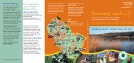
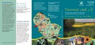
The Laughton<br />
walk around<br />
Roche Abbey<br />
This doorstep walk follows<br />
the same route as walk 1<br />
– the Spire Walk – but the<br />
description has been modified<br />
to allow its use directly from<br />
Roche Abbey.<br />
How do I get there?<br />
The Abbey has good bus links<br />
to other areas in the Borough,<br />
for up to date information call<br />
the <strong>Travel</strong>ine on 01709 515151<br />
or visit www.sypte.co.uk<br />
for timetables.<br />
The walk starts at the Blyth<br />
Road – Gypsy Lane bus stop.<br />
Something to think about<br />
This walk would not be<br />
possible without the help of<br />
local people, landowners and<br />
farmers. We would like to<br />
take this opportunity to<br />
thank them, and would<br />
particularly like to thank<br />
Mr Turner of Manor Farm,<br />
Laughton and Mr Hinchliffe<br />
of Grange Farm, Wickersley<br />
for all their help in carrying<br />
out works to this walk.<br />
If you enjoyed this walk you<br />
may wish to find out more<br />
about Laughton in the<br />
Countryside Departments<br />
excellent Laughton en le<br />
Morthen Historic Walk leaflet.<br />
Contact 01709 822438 for<br />
a copy.<br />
Any enquiries please ring<br />
01709 822168<br />
Remember to keep a track<br />
of where you are in the<br />
description, occasionally<br />
waymarks get vandalised<br />
and we may not have<br />
had time to replace it.<br />
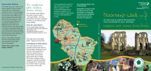
Key<br />
2<br />
Walk No: 2<br />
Roche Abbey<br />
2<br />
Produced on Recycled Paper<br />
Design & production by the Design Studio, RMBC 01709 823679<br />
Doorstep Walk No:2<br />
An easy way to explore the beautiful,<br />
local countryside on your ‘doorstep’.<br />
Laughton walk around Roche Abbey<br />
Produced by the Rights of Way Team.
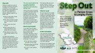
Doorstep Walk<br />
Short, Easy to<br />
follow and local<br />
Enjoy a short walk in the<br />
countryside around the<br />
Abbey ruins.<br />
■ This walk will take about<br />
2 hours, it has a small<br />
easy uphill climb of about<br />
15 minutes, the rest is<br />
fairly flat.<br />
■ It passes an historic church<br />
and the remains of a castle<br />
before crossing rolling<br />
farmland, passing through<br />
a fine wood and finally<br />
along a valley with<br />
excellent views.<br />
■ You do not need to read<br />
a map.<br />
■ You do not need fancy<br />
equipment.<br />
Just follow the<br />
Doorstep waymark<br />
Motte and Bailey Castle<br />
Just to the west of the Church are the earthworks known as<br />
Castle Hill.These consist of a round mound approximately 370<br />
feet in diameter and a rectangular area known locally as the<br />
‘Hall Yard’.Although it is called a castle the mound is<br />
pre-Norman and may possibly be the site of the hall of Edwin,<br />
the Saxon Earl of Mercia.<br />
(The image is a postcard from the turn of the 19th century.)<br />
The Laughton walk around Roche Abbey<br />
6<br />
The route now<br />
bears right uphill along<br />
the road for about 20 metres<br />
before heading left down<br />
Brookhouse Lane, take special care<br />
on this short section of road. Soon<br />
you will see a path on your right<br />
heading downhill, follow this past<br />
the <strong>Travel</strong>lers Rest and, at the<br />
roadside turn right along the<br />
road, again take special care<br />
along this short section<br />
of road.<br />
At the side of the<br />
7<br />
Immediately after<br />
brook turn left and follow<br />
passing a small group of<br />
the beautiful tree lined valley<br />
houses on your left you will see<br />
above Colonel’s Holt, cross a ditch<br />
a path heading alongside the<br />
and enter Kings Wood for the second<br />
houses, follow this uphill to the edge time on your walk. Follow the path by<br />
of the railway embankment. Turn right, the side of the brook and then cross the<br />
passing an outbuilding on your right and bridge and boardwalk. Stay on the path<br />
you will soon reach Hooton Lane. as it heads slightly uphill and soon you<br />
Carefully cross the road and follow the will come to a fork in the route<br />
path opposite, behind houses and into – you have been here before, turn<br />
fields. The path follows the side of<br />
left and follow the path back<br />
the railway for some time before<br />
through the wood and abbey<br />
a sign points across field<br />
to the start of the walk.<br />
and downhill, follow<br />
this path.<br />
5<br />
Stay on the path<br />
at the edge of fields and<br />
eventually you will come to a<br />
large stone wall, which runs<br />
alongside the path. Cross the stile<br />
and keep going forwards, ignoring any<br />
side paths. Here you will pass near All<br />
Saints Church, look closely and you will<br />
see a mound in the foreground, this is all<br />
that remains of a Motte and Bailey<br />
castle (see sidebar). Keep on the path<br />
at the side of the field, passing<br />
under some power cables<br />
before reaching<br />
Rotherham Lane. 4<br />
At the road turn<br />
right up the High Street,<br />
and, at the crossroads, turn<br />
left down School Road. After a<br />
while you will see the school<br />
(Laughton Infant and Primary<br />
School), a large red brick building.<br />
Follow the narrow path up the<br />
steps by the far side of the<br />
school, and follow the path<br />
around the playing<br />
fields.<br />
8<br />
3<br />
Carry on along the<br />
path, crossing over a field<br />
boundary at one point. The path<br />
dips downhill, stay on the field edge,<br />
and soon the path enters a hedge lined<br />
track. The track bears left and soon<br />
another open track appears on your right,<br />
follow this heading directly for the church<br />
in the distance. The path stays on field<br />
edges, keep heading for the church and<br />
soon you will cross a small field.<br />
Immediately after this the path enters<br />
a large field, turn left uphill and<br />
head through the beer garden<br />
of the St Leger Arms.<br />
1<br />
Start at the<br />
bus stop on the A634<br />
(the Blyth Road – Gypsy<br />
Lane stop) and follow the<br />
road signs for Roche<br />
Abbey, which lead down a<br />
narrow lane, turns and<br />
reaches the main<br />
abbey car park.<br />
From the main abbey<br />
car park follow the path<br />
towards the abbey ruins, passing to<br />
the left of the visitor centre, after a short<br />
distance the path turns right and heads<br />
behind the abbey ruins before eventually<br />
entering Kings Wood (see sidebar). Follow the<br />
path as it heads slightly uphill until you come to a<br />
fork in the route, bear left heading uphill.<br />
At the top of the hill the path enters a large field,<br />
head right following the edge of the field and<br />
keep to the top of the hill.<br />
Pause for a while to look at the views – the spire<br />
in the distance belongs to All Saints Church,<br />
the walk will pass by the side of it before<br />
heading back towards the abbey and<br />
passing through the fields<br />
directly below you.<br />
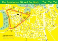
The map used is based on the Ordnance Survey 1:25,000 mapping with the sanction of the controller of Her Majesty’s Stationery Office. Crown Copyright Reserved. LAO76287<br />
2<br />
King’s Wood<br />
These woods are a Site of Special Scientific Interest, they<br />
represent one of the country's best and largest lowland<br />
broad leaved woodland on the Magnesian limestone.<br />
They are abundant in ancient woodland species including<br />
wych elm and sessile oak as well as lily-of-the-valley,<br />
yellow star of bethlehem and toothwort.<br />
The wood is a fragile environment, please respect it for<br />
the enjoyment of others who follow in your footsteps.<br />
The area around Roche Abbey<br />
has some great walking country,<br />
this route is fairly easy, the time<br />
is based on an adult walking<br />
fairly slowly and having a few<br />
good rests. There is a short<br />
section which is seasonally<br />
muddy at Colonels Holt, be sure<br />
you have boots, not trainers.<br />
Remember, it can get muddy<br />
underfoot at any time of year,<br />
don’t forget to dress for typical<br />
English weather. There<br />
are 3 pubs on the route, and<br />
Roche Abbey lodge has pop and<br />
snacks but is only open from<br />
April to October.<br />
For more details check out<br />
our web-page on<br />
www.rotherham.gov.uk<br />
All paths around Laughton and<br />
Roche Abbey are shown clearly<br />
on the OS Explorer Map 279<br />
Doncaster. Why not pick up a<br />
copy at your local bookshop and<br />
devise your own walks.