View PDF - Travel South Yorkshire
View PDF - Travel South Yorkshire
View PDF - Travel South Yorkshire
- No tags were found...

You also want an ePaper? Increase the reach of your titles
YUMPU automatically turns print PDFs into web optimized ePapers that Google loves.
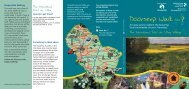
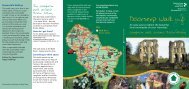
Responsible WalkingThis walk uses just a few ofour many rights of way toaccess and enjoy thecountryside. A right of way isnot owned by the council, itis a right to pass over privateland. When you go out pleaseremember that almost all theland you cross is in privateownership, and someone’slivelihood will depend on thecrops and livestock there.Our countryside is not justa beautiful place, but aworking environment, pleaseplay your part by keeping ittidy for the people who walkand work there tomorrow.Take a responsible attitudeinto the countryside, leaveonly footprints and takeonly photographs.Follow the Country Code,happy walking!The WaleswoodWalk aroundRother ValleyHow do I get there?Aston has good bus linksto other areas in theBorough, for up to dateinformation call the<strong>Travel</strong>ine on 01709 515151or visit www.sypte.co.ukfor timetables.The walk starts at RotherValley Park. From the busstopfollow the access roadinto the park until you reachthe visitor centre, this linkputs about another hour onthe walk in total.Something to think aboutMany of the paths to thenorth of Rother Valley arenewly restored, up untilrecently the whole area wasan open-cast coal site.Again the walk would not bepossible without the abundanthelp and enthusiasm oflandowners and local people.All paths around Aston andRother Valley Park are shownclearly on the OS ExplorerMap 278 Rotherham. Whynot pick up a copy at yourlocal bookshop and deviseyour own walks.4Any enquiries please ring01709 822168Remember to keep a trackof where you are in thedescription, occasionallywaymarks get vandalisedand we may not havehad time to replace it.Key4Walk No: 4The Waleswood Walkaround Rother ValleyProduced on Recycled PaperDesign & production by the Design Studio, RMBC 01709 823679Doorstep Walk No:4An easy way to explore the beautiful,local countryside on your ‘doorstep’.The Waleswood Walk around Rother ValleyIncludes an Aston – Rother Valley Link WalkProduced by the Rights of Way Team.
Doorstep WalkShort, Easy tofollow and localTake a walk throughthe countryside atRother Valley Park.■ This walk will take about1 1 /2 hours, and is almostentirely off public road.It also has a much shortercircuit and short-cut.■ The award winning RotherValley Park is the base ofour walk, this route linksinto the rolling farmlandabove the valley and hasa link into nearby Astonwhere there are shopsand pubs.■ You do not need to reada map.■ You do not need fancyequipment.Just follow theDoorstep waymarkAbundant BirdlifeThe park is abundant in woodland, grassland and hedgerow, ensuringa large amount of birdlife. Keep an eye out and you may see jay,sparrowhawk, woodpecker, little owl, green finch and goldfinch.With 170 acres of open water within the park Rother Valley offersan ideal habitat for the many species of waterfowl such as teal,tufted duck, widgeon and greylag geese.Rother Valley Park - HistoryRother Valley Country Park was first suggested in the1960's as the areas of Mosborough, Beighton and Sothallbegan to expand.Open-casting of the 300 hectare site began in 1976, andremoved a total of 1.7 million tonnes of high quality coal,the last being taken off site in 1981.In total 480 000 trees and shrubs were planted on site andBedgreave Mill together with its associated farm buildings,was restored to form a centrepiece to the park.2Keep following thepath ahead, you arefollowing part of the Trans PennineTrail, a 350 mile route from <strong>South</strong>portto Hull, this route forms part of a muchlarger European route called the E8 routewhich links the West Coast of Ireland toIstanbul. Some 20 miles of the Trans PennineTrail crosses Rotherham, with many potentialshorter link walks such as the one you arefollowing. Stay on the path above the river untilyou see a wood ahead on your right, here thetrack joins an embankment and bendsslightly left. Just before this go right,down a very short bank and thenimmediately right againto follow a path whichheads uphill.The Waleswood Walk around Rother Valley3Keep goingstraight and after a veryshort time the path levels outwith the wood on your right.Soon you will come to a track.To have a side trip to Aston where thereis a pub and shops, head left for about50 metres, then right across a small archedfootbridge. Then go straight uphill,crossing the railway and road via bridges,eventually you will reach Mansfield Road.Carefully cross this and headstraight-ahead up Lodge Lane wherethere is a pub and shops.Retrace your steps to returnto the trail.1aTo take theshortcut lookout fora path on your rightmore or less opposite thesuspension bridge, followthis path uphill by the edgeof the plantation andrejoin the main routeat Point 4.14Turn rightand follow the track,which heads steadilyuphill, (for those whohave taken the shortcut yourejoin the walk here). Stayon the track, whicheventually joins a road,take care on thisshort section.Start at theVisitor Centre in theRother Valley Park (seesidebar), head out onto theaccess road, go right and thencross the road bridge. Once acrossturn left and follow the broadpath with the river immediatelyon your left. After a while youwill see a large suspensionfootbridge ahead onyour left.To join the walk fromAston start at the AughtonLane/Worksop Road junction (wherethere are several shops) head downhillalong Worksop Road until you pass AstonJunior and Infant School on your left. Here headleft down Lodge Lane until you reach MansfieldRoad, cross this (taking care as the road is busy)and head down Brookhouse Lane, keep headingstraight as the lane leaves the industrial units behindand crosses the road and railway. The path headsstraight downhill until you reach some ponds, keepgoing straight, crossing a small arched footbridgeand turn left. Follow the description from‘Stay on the track…’ (below left) but when youreach the road bridge at point 5 do notcross it, instead turn right and headalong the track, then follow thedescription back to thearched footbridge.5Passing a farmon your right the roadturns right and slightlydownhill before coming to acorner where there are a couplemore houses. Just before these isa path on your right, follow thisalong a track, this heads gentlyuphill, then finally steeplydown, back into the park.The visitor centre is toyour right, just overthe bridge.The map used is based on the Ordnance Survey 1:25,000 mapping with the sanction ofthe controller of Her Majesty’s Stationery Office. Crown Copyright Reserved. LAO76287Rother Valley Country Park is veryaccessible, and links to the TransPennine Trail, the National CycleNetwork and the Cuckoo Way,a 42-mile linear route along theChesterfield Canal. For copies ofany of these publications contactthe Rights of Way team (01709)822168. The time for this walk isbased on an adult walking fairlyslowly and having a few goodrests. As ever, don’t forget to dressfor typical English weather, it canget muddy underfoot at any timeof year. The route has links to pubsand shops at Aston, and there is acafe at Rother Valley Park.For more details, downloads ofalternative route descriptions andthemed guides check out ourweb-page onwww.rotherham.gov.ukA FamilyFriendly WalkThis easy walk passes throughrolling farmland and parkland andoffers an interesting easy routeaway from the busy park. Theshort route should take aboutforty five minutes. Part of the walkcan get boggy, please make surechildren have suitable footwear.Allow about 2 hours for smallerlegs to complete the whole walk.