National Report of SWEDEN to the NKG General ... - Lantmäteriet
National Report of SWEDEN to the NKG General ... - Lantmäteriet
National Report of SWEDEN to the NKG General ... - Lantmäteriet

You also want an ePaper? Increase the reach of your titles
YUMPU automatically turns print PDFs into web optimized ePapers that Google loves.
2<br />
different network RTK s<strong>of</strong>tware and<br />
<strong>the</strong> work was performed by<br />
Lantmäteriet in collaboration with<br />
KMS 6<br />
and <strong>the</strong> Norwegian Mapping<br />
Authority.<br />
The processing <strong>of</strong> <strong>the</strong> <strong>NKG</strong> 2003 GPS<br />
Campaign has been co-ordinated from<br />
Lantmäteriet during 2004, with a final<br />
report completed in 2005 (Jivall et al,<br />
2005 and Jivall et al, 2006). The<br />
purposes <strong>of</strong> <strong>the</strong> campaign were <strong>to</strong><br />
develop a unified ETRS 89 reference<br />
frame on <strong>the</strong> cm level for <strong>the</strong> Nordic<br />
area and <strong>to</strong> develop transformation<br />
strategies between ITRF 7<br />
and <strong>the</strong><br />
national realisations <strong>of</strong> ETRS 89. The<br />
GPS observations were carried out<br />
from September 28 th <strong>to</strong> Oc<strong>to</strong>ber 4 th<br />
2003 on 133 stations in <strong>the</strong> Nordic and<br />
Baltic countries.<br />
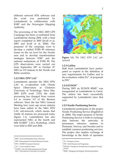
1.2.2 <strong>NKG</strong> EPN 8 LAC 9<br />
Lantmäteriet operates <strong>the</strong> <strong>NKG</strong> EPN<br />
LAC in co-operation with Onsala<br />
Space Observa<strong>to</strong>ry at Chalmers<br />
University <strong>of</strong> Technology. Since May<br />
2005 (GPS week 1321) <strong>the</strong> daily<br />
processing has changed from version<br />
4.2 <strong>to</strong> version 5.0 <strong>of</strong> <strong>the</strong> Bernese<br />
s<strong>of</strong>tware. Since <strong>the</strong> last <strong>NKG</strong> <strong>General</strong><br />
Meeting four years ago seven stations<br />
have been added <strong>to</strong> <strong>the</strong> <strong>NKG</strong> EPN<br />
LAC sub-network, which means that<br />
<strong>to</strong>tally 42 stations are processed <strong>to</strong>day<br />
(figure 1.1). Lantmäteriet has also<br />
represented <strong>NKG</strong> at <strong>the</strong> fourth and<br />
fifth EUREF 10<br />
LACs Workshop, which<br />
were held in 2003 and 2006.<br />
6<br />
KMS = Kort & Matrikelstyrelsen, Denmark<br />
7<br />
ITRF =International Terrestrial Reference Frame<br />
8<br />
EPN = EUREF Permanent Network<br />
9<br />
LAC = Local Analysis Centre<br />
10<br />
EUREF = <strong>the</strong> IAG Subcommission for Europe<br />
IAG = International Association <strong>of</strong> Geodesy<br />
Figure 1.1: The <strong>NKG</strong> EPN LAC subnetwork.<br />
1.2.3 Galileo<br />
Staff from Lantmäteriet have participated<br />
as experts in <strong>the</strong> definition <strong>of</strong><br />
user requirements for Galileo and in<br />
<strong>the</strong> evaluation within EU 11 <strong>of</strong> proposals<br />
in FP6 12 .<br />
1.2.4 EGNOS 13<br />
During 2003 an EGNOS RIMS 14<br />
was<br />
inaugurated at Lantmäteriet in Gävle.<br />
The station has been successfully<br />
supported by Lantmäteriet since that<br />
year.<br />
1.2.5 Nordic Positioning Service<br />
Lantmäteriet participates in <strong>the</strong> project<br />
Nordic Positioning Service (Engfeldt et<br />
al, 2006). The major purpose <strong>of</strong> Nordic<br />
Positioning Service is both <strong>to</strong> exchange<br />
data between <strong>the</strong> networks <strong>of</strong><br />
permanent reference stations in<br />
Denmark, Norway and Sweden and <strong>to</strong><br />
establish common positioning services.<br />
The project also implies exchange <strong>of</strong><br />
knowledge in <strong>the</strong> fields <strong>of</strong> operation<br />
11<br />
EU = European Union<br />
12<br />
FP6 = Sixth Framework Programme<br />
13<br />
EGNOS = European Geostationary Navigation Overlay<br />
System<br />
14<br />
RIMS = Ranging and Integrity Moni<strong>to</strong>ring Station