
Create successful ePaper yourself
Turn your PDF publications into a flip-book with our unique Google optimized e-Paper software.
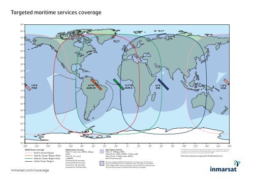
Targeted maritime services coverage<br />
90°<br />
80°<br />
70°<br />
60°<br />
50°<br />
40°<br />
30°<br />
20°<br />
10°<br />
0°<br />
10°<br />
178°E<br />
POR<br />
54°W<br />
AOR-W<br />
15.5°W<br />
AOR-E<br />
64°E<br />
IOR<br />
178°E<br />
POR<br />
20°<br />
30°<br />
40°<br />
50°<br />
60°<br />
70°<br />
80°<br />
90°<br />
180° 160° 140° 120° 100° 80° 60°<br />
20° 40° 60° 80° 100° 120° 140° 160° 180°<br />
Global beam coverage<br />
Pacific Ocean Region<br />
Atlantic Ocean Region-West<br />
Atlantic Ocean Region-East<br />
Indian Ocean Region<br />
inmarsat.com/coverage<br />
Global beam services<br />
Fleet 77 voice, fax, MPDS, 64kbps<br />
ISDN<br />
Fleet 55, 33, voice<br />
IsatM2M<br />
Inmarsat B (all services)<br />
Inmarsat M (all services)<br />
Inmarsat C (all services)<br />
Inmarsat D+ (all services)<br />
40° 20° 0°<br />
Spot beam services<br />
Fleet 77 128kbps ISDN<br />
Fleet 55 fax, ISDN, MPDS, 3.1Khz audio<br />
Fleet 33 fax, 9.6kbps data, MPDS<br />
Mini M (all services)<br />
Denotes targeted additional spot beam coverage once services have<br />
been transferred from the I-4 satellite to the I-3 satellite in the Atlantic<br />
Ocean Region-West. Actual coverage in this area will be confirmed once<br />
the services have been transferred and testing is complete.<br />
This map does not represent a guarantee of service. The availability of service at<br />
the edge of coverage areas fluctuates depending upon a variety of conditions.<br />
Targeted maritime services coverage September 2008.<br />
Please refer to separate coverage map for FleetBroadband service
Atlantic Ocean Region-West<br />
Indian Ocean Region<br />
Atlantic Ocean Region-East<br />
Pacific Ocean Region<br />
Global beam coverage<br />
Pacific Ocean Region<br />
Atlantic Ocean Region-West<br />
Atlantic Ocean Region-East<br />
Indian Ocean Region<br />
Global beam services<br />
Fleet 77 voice, fax, MPDS, 64kbps<br />
ISDN<br />
Fleet 55, 33, voice<br />
IsatM2M<br />
Inmarsat B (all services)<br />
Inmarsat M (all services)<br />
Inmarsat C (all services)<br />
Inmarsat D+ (all services)<br />
Spot beam services<br />
Fleet 77 128kbps ISDN<br />
Fleet 55 fax, ISDN, MPDS, 3.1Khz audio<br />
Fleet 33 fax, 9.6kbps data, MPDS<br />
Mini M (all services)<br />
Denotes targeted additional spot beam coverage once services have<br />
been transferred from the I-4 satellite to the I-3 satellite in the Atlantic<br />
Ocean Region-West. Actual coverage in this area will be confirmed once<br />
the services have been transferred and testing is complete.<br />
This map does not represent a guarantee of service. The availability of service at<br />
the edge of coverage areas fluctuates depending upon a variety of conditions.<br />
Targeted maritime services coverage September 2008.<br />
Please refer to separate coverage map for FleetBroadband service