Image Access Solutions - Exelis Visual Information Solutions
Image Access Solutions - Exelis Visual Information Solutions
Image Access Solutions - Exelis Visual Information Solutions

You also want an ePaper? Increase the reach of your titles
YUMPU automatically turns print PDFs into web optimized ePapers that Google loves.
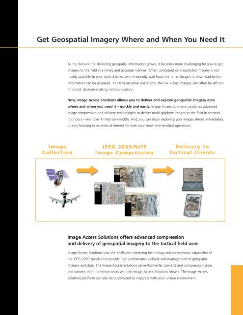
Get Geospatial <strong>Image</strong>ry Where and When You Need It<br />
As the demand for delivering geospatial information grows, it becomes more challenging for you to get<br />
imagery to the field in a timely and accurate manner. Often, processed or unexploited imagery is not<br />
readily available to your tactical users, who frequently wait hours for entire images to download before<br />
information can be accessed. For time-sensitive operations, the risk is that imagery can often be left out<br />
of critical, decision-making communications.<br />
Now, <strong>Image</strong> <strong>Access</strong> <strong>Solutions</strong> allows you to deliver and explore geospatial imagery data<br />
where and when you need it – quickly and easily. <strong>Image</strong> <strong>Access</strong> <strong>Solutions</strong> combines advanced<br />
image compression and delivery technologies to deliver multi-gigabyte images to the field in seconds,<br />
not hours – even over limited bandwidths. And, you can begin exploring your images almost immediately,<br />
quickly focusing in on areas of interest for even your most time-sensitive operations.<br />
<strong>Image</strong><br />
Collection<br />
JPEG 2000/NITF<br />
<strong>Image</strong> Compression<br />
Delivery to<br />
Tactical Clients<br />
<strong>Image</strong> <strong>Access</strong> <strong>Solutions</strong> offers advanced compression<br />
and delivery of geospatial imagery to the tactical field user.<br />
<strong>Image</strong> <strong>Access</strong> <strong>Solutions</strong> uses the intelligent streaming technology and compression capabilities of<br />
the JPEG 2000 standard to provide high performance delivery and management of geospatial<br />
imagery and data. The <strong>Image</strong> <strong>Access</strong> <strong>Solutions</strong> Server/Converter converts and compresses images<br />
and streams them to remote users with the <strong>Image</strong> <strong>Access</strong> <strong>Solutions</strong> Viewer. The <strong>Image</strong> <strong>Access</strong><br />
<strong>Solutions</strong> platform can also be customized to integrate with your unique environment.