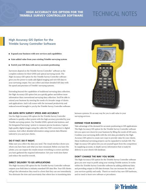
High‑Accuracy GIS option for the Trimble Survey ... - INLAND GPS
High‑Accuracy GIS option for the Trimble Survey ... - INLAND GPS
High‑Accuracy GIS option for the Trimble Survey ... - INLAND GPS

You also want an ePaper? Increase the reach of your titles
YUMPU automatically turns print PDFs into web optimized ePapers that Google loves.
HigH AccurAcy giS OptiOn fOr tHe<br />
trimble <strong>Survey</strong> cOntrOller SOftwAre<br />
technical notes<br />
High Accuracy <strong>GIS</strong> Option <strong>for</strong> <strong>the</strong><br />
<strong>Trimble</strong> <strong>Survey</strong> Controller Software<br />
• Expand your business with new services and capabilities<br />
• Gain added value from your existing <strong>Trimble</strong> surveying system<br />
• Enrich your <strong>GIS</strong> data with survey accurate positioning<br />
<strong>Survey</strong>ors depend on <strong>the</strong> <strong>Trimble</strong> <strong>Survey</strong> Controller software as <strong>the</strong><br />
complete solution <strong>for</strong> <strong>the</strong>ir GNSS and optical surveying needs. The<br />
High‐Accuracy <strong>GIS</strong> <strong>option</strong> <strong>for</strong> <strong>the</strong> <strong>Trimble</strong> <strong>Survey</strong> Controller software<br />
gives you <strong>the</strong> power to easily add digital imaging and rich <strong>GIS</strong> data to<br />
your surveying output. You can collect and share detailed <strong>GIS</strong> data with<br />
<strong>the</strong> speed and precision of <strong>Trimble</strong>® surveying systems.<br />
Extending beyond <strong>the</strong> capabilities of traditional surveying data collection,<br />
<strong>the</strong> High‐Accuracy <strong>GIS</strong> <strong>option</strong> lets you quickly ga<strong>the</strong>r and deliver more<br />
in<strong>for</strong>mation than conventional surveying data collection. You’ll be able to<br />
extend your business by meeting <strong>the</strong> needs of a broader range of clients<br />
and applications. And it all comes with <strong>the</strong> increased productivity and<br />
reduced rework brought to you by <strong>the</strong> <strong>Trimble</strong> <strong>Survey</strong> Controller software.<br />
<strong>GIS</strong> DATA WITH SURVEY SPEED AND ACCURACY<br />
Use <strong>the</strong> High‐Accuracy <strong>GIS</strong> <strong>option</strong> <strong>for</strong> <strong>the</strong> <strong>Trimble</strong> <strong>Survey</strong> Controller<br />
software to quickly collect points with <strong>the</strong> high accuracy provided by your<br />
<strong>Trimble</strong> surveying system. Use <strong>Trimble</strong> GNSS, optical total stations, and<br />
<strong>the</strong> Integrated <strong>Survey</strong>ing system to measure precise locations. Capture<br />
high‐quality digital images using <strong>the</strong> cable‐free WiFi connection to digital<br />
cameras. And collect detailed in<strong>for</strong>mation using custom data libraries<br />
tailored to you and your clients.<br />
DO IT FAST. DO IT RIGHT.<br />
Make sure you collect <strong>the</strong> data you need. The visual interface shows you<br />
where you have been and what you have measured. Be<strong>for</strong>e you leave <strong>the</strong><br />
jobsite, you can inspect <strong>the</strong> results ensure everything is correct and that<br />
you have ga<strong>the</strong>red <strong>the</strong> required in<strong>for</strong>mation. Get your work done faster<br />
and reduce <strong>the</strong> need <strong>for</strong> rework.<br />
DIRECT DELIVERY TO <strong>GIS</strong> APPLICATIONS<br />
The High‐Accuracy <strong>GIS</strong> <strong>option</strong> <strong>for</strong> <strong>the</strong> <strong>Trimble</strong> <strong>Survey</strong> Controller software<br />
outputs your field data to industry standard <strong>GIS</strong> data files. Your <strong>GIS</strong> clients<br />
will get <strong>the</strong> in<strong>for</strong>mation <strong>the</strong>y need in a <strong>for</strong>m that <strong>the</strong>y can use immediately.<br />
You eliminate <strong>the</strong> time and uncertainty that o<strong>the</strong>rs face in translating data<br />
between systems. It’s an easy way <strong>for</strong> you to add value to your<br />
surveying services.<br />
EXPAND YOUR BUSINESS<br />
Take advantage of <strong>the</strong> demand <strong>for</strong> accurate positioning in <strong>GIS</strong> applications.<br />
The High‐Accuracy <strong>GIS</strong> <strong>option</strong> <strong>for</strong> <strong>the</strong> <strong>Trimble</strong> <strong>Survey</strong> Controller software<br />
lets you open new doors <strong>for</strong> your business by filling <strong>the</strong> needs of <strong>GIS</strong> users.<br />
Combine your surveying skills with <strong>the</strong> rich data provided by <strong>the</strong> High‐<br />
Accuracy <strong>GIS</strong> <strong>option</strong> to create new ways to provide value <strong>for</strong> your clients.<br />
Many traditional surveying projects can be expanded to include <strong>GIS</strong>. The<br />
High‐Accuracy <strong>GIS</strong> <strong>option</strong> lets you set yourself apart from <strong>the</strong> competition<br />
by supplying accurate, in‐depth survey in<strong>for</strong>mation that is ready <strong>for</strong><br />
delivery to your client’s <strong>GIS</strong> database.<br />
DON’T CHANGE THE WAY YOU WORK<br />
The High‐Accuracy <strong>GIS</strong> <strong>option</strong> <strong>for</strong> <strong>the</strong> <strong>Trimble</strong> <strong>Survey</strong> Controller software<br />
gives you new ways to profit using your existing <strong>Trimble</strong> system. It works<br />
within <strong>the</strong> <strong>Trimble</strong> <strong>Survey</strong> Controller software by adding additional data<br />
and providing output to <strong>GIS</strong> data <strong>for</strong>mats. You can increase <strong>the</strong> value of<br />
your services quickly and easily. There’s no need to buy new <strong>GIS</strong> hardware,<br />
and no need to learn new software or procedures.
WORK IN A WIDE RANGE OF APPLICATIONS<br />
Accurate positions are not enough. You need more in<strong>for</strong>mation about <strong>the</strong><br />
conditions, surrounding location and more. <strong>Survey</strong>ors are called on to<br />
collect more detailed in<strong>for</strong>mation <strong>for</strong> existing and new applications.<br />
The High‐Accuracy <strong>GIS</strong> <strong>option</strong> gives you flexibility to efficiently handle<br />
<strong>the</strong> demand <strong>for</strong> increased detail.<br />
Utilities<br />
Use <strong>the</strong> High‐Accuracy <strong>GIS</strong> <strong>option</strong> to produce detailed, survey‐accurate<br />
in<strong>for</strong>mation on existing facilities and as‐builts of new installations. It’s<br />
ideal <strong>for</strong> ga<strong>the</strong>ring and sharing in<strong>for</strong>mation <strong>for</strong> compliance and facilities<br />
management.<br />
transportation<br />
Provide detailed surveys on existing conditions <strong>for</strong> maintenance,<br />
redevelopment and route planning. The High‐Accuracy <strong>GIS</strong> <strong>option</strong><br />
excels in collecting roadway inventories <strong>for</strong> signage and fixtures.<br />
land and Cadastral sUrveying<br />
Collect images of boundary markers, control points and reference markers,<br />
and <strong>the</strong>n add <strong>the</strong>m to <strong>the</strong> <strong>GIS</strong>. Supplement your position in<strong>for</strong>mation with<br />
visual data that is tied directly to <strong>the</strong> point in <strong>the</strong> field. Collect details on<br />
<strong>the</strong> location and status of buildings or o<strong>the</strong>r improvements.<br />
engineering and ConstrUCtion<br />
Add detail and photos to engineering surveys to aid in design and<br />
planning. Collect and store photos during topographic or as‐builts to<br />
document changes in site conditions. The High‐Accuracy <strong>GIS</strong> <strong>option</strong><br />
<strong>for</strong> <strong>Trimble</strong> <strong>Survey</strong> Controller software makes sure you have all <strong>the</strong> data.<br />
You’ll finish <strong>the</strong> survey quickly and reduce construction delays.<br />
natUral resoUrCes<br />
Bring <strong>the</strong> speed and accuracy of <strong>Trimble</strong> surveying systems to <strong>the</strong><br />
demanding needs of <strong>the</strong> natural resources market. Direct output to<br />
shapefiles lets you take rich data, precise positions, and images to<br />
your <strong>GIS</strong> or design systems.<br />
ADD VALUE TO YOUR SURVEYS WITH HIGH-QUALITY<br />
DIGITAL PHOTOS<br />
High‐quality digital images can also be useful in surveying applications<br />
by reducing errors and <strong>the</strong> need <strong>for</strong> return trips to <strong>the</strong> jobsite. With <strong>the</strong><br />
High‐Accuracy <strong>GIS</strong> <strong>option</strong> and a good resolution digital camera, you can<br />
get <strong>the</strong> needed detail from your photographs.<br />
Using <strong>the</strong> <strong>Trimble</strong> TrimPix technology, photos taken with certain Nikon<br />
COOLPIX digital cameras can be transferred to a <strong>Trimble</strong> TSC2® controller<br />
via <strong>the</strong> WiFi wireless datalink. When you take <strong>the</strong> photo, it is immediately<br />
stored on <strong>the</strong> controller. It’s fast, automatic, and error free.<br />
The High‐Accuracy <strong>GIS</strong> <strong>option</strong> <strong>for</strong> <strong>the</strong> <strong>Trimble</strong> <strong>Survey</strong> Controller software<br />
also supports <strong>the</strong> use of cameras not equipped with WiFi. After your<br />
photos are stored on your camera’s CF or SD memory card it’s fast and<br />
easy to transfer <strong>the</strong> images. You can insert <strong>the</strong> card into <strong>the</strong> slot in <strong>the</strong><br />
TRIMPIX TECHNOLOGY<br />
The <strong>Trimble</strong> TrimPix technology lets you add high quality digital<br />
photographs to your survey data quickly and easily. TrimPix uses <strong>the</strong><br />
built‐in WiFi on <strong>the</strong> <strong>Trimble</strong> TSC2 controller to connect to WiFi‐capable<br />
Nikon COOLPIX digital cameras. You’ll collect high resolution photos and<br />
store <strong>the</strong>m directly to your <strong>Trimble</strong> TSC2 controller.<br />
Setting up <strong>the</strong> TrimPix technology is easy. The TrimPix installation wizard<br />
guides you through <strong>the</strong> simple steps. You’ll use your office computer to<br />
install <strong>the</strong> software and set up <strong>the</strong> WiFi data link between <strong>the</strong> Nikon digital<br />
camera and <strong>the</strong> <strong>Trimble</strong> TSC2 controller. Do it once, and you’re done.<br />
In <strong>the</strong> field, you’ll select <strong>the</strong> Shoot and Transfer <strong>option</strong> on <strong>the</strong> camera.<br />
The TrimPix technology runs in <strong>the</strong> background on your <strong>Trimble</strong> TSC2<br />
controller to receive and store <strong>the</strong> images from <strong>the</strong> camera. It’s fast,<br />
seamless, and reliable.<br />
2
HigH AccurAcy giS OptiOn fOr tHe<br />
trimble <strong>Survey</strong> cOntrOller SOftwAre<br />
technical notes<br />
<strong>Trimble</strong> TSC2 controller and copy <strong>the</strong> images to <strong>the</strong> controller’s memory.<br />
On your <strong>Trimble</strong> CU controller, use <strong>the</strong> USB connection <strong>for</strong> fast, reliable<br />
transfer. You can collect multiple images during your project, <strong>the</strong>n transfer<br />
and attach to <strong>the</strong> survey points while still in <strong>the</strong> field. Be<strong>for</strong>e you leave <strong>the</strong><br />
jobsite you know that you have collected all <strong>the</strong> in<strong>for</strong>mation you need.<br />
COLLECT DIGITAL IMAGES WHEN YOU MEASURE<br />
POINTS IN THE FIELD<br />
When you use <strong>the</strong> High‐Accuracy <strong>GIS</strong> <strong>option</strong>, <strong>the</strong> <strong>Trimble</strong> <strong>Survey</strong><br />
Controller software adds image filenames to <strong>the</strong> list of attributes that<br />
are part of <strong>the</strong> feature code attached to each point. You can define<br />
multiple attributes <strong>for</strong> a point, so that several images can be taken and<br />
attached to <strong>the</strong> point. Define an attribute as ‘required,’ and <strong>the</strong> <strong>Trimble</strong><br />
<strong>Survey</strong> Controller software will remind you to take <strong>the</strong> photo and attach<br />
it to <strong>the</strong> point.<br />
SURVEY WORKFLOW, SURVEY ACCURACY, <strong>GIS</strong> DATA<br />
The High‐Accuracy <strong>GIS</strong> <strong>option</strong> <strong>for</strong> <strong>the</strong> <strong>Trimble</strong> <strong>Survey</strong> Controller<br />
software gives new power to your everyday surveying. Use <strong>the</strong> full<br />
functionality of <strong>the</strong> <strong>Trimble</strong> <strong>Survey</strong> Controller software in setting up<br />
your surveys, working with coordinate systems and collecting data.<br />
The <strong>Trimble</strong> <strong>Survey</strong> Controller software functions <strong>for</strong> stakeout, roading,<br />
and quality control are always available.<br />
The <strong>Trimble</strong> <strong>Survey</strong> Controller software allows you to use <strong>the</strong> <strong>Trimble</strong><br />
VRS networks as well. It eliminates <strong>the</strong> need <strong>for</strong> base stations to get<br />
you up and running with RTK precision as soon as you get to <strong>the</strong> field.<br />
When you need to collect more details, <strong>the</strong> High‐Accuracy <strong>GIS</strong> <strong>option</strong><br />
is ready. Add photos and detailed attribute in<strong>for</strong>mation to your points<br />
quickly and easily. It’s one stop, one workflow, one system. And one<br />
incredible solution.<br />
COMPLETE DATA TRANSFER IN THE FIELD OR OFFICE<br />
It’s fast and easy to share your field data and images with <strong>GIS</strong> systems.<br />
Use <strong>the</strong> High‐Accuracy <strong>GIS</strong> <strong>option</strong> to output your survey data directly to<br />
<strong>the</strong> shapefile <strong>for</strong>mat used by ESRI ArcMap and o<strong>the</strong>r <strong>GIS</strong> applications.<br />
<strong>Survey</strong>‐accurate coordinates, point attributes, and ties to photographs are<br />
output in a single operation. In addition to shapefiles, your conventional<br />
survey data is available <strong>for</strong> processing and analysis using <strong>the</strong> <strong>Trimble</strong><br />
Geomatics Office software. In <strong>the</strong> field, you can even create shapefiles and<br />
email <strong>the</strong>m to <strong>the</strong> office using <strong>the</strong> advanced communications <strong>option</strong>s of<br />
<strong>the</strong> <strong>Trimble</strong> <strong>Survey</strong> Controller software and your <strong>Trimble</strong> TSC2 controller.<br />
The High Accuracy <strong>GIS</strong> <strong>option</strong> makes data transfers fast and easy. When<br />
you use <strong>the</strong> <strong>Trimble</strong> Data Transfer utility, <strong>the</strong> system automatically<br />
copies <strong>the</strong> image files from <strong>the</strong> controller along with <strong>the</strong> shapefiles. Your<br />
in<strong>for</strong>mation is organized and ready <strong>for</strong> use in your <strong>GIS</strong> software.<br />
SUPPORTED SURVEYING EQUIPMENT<br />
The High Accuracy <strong>GIS</strong> <strong>option</strong> <strong>for</strong> <strong>the</strong> <strong>Trimble</strong> <strong>Survey</strong> Controller<br />
software supports <strong>the</strong> full complement of sensors in <strong>the</strong> <strong>Trimble</strong><br />
Integrated <strong>Survey</strong>ing system:<br />
• <strong>Trimble</strong> GNSS solutions including <strong>the</strong> <strong>Trimble</strong> R8 GNSS, <strong>Trimble</strong> R6,<br />
5800, <strong>Trimble</strong> R7, and 5700 receivers.<br />
• <strong>Trimble</strong> optical families including <strong>the</strong> <strong>Trimble</strong> S8, <strong>Trimble</strong> S6, and<br />
<strong>Trimble</strong> 5600 total stations.<br />
• <strong>Trimble</strong> VX Spatial Station <strong>for</strong> Spatial Imaging<br />
The High‐Accuracy <strong>GIS</strong> <strong>option</strong> runs on <strong>the</strong> <strong>Trimble</strong> TSC2 or <strong>Trimble</strong> CU<br />
controllers running <strong>the</strong> <strong>Trimble</strong> <strong>Survey</strong> Controller Version 12.22 software<br />
or later. WiFi data transfer of digital photos using <strong>the</strong> <strong>Trimble</strong> TrimPix<br />
technology is available on <strong>the</strong> <strong>Trimble</strong> TSC2 controller only.<br />
3
HigH AccurAcy giS OptiOn fOr tHe<br />
trimble <strong>Survey</strong> cOntrOller SOftwAre<br />
technical notes<br />
© 2008, <strong>Trimble</strong> Navigation Limited. All rights reserved. <strong>Trimble</strong>, <strong>the</strong> Globe & Triangle logo, and TSC2 are trademarks of <strong>Trimble</strong> Navigation Limited, registered in <strong>the</strong> United States and in o<strong>the</strong>r countries. Integrated <strong>Survey</strong>ing, <strong>Trimble</strong> Geomatics<br />
Office, <strong>Trimble</strong> <strong>Survey</strong> Controller, TrimPix, VRS, and VX are trademarks of <strong>Trimble</strong> Navigation Limited. All o<strong>the</strong>r trademarks are <strong>the</strong> property of <strong>the</strong>ir respective owners. PN 022543-455 (09/08)<br />
NORTH AMERICA<br />
<strong>Trimble</strong> Engineering and<br />
Construction Group<br />
5475 Kellenburger Road<br />
Dayton, Ohio 45424-1099<br />
USA<br />
800-538-7800 (Toll Free)<br />
+1-937-245-5154 Phone<br />
+1-937-233-9441 Fax<br />
EUROPE<br />
<strong>Trimble</strong> GmbH<br />
Am Prime Parc 11<br />
65479 Raunheim<br />
GERMANY<br />
+49-6142-2100-0 Phone<br />
+49-6142-2100-550 Fax<br />
ASIA-PACIFIC<br />
<strong>Trimble</strong> Navigation<br />
Singapore PTE Limited<br />
80 Marine Parade Road<br />
#22-06, Parkway Parade<br />
Singapore 449269<br />
SINGAPORE<br />
+65-6348-2212 Phone<br />
+65-6348-2232 Fax<br />
TRIMBLE auThoRIzEd dIsTRIBuTIon paRTnER<br />
www.trimble.com