Trimble Survey Controller Software - Accupoint
Trimble Survey Controller Software - Accupoint
Trimble Survey Controller Software - Accupoint

You also want an ePaper? Increase the reach of your titles
YUMPU automatically turns print PDFs into web optimized ePapers that Google loves.
<strong>Trimble</strong> survey conTroller field sofTware<br />
technical notes<br />
For more than a decade, <strong>Trimble</strong> <strong>Survey</strong> <strong>Controller</strong> field software has provided land surveyors with a<br />
complete GNSS and optical data-collection solution that reduces rework and increases productivity. Advanced<br />
yet easy to use, <strong>Trimble</strong> <strong>Survey</strong> <strong>Controller</strong> software helps you complete every job faster and more easily.<br />
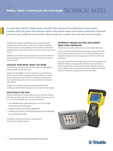
<strong>Trimble</strong> <strong>Survey</strong> <strong>Controller</strong> field software runs on advanced <strong>Trimble</strong>®<br />
controllers such as the <strong>Trimble</strong> CU and TSC2® controllers. The software<br />
runs from a real-time color map display on the latest Microsoft Windows®<br />
operating systems, and provides an easy-to-use touch screen for rapid access<br />
to data.<br />
<strong>Trimble</strong> <strong>Survey</strong> <strong>Controller</strong> software integrates survey data from GNSS and<br />
optical surveying instruments, as well as 3D scanning data from selected<br />
<strong>Trimble</strong> systems 1 .<br />
VISUALIZE YOUR WORK, WHILE YOU WORK<br />
<strong>Trimble</strong> <strong>Survey</strong> <strong>Controller</strong> provides full color maps and unique graphical<br />
support, making every job much easier.<br />
Graphic color map displays are easy to read and use. An active map of a<br />
job site on-screen makes measuring points fast and efficient. To increase<br />
productivity further, feature codes can be assigned to measured points.<br />
This capability makes points easier to locate and identify in the field and<br />
office software.<br />
EXPERIENCE UNEQUALLED FIELD INTELLIGENCE<br />
FROM YOUR CONTROLLER<br />
<strong>Trimble</strong> <strong>Survey</strong> <strong>Controller</strong> software does more than simply collect data.<br />
As the power behind <strong>Trimble</strong> Integrated <strong>Survey</strong>ing solutions, the <strong>Trimble</strong><br />
<strong>Survey</strong> <strong>Controller</strong> software allows you to collect GNSS and optical data in<br />
one Job file. It makes survey data management in the field and office easy<br />
and efficient.<br />
Advanced communication technologies allow you to work very productively.<br />
Bluetooth® wireless technology enables cable-free connection between a<br />
<strong>Trimble</strong> controller and a surveying sensor for fast set-up and convenience<br />
when working. Internet connection between field and office is also possible:<br />
When your work is done, simply email your files to the office.<br />
<strong>Trimble</strong> <strong>Survey</strong> <strong>Controller</strong> software also supports <strong>Trimble</strong> VISION<br />
technology in <strong>Trimble</strong> Spatial Imaging sensors, with real-time video display.<br />
MULTI-TASK IN THE FIELD<br />
Because <strong>Trimble</strong> <strong>Survey</strong> <strong>Controller</strong> software runs on a Microsoft Windows<br />
operating system, the menus and controls are familiar and easy-to-use, and<br />
you can work in the field the same way you do in the office:<br />
• Keep multiple software applications open at once ( for example,<br />
COGO, Stakeout, Point Manager).<br />
• Quickly and easily switch between applications.<br />
• Customize your options so that the applications you most frequently<br />
use are instantly accessible.<br />
The ability to multi-task is an industry-unique feature of<br />
<strong>Trimble</strong> <strong>Survey</strong> <strong>Controller</strong> software.<br />
1 trimble survey controller software supports the trimble ® VX spatial station.
TRIMBLE INTEGRATED SURVEYING: SEAMLESS CONVENTIONAL AND GNSS SURVEYING<br />
The <strong>Trimble</strong> Integrated <strong>Survey</strong>ing solution remains the<br />
industry standard for survey data management and transfer.<br />
The <strong>Trimble</strong> <strong>Survey</strong> <strong>Controller</strong> software running on the<br />
controller of your choice—the <strong>Trimble</strong> CU or TSC2—allows<br />
you to use the same job and settings for total stations and<br />
GNSS receivers. If you need to switch from a GNSS system to<br />
a total station or vice versa, simply connect to a new sensor<br />
and keep working in the same job; avoid wasting time with<br />
data transfer between different field software. The same<br />
background maps and coordinate systems will apply.<br />
<strong>Trimble</strong> I.S. Rover<br />
Taking Integrated <strong>Survey</strong>ing further, the <strong>Trimble</strong> <strong>Survey</strong><br />
<strong>Controller</strong> software supports the <strong>Trimble</strong> I.S. Rover, so you<br />
can stay connected to a GNSS receiver and a robotic total<br />
station at the same time.<br />
The <strong>Trimble</strong> I.S. Rover enables you to:<br />
• Use the most appropriate tool—GNSS or<br />
conventional—according to conditions on the job site:<br />
Maximize time in the field measuring.<br />
• Increase productivity when establishing control:<br />
Establish control by measuring points with either<br />
technology, or both.<br />
• Use one job for managing and recording all your data:<br />
Remove the need to transfer data.<br />
• Improve data integrity: Measure points with both<br />
technologies for truly independent verification and<br />
confirmation of survey accuracy.<br />
• Expedite target searches with the GPS Search<br />
function in the <strong>Trimble</strong> <strong>Survey</strong> <strong>Controller</strong> software:<br />
With GPS Search the <strong>Trimble</strong> I.S. Rover will typically<br />
turn directly to the prism within three seconds.<br />
TRANSFER DATA BETWEEN FIELD<br />
AND OFFICE<br />
Data transfer to and from the <strong>Trimble</strong> <strong>Survey</strong><br />
<strong>Controller</strong> software is fast, easy, and flexible.<br />
Advanced communication options such as a<br />
mobile Internet connection using a Bluetooth<br />
connection to a mobile phone, or a WiFi<br />
connection to the Internet, enables you to transfer<br />
data wirelessly to your office.<br />
You can seamlessly transfer data between the<br />
<strong>Trimble</strong> <strong>Survey</strong> <strong>Controller</strong> software in the field and<br />
<strong>Trimble</strong> office software such as <strong>Trimble</strong> Business<br />
Center, <strong>Trimble</strong> Geomatics Office, RealWorks®<br />
<strong>Survey</strong>, <strong>Trimble</strong> Total Control, and Terramodel®.<br />
These packages support many native data formats<br />
of popular survey, design, and GIS packages.<br />
In addition, data from third-party survey, design<br />
or GIS software can be easily transferred into the<br />
<strong>Trimble</strong> <strong>Survey</strong> <strong>Controller</strong> software. For example,<br />
the embedded <strong>Trimble</strong> Link module allows direct<br />
data transfer between <strong>Trimble</strong> <strong>Survey</strong> <strong>Controller</strong><br />
and Autodesk Land Desktop or CAiCE software.<br />
<strong>Trimble</strong> <strong>Survey</strong> Extension provides the same easy<br />
transfer mechanism for ESRI’s ArcGIS <strong>Survey</strong><br />
Analyst software.<br />
Data can be imported/exported in the following<br />
file formats:<br />
• DC files<br />
• JobXML files<br />
• CSV files<br />
• DXF, SHP: Active map, features of these files<br />
can be directly accessed in the field.<br />
• Roading files: <strong>Trimble</strong> Roads (rxl), Genio,<br />
LandXML<br />
• Custom ASCII import and export to easily<br />
transfer data from/to third-party solutions<br />
Email Data from the Field<br />
For easy transfer from the field to the office<br />
<strong>Trimble</strong> <strong>Survey</strong> <strong>Controller</strong> software allows you to<br />
email files directly from your controller. You can<br />
attach zipped files and a brief description and<br />
send to any e-mail address. Not only can you share<br />
work with your office without leaving the job; this<br />
function also provides a simple way to back up<br />
your work.<br />
2
<strong>Trimble</strong> survey conTroller field sofTware technical notes<br />
CONTROL SURVEYS<br />
Station Setup and Station Elevation<br />
<strong>Trimble</strong> <strong>Survey</strong> <strong>Controller</strong> software provides several ways to establish a<br />
station:<br />
• Simple station setup<br />
• Using multiple backsights<br />
• Resection<br />
• Refline<br />
When using the resection or multiple backsights functionality, advanced<br />
statistical reports show the station setup plus residuals.<br />
Site Calibration<br />
For GNSS surveys, you can apply a site calibration before staking out<br />
points or computing offset or intersection points. The solution adjusts the<br />
projected (grid) coordinates to fit the local control. And you are in complete<br />
control—you can either key in site calibration details or let the system<br />
compute the site calibration for you.<br />
Duplicate Points and Averaging<br />
<strong>Trimble</strong> <strong>Survey</strong> <strong>Controller</strong> software also provides several ways to check your<br />
data. You can perform duplicate point tolerance checking. And if you have<br />
multiple GNSS or conventional measurements to one point, you can choose<br />
to average your measurements.<br />
Multiple rounds of observations can be collected automatically when using<br />
the Autolock® function in a <strong>Trimble</strong> total station. Simply identify the points<br />
when measuring the first face observations.<br />
The station elevation function allows you to determine the height<br />
of your instrument by observing to one or more marks with<br />
known elevation.<br />
Refline is the process of establishing the position of an occupied point<br />
relative to a baseline. To perform a refline station establishment, take<br />
measurements to two known or unknown baseline definition points. Once<br />
this occupation point is defined, all subsequent points are stored in terms of<br />
the baseline using station and offset. This method is often used when setting<br />
out buildings parallel to other objects or boundaries.<br />
TRIMBLE FUNCTIONS FORM<br />
The <strong>Trimble</strong> Functions Form allows you to quickly and easily control instrument functions and change instrument settings. For<br />
example, depending on the type of instrument you can:<br />
Turn on the Tracklight<br />
Put the instrument into<br />
DR (Direct Reflex)<br />
reflectorless mode<br />
Use the Joystick when at<br />
the instrument or working<br />
in Robotic mode, to turn<br />
the instrument both<br />
horizontally and vertically<br />
and control the speed at<br />
which it turns<br />
Change Face<br />
Turn to a selected point<br />
Search controls—look for<br />
a target<br />
Lock onto a remote target<br />
using Autolock<br />
3
TOPOGRAPHIC SURVEYS<br />
<strong>Trimble</strong> <strong>Survey</strong> <strong>Controller</strong> software provides a complete set of topographic<br />
survey tools.<br />
Quick Height/Width Measurement<br />
The Remote Object function allows you to easily determine the height or<br />
width of remote objects that cannot be measured with a prism—it is ideal<br />
for power lines and radio masts, or for objects where safety is also an issue.<br />
Feature Coding<br />
The powerful feature coding capabilities of Measure Codes reduce or<br />
eliminate postprocessing, data-editing time, and errors in the office. You can<br />
continue to use familiar code names by customizing feature-code libraries.<br />
For high-accuracy GIS surveys, the data dictionaries you can create to suit<br />
your job/application simplify even demanding and complex field attribute<br />
collection.<br />
Continuous <strong>Survey</strong>ing<br />
<strong>Survey</strong> without stopping. You can plot a continuous line, even a topo map,<br />
simply by walking or driving over the terrain and recording points at time<br />
and distance increments you define. Use stop-and-go to measure points<br />
exactly where you want them without pressing a single key. In RTK<br />
mode you can create up to two offsets—horizontal and vertical—with<br />
feature codes.<br />
<strong>Trimble</strong> <strong>Survey</strong> <strong>Controller</strong> software also enables continuous measuring in<br />
marine applications using selected echo sounders.<br />
COGO<br />
<strong>Trimble</strong> <strong>Survey</strong> <strong>Controller</strong> Coordinate Geometry (COGO) functionality<br />
allows you to calculate distances, azimuths and point positions by various<br />
methods. You can also rotate, translate, and scale a single point or a<br />
selection of points.<br />
COGO features for managing and editing local transformations are<br />
invaluable when points to be staked out use a different coordinate system<br />
from the current job.<br />
3D SCANNING WITH THE TRIMBLE VX SPATIAL STATION<br />
When controlling the <strong>Trimble</strong> VX Spatial Station, the <strong>Trimble</strong> <strong>Survey</strong> <strong>Controller</strong> software offers many 3D<br />
scanning possibilities. Quickly define scan areas with predefined selection methods and then scan up to<br />
15 points per second. The <strong>Trimble</strong> <strong>Survey</strong> <strong>Controller</strong> software gives easy access to scan parameters, where<br />
you can define the number of points to be scanned based on angle and distance intervals. You can also<br />
choose a scanning mode: High Speed, Long Range (TRK), and Long Range (STD). High speed supports<br />
the fastest scanning capabilities of the <strong>Trimble</strong> VX Spatial Station, while the long-range options scan at a<br />
speed similar to other servo driven total stations used with the Surface Scan feature in the <strong>Trimble</strong> <strong>Survey</strong><br />
<strong>Controller</strong> software.<br />
Alternatively, simply state the time allowed for the scan and the <strong>Trimble</strong> <strong>Survey</strong> <strong>Controller</strong> software will<br />
automatically calculate the number of points to be taken. You can store images with your scan area for QA<br />
and metadata, and/or export the scan data to RealWorks <strong>Survey</strong> office software for postprocessing.<br />
4
<strong>Trimble</strong> survey conTroller field sofTware technical notes<br />
HIGH ACCURACY GIS OPTION<br />
<strong>Trimble</strong> <strong>Survey</strong> <strong>Controller</strong> software offers a high-accuracy GIS option for<br />
surveyors and surveying businesses wanting to expand their portfolios to<br />
include this type of work. The option delivers powerful, flexible capabilities<br />
via the familiar surveying environment. For more information, please refer to<br />
the <strong>Trimble</strong> <strong>Survey</strong> <strong>Controller</strong> – High Accuracy GIS Technical Notes.<br />
STAKEOUT<br />
The <strong>Trimble</strong> <strong>Survey</strong> <strong>Controller</strong> software offers unsurpassed stakeout<br />
capabilities. The graphical stakeout screens and the active map guide you to<br />
each point quickly and easily.<br />
<strong>Trimble</strong> <strong>Survey</strong> <strong>Controller</strong> software offers several ways to specify points to be<br />
measured:<br />
• Simply enter the point name for a quick and easy workflow.<br />
• Build a stakeout list from comma delimited (.CSV) files. You don’t<br />
need to import the design points into the current job database—only<br />
measured points that you store are added to the job file, optimizing<br />
the job file’s size and manageability.<br />
• If staking out points with incrementing names, simply do so directly<br />
from the graphics window. (See below.)<br />
Graphical stakeout<br />
You can stake out directly from the active map: Just tap and hold on the<br />
point and select Stakeout from the drop-down list that appears. Other<br />
options include Review, Compute Inverse, Key in Line, Compute Area, Delete,<br />
and more. The powerful stakeout screen makes it fast and easy to stake out<br />
points, roads, lines, arcs, slopes, and surfaces. Use either the text on the right<br />
of the screen or the graphical display on the left to navigate to the point.<br />
Staking out with a robotic total station has also never been easier. When the<br />
instrument has locked on to the target, the continuous stakeout tracking in<br />
the graphical screen updates your target position in real-time. When you are<br />
close to the point, the large arrows guide you to the stakeout point.<br />
Audible voice prompts<br />
In conventional stakeout, pre-recorded sound messages in your language of<br />
choice tell you to “Go Left”, “Go Right”, “Go In”, or “Go Out” to guide you to<br />
the point easily. “Stake point” indicates when you have reached the point.<br />
Stakeout from Active Maps<br />
With the use of the active map capabilities in the <strong>Trimble</strong> <strong>Survey</strong> <strong>Controller</strong><br />
software you can stake out points, lines, and arcs from a .dxf or .shp (shape)<br />
file directly in the field. Just copy the file to your <strong>Trimble</strong> data directory and<br />
select the features of interest graphically from the map screen.<br />
TRIMBLE SURVEY CONTROLLER SOFTWARE FOR GNSS INFRASTRUCTURE<br />
On GNSS surveys there's no need for a base station when working in a <strong>Trimble</strong> VRS network. You can be up and running as soon as you get to the field. The<br />
<strong>Trimble</strong> <strong>Survey</strong> <strong>Controller</strong> software fully supports <strong>Trimble</strong>'s GNSS infrastructure solutions. The <strong>Trimble</strong> <strong>Survey</strong> <strong>Controller</strong> software is also WAAS and EGNOS<br />
capable, so that all your infrastructure options are covered.<br />
RTK-on-Demand (Patented)<br />
When using the <strong>Trimble</strong> <strong>Survey</strong> <strong>Controller</strong> software as part of a GNSS infrastructure solution, you<br />
can use <strong>Trimble</strong> RTK-on-Demand to ensure efficient and cost-effective Internet connection. RTKon-Demand<br />
is a unique feature of <strong>Trimble</strong> GPSNet infrastructure software. It works by allowing<br />
a user to pause the data stream from the Internet as necessary, for instance, data is only streamed<br />
when a point is being measured or if initialization is lost. The <strong>Trimble</strong> <strong>Survey</strong> <strong>Controller</strong> software<br />
automatically prompts the GPSNet software to stream and pause data.<br />
5
ROAD STAKEOUT<br />
The <strong>Trimble</strong> <strong>Survey</strong> <strong>Controller</strong> software accepts uploaded road definitions<br />
from many third-party sources. You can also key in a complete road<br />
definition including horizontal and vertical alignments, templates and<br />
superelevation, and widening records. And if you work with LandXML or<br />
GENIO road files, the software reads these files directly.<br />
Real-Time Quality Control<br />
You can place your measurement equipment anywhere on site and instantly<br />
see a grid position, station, offset, and cut/fill report.<br />
This excellent tool lets you check stakes in record time, and make spot<br />
checks on points, grades, and earthworks progress.<br />
The unique cross-section view provides a comprehensive graphical view<br />
of the road at the selected station. Your position and the target are clearly<br />
indicated and you have all the information necessary to mark up the stakes.<br />
Construction Offsets<br />
During stakeout you can stake out an offset from your point. You can apply a<br />
horizontal offset either horizontally or by the slope of the previous template<br />
element. You can also apply a vertical offset. Construction offsets are shown<br />
in the cross-section view.<br />
Slope Staking<br />
Now you can find and stake the points where the design surface and the<br />
existing surface intersect much more easily and accurately. This is done on<br />
site in real time using unique cross-section graphics.<br />
Real-Time Redesign<br />
Often a job design does not take into consideration situations arising in<br />
the actual field. For example, design elevations may need altering to better<br />
suit existing structures, or side slopes may require adjusting due to ground<br />
conditions. The <strong>Trimble</strong> <strong>Survey</strong> <strong>Controller</strong> software provides full in-field<br />
capabilities of all aspects of the design.<br />
THE TRIMBLE SURVEY CONTROLLER SOFTWARE<br />
ENGINEERING OPTION<br />
The <strong>Trimble</strong> <strong>Survey</strong> <strong>Controller</strong> Engineering Option is a set of features<br />
targeted towards specific workflows not typical for traditional surveying<br />
work. This option is ideal for use with the <strong>Trimble</strong> S8 Total Station.<br />
Tunneling<br />
For tunneling applications the Engineering option gives you an easy-tofollow<br />
workflow. The graphical user interface helps you visualize the design<br />
and as-built data, and it guides you through tasks such as marking areas of<br />
under- and overcut with the laser pointer of the <strong>Trimble</strong> S8 Total Station.<br />
The software automatically adjusts so a position is measured on station, and<br />
it allows you to key in and set out positions relative to a tunnel, for example,<br />
for bolt holes.<br />
In this Tunnel-Scan view, both the design and the as-built are visible, and<br />
over- and undercut are graphically highlighted in red and green. Set out<br />
positions defined relative to the tunnel appear as thin radial lines in the view.<br />
Cross Slope<br />
Graphical selection makes cross slope application as easy as tapping<br />
the template element that defines the cross slope. The <strong>Trimble</strong> <strong>Survey</strong><br />
<strong>Controller</strong> software will navigate you to the position and provide you with<br />
the resultant cross slope delta value.<br />
6
<strong>Trimble</strong> survey conTroller field sofTware technical notes<br />
Monitoring Applications – Extension to Automated Rounds<br />
An extension to the familiar rounds program in the <strong>Trimble</strong> <strong>Survey</strong><br />
<strong>Controller</strong> software expedites data collection for monitoring applications.<br />
On a first site visit you can create and save target files. Then on subsequent<br />
visits you can quickly measure to the same targets—manual measurements<br />
are not necessary.<br />
You can read more about the Engineering option, its features, and<br />
applications, in the <strong>Trimble</strong> <strong>Survey</strong> <strong>Controller</strong> – Engineering Option<br />
Technical Notes.<br />
IN-FIELD CHECKS AND QUALITY ASSURANCE<br />
Job Review and Point Manager<br />
The Review Current Job feature gives you a complete and detailed record<br />
of everything that happened in the field—it is a real electronic field book.<br />
Alternatively use the Point Manager feature to manage your data.<br />
Easily review:<br />
• Coordinates and observations<br />
• The best point and all duplicate points<br />
• Target and antenna heights<br />
• Codes and notes<br />
QC Graph<br />
The QC Graph screen displays quality indicators available from data in a job.<br />
Use this tool to quickly identify an erroneous measurement or an incorrect<br />
target height.<br />
View a graph of:<br />
• Horizontal and vertical precision<br />
• Satellites<br />
• PDOP, RMS, and standard errors for HA, VA, and Slope distance<br />
• Elevation<br />
• Target height<br />
Custom Reports<br />
The <strong>Trimble</strong> <strong>Survey</strong> <strong>Controller</strong> software exports data in many different<br />
formats. The flexibility to create different files is invaluable for checking data<br />
in the field, and for producing reports to e-mail to the office or your client.<br />
Use the default styles provided with the <strong>Trimble</strong> <strong>Survey</strong> <strong>Controller</strong> software<br />
or create your own XML style sheet to set up a custom format.<br />
Quickly and easily edit:<br />
• Target and antenna heights (single or multiple)<br />
• Codes and notes<br />
STREAMING VIDEO WITH THE TRIMBLE VX SPATIAL STATION<br />
<strong>Trimble</strong> VISION technology in the <strong>Trimble</strong> VX Spatial Station offers<br />
digital image streaming and capture. It enables you to view digital images<br />
of a job site through the <strong>Trimble</strong> <strong>Survey</strong> <strong>Controller</strong> software.<br />
Measure Faster<br />
VISION technology saves time when measuring: Instead of looking<br />
through the telescope, simply use the controller touch screen to select<br />
the point you want to measure. You can easily identify your target point<br />
in the video stream.<br />
3D Data Overlay<br />
Superimpose measured points and linework onto the digital image of<br />
the job site. Reduce your rework by checking which measurements have<br />
been completed, and never leave the field with unfinished work.<br />
Take Pictures for Quality Control and Simple<br />
Data Handover<br />
<strong>Trimble</strong> <strong>Survey</strong> <strong>Controller</strong> software allows you to capture images from<br />
the digital stream. This digital camera capability is easily accessed<br />
through software softkeys. The still images can be stored for<br />
quality control.<br />
7
CONCLUSION<br />
<strong>Trimble</strong> <strong>Survey</strong> <strong>Controller</strong> software is a key component of the <strong>Trimble</strong> Connected Site model. It provides the<br />
seamless data flow that supports Integrated <strong>Survey</strong>ing, and brings all the parts of your job together.<br />
<strong>Trimble</strong> <strong>Survey</strong> <strong>Controller</strong> software is a field-proven solution with advanced<br />
features and benefits that will revolutionize the way you work.<br />
It provides:<br />
• Bluetooth wireless technology for cable-free operation.<br />
• Internet and email capabilities in the field for keeping in touch with<br />
the office wherever you are.<br />
• Map-centric touch screen display and sound prompts for maximum<br />
convenience and ease of use in all aspects of your work.<br />
• Integrated <strong>Survey</strong>ing with <strong>Trimble</strong> GNSS and conventional sensors,<br />
and most major optical and robotic surveying instruments and<br />
laser rangefinders.<br />
• Seamless data flow between a variety of instruments to office<br />
software systems, using a choice of transfer methods from serial cable<br />
to Internet to infrared.<br />
• Powerful features in your preferred language to reduce rework and<br />
increase productivity.<br />
SUPPORTED SURVEYING SENSORS<br />
<strong>Trimble</strong> <strong>Survey</strong> <strong>Controller</strong> software communicates with almost every<br />
field instrument you use for the original field-proven Integrated<br />
<strong>Survey</strong>ing system:<br />
• <strong>Trimble</strong> GNSS solutions including the <strong>Trimble</strong> R8 GNSS,<br />
<strong>Trimble</strong> R6, 5800, <strong>Trimble</strong> R7 and 5700<br />
• <strong>Trimble</strong> optical families including the <strong>Trimble</strong> S6, 5600, 5500,<br />
3600, 3300, and 600M<br />
• <strong>Trimble</strong> VX Spatial Station for spatial imaging<br />
• Other <strong>Trimble</strong> controllers<br />
• Laser rangefinders—several leading models<br />
• Third-party optical total stations<br />
<strong>Trimble</strong> <strong>Survey</strong> <strong>Controller</strong> software is the total surveying software solution.<br />
© 2001–2008. <strong>Trimble</strong> Navigation Limited. All rights reserved. <strong>Trimble</strong>, the Globe & Triangle logo, Autolock, Terramodel, and TSC2 are trademarks of <strong>Trimble</strong> Navigation Limited, registered in the United States and in other countries.<br />
GPSNet, Integrated <strong>Survey</strong>ing, <strong>Trimble</strong> Geomatics Office, <strong>Trimble</strong> <strong>Survey</strong> <strong>Controller</strong>, <strong>Trimble</strong> Total Control, <strong>Trimble</strong> VISION, <strong>Trimble</strong> VX, and VRS are trademarks of <strong>Trimble</strong> Navigation Limited. The Bluetooth word mark and logos are<br />
owned by the Bluetooth SIG, Inc. and any use of such marks by <strong>Trimble</strong> Navigation Limited is under license. RealWorks is a registered trademark of Mensi SA. Microsoft and Windows are either registered trademarks or trademarks of<br />
Microsoft Corporation in the United States and/or other countries. All other trademarks are the property of their respective owners. PN 022504-023G (09/08)<br />
NORTH AMERICA<br />
<strong>Trimble</strong> Engineering<br />
& Construction Group<br />
5475 Kellenburger Road<br />
Dayton, Ohio 45424-1099 • USA<br />
800-538-7800 (Toll Free)<br />
+1-937-245-5154 Phone<br />
+1-937-233-9441 Fax<br />
EUROPE<br />
<strong>Trimble</strong> GmbH<br />
Am Prime Parc 11<br />
65479 Raunheim • GERMANY<br />
+49-6142-2100-0 Phone<br />
+49-6142-2100-550 Fax<br />
ASIA-PACIFIC<br />
<strong>Trimble</strong> Navigation<br />
Singapore Pty Limited<br />
80 Marine Parade Road<br />
#22-06, Parkway Parade<br />
Singapore 449269 • SINGAPORE<br />
+65-6348-2212 Phone<br />
+65-6348-2232 Fax<br />
<strong>Trimble</strong> auThorized disTribuTion ParTner<br />
www.trimble.com