Trimble Survey Controller Software - Accupoint
Trimble Survey Controller Software - Accupoint
Trimble Survey Controller Software - Accupoint

Create successful ePaper yourself
Turn your PDF publications into a flip-book with our unique Google optimized e-Paper software.
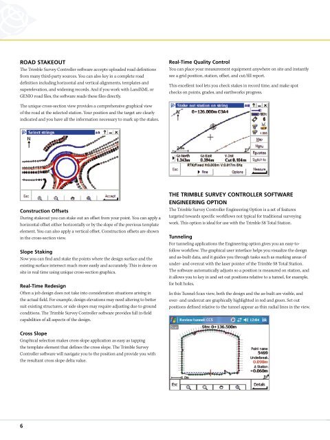
ROAD STAKEOUT<br />
The <strong>Trimble</strong> <strong>Survey</strong> <strong>Controller</strong> software accepts uploaded road definitions<br />
from many third-party sources. You can also key in a complete road<br />
definition including horizontal and vertical alignments, templates and<br />
superelevation, and widening records. And if you work with LandXML or<br />
GENIO road files, the software reads these files directly.<br />
Real-Time Quality Control<br />
You can place your measurement equipment anywhere on site and instantly<br />
see a grid position, station, offset, and cut/fill report.<br />
This excellent tool lets you check stakes in record time, and make spot<br />
checks on points, grades, and earthworks progress.<br />
The unique cross-section view provides a comprehensive graphical view<br />
of the road at the selected station. Your position and the target are clearly<br />
indicated and you have all the information necessary to mark up the stakes.<br />
Construction Offsets<br />
During stakeout you can stake out an offset from your point. You can apply a<br />
horizontal offset either horizontally or by the slope of the previous template<br />
element. You can also apply a vertical offset. Construction offsets are shown<br />
in the cross-section view.<br />
Slope Staking<br />
Now you can find and stake the points where the design surface and the<br />
existing surface intersect much more easily and accurately. This is done on<br />
site in real time using unique cross-section graphics.<br />
Real-Time Redesign<br />
Often a job design does not take into consideration situations arising in<br />
the actual field. For example, design elevations may need altering to better<br />
suit existing structures, or side slopes may require adjusting due to ground<br />
conditions. The <strong>Trimble</strong> <strong>Survey</strong> <strong>Controller</strong> software provides full in-field<br />
capabilities of all aspects of the design.<br />
THE TRIMBLE SURVEY CONTROLLER SOFTWARE<br />
ENGINEERING OPTION<br />
The <strong>Trimble</strong> <strong>Survey</strong> <strong>Controller</strong> Engineering Option is a set of features<br />
targeted towards specific workflows not typical for traditional surveying<br />
work. This option is ideal for use with the <strong>Trimble</strong> S8 Total Station.<br />
Tunneling<br />
For tunneling applications the Engineering option gives you an easy-tofollow<br />
workflow. The graphical user interface helps you visualize the design<br />
and as-built data, and it guides you through tasks such as marking areas of<br />
under- and overcut with the laser pointer of the <strong>Trimble</strong> S8 Total Station.<br />
The software automatically adjusts so a position is measured on station, and<br />
it allows you to key in and set out positions relative to a tunnel, for example,<br />
for bolt holes.<br />
In this Tunnel-Scan view, both the design and the as-built are visible, and<br />
over- and undercut are graphically highlighted in red and green. Set out<br />
positions defined relative to the tunnel appear as thin radial lines in the view.<br />
Cross Slope<br />
Graphical selection makes cross slope application as easy as tapping<br />
the template element that defines the cross slope. The <strong>Trimble</strong> <strong>Survey</strong><br />
<strong>Controller</strong> software will navigate you to the position and provide you with<br />
the resultant cross slope delta value.<br />
6