Trimble Survey Controller Software - Accupoint
Trimble Survey Controller Software - Accupoint
Trimble Survey Controller Software - Accupoint

Create successful ePaper yourself
Turn your PDF publications into a flip-book with our unique Google optimized e-Paper software.
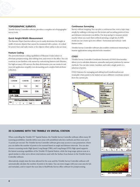
TOPOGRAPHIC SURVEYS<br />
<strong>Trimble</strong> <strong>Survey</strong> <strong>Controller</strong> software provides a complete set of topographic<br />
survey tools.<br />
Quick Height/Width Measurement<br />
The Remote Object function allows you to easily determine the height or<br />
width of remote objects that cannot be measured with a prism—it is ideal<br />
for power lines and radio masts, or for objects where safety is also an issue.<br />
Feature Coding<br />
The powerful feature coding capabilities of Measure Codes reduce or<br />
eliminate postprocessing, data-editing time, and errors in the office. You can<br />
continue to use familiar code names by customizing feature-code libraries.<br />
For high-accuracy GIS surveys, the data dictionaries you can create to suit<br />
your job/application simplify even demanding and complex field attribute<br />
collection.<br />
Continuous <strong>Survey</strong>ing<br />
<strong>Survey</strong> without stopping. You can plot a continuous line, even a topo map,<br />
simply by walking or driving over the terrain and recording points at time<br />
and distance increments you define. Use stop-and-go to measure points<br />
exactly where you want them without pressing a single key. In RTK<br />
mode you can create up to two offsets—horizontal and vertical—with<br />
feature codes.<br />
<strong>Trimble</strong> <strong>Survey</strong> <strong>Controller</strong> software also enables continuous measuring in<br />
marine applications using selected echo sounders.<br />
COGO<br />
<strong>Trimble</strong> <strong>Survey</strong> <strong>Controller</strong> Coordinate Geometry (COGO) functionality<br />
allows you to calculate distances, azimuths and point positions by various<br />
methods. You can also rotate, translate, and scale a single point or a<br />
selection of points.<br />
COGO features for managing and editing local transformations are<br />
invaluable when points to be staked out use a different coordinate system<br />
from the current job.<br />
3D SCANNING WITH THE TRIMBLE VX SPATIAL STATION<br />
When controlling the <strong>Trimble</strong> VX Spatial Station, the <strong>Trimble</strong> <strong>Survey</strong> <strong>Controller</strong> software offers many 3D<br />
scanning possibilities. Quickly define scan areas with predefined selection methods and then scan up to<br />
15 points per second. The <strong>Trimble</strong> <strong>Survey</strong> <strong>Controller</strong> software gives easy access to scan parameters, where<br />
you can define the number of points to be scanned based on angle and distance intervals. You can also<br />
choose a scanning mode: High Speed, Long Range (TRK), and Long Range (STD). High speed supports<br />
the fastest scanning capabilities of the <strong>Trimble</strong> VX Spatial Station, while the long-range options scan at a<br />
speed similar to other servo driven total stations used with the Surface Scan feature in the <strong>Trimble</strong> <strong>Survey</strong><br />
<strong>Controller</strong> software.<br />
Alternatively, simply state the time allowed for the scan and the <strong>Trimble</strong> <strong>Survey</strong> <strong>Controller</strong> software will<br />
automatically calculate the number of points to be taken. You can store images with your scan area for QA<br />
and metadata, and/or export the scan data to RealWorks <strong>Survey</strong> office software for postprocessing.<br />
4