Trimble Survey Controller Software - Accupoint
Trimble Survey Controller Software - Accupoint
Trimble Survey Controller Software - Accupoint

You also want an ePaper? Increase the reach of your titles
YUMPU automatically turns print PDFs into web optimized ePapers that Google loves.
<strong>Trimble</strong> survey conTroller field sofTware technical notes<br />
CONTROL SURVEYS<br />
Station Setup and Station Elevation<br />
<strong>Trimble</strong> <strong>Survey</strong> <strong>Controller</strong> software provides several ways to establish a<br />
station:<br />
• Simple station setup<br />
• Using multiple backsights<br />
• Resection<br />
• Refline<br />
When using the resection or multiple backsights functionality, advanced<br />
statistical reports show the station setup plus residuals.<br />
Site Calibration<br />
For GNSS surveys, you can apply a site calibration before staking out<br />
points or computing offset or intersection points. The solution adjusts the<br />
projected (grid) coordinates to fit the local control. And you are in complete<br />
control—you can either key in site calibration details or let the system<br />
compute the site calibration for you.<br />
Duplicate Points and Averaging<br />
<strong>Trimble</strong> <strong>Survey</strong> <strong>Controller</strong> software also provides several ways to check your<br />
data. You can perform duplicate point tolerance checking. And if you have<br />
multiple GNSS or conventional measurements to one point, you can choose<br />
to average your measurements.<br />
Multiple rounds of observations can be collected automatically when using<br />
the Autolock® function in a <strong>Trimble</strong> total station. Simply identify the points<br />
when measuring the first face observations.<br />
The station elevation function allows you to determine the height<br />
of your instrument by observing to one or more marks with<br />
known elevation.<br />
Refline is the process of establishing the position of an occupied point<br />
relative to a baseline. To perform a refline station establishment, take<br />
measurements to two known or unknown baseline definition points. Once<br />
this occupation point is defined, all subsequent points are stored in terms of<br />
the baseline using station and offset. This method is often used when setting<br />
out buildings parallel to other objects or boundaries.<br />
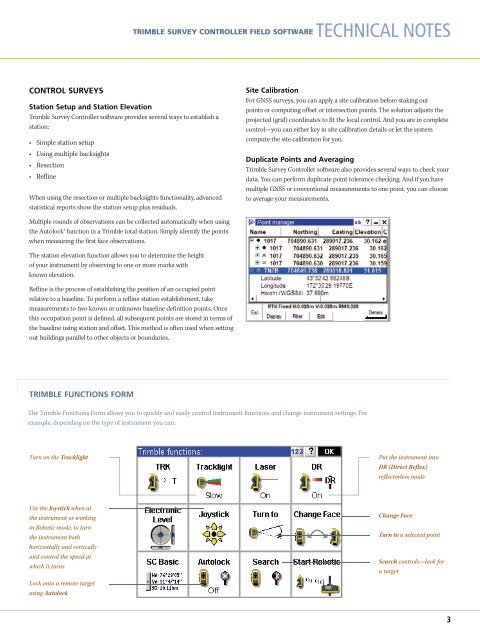
TRIMBLE FUNCTIONS FORM<br />
The <strong>Trimble</strong> Functions Form allows you to quickly and easily control instrument functions and change instrument settings. For<br />
example, depending on the type of instrument you can:<br />
Turn on the Tracklight<br />
Put the instrument into<br />
DR (Direct Reflex)<br />
reflectorless mode<br />
Use the Joystick when at<br />
the instrument or working<br />
in Robotic mode, to turn<br />
the instrument both<br />
horizontally and vertically<br />
and control the speed at<br />
which it turns<br />
Change Face<br />
Turn to a selected point<br />
Search controls—look for<br />
a target<br />
Lock onto a remote target<br />
using Autolock<br />
3