Trimble Survey Controller Software - Accupoint
Trimble Survey Controller Software - Accupoint
Trimble Survey Controller Software - Accupoint

Create successful ePaper yourself
Turn your PDF publications into a flip-book with our unique Google optimized e-Paper software.
<strong>Trimble</strong> survey conTroller field sofTware technical notes<br />
HIGH ACCURACY GIS OPTION<br />
<strong>Trimble</strong> <strong>Survey</strong> <strong>Controller</strong> software offers a high-accuracy GIS option for<br />
surveyors and surveying businesses wanting to expand their portfolios to<br />
include this type of work. The option delivers powerful, flexible capabilities<br />
via the familiar surveying environment. For more information, please refer to<br />
the <strong>Trimble</strong> <strong>Survey</strong> <strong>Controller</strong> – High Accuracy GIS Technical Notes.<br />
STAKEOUT<br />
The <strong>Trimble</strong> <strong>Survey</strong> <strong>Controller</strong> software offers unsurpassed stakeout<br />
capabilities. The graphical stakeout screens and the active map guide you to<br />
each point quickly and easily.<br />
<strong>Trimble</strong> <strong>Survey</strong> <strong>Controller</strong> software offers several ways to specify points to be<br />
measured:<br />
• Simply enter the point name for a quick and easy workflow.<br />
• Build a stakeout list from comma delimited (.CSV) files. You don’t<br />
need to import the design points into the current job database—only<br />
measured points that you store are added to the job file, optimizing<br />
the job file’s size and manageability.<br />
• If staking out points with incrementing names, simply do so directly<br />
from the graphics window. (See below.)<br />
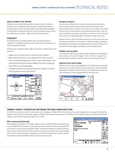
Graphical stakeout<br />
You can stake out directly from the active map: Just tap and hold on the<br />
point and select Stakeout from the drop-down list that appears. Other<br />
options include Review, Compute Inverse, Key in Line, Compute Area, Delete,<br />
and more. The powerful stakeout screen makes it fast and easy to stake out<br />
points, roads, lines, arcs, slopes, and surfaces. Use either the text on the right<br />
of the screen or the graphical display on the left to navigate to the point.<br />
Staking out with a robotic total station has also never been easier. When the<br />
instrument has locked on to the target, the continuous stakeout tracking in<br />
the graphical screen updates your target position in real-time. When you are<br />
close to the point, the large arrows guide you to the stakeout point.<br />
Audible voice prompts<br />
In conventional stakeout, pre-recorded sound messages in your language of<br />
choice tell you to “Go Left”, “Go Right”, “Go In”, or “Go Out” to guide you to<br />
the point easily. “Stake point” indicates when you have reached the point.<br />
Stakeout from Active Maps<br />
With the use of the active map capabilities in the <strong>Trimble</strong> <strong>Survey</strong> <strong>Controller</strong><br />
software you can stake out points, lines, and arcs from a .dxf or .shp (shape)<br />
file directly in the field. Just copy the file to your <strong>Trimble</strong> data directory and<br />
select the features of interest graphically from the map screen.<br />
TRIMBLE SURVEY CONTROLLER SOFTWARE FOR GNSS INFRASTRUCTURE<br />
On GNSS surveys there's no need for a base station when working in a <strong>Trimble</strong> VRS network. You can be up and running as soon as you get to the field. The<br />
<strong>Trimble</strong> <strong>Survey</strong> <strong>Controller</strong> software fully supports <strong>Trimble</strong>'s GNSS infrastructure solutions. The <strong>Trimble</strong> <strong>Survey</strong> <strong>Controller</strong> software is also WAAS and EGNOS<br />
capable, so that all your infrastructure options are covered.<br />
RTK-on-Demand (Patented)<br />
When using the <strong>Trimble</strong> <strong>Survey</strong> <strong>Controller</strong> software as part of a GNSS infrastructure solution, you<br />
can use <strong>Trimble</strong> RTK-on-Demand to ensure efficient and cost-effective Internet connection. RTKon-Demand<br />
is a unique feature of <strong>Trimble</strong> GPSNet infrastructure software. It works by allowing<br />
a user to pause the data stream from the Internet as necessary, for instance, data is only streamed<br />
when a point is being measured or if initialization is lost. The <strong>Trimble</strong> <strong>Survey</strong> <strong>Controller</strong> software<br />
automatically prompts the GPSNet software to stream and pause data.<br />
5