High‑Accuracy GIS option for the Trimble Survey ... - INLAND GPS
High‑Accuracy GIS option for the Trimble Survey ... - INLAND GPS
High‑Accuracy GIS option for the Trimble Survey ... - INLAND GPS

Create successful ePaper yourself
Turn your PDF publications into a flip-book with our unique Google optimized e-Paper software.
WORK IN A WIDE RANGE OF APPLICATIONS<br />
Accurate positions are not enough. You need more in<strong>for</strong>mation about <strong>the</strong><br />
conditions, surrounding location and more. <strong>Survey</strong>ors are called on to<br />
collect more detailed in<strong>for</strong>mation <strong>for</strong> existing and new applications.<br />
The High‐Accuracy <strong>GIS</strong> <strong>option</strong> gives you flexibility to efficiently handle<br />
<strong>the</strong> demand <strong>for</strong> increased detail.<br />
Utilities<br />
Use <strong>the</strong> High‐Accuracy <strong>GIS</strong> <strong>option</strong> to produce detailed, survey‐accurate<br />
in<strong>for</strong>mation on existing facilities and as‐builts of new installations. It’s<br />
ideal <strong>for</strong> ga<strong>the</strong>ring and sharing in<strong>for</strong>mation <strong>for</strong> compliance and facilities<br />
management.<br />
transportation<br />
Provide detailed surveys on existing conditions <strong>for</strong> maintenance,<br />
redevelopment and route planning. The High‐Accuracy <strong>GIS</strong> <strong>option</strong><br />
excels in collecting roadway inventories <strong>for</strong> signage and fixtures.<br />
land and Cadastral sUrveying<br />
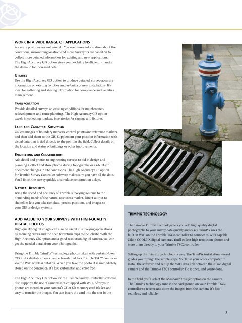
Collect images of boundary markers, control points and reference markers,<br />
and <strong>the</strong>n add <strong>the</strong>m to <strong>the</strong> <strong>GIS</strong>. Supplement your position in<strong>for</strong>mation with<br />
visual data that is tied directly to <strong>the</strong> point in <strong>the</strong> field. Collect details on<br />
<strong>the</strong> location and status of buildings or o<strong>the</strong>r improvements.<br />
engineering and ConstrUCtion<br />
Add detail and photos to engineering surveys to aid in design and<br />
planning. Collect and store photos during topographic or as‐builts to<br />
document changes in site conditions. The High‐Accuracy <strong>GIS</strong> <strong>option</strong><br />
<strong>for</strong> <strong>Trimble</strong> <strong>Survey</strong> Controller software makes sure you have all <strong>the</strong> data.<br />
You’ll finish <strong>the</strong> survey quickly and reduce construction delays.<br />
natUral resoUrCes<br />
Bring <strong>the</strong> speed and accuracy of <strong>Trimble</strong> surveying systems to <strong>the</strong><br />
demanding needs of <strong>the</strong> natural resources market. Direct output to<br />
shapefiles lets you take rich data, precise positions, and images to<br />
your <strong>GIS</strong> or design systems.<br />
ADD VALUE TO YOUR SURVEYS WITH HIGH-QUALITY<br />
DIGITAL PHOTOS<br />
High‐quality digital images can also be useful in surveying applications<br />
by reducing errors and <strong>the</strong> need <strong>for</strong> return trips to <strong>the</strong> jobsite. With <strong>the</strong><br />
High‐Accuracy <strong>GIS</strong> <strong>option</strong> and a good resolution digital camera, you can<br />
get <strong>the</strong> needed detail from your photographs.<br />
Using <strong>the</strong> <strong>Trimble</strong> TrimPix technology, photos taken with certain Nikon<br />
COOLPIX digital cameras can be transferred to a <strong>Trimble</strong> TSC2® controller<br />
via <strong>the</strong> WiFi wireless datalink. When you take <strong>the</strong> photo, it is immediately<br />
stored on <strong>the</strong> controller. It’s fast, automatic, and error free.<br />
The High‐Accuracy <strong>GIS</strong> <strong>option</strong> <strong>for</strong> <strong>the</strong> <strong>Trimble</strong> <strong>Survey</strong> Controller software<br />
also supports <strong>the</strong> use of cameras not equipped with WiFi. After your<br />
photos are stored on your camera’s CF or SD memory card it’s fast and<br />
easy to transfer <strong>the</strong> images. You can insert <strong>the</strong> card into <strong>the</strong> slot in <strong>the</strong><br />
TRIMPIX TECHNOLOGY<br />
The <strong>Trimble</strong> TrimPix technology lets you add high quality digital<br />
photographs to your survey data quickly and easily. TrimPix uses <strong>the</strong><br />
built‐in WiFi on <strong>the</strong> <strong>Trimble</strong> TSC2 controller to connect to WiFi‐capable<br />
Nikon COOLPIX digital cameras. You’ll collect high resolution photos and<br />
store <strong>the</strong>m directly to your <strong>Trimble</strong> TSC2 controller.<br />
Setting up <strong>the</strong> TrimPix technology is easy. The TrimPix installation wizard<br />
guides you through <strong>the</strong> simple steps. You’ll use your office computer to<br />
install <strong>the</strong> software and set up <strong>the</strong> WiFi data link between <strong>the</strong> Nikon digital<br />
camera and <strong>the</strong> <strong>Trimble</strong> TSC2 controller. Do it once, and you’re done.<br />
In <strong>the</strong> field, you’ll select <strong>the</strong> Shoot and Transfer <strong>option</strong> on <strong>the</strong> camera.<br />
The TrimPix technology runs in <strong>the</strong> background on your <strong>Trimble</strong> TSC2<br />
controller to receive and store <strong>the</strong> images from <strong>the</strong> camera. It’s fast,<br />
seamless, and reliable.<br />
2