High‑Accuracy GIS option for the Trimble Survey ... - INLAND GPS
High‑Accuracy GIS option for the Trimble Survey ... - INLAND GPS
High‑Accuracy GIS option for the Trimble Survey ... - INLAND GPS

Create successful ePaper yourself
Turn your PDF publications into a flip-book with our unique Google optimized e-Paper software.
HigH AccurAcy giS OptiOn fOr tHe<br />
trimble <strong>Survey</strong> cOntrOller SOftwAre<br />
technical notes<br />
High Accuracy <strong>GIS</strong> Option <strong>for</strong> <strong>the</strong><br />
<strong>Trimble</strong> <strong>Survey</strong> Controller Software<br />
• Expand your business with new services and capabilities<br />
• Gain added value from your existing <strong>Trimble</strong> surveying system<br />
• Enrich your <strong>GIS</strong> data with survey accurate positioning<br />
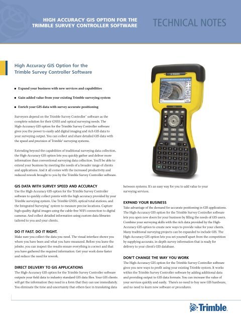
<strong>Survey</strong>ors depend on <strong>the</strong> <strong>Trimble</strong> <strong>Survey</strong> Controller software as <strong>the</strong><br />
complete solution <strong>for</strong> <strong>the</strong>ir GNSS and optical surveying needs. The<br />
High‐Accuracy <strong>GIS</strong> <strong>option</strong> <strong>for</strong> <strong>the</strong> <strong>Trimble</strong> <strong>Survey</strong> Controller software<br />
gives you <strong>the</strong> power to easily add digital imaging and rich <strong>GIS</strong> data to<br />
your surveying output. You can collect and share detailed <strong>GIS</strong> data with<br />
<strong>the</strong> speed and precision of <strong>Trimble</strong>® surveying systems.<br />
Extending beyond <strong>the</strong> capabilities of traditional surveying data collection,<br />
<strong>the</strong> High‐Accuracy <strong>GIS</strong> <strong>option</strong> lets you quickly ga<strong>the</strong>r and deliver more<br />
in<strong>for</strong>mation than conventional surveying data collection. You’ll be able to<br />
extend your business by meeting <strong>the</strong> needs of a broader range of clients<br />
and applications. And it all comes with <strong>the</strong> increased productivity and<br />
reduced rework brought to you by <strong>the</strong> <strong>Trimble</strong> <strong>Survey</strong> Controller software.<br />
<strong>GIS</strong> DATA WITH SURVEY SPEED AND ACCURACY<br />
Use <strong>the</strong> High‐Accuracy <strong>GIS</strong> <strong>option</strong> <strong>for</strong> <strong>the</strong> <strong>Trimble</strong> <strong>Survey</strong> Controller<br />
software to quickly collect points with <strong>the</strong> high accuracy provided by your<br />
<strong>Trimble</strong> surveying system. Use <strong>Trimble</strong> GNSS, optical total stations, and<br />
<strong>the</strong> Integrated <strong>Survey</strong>ing system to measure precise locations. Capture<br />
high‐quality digital images using <strong>the</strong> cable‐free WiFi connection to digital<br />
cameras. And collect detailed in<strong>for</strong>mation using custom data libraries<br />
tailored to you and your clients.<br />
DO IT FAST. DO IT RIGHT.<br />
Make sure you collect <strong>the</strong> data you need. The visual interface shows you<br />
where you have been and what you have measured. Be<strong>for</strong>e you leave <strong>the</strong><br />
jobsite, you can inspect <strong>the</strong> results ensure everything is correct and that<br />
you have ga<strong>the</strong>red <strong>the</strong> required in<strong>for</strong>mation. Get your work done faster<br />
and reduce <strong>the</strong> need <strong>for</strong> rework.<br />
DIRECT DELIVERY TO <strong>GIS</strong> APPLICATIONS<br />
The High‐Accuracy <strong>GIS</strong> <strong>option</strong> <strong>for</strong> <strong>the</strong> <strong>Trimble</strong> <strong>Survey</strong> Controller software<br />
outputs your field data to industry standard <strong>GIS</strong> data files. Your <strong>GIS</strong> clients<br />
will get <strong>the</strong> in<strong>for</strong>mation <strong>the</strong>y need in a <strong>for</strong>m that <strong>the</strong>y can use immediately.<br />
You eliminate <strong>the</strong> time and uncertainty that o<strong>the</strong>rs face in translating data<br />
between systems. It’s an easy way <strong>for</strong> you to add value to your<br />
surveying services.<br />
EXPAND YOUR BUSINESS<br />
Take advantage of <strong>the</strong> demand <strong>for</strong> accurate positioning in <strong>GIS</strong> applications.<br />
The High‐Accuracy <strong>GIS</strong> <strong>option</strong> <strong>for</strong> <strong>the</strong> <strong>Trimble</strong> <strong>Survey</strong> Controller software<br />
lets you open new doors <strong>for</strong> your business by filling <strong>the</strong> needs of <strong>GIS</strong> users.<br />
Combine your surveying skills with <strong>the</strong> rich data provided by <strong>the</strong> High‐<br />
Accuracy <strong>GIS</strong> <strong>option</strong> to create new ways to provide value <strong>for</strong> your clients.<br />
Many traditional surveying projects can be expanded to include <strong>GIS</strong>. The<br />
High‐Accuracy <strong>GIS</strong> <strong>option</strong> lets you set yourself apart from <strong>the</strong> competition<br />
by supplying accurate, in‐depth survey in<strong>for</strong>mation that is ready <strong>for</strong><br />
delivery to your client’s <strong>GIS</strong> database.<br />
DON’T CHANGE THE WAY YOU WORK<br />
The High‐Accuracy <strong>GIS</strong> <strong>option</strong> <strong>for</strong> <strong>the</strong> <strong>Trimble</strong> <strong>Survey</strong> Controller software<br />
gives you new ways to profit using your existing <strong>Trimble</strong> system. It works<br />
within <strong>the</strong> <strong>Trimble</strong> <strong>Survey</strong> Controller software by adding additional data<br />
and providing output to <strong>GIS</strong> data <strong>for</strong>mats. You can increase <strong>the</strong> value of<br />
your services quickly and easily. There’s no need to buy new <strong>GIS</strong> hardware,<br />
and no need to learn new software or procedures.
WORK IN A WIDE RANGE OF APPLICATIONS<br />
Accurate positions are not enough. You need more in<strong>for</strong>mation about <strong>the</strong><br />
conditions, surrounding location and more. <strong>Survey</strong>ors are called on to<br />
collect more detailed in<strong>for</strong>mation <strong>for</strong> existing and new applications.<br />
The High‐Accuracy <strong>GIS</strong> <strong>option</strong> gives you flexibility to efficiently handle<br />
<strong>the</strong> demand <strong>for</strong> increased detail.<br />
Utilities<br />
Use <strong>the</strong> High‐Accuracy <strong>GIS</strong> <strong>option</strong> to produce detailed, survey‐accurate<br />
in<strong>for</strong>mation on existing facilities and as‐builts of new installations. It’s<br />
ideal <strong>for</strong> ga<strong>the</strong>ring and sharing in<strong>for</strong>mation <strong>for</strong> compliance and facilities<br />
management.<br />
transportation<br />
Provide detailed surveys on existing conditions <strong>for</strong> maintenance,<br />
redevelopment and route planning. The High‐Accuracy <strong>GIS</strong> <strong>option</strong><br />
excels in collecting roadway inventories <strong>for</strong> signage and fixtures.<br />
land and Cadastral sUrveying<br />
Collect images of boundary markers, control points and reference markers,<br />
and <strong>the</strong>n add <strong>the</strong>m to <strong>the</strong> <strong>GIS</strong>. Supplement your position in<strong>for</strong>mation with<br />
visual data that is tied directly to <strong>the</strong> point in <strong>the</strong> field. Collect details on<br />
<strong>the</strong> location and status of buildings or o<strong>the</strong>r improvements.<br />
engineering and ConstrUCtion<br />
Add detail and photos to engineering surveys to aid in design and<br />
planning. Collect and store photos during topographic or as‐builts to<br />
document changes in site conditions. The High‐Accuracy <strong>GIS</strong> <strong>option</strong><br />
<strong>for</strong> <strong>Trimble</strong> <strong>Survey</strong> Controller software makes sure you have all <strong>the</strong> data.<br />
You’ll finish <strong>the</strong> survey quickly and reduce construction delays.<br />
natUral resoUrCes<br />
Bring <strong>the</strong> speed and accuracy of <strong>Trimble</strong> surveying systems to <strong>the</strong><br />
demanding needs of <strong>the</strong> natural resources market. Direct output to<br />
shapefiles lets you take rich data, precise positions, and images to<br />
your <strong>GIS</strong> or design systems.<br />
ADD VALUE TO YOUR SURVEYS WITH HIGH-QUALITY<br />
DIGITAL PHOTOS<br />
High‐quality digital images can also be useful in surveying applications<br />
by reducing errors and <strong>the</strong> need <strong>for</strong> return trips to <strong>the</strong> jobsite. With <strong>the</strong><br />
High‐Accuracy <strong>GIS</strong> <strong>option</strong> and a good resolution digital camera, you can<br />
get <strong>the</strong> needed detail from your photographs.<br />
Using <strong>the</strong> <strong>Trimble</strong> TrimPix technology, photos taken with certain Nikon<br />
COOLPIX digital cameras can be transferred to a <strong>Trimble</strong> TSC2® controller<br />
via <strong>the</strong> WiFi wireless datalink. When you take <strong>the</strong> photo, it is immediately<br />
stored on <strong>the</strong> controller. It’s fast, automatic, and error free.<br />
The High‐Accuracy <strong>GIS</strong> <strong>option</strong> <strong>for</strong> <strong>the</strong> <strong>Trimble</strong> <strong>Survey</strong> Controller software<br />
also supports <strong>the</strong> use of cameras not equipped with WiFi. After your<br />
photos are stored on your camera’s CF or SD memory card it’s fast and<br />
easy to transfer <strong>the</strong> images. You can insert <strong>the</strong> card into <strong>the</strong> slot in <strong>the</strong><br />
TRIMPIX TECHNOLOGY<br />
The <strong>Trimble</strong> TrimPix technology lets you add high quality digital<br />
photographs to your survey data quickly and easily. TrimPix uses <strong>the</strong><br />
built‐in WiFi on <strong>the</strong> <strong>Trimble</strong> TSC2 controller to connect to WiFi‐capable<br />
Nikon COOLPIX digital cameras. You’ll collect high resolution photos and<br />
store <strong>the</strong>m directly to your <strong>Trimble</strong> TSC2 controller.<br />
Setting up <strong>the</strong> TrimPix technology is easy. The TrimPix installation wizard<br />
guides you through <strong>the</strong> simple steps. You’ll use your office computer to<br />
install <strong>the</strong> software and set up <strong>the</strong> WiFi data link between <strong>the</strong> Nikon digital<br />
camera and <strong>the</strong> <strong>Trimble</strong> TSC2 controller. Do it once, and you’re done.<br />
In <strong>the</strong> field, you’ll select <strong>the</strong> Shoot and Transfer <strong>option</strong> on <strong>the</strong> camera.<br />
The TrimPix technology runs in <strong>the</strong> background on your <strong>Trimble</strong> TSC2<br />
controller to receive and store <strong>the</strong> images from <strong>the</strong> camera. It’s fast,<br />
seamless, and reliable.<br />
2
HigH AccurAcy giS OptiOn fOr tHe<br />
trimble <strong>Survey</strong> cOntrOller SOftwAre<br />
technical notes<br />
<strong>Trimble</strong> TSC2 controller and copy <strong>the</strong> images to <strong>the</strong> controller’s memory.<br />
On your <strong>Trimble</strong> CU controller, use <strong>the</strong> USB connection <strong>for</strong> fast, reliable<br />
transfer. You can collect multiple images during your project, <strong>the</strong>n transfer<br />
and attach to <strong>the</strong> survey points while still in <strong>the</strong> field. Be<strong>for</strong>e you leave <strong>the</strong><br />
jobsite you know that you have collected all <strong>the</strong> in<strong>for</strong>mation you need.<br />
COLLECT DIGITAL IMAGES WHEN YOU MEASURE<br />
POINTS IN THE FIELD<br />
When you use <strong>the</strong> High‐Accuracy <strong>GIS</strong> <strong>option</strong>, <strong>the</strong> <strong>Trimble</strong> <strong>Survey</strong><br />
Controller software adds image filenames to <strong>the</strong> list of attributes that<br />
are part of <strong>the</strong> feature code attached to each point. You can define<br />
multiple attributes <strong>for</strong> a point, so that several images can be taken and<br />
attached to <strong>the</strong> point. Define an attribute as ‘required,’ and <strong>the</strong> <strong>Trimble</strong><br />
<strong>Survey</strong> Controller software will remind you to take <strong>the</strong> photo and attach<br />
it to <strong>the</strong> point.<br />
SURVEY WORKFLOW, SURVEY ACCURACY, <strong>GIS</strong> DATA<br />
The High‐Accuracy <strong>GIS</strong> <strong>option</strong> <strong>for</strong> <strong>the</strong> <strong>Trimble</strong> <strong>Survey</strong> Controller<br />
software gives new power to your everyday surveying. Use <strong>the</strong> full<br />
functionality of <strong>the</strong> <strong>Trimble</strong> <strong>Survey</strong> Controller software in setting up<br />
your surveys, working with coordinate systems and collecting data.<br />
The <strong>Trimble</strong> <strong>Survey</strong> Controller software functions <strong>for</strong> stakeout, roading,<br />
and quality control are always available.<br />
The <strong>Trimble</strong> <strong>Survey</strong> Controller software allows you to use <strong>the</strong> <strong>Trimble</strong><br />
VRS networks as well. It eliminates <strong>the</strong> need <strong>for</strong> base stations to get<br />
you up and running with RTK precision as soon as you get to <strong>the</strong> field.<br />
When you need to collect more details, <strong>the</strong> High‐Accuracy <strong>GIS</strong> <strong>option</strong><br />
is ready. Add photos and detailed attribute in<strong>for</strong>mation to your points<br />
quickly and easily. It’s one stop, one workflow, one system. And one<br />
incredible solution.<br />
COMPLETE DATA TRANSFER IN THE FIELD OR OFFICE<br />
It’s fast and easy to share your field data and images with <strong>GIS</strong> systems.<br />
Use <strong>the</strong> High‐Accuracy <strong>GIS</strong> <strong>option</strong> to output your survey data directly to<br />
<strong>the</strong> shapefile <strong>for</strong>mat used by ESRI ArcMap and o<strong>the</strong>r <strong>GIS</strong> applications.<br />
<strong>Survey</strong>‐accurate coordinates, point attributes, and ties to photographs are<br />
output in a single operation. In addition to shapefiles, your conventional<br />
survey data is available <strong>for</strong> processing and analysis using <strong>the</strong> <strong>Trimble</strong><br />
Geomatics Office software. In <strong>the</strong> field, you can even create shapefiles and<br />
email <strong>the</strong>m to <strong>the</strong> office using <strong>the</strong> advanced communications <strong>option</strong>s of<br />
<strong>the</strong> <strong>Trimble</strong> <strong>Survey</strong> Controller software and your <strong>Trimble</strong> TSC2 controller.<br />
The High Accuracy <strong>GIS</strong> <strong>option</strong> makes data transfers fast and easy. When<br />
you use <strong>the</strong> <strong>Trimble</strong> Data Transfer utility, <strong>the</strong> system automatically<br />
copies <strong>the</strong> image files from <strong>the</strong> controller along with <strong>the</strong> shapefiles. Your<br />
in<strong>for</strong>mation is organized and ready <strong>for</strong> use in your <strong>GIS</strong> software.<br />
SUPPORTED SURVEYING EQUIPMENT<br />
The High Accuracy <strong>GIS</strong> <strong>option</strong> <strong>for</strong> <strong>the</strong> <strong>Trimble</strong> <strong>Survey</strong> Controller<br />
software supports <strong>the</strong> full complement of sensors in <strong>the</strong> <strong>Trimble</strong><br />
Integrated <strong>Survey</strong>ing system:<br />
• <strong>Trimble</strong> GNSS solutions including <strong>the</strong> <strong>Trimble</strong> R8 GNSS, <strong>Trimble</strong> R6,<br />
5800, <strong>Trimble</strong> R7, and 5700 receivers.<br />
• <strong>Trimble</strong> optical families including <strong>the</strong> <strong>Trimble</strong> S8, <strong>Trimble</strong> S6, and<br />
<strong>Trimble</strong> 5600 total stations.<br />
• <strong>Trimble</strong> VX Spatial Station <strong>for</strong> Spatial Imaging<br />
The High‐Accuracy <strong>GIS</strong> <strong>option</strong> runs on <strong>the</strong> <strong>Trimble</strong> TSC2 or <strong>Trimble</strong> CU<br />
controllers running <strong>the</strong> <strong>Trimble</strong> <strong>Survey</strong> Controller Version 12.22 software<br />
or later. WiFi data transfer of digital photos using <strong>the</strong> <strong>Trimble</strong> TrimPix<br />
technology is available on <strong>the</strong> <strong>Trimble</strong> TSC2 controller only.<br />
3
HigH AccurAcy giS OptiOn fOr tHe<br />
trimble <strong>Survey</strong> cOntrOller SOftwAre<br />
technical notes<br />
© 2008, <strong>Trimble</strong> Navigation Limited. All rights reserved. <strong>Trimble</strong>, <strong>the</strong> Globe & Triangle logo, and TSC2 are trademarks of <strong>Trimble</strong> Navigation Limited, registered in <strong>the</strong> United States and in o<strong>the</strong>r countries. Integrated <strong>Survey</strong>ing, <strong>Trimble</strong> Geomatics<br />
Office, <strong>Trimble</strong> <strong>Survey</strong> Controller, TrimPix, VRS, and VX are trademarks of <strong>Trimble</strong> Navigation Limited. All o<strong>the</strong>r trademarks are <strong>the</strong> property of <strong>the</strong>ir respective owners. PN 022543-455 (09/08)<br />
NORTH AMERICA<br />
<strong>Trimble</strong> Engineering and<br />
Construction Group<br />
5475 Kellenburger Road<br />
Dayton, Ohio 45424-1099<br />
USA<br />
800-538-7800 (Toll Free)<br />
+1-937-245-5154 Phone<br />
+1-937-233-9441 Fax<br />
EUROPE<br />
<strong>Trimble</strong> GmbH<br />
Am Prime Parc 11<br />
65479 Raunheim<br />
GERMANY<br />
+49-6142-2100-0 Phone<br />
+49-6142-2100-550 Fax<br />
ASIA-PACIFIC<br />
<strong>Trimble</strong> Navigation<br />
Singapore PTE Limited<br />
80 Marine Parade Road<br />
#22-06, Parkway Parade<br />
Singapore 449269<br />
SINGAPORE<br />
+65-6348-2212 Phone<br />
+65-6348-2232 Fax<br />
TRIMBLE auThoRIzEd dIsTRIBuTIon paRTnER<br />
www.trimble.com