Darnley Road - Gravesham Borough Council
Darnley Road - Gravesham Borough Council
Darnley Road - Gravesham Borough Council

Create successful ePaper yourself
Turn your PDF publications into a flip-book with our unique Google optimized e-Paper software.
<strong>Gravesham</strong> <strong>Borough</strong> <strong>Council</strong><br />
<strong>Darnley</strong> <strong>Road</strong><br />
Conservation Area Character Appraisal
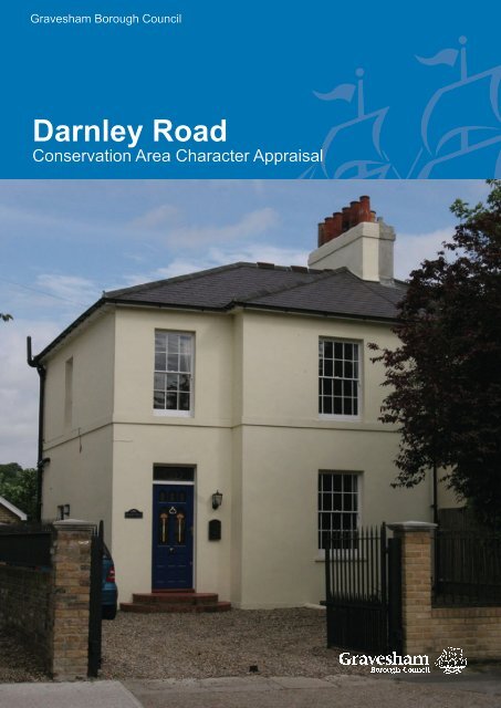
Cover: <strong>Darnley</strong> <strong>Road</strong>, Gravesend
<strong>Darnley</strong> <strong>Road</strong> Conservation Area Appraisal 2009<br />
<strong>Darnley</strong> <strong>Road</strong><br />
Conservation Area Appraisal<br />
This document was prepared on behalf of <strong>Gravesham</strong> <strong>Borough</strong> <strong>Council</strong> based on an extensive<br />
survey dated 2007 by:<br />
The Conservation Studio<br />
1 Querns Lane<br />
Cirencester<br />
Gloucestershire<br />
GL7 1RL<br />
Tel: 01285 642428<br />
Email: info@theconservationstudio.co.uk<br />
www.theconservationstudio.co.uk<br />
Published by <strong>Gravesham</strong> <strong>Borough</strong> <strong>Council</strong> 2009
<strong>Darnley</strong> <strong>Road</strong> Conservation Area Appraisal 2009<br />
CONTENTS<br />
1 Statement of Special Interest of the Conservation Area 1<br />
2 <strong>Darnley</strong> <strong>Road</strong> Conservation Area 2<br />
2.1 Background<br />
2.2 Purpose of the appraisal<br />
2.3 Planning policy context<br />
2.4 Community Involvement<br />
3 Location and Landscape Setting 5<br />
3.1 Geographic location<br />
3.2 Activities and uses<br />
3.3 Topography<br />
3.4 Geology and Biodiversity<br />
3.5 Relationship of the Conservation Area to its surroundings<br />
4 Historical Development 7<br />
4.1 Archaeology<br />
4.2 Historical development<br />
5 Spatial Analysis 11<br />
5.1 Layout and spaces<br />
5.2 Relationship of buildings to spaces<br />
5.3 Landmarks, focal points and views<br />
5.4 Trees, boundaries and planting<br />
6 Streetscape 14<br />
6.1 Public Realm
<strong>Darnley</strong> <strong>Road</strong> Conservation Area Appraisal 2009<br />
7 The buildings of the conservation area 16<br />
7.1 Building types<br />
7.2 Building form<br />
7.3 Listed buildings<br />
7.4 Locally listed buildings<br />
7.5 Key unlisted buildings<br />
7.6 Building Materials<br />
7.7 Local Details<br />
8 Character Analysis 19<br />
8.1 Summary of character<br />
9 Issues 24<br />
9.1 Definition of issues<br />
9.2 Conservation area boundary review<br />
9.3 Education and information<br />
9.4 Uses/ vitality<br />
9.5 Enhancement potential<br />
9.6 Highways and traffic management<br />
9.7 Locally Listed buildings<br />
9.8 Trees and Landscaping<br />
Appendices 27<br />
Appendix 1<br />
Appendix 2<br />
Bibliography<br />
Townscape Appraisal Map<br />
Age of Buildings Map<br />
Designations Map<br />
Character Areas Map<br />
Conservation Area Boundary Map 2009
<strong>Darnley</strong> <strong>Road</strong> Conservation Area Appraisal 2009<br />
1<br />
1. STATEMENT OF THE<br />
SPECIAL INTEREST OF THE<br />
CONSERVATION AREA<br />
The <strong>Darnley</strong> <strong>Road</strong> Conservation Area includes<br />
part of the 19th century residential expansion<br />
around the site of the Earl of <strong>Darnley</strong>’s manor<br />
farm to the south of Gravesend town centre.<br />
The Conservation Area features two relatively<br />
distinct parts: <strong>Darnley</strong> <strong>Road</strong>, a broad highway<br />
leading south to Old <strong>Road</strong>; and Cobham<br />
Street and <strong>Darnley</strong> Street, two east-west<br />
residential roads that connect <strong>Darnley</strong> <strong>Road</strong><br />
and Wrotham <strong>Road</strong>. The special interest<br />
is provided by the historic layout, including<br />
remnants of the manor farm (the open green),<br />
since overlain with a 19th century urban street<br />
pattern. These streets contain small groups<br />
and terraces of high quality two- and threestorey<br />
19th century houses, many of which<br />
display elaborate architectural detailing.<br />
Until the end of the 18th century <strong>Darnley</strong> <strong>Road</strong><br />
was a country lane which led through fields<br />
from the riverside settlement of Gravesend to<br />
the Dover to London stagecoach route. In the<br />
early 19th century the fields became market<br />
gardens and from the mid 19th century the<br />
rural setting was transformed by the suburban<br />
expansion of Gravesend. During this period<br />
the town became a fashionable leisure resort.<br />
By the end of the 19th century most of the<br />
houses in the Conservation Area had been<br />
built. The area was served by good transport<br />
links to London, with Gravesend railway<br />
station located immediately to the north. It<br />
was a leafy suburban area, with small shops<br />
established in converted houses and a large<br />
cricket ground, the Bat and Ball, situated<br />
close by. The demolition of the Manor Farm<br />
in 1890 and the creation of a small green on<br />
its remaining land in the early 20th century<br />
completed the transformation of the area into<br />
its current suburban appearance.<br />
The buildings of the Conservation Area<br />
represent high quality 19th century<br />
architecture typical of an affluent Victorian<br />
and Edwardian suburb such as this. Many of<br />
the buildings are generously scaled terraced<br />
houses or paired villas and display a wealth<br />
of architectural ornamentation. The early<br />
houses on Cobham Street and <strong>Darnley</strong> Street<br />
are predominantly raised above a basement,<br />
with the front door approached by a flight of<br />
stone steps, thereby increasing the visual<br />
status of the buildings. In contrast, the later<br />
19th century buildings on <strong>Darnley</strong> <strong>Road</strong><br />
make a grand statement by being set within<br />
large plots, thereby reducing the density<br />
of development along this thoroughfare.<br />
These large gardens, many of which contain<br />
mature shrubs and trees, make a significant<br />
contribution to the suburban character of<br />
<strong>Darnley</strong> <strong>Road</strong>, and this is reinforced by the<br />
area of open green space at the junction with<br />
Pelham <strong>Road</strong>.
<strong>Darnley</strong> <strong>Road</strong> Conservation Area Appraisal 2009<br />
2<br />
2. DARNLEY ROAD<br />
CONSERVATION AREA<br />
2.1 Background<br />
The <strong>Darnley</strong> <strong>Road</strong> Conservation Area was<br />
designated on 1st February 1990 (extended<br />
on 14th February 2001) by <strong>Gravesham</strong><br />
<strong>Borough</strong> <strong>Council</strong>. The Conservation Area’s<br />
boundary contains <strong>Darnley</strong> <strong>Road</strong>, <strong>Darnley</strong><br />
Street and Cobham Street, as well as three<br />
houses in Pelham <strong>Road</strong>.<br />
2.2 Purpose of the appraisal<br />
This conservation area appraisal has been<br />
written by The Conservation Studio on behalf<br />
of <strong>Gravesham</strong> <strong>Borough</strong> <strong>Council</strong>. It was<br />
prepared in January 2008 and was followed<br />
by a process of community engagement,<br />
which informed the content of this document.<br />
This appraisal defines the special architectural<br />
and historic interest for which <strong>Darnley</strong> <strong>Road</strong><br />
Conservation Area merits designation. It<br />
identifies the positive features that should<br />
be protected and highlights the negative<br />
factors that detract from its character<br />
and appearance. It will be used by the<br />
<strong>Borough</strong> <strong>Council</strong> in considering proposals<br />
for demolition or alteration of buildings, as<br />
well as for new developments. It will also<br />
help property owners and developers to<br />
take account of the importance of buildings,<br />
features, spaces and landscape within and<br />
adjacent to the Conservation Area.<br />
This conservation area character appraisal<br />
and that of the two other 19th century<br />
suburban Conservation Areas in Gravesend,<br />
i.e. <strong>Darnley</strong> <strong>Road</strong> and Windmill Hill, will lead<br />
to a management plan, setting out policies<br />
and actions to conserve and enhance the<br />
special architectural and historic interest of<br />
the two conservation areas and to mitigate the<br />
effects of negative features. The appraisals<br />
and management plans are to be included<br />
as background papers in the emerging Local<br />
Development Framework (LDF) and, as such,<br />
will be a due consideration in the planning<br />
process. In due course the appraisals and<br />
management plans may also be adopted as a<br />
separate Development Plan Document within<br />
the LDF.<br />
Preparation of the appraisal involved an<br />
extensive survey of the conservation area<br />
undertaken in October 2007. The omission of<br />
any particular feature does not imply that it is<br />
of no significance.<br />
2.3 Planning policy context<br />
Conservation Areas are defined as ‘areas of<br />
architectural or historic interest the character<br />
or appearance of which it is desirable to<br />
preserve or enhance’ in the Planning (Listed<br />
Buildings and Conservation Areas) Act<br />
1990 (The Act). Local Planning Authorities<br />
are required by the Act to identify the parts<br />
of their area that should be designated as<br />
conservation areas and to formulate and<br />
publish proposals to preserve or enhance<br />
them. Local authorities must submit<br />
proposals for the protection and enhancement<br />
of conservation areas for consideration at a<br />
public meeting within the relevant area. They<br />
must also have regard to any views expressed<br />
by people attending the meeting.<br />
Broadly, the effects of designation are:<br />
• Conservation Area Consent must be<br />
obtained from the local planning authority<br />
or Secretary of State prior to the<br />
substantial or total demolition of any<br />
building or structure within a conservation<br />
area, with some exceptions;<br />
• The local planning authority must
<strong>Darnley</strong> <strong>Road</strong> Conservation Area Appraisal 2009<br />
3<br />
consider the desirability of preserving or<br />
enhancing the character or appearance<br />
of the conservation area when assessing<br />
applications for change in conservation<br />
areas;<br />
• Permitted development rights are slightly<br />
different in conservation areas;<br />
• Permission is required from the planning<br />
authority to fell or lop a tree over a certain<br />
size.<br />
Further, more detailed information is provided<br />
in the Management Plan.<br />
As well as receiving statutory protection,<br />
conservation areas are protected by regional,<br />
county and local planning policies. Relevant<br />
policies include:<br />
• Regional Planning Guidance for the South<br />
East (RPG9) (published March 2001), Key<br />
Development Principle No.9; Policy Q2;<br />
Policy Q5; Policy Q7; Policy E1.<br />
• Regional Planning Guidance 9a: The<br />
Thames Gateway Planning Framework<br />
(1995), Paras. 5.4.7 & 5.4.8: Built<br />
Heritage, Annex 1: Planning Framework<br />
Principles No.13.<br />
• Draft South East Plan (Regional Spatial<br />
Strategy) (submitted to Government<br />
on 31st March 2006), Section D8<br />
Management of the Built and Historic<br />
Environment: Policy BE1; Policy BE2;<br />
Policy BE7; Section E4 (Kent Thames<br />
Gateway).<br />
• The Kent and Medway Structure Plan<br />
(adopted 6th July 2006), Policy QL1:<br />
Quality of Development and Design;<br />
Policy QL6: Conservation Areas; Policy<br />
QL7: Archaeological Sites; Policy QL8:<br />
Buildings of Architectural or Historic<br />
Importance; Policy QL9: Historic<br />
Landscape Features; Policy QL10:<br />
Heritage Assets – Enabling Development.<br />
• <strong>Gravesham</strong> Local Plan First Review<br />
(adopted November 1994), Policy TC0,<br />
TC1, TC2, TC3, TC4, TC5, TC6, TC7,<br />
TC8, TC9, TC10, TC11, TC12, Policy R3,<br />
Proposal PM13, Policy AP3.<br />
Thames Gateway<br />
In addition to the various conservation areas<br />
in the towns, the Northfleet and Gravesend<br />
conurbation is recognised as being in a<br />
Growth Area within the Kent Thames Gateway<br />
Sub-region by the Draft South East Plan of the<br />
South East Regional Assembly. The various<br />
policy documents outlined above have, since<br />
RPG9 (1994), recognised <strong>Gravesham</strong>’s<br />
important place in the Thames Gateway<br />
(incorporating the former East Thames<br />
Corridor). RPG9a emphasizes the importance<br />
of <strong>Gravesham</strong> in achieving the Thames<br />
Gateway’s overall vision (para. 6.8.1).<br />
The Thames Gateway is an overarching<br />
term for the regeneration of large parts of<br />
East London and parts of Essex and Kent,<br />
including Gravesend. The Thames Gateway<br />
London Partnership estimates that the<br />
expected investment in the whole region will<br />
provide 150,000 jobs and 200,000 homes<br />
over the next 10 years. The large scale of<br />
this scheme will see a great deal of change<br />
across the area, including the introduction<br />
of new transport infrastructure including a<br />
Channel Tunnel Rail link (with a proposed<br />
connection to Gravesend) and major road<br />
building schemes such as the widening of the<br />
A2 south of the town.<br />
The policies included in the local and regional<br />
guidance, as outlined above, seek to guide<br />
this period of change and the specified<br />
policies all recognise the importance of<br />
retaining <strong>Gravesham</strong>’s heritage.<br />
The Management Plan that accompanies
<strong>Darnley</strong> <strong>Road</strong> Conservation Area Appraisal 2009<br />
this document will propose how <strong>Gravesham</strong>’s<br />
special character can be preserved and<br />
enhanced while these large scale changes<br />
take place.<br />
2.4 Community involvement<br />
The survey of the Conservation Area has<br />
included a process of public consultation to<br />
identify the following:<br />
• The special characteristics of <strong>Darnley</strong><br />
<strong>Road</strong> Conservation Area;<br />
• The key negative features and issues;<br />
• A range of possible actions that would<br />
mitigate or offset these detractors.<br />
The consultation began with the notification of<br />
key stakeholders in Northfleet and Gravesend<br />
at the beginning of the appraisal process.<br />
It was followed by the distribution to every<br />
property in the conservation areas of an<br />
invitation to a public meeting held on 29th<br />
November 2007. Leaflets were also displayed<br />
in public places. The meeting included<br />
a description of the principal and desired<br />
outcomes of appraisals and management<br />
plans and led into a general discussion.<br />
The meeting was attended by various<br />
representatives of the <strong>Borough</strong> <strong>Council</strong> and<br />
local interest groups.<br />
Following the meeting, the outcomes were<br />
discussed by <strong>Gravesham</strong> <strong>Borough</strong> <strong>Council</strong><br />
and The Conservation Studio. Subsequently,<br />
a period of full public consultation was held<br />
after which revisions were made to arrive<br />
at this final agreed document. A Public<br />
Consultation Report is attached to this<br />
document as Appendix 3 for information.<br />
4
<strong>Darnley</strong> <strong>Road</strong> Conservation Area Appraisal 2009<br />
5<br />
3. LOCATION AND LANDSCAPE SETTING<br />
3.1 Location<br />
Gravesend is the administrative capital of the<br />
<strong>Borough</strong> of <strong>Gravesham</strong> in north-west Kent.<br />
The <strong>Borough</strong> is generally rural in appearance<br />
with a number of attractive historic villages;<br />
Northfleet and Gravesend form the only urban<br />
areas in the locality.<br />
Gravesend is about 35 kilometres to the<br />
east of central London, with Canterbury<br />
approximately 65 kilometres to the south and<br />
east. The A2 and M2 trunk roads link these<br />
locations, and because of the proximity of the<br />
M25 and M20 motorways, and the rail link to<br />
the Channel Tunnel, Gravesend is very well<br />
connected to other parts of the country and<br />
beyond.<br />
The Oxford Archaeological Unit’s Kent<br />
Historic Landscape Characterisation (2001),<br />
commissioned by Kent County <strong>Council</strong> and<br />
English Heritage, notes that: “The process<br />
of 19th and 20th century urbanisation is<br />
particularly marked in the northern areas of<br />
Kent”. Within this study, the Dartford and<br />
<strong>Gravesham</strong> Conurbation is characterised as<br />
“a well defined urban conurbation with some<br />
limited marshland and horticulture along its<br />
edges”.<br />
The <strong>Darnley</strong> <strong>Road</strong> Conservation Area abuts<br />
the south west of Gravesend town centre. It<br />
is characterised by 19th century suburban<br />
residential development in <strong>Darnley</strong> <strong>Road</strong>,<br />
<strong>Darnley</strong> Street and Cobham Street. The<br />
eastern part of the Conservation Area adjoins<br />
the Upper Windmill Street Conservation Area.<br />
The western boundary of the Conservation<br />
Area is contiguous with the Pelham <strong>Road</strong>/The<br />
Avenue Conservation Area.<br />
3.2 Activities and uses<br />
The Conservation Area is predominantly<br />
residential, although there are some shops<br />
and other commercial activities around the<br />
junction of Pelham <strong>Road</strong> and <strong>Darnley</strong> <strong>Road</strong>.<br />
Most of the buildings were constructed as<br />
substantial single family dwellings, but many<br />
have since been subdivided into smaller units,<br />
notably those on Cobham Street and <strong>Darnley</strong><br />
Street.<br />
Buildings in commercial use include some late<br />
19th century houses which have had shops<br />
inserted at ground floor level; these shops<br />
form a small parade fronting a wide stretch<br />
of pavement created through the removal of<br />
the original boundary treatments to the front<br />
areas of these houses. Commercial activities<br />
include a dental surgery, a financial services<br />
company, a car hire firm, a laundrette, a<br />
newsagent, a restaurant, a boutique and<br />
funeral directors. Opposite them; on the west<br />
side of <strong>Darnley</strong> <strong>Road</strong> and just outside the<br />
Conservation Area boundary is a car sales<br />
showroom with a large forecourt filled with<br />
vehicles.<br />
While there is a reasonable amount of<br />
pedestrian movement around the streets of<br />
the Conservation Area in the daytime, most<br />
of the activity is related to the car, van and<br />
lorry traffic on <strong>Darnley</strong> <strong>Road</strong>, which is usually<br />
passing through the area. The narrower side<br />
streets of Cobham Street and <strong>Darnley</strong> Street<br />
are relatively quiet although they provide<br />
connections between <strong>Darnley</strong> <strong>Road</strong> and<br />
Wrotham <strong>Road</strong> and are used by occasional<br />
traffic via a one way system.<br />
3.3 Topography<br />
This part of Gravesend is relatively flat and<br />
the <strong>Darnley</strong> <strong>Road</strong> Conservation Area has
<strong>Darnley</strong> <strong>Road</strong> Conservation Area Appraisal 2009<br />
few changes in topography. The land to<br />
the east of the Conservation Area climbs<br />
gradually along Upper Windmill Street to the<br />
high ground of Windmill Hill. To the north of<br />
the Conservation Area the ground eventually<br />
slopes down to the river Thames.<br />
The main routes in the Conservation Area are<br />
generally very straight and wide, particularly<br />
<strong>Darnley</strong> <strong>Road</strong>, which is one of the principal<br />
arterial routes into Gravesend from the south.<br />
3.4 Geology and Biodiversity<br />
Gravesend lies on a thick belt of chalk that is<br />
the most significant geological trademark of<br />
this part of Kent. Otherwise, the geology of<br />
Kent is varied and lies on a “crumpled dome”<br />
of sedimentary rock which also lies under<br />
Sussex and Surrey. The dome’s peak has<br />
eroded, exposing the rocks below, while the<br />
chalk along the edge has been more resilient<br />
to erosion and has created the North Downs<br />
in Kent and South Downs in Sussex The area<br />
between the two is the Weald, notable for its<br />
heavy clays and sandstone outcrops.<br />
The abundant availability of chalk in<br />
Gravesend and Northfleet has had a<br />
considerable effect on the area as it has<br />
been excavated for many centuries and<br />
used for various activities associated with<br />
the construction of buildings. While chalk<br />
itself is too soft to be used for building large<br />
structures, it supplied the raw materials for<br />
lime and, later, for cement.<br />
3.5 Relationship of the Conservation Area to<br />
its surroundings<br />
The Conservation Area is surrounded by<br />
an urban townscape, with the following<br />
features forming the immediate setting of the<br />
Conservation Area:<br />
• To the south: The continuation of <strong>Darnley</strong><br />
<strong>Road</strong> leading down to Old <strong>Road</strong>, featuring<br />
mainly late 19th and early 20th century<br />
houses as well as some post-war infill<br />
development;<br />
• To the west: The residential houses in the<br />
Pelham <strong>Road</strong>/The Avenue Conservation<br />
Area;<br />
• To the north west: Modern commercial<br />
uses frame this setting of the Conservation<br />
Area with views across to the two towers<br />
of a factory in Northfleet;<br />
• To the north: Gravesend Transport Quarter<br />
and Gravesend historic town centre and<br />
riverside beyond;<br />
• To the east: The Civic Centre and<br />
Woodville Hall and the residential houses<br />
in the Upper Windmill Street Conservation<br />
Area.<br />
The settlement lies close to good sources<br />
of sand and these, which together with<br />
the London Clay found on the nearby Hoo<br />
Peninsula to the east, provided the raw<br />
materials for brick making.<br />
6
<strong>Darnley</strong> <strong>Road</strong> Conservation Area Appraisal 2009<br />
7<br />
4 HISTORICAL DEVELOPMENT<br />
4.1 Archaeology<br />
Evidence of prehistoric activity in and around<br />
Gravesend and Northfleet is rich. Many<br />
finds from the lower Palaeolithic period<br />
having been made in the Ebbsfleet valley<br />
including the richest Levallois site in Britain<br />
(containing distinctive knapped flints), and<br />
there have been prehistoric finds of flint<br />
axes and pottery sherds. The remains of a<br />
substantial Roman villa complex has been<br />
discovered in Northfleet and evidence of a<br />
former Roman road was found close to the<br />
river in Gravesend. The most important and<br />
extensive local excavation in recent years,<br />
at nearby Springhead on the path of the new<br />
Channel Tunnel Rail Link, has uncovered the<br />
Roman town of Vagniacae, a former Iron Age<br />
settlement that the Romans occupied in 43<br />
AD. A hoard of 552 Saxon coins and a silver<br />
cross were found in 1838 to the south of the<br />
Conservation Area.<br />
The <strong>Darnley</strong> <strong>Road</strong> Conservation Area is<br />
not within any of Kent County <strong>Council</strong>’s<br />
designated Areas of Archaeological Potential.<br />
4.2 Historical development<br />
<strong>Darnley</strong> <strong>Road</strong> and the surrounding area<br />
developed as part of the suburban expansion<br />
of Gravesend during the first half of the<br />
19th century. The development occurred<br />
in incremental stages along <strong>Darnley</strong> <strong>Road</strong>,<br />
which, until the close of the 18th century, had<br />
been a lane (Ruck’s Lane, after Lawrence<br />
Ruck, a grocer who lived at Ruckland Hall)<br />
connecting the riverside town of Gravesend to<br />
the Dover to London stagecoach route which<br />
ran along Old <strong>Road</strong>. The lane lay within a<br />
field and was closed by gates at either end;<br />
in 1797 the Vestry ordered the gates to be<br />
removed. The <strong>Darnley</strong> <strong>Road</strong> Conservation<br />
Area forms part of the southern suburbs of<br />
Gravesend, whose historical development<br />
has been covered in detail in a variety of<br />
publications, details of which are included in<br />
the bibliography at the end of this document.<br />
The name “Gravesend” is derived from<br />
<strong>Gravesham</strong>, itself meaning “graaf-ham”, the<br />
home of the reeve or bailiff of the Lord of the<br />
Manor. The earliest written recording of the<br />
settlement is a reference to <strong>Gravesham</strong> in<br />
The Domesday Book of 1086, which attributes<br />
ownership of this agricultural estate to Odo,<br />
Bishop of Bayeux (the brother of William I). It<br />
noted that the Manor had been split under the<br />
ownership of three Saxon thanes (or lords)<br />
before 1066. The Saxon settlement had grown<br />
around the Old Dover <strong>Road</strong> where the Parish<br />
Church of St Mary was built. It is thought<br />
that this Parish Church lay close to Bycliffe<br />
Terrace, off Pelham <strong>Road</strong> and immediately<br />
to the west of the Conservation Area. The<br />
settlement surrounding the church remained<br />
rural through the centuries. With the granting<br />
of the first market charter in 1356, a market<br />
was located on the corner of High Street and<br />
West Street, providing a new focus for the<br />
town closer to the river and away from the<br />
Parish Church inland. This development led<br />
to the redundancy of the church and instead<br />
a chapel was built behind High Street in 1544;<br />
the chapel was located on the present day site<br />
of the Parish Church of St George. St Mary’s<br />
fell into ruin during the 16th century and in<br />
1797 the ruins and the churchyard walls were<br />
removed by a tenant of Manor Farm.<br />
Within the Conservation Area, at the junction<br />
of Pelham <strong>Road</strong> and <strong>Darnley</strong> <strong>Road</strong>, lay Manor<br />
Farm. This was the farmstead for Gravesend<br />
Manor Farm which belonged to the Earl of<br />
<strong>Darnley</strong>; the tenant farmed the land from the<br />
Northfleet boundary to Windmill Street. A large
<strong>Darnley</strong> <strong>Road</strong> Conservation Area Appraisal 2009<br />
8<br />
triangular pond lay at the junction. The farm<br />
can clearly been seen on the First Edition<br />
Ordnance Survey map of 1870, with buildings<br />
ranged around three sides of a courtyard, and<br />
an area or orchard lying to the south. Manor<br />
Farm was almost completely demolished in<br />
1890, and the surviving granary burnt down in<br />
1911.<br />
The area around <strong>Darnley</strong> <strong>Road</strong> was used for<br />
market gardens and open fields during the<br />
19th century. For example, in 1810 James<br />
Clarke opened a nursery on five acres of land<br />
between Wrotham <strong>Road</strong> and <strong>Darnley</strong> <strong>Road</strong>.<br />
The suburban development of Gravesend<br />
gradually encroached on these fields and<br />
gardens. The east side of <strong>Darnley</strong> <strong>Road</strong> was<br />
fully occupied by houses along the central<br />
stretch of road by 1870, while there were no<br />
buildings, aside from Manor Farm, located<br />
on the west side of the road at this date. The<br />
land between <strong>Darnley</strong> <strong>Road</strong> and Wrotham<br />
<strong>Road</strong> had been laid out with side streets<br />
many of which had been developed as a part<br />
of the residential suburb. In 1870 houses<br />
had been laid out along the north side of<br />
Cobham Street, but <strong>Darnley</strong> Street was yet to<br />
be divided into plots and developed. By the<br />
1897 Ordnance Survey the streets had been<br />
developed in a pattern recognisable today.<br />
With the suburban development of Gravesend<br />
during the 19th century, large singleoccupancy<br />
dwellings were erected. Today, the<br />
buildings are predominantly subdivided into<br />
smaller units. It is likely that this subdivision<br />
began to occur in the early 20th century,<br />
reflecting the social changes of that time.<br />
Within the Conservation Area there are also a<br />
number of small houses which were erected<br />
post-war, as infill on plots not previously<br />
developed, or on which properties had been<br />
bomb damaged.
<strong>Darnley</strong> <strong>Road</strong> Conservation Area Appraisal 2009<br />
<strong>Darnley</strong> <strong>Road</strong> - 1843-1893<br />
9
<strong>Darnley</strong> <strong>Road</strong> Conservation Area Appraisal 2009<br />
<strong>Darnley</strong> <strong>Road</strong> - 1891-1912<br />
<strong>Darnley</strong> <strong>Road</strong> - post 1904<br />
1891 - 1912<br />
<strong>Darnley</strong> <strong>Road</strong> - 1919-1943<br />
Post 1904<br />
10<br />
t1919-1943
<strong>Darnley</strong> <strong>Road</strong> Conservation Area Appraisal 2009<br />
11<br />
5 SPATIAL ANALYSIS<br />
5.1 Layout and spaces<br />
<strong>Darnley</strong> <strong>Road</strong> is one of a number of former<br />
country lanes that has connected the old<br />
London to Dover road (Old <strong>Road</strong>) and the<br />
centre of Gravesend since at least medieval<br />
times. A main north-south route (Wrotham<br />
<strong>Road</strong>) runs to the east and connects with the<br />
Town Pier on the Thames riverside; the lane<br />
to the west (Pelham <strong>Road</strong>) led to St Mary’s<br />
Parish Church which, until the 16th century,<br />
stood close to the Old <strong>Road</strong>.<br />
The northern end of the Conservation Area<br />
contains the junction of <strong>Darnley</strong> <strong>Road</strong> and<br />
Pelham <strong>Road</strong>; the Earl of <strong>Darnley</strong>’s manor<br />
house was once located here on the site of<br />
no. 2 Pelham <strong>Road</strong>. <strong>Darnley</strong> <strong>Road</strong> forks at<br />
a small triangular green, with the eastern<br />
branch of the road continuing southwards<br />
as <strong>Darnley</strong> <strong>Road</strong> and the western branch<br />
being Pelham <strong>Road</strong>. The green was originally<br />
part of the ponds and garden of the Manor<br />
Farm. It is the only public open space in the<br />
Conservation Area. The junction of the two<br />
roads is broad and this sense of spaciousness<br />
is increased by a further wide junction with the<br />
side street that is Cobham Street. To the south<br />
of Cobham Street, <strong>Darnley</strong> Street runs parallel<br />
with it and was laid out in the 19th century to<br />
provide an alternative route for the increasing<br />
traffic.<br />
<strong>Darnley</strong> <strong>Road</strong> leads south with a fairly<br />
continuous built form of paired villas and short<br />
terraces. It is regularly interrupted by junctions<br />
with the neighbouring residential streets,<br />
particularly on the eastern side, which connect<br />
through to Wrotham <strong>Road</strong>. Buildings are<br />
predominantly set back from the thoroughfare<br />
behind generous front gardens; the gardens<br />
become increasingly spacious as the road<br />
progresses southwards away from the town<br />
centre. <strong>Darnley</strong> <strong>Road</strong> is fairly broad and<br />
straight while the connecting roads (Cobham<br />
Street, <strong>Darnley</strong> Street, Spencer Street, Arthur<br />
Street, Trafalgar <strong>Road</strong> and Lennox <strong>Road</strong><br />
East) are all narrower, more secondary routes.<br />
5.2 Relationship of Buildings to Spaces<br />
The relationship of buildings to spaces in<br />
<strong>Darnley</strong> <strong>Road</strong>, which forms the greater part<br />
of the Conservation Area, is characterised<br />
by the wide road lined by similarly wide<br />
pavements. This is bordered on either side<br />
by large houses, set back from the pavement<br />
behind front gardens. The buildings at the<br />
northern end of <strong>Darnley</strong> <strong>Road</strong>, nos. 13-27,<br />
are set close to or at back of pavement line;<br />
there are a few surviving front areas bounded<br />
by railings, but otherwise the boundaries<br />
have been removed to create an area of<br />
hardstanding in front of a small parade of<br />
shops. The groups of buildings on <strong>Darnley</strong><br />
<strong>Road</strong> are separated by the junctions with<br />
roads on both east and west sides, as well<br />
as the gap site to the north of no.76 <strong>Darnley</strong><br />
<strong>Road</strong>.<br />
Most of the buildings in <strong>Darnley</strong> <strong>Road</strong> were<br />
built on narrow plots and grouped in pairs<br />
or short terraces. Plot sizes on the western<br />
side of <strong>Darnley</strong> <strong>Road</strong> are noticeably more<br />
generous in terms of both depth and width<br />
than those to the east, with no. 76 being a<br />
particularly wide plot. Here the house, until<br />
recently, has been particularly imposing, as<br />
was befitting the larger garden. This effect<br />
might in future no longer be appreciated to<br />
the same extent since the gap between no.<br />
76 and no. 78 was in the process of being<br />
infilled at the time of survey. Many of the<br />
gaps between the 19th century buildings<br />
have been infilled with extensions, or standalone<br />
buildings such as the flats between
<strong>Darnley</strong> <strong>Road</strong> Conservation Area Appraisal 2009<br />
12<br />
nos. 85 and 87. A narrow back lane runs<br />
along the rear of the plots to nos. 69-105<br />
<strong>Darnley</strong> <strong>Road</strong>, providing access to a number<br />
of outbuildings situated at the end of these<br />
gardens. Redevelopment of the land to the<br />
east of the lane, outside of the Conservation<br />
Area boundary, has eroded any sense of<br />
continuous enclosure to this side of the lane.<br />
Cobham Street and <strong>Darnley</strong> Street are mainly<br />
filled with continuous rows of terraced houses<br />
or tightly grouped paired villas. The visual<br />
effect of the concentrated placement of the<br />
buildings in these two roads is accentuated<br />
by the narrow front gardens, the height of<br />
the buildings (typically of two or three storeys<br />
over a raised basement), the kerbside parking<br />
of vehicles; and the narrower streets and<br />
pavements. <strong>Darnley</strong> Street has a slightly<br />
more spacious appearance, due to the lesser<br />
height of some of the buildings, and breaks<br />
in the building line, such as at the entrance to<br />
Brandon Street.<br />
5.3 Landmarks, focal points and views<br />
The special interest in the <strong>Darnley</strong> <strong>Road</strong><br />
Conservation Area is largely created by the<br />
group value of its buildings, their relative<br />
positions to each other, and their architectural<br />
features rather than the landmark qualities of<br />
specific buildings. However, some individual<br />
buildings do make a significant impact on the<br />
streetscene and therefore can be described<br />
as ‘landmarks’:<br />
• No. 55 <strong>Darnley</strong> Street (former Primitive<br />
Methodist Chapel);<br />
• Nos.29 and 31 <strong>Darnley</strong> <strong>Road</strong>;<br />
• Nos. 65 and 67 <strong>Darnley</strong> <strong>Road</strong>;<br />
• Nos. 69 and 71 <strong>Darnley</strong> <strong>Road</strong>;<br />
These landmark buildings, as identified above,<br />
provide focal points within the Conservation<br />
Area through their position as individual or<br />
corner buildings. There are important long<br />
views along the straight, broad <strong>Darnley</strong> <strong>Road</strong>,<br />
which encompass the fine mid- to late-19th<br />
century houses which line it.<br />
Due to the relatively close proximity of<br />
buildings to one another and the flat<br />
topography, the views into and out of the<br />
Conservation Area are limited to the vistas<br />
along roads and across the main road junction<br />
at the green, from where the factories of<br />
Northfleet in the north-west are visible. The<br />
principal positive views are:<br />
• Along <strong>Darnley</strong> <strong>Road</strong>, Cobham Street and<br />
<strong>Darnley</strong> Street in both directions;<br />
• Along Lennox <strong>Road</strong> East;<br />
• No.2 Pelham <strong>Road</strong> from the northern<br />
boundary of the Conservation Area;<br />
• Nos. 67 to 79 from the north-west.<br />
5.5 Trees, boundaries and planting<br />
There are a number of mature trees in<br />
the front gardens of properties in <strong>Darnley</strong><br />
<strong>Road</strong>. These provide an increased sense of<br />
enclosure in this suburban thoroughfare and<br />
serve to soften the hard edges of the urban<br />
landscape. Tree groups are most noticeable<br />
around the front boundary to the empty plot<br />
between nos. 74-76, and in the rear gardens<br />
of nos. 2-6 Pelham <strong>Road</strong> which back onto<br />
<strong>Darnley</strong> <strong>Road</strong>. There are further important<br />
individual trees in a number of the front<br />
gardens on <strong>Darnley</strong> <strong>Road</strong>.<br />
There is a noticeable absence of street trees<br />
in the Conservation Area except in Lennox<br />
<strong>Road</strong> East where they have been severely<br />
lopped. There are no trees at all in Cobham<br />
Street, and very few in <strong>Darnley</strong> Street.<br />
Important trees are marked on the Townscape<br />
Appraisal map.
<strong>Darnley</strong> <strong>Road</strong> Conservation Area Appraisal 2009<br />
All of the residential buildings in the<br />
Conservation Area stand behind front gardens<br />
or front areas giving access to the basement<br />
areas. The plots are edged by a variety of<br />
boundary treatments, comprising a mixture<br />
of brick walls, railings, timber fencing and<br />
trees or hedging. Traditionally, most of the<br />
boundaries were formed by dwarf walls of<br />
stone or rendered brick surmounted by cast<br />
iron railings. Cobham Street in particular<br />
retains many of the original decorative cast<br />
iron railings, together with some examples of<br />
high-quality modern replacements. <strong>Darnley</strong><br />
Street also retains attractive stretches of cast<br />
iron railings, with a floral head detail, but<br />
many of the boundary treatments have been<br />
demolished or replaced with inappropriate late<br />
20th century brick walls. Many of the houses<br />
on these two streets are approached up a set<br />
of stone steps, and in a number of instances<br />
these are edged by decorative cast-iron<br />
railings and handrails, such as can be seen at<br />
nos. 37-38 Cobham Street. The frontages of<br />
the properties in these streets are too shallow<br />
to allow for any vehicular hardstandings,<br />
and in some cases contain basement<br />
accommodation access, so the integrity and<br />
continuity of the boundary treatments has<br />
survived to a much greater degree than in<br />
<strong>Darnley</strong> <strong>Road</strong>.<br />
the provision of areas of hardstanding, for<br />
example to the front of nos. 21-27, which has<br />
provided an area of car parking in front of a<br />
small parade of shops.<br />
Most of the significant planting in the<br />
Conservation Area can be seen in private<br />
gardens. The triangular green on the corner<br />
of Pelham <strong>Road</strong> features a small area of<br />
raised bedding in the centre of the lawn, but<br />
no trees or other planting.<br />
13<br />
One of the few surviving 19th century<br />
boundary treatments in <strong>Darnley</strong> <strong>Road</strong> is<br />
at <strong>Darnley</strong> House (no.41), and consists of<br />
low rendered brick wall topped with cast<br />
iron railings. The original gate piers remain.<br />
However, most of the original boundary<br />
treatments to houses on this road have been<br />
replaced with modern railings or hedging,<br />
have been painted or otherwise adapted.<br />
Others have been removed altogether. These<br />
incremental changes have been detrimental to<br />
the special character of the roads. Boundary<br />
walls have also been removed to allow
<strong>Darnley</strong> <strong>Road</strong> Conservation Area Appraisal 2009<br />
6. STREETSCAPE<br />
6.1 Public realm<br />
Pavements<br />
The pavements in the <strong>Darnley</strong> <strong>Road</strong><br />
Conservation Area feature modern materials<br />
(concrete slabs, tarmac or poured concrete<br />
with concrete kerbs), although there are some<br />
remaining 19th century granite kerbs at the<br />
northern end of <strong>Darnley</strong> <strong>Road</strong>. Overall, the<br />
traditional relationship of raised pavement<br />
to road surface has been retained. The<br />
pavements are fairly wide along <strong>Darnley</strong><br />
<strong>Road</strong>, and narrower on the side streets.<br />
A fragment of historic setts survives at the<br />
junction of <strong>Darnley</strong> Street and Brandon <strong>Road</strong>.<br />
Generally these pavements are well<br />
maintained although the back lane which<br />
runs to the east of <strong>Darnley</strong> <strong>Road</strong>, between<br />
Arthur Street and Trafalgar <strong>Road</strong>, is in poor<br />
condition, with heavily patched tarmac.<br />
Street furniture, signage and other features<br />
The Conservation Area has a small amount<br />
of street furniture, which is mainly sited by the<br />
green space on the corner of Pelham <strong>Road</strong>.<br />
It includes two modern timber benches and<br />
two litter bins. At the time of survey there were<br />
also two large metal containers which were<br />
being used in association with some adjoining<br />
building work, but it is assumed that these are<br />
temporary structures. However, the habitual<br />
temporary use of the only open space in<br />
the Conservation Area for such unattractive<br />
features is detrimental to its amenity and<br />
appearance and should be avoided if<br />
possible.<br />
signage is particularly intrusive at the busy<br />
road junction of <strong>Darnley</strong> <strong>Road</strong> and Pelham<br />
<strong>Road</strong>. Granite bollards bearing the street<br />
name are also fixed to the pavement at the<br />
eastern entrance to <strong>Darnley</strong> Street and were<br />
part of a traffic calming measure linked to<br />
<strong>Gravesham</strong> <strong>Borough</strong> <strong>Council</strong>’s “Place To Live”<br />
regeneration scheme which began in 1998.<br />
There are no surviving historic road signs in<br />
the area. However, a red pillar post box at<br />
the apex of the junction of Pelham <strong>Road</strong> and<br />
<strong>Darnley</strong> <strong>Road</strong> provides an attractive focal<br />
point.<br />
Street lighting<br />
Street lighting in the Conservation Area is all<br />
modern, featuring hockey-stick style street<br />
lights on tall steel columns in <strong>Darnley</strong> <strong>Road</strong><br />
and on shorter columns in the other roads in<br />
the Conservation Area. In some cases, the<br />
taller examples visually compete with the<br />
roofline of buildings in <strong>Darnley</strong> <strong>Road</strong>, although<br />
this effect is mitigated by the considerable<br />
depth of the front gardens to the properties.<br />
Pedestrian movement and footpaths<br />
Pedestrian access throughout the<br />
Conservation Area is generally good, and is<br />
helped by the wide pavements and straight<br />
roads, although there are no actual pedestrian<br />
crossings. While there is a steady amount of<br />
vehicle traffic throughout the area, particularly<br />
around the junction of <strong>Darnley</strong> <strong>Road</strong>, Pelham<br />
<strong>Road</strong> and Cobham Street, the long sight lines<br />
throughout the area aid pedestrian movement.<br />
Also, the traffic calming scheme in <strong>Darnley</strong><br />
Street and Cobham Street has helped ease<br />
traffic volume in those streets and, therefore,<br />
made them more useable for pedestrians.<br />
14<br />
Signage, including directional signs for traffic<br />
and also shop fascias, is modern. Traffic
<strong>Darnley</strong> <strong>Road</strong> Conservation Area Appraisal 2009<br />
Traffic and parking<br />
The traffic on <strong>Darnley</strong> <strong>Road</strong> is intermittently<br />
heavy due to its location on a route into<br />
and out of Gravesend, and the traffic along<br />
Cobham Street and <strong>Darnley</strong> Street would be<br />
busier as a cut-through to Wrotham <strong>Road</strong><br />
if traffic calming measures had not been<br />
installed. The difference between the two<br />
character areas of this Conservation Area<br />
(as defined in section 8) is partly the result of<br />
the contrast between the long, busy urban/<br />
suburban corridor of <strong>Darnley</strong> <strong>Road</strong> and these<br />
shorter, less frequently used streets.<br />
On-street parking is only permitted in<br />
designated bays and this means that the<br />
south sides of both Cobham Street and<br />
<strong>Darnley</strong> Street are constantly lined with<br />
parked cars. The parking bays along <strong>Darnley</strong><br />
<strong>Road</strong> are more spaced out which, coupled<br />
with the increased width of the road, means<br />
that the presence of parked cars has a<br />
reduced visual impact on the streetscene.<br />
However, the generous front garden space<br />
has led to many frontages being converted to<br />
vehicular hardstandings, and this has resulted<br />
in the loss of many boundary treatments,<br />
trees and areas of bedding. This has had<br />
a detrimental effect on the character of<br />
this Conservation Area, particularly around<br />
the car parking infront of the shops at the<br />
northern end of <strong>Darnley</strong> <strong>Road</strong>. Some of the<br />
building plots have been large enough to<br />
accommodate garaging at the rear of the<br />
plots, with access provided by a back lane.<br />
This small scale development, while not<br />
always of an appropriate design, has allowed<br />
some cars to be removed from view.<br />
15
<strong>Darnley</strong> <strong>Road</strong> Conservation Area Appraisal 2009<br />
16<br />
7. THE BUILDINGS OF THE<br />
CONSERVATION AREA<br />
7.1 Building types<br />
The <strong>Darnley</strong> <strong>Road</strong> Conservation Area<br />
predominantly contains 19th century<br />
residential buildings, some of which are very<br />
substantial. A number of these large houses<br />
have been subdivided into flats. There are<br />
also examples of former domestic buildings<br />
which have been converted to commercial<br />
uses, such as shops; however, residential<br />
accommodation is often retained on the upper<br />
floors.<br />
There are other residential buildings in the<br />
Conservation Area which are of less historic<br />
interest and include 1950s and 1960s infill<br />
development constructed on the remaining<br />
open land between the 19th century<br />
properties. A row of such buildings lines part<br />
of the north side of <strong>Darnley</strong> Street, including<br />
no. 38.<br />
No. 55 <strong>Darnley</strong> Street is a former Methodist<br />
Chapel which was built in 1863 and is now in<br />
residential use. A small workshop lies to the<br />
north of no. 32 <strong>Darnley</strong> <strong>Road</strong>, which occupies<br />
what appears to be a former coach house to<br />
no. 6 Pelham <strong>Road</strong>.<br />
7.2 Building form<br />
The buildings of the <strong>Darnley</strong> <strong>Road</strong><br />
Conservation Area are predominantly<br />
arranged as short terraces and pairs of villas,<br />
with occasional instances of larger detached<br />
houses. The buildings are typically of two or<br />
three storeys in height, and on Cobham Street<br />
and <strong>Darnley</strong> Street are notable for being<br />
raised up above a basement by a flight of<br />
steps, which provide the approach to the front<br />
door.<br />
The buildings on Cobham Street and <strong>Darnley</strong><br />
Street, while being arranged as distinct<br />
groups, follow a coherent building line. The<br />
continuity of the building line along the street,<br />
together with the predominant common<br />
construction dates and styles, contributes to<br />
the group value of the terraces and pairs of<br />
villas. Many of the buildings have a parapet,<br />
behind which the roof is concealed, and this<br />
contributes to a strong linearity along the<br />
street. On Cobham Street, for example, the<br />
two bay two-storey buildings, arranged to<br />
classical proportions, create a regular rhythm<br />
of windows, doors and canted bays in views<br />
along the street, despite slight variances in<br />
height and design detail. This rhythm is more<br />
consistent on Cobham Street than on <strong>Darnley</strong><br />
Street, where there is greater variance<br />
between building heights and styles and<br />
more Post-WWII infill development. There is<br />
stronger coherence between the buildings at<br />
the eastern end of <strong>Darnley</strong> Street, where the<br />
terraces are longer, for examples nos. 1-12.<br />
This terrace also presents an elevation to<br />
Wrotham <strong>Road</strong>, no. 10.<br />
Paired villas and detached houses are the<br />
more common form of buildings on <strong>Darnley</strong><br />
<strong>Road</strong>, with buildings of three bays and twostoreys.<br />
Short terraces occupy nos. 13-27,<br />
45-51, and 69-85. The paired villas and<br />
detached houses are predominantly set<br />
beneath a hipped roof, which in occasional<br />
instances is pierced by gables or dormer<br />
windows, particularly at the southern end of<br />
the Conservation Area. Good examples of<br />
these features can be seen at nos. 92-94 and<br />
96-98 <strong>Darnley</strong> <strong>Road</strong>.<br />
7.3 Listed buildings<br />
There are no listed buildings in the<br />
Conservation Area.
<strong>Darnley</strong> <strong>Road</strong> Conservation Area Appraisal 2009<br />
17<br />
7.4 Locally listed buildings<br />
Government advice is that the preparation<br />
of a List of Locally Significant Buildings is a<br />
useful planning tool. “Locally Listed’ buildings<br />
are valued for their contribution to the local<br />
scene, or for their local historic associations,<br />
but are not considered to be of national<br />
importance, so they are usually not eligible<br />
for statutory listing. Policies to control them<br />
can be included in the Local Development<br />
Framework.<br />
<strong>Gravesham</strong> <strong>Council</strong> does not currently<br />
maintain a formal list of locally significant<br />
buildings (usually called the ‘Local List’)<br />
either in Gravesend or elsewhere, although<br />
all buildings that were identified in the 1974<br />
Listed Buildings Survey for their architectural<br />
or historic interest, but were not awarded<br />
a listing status, have been treated as<br />
‘Buildings of Local Interest’ ever since when<br />
considering planning applications. Following<br />
the importance the Government places in<br />
its Heritage White Paper on the compilation<br />
of Lists of Buildings of Local Interest,<br />
<strong>Gravesham</strong> <strong>Borough</strong> <strong>Council</strong>’s list is due to be<br />
reviewed soon.<br />
The Management Proposals for the<br />
Gravesend and Northfleet Conservation Areas<br />
contain a list of buildings which might be<br />
considered for inclusion in a Local List, once<br />
the <strong>Council</strong> have approved the criteria to be<br />
used for selection. All of them are considered<br />
to be key unlisted buildings.<br />
7.5 Key unlisted buildings<br />
A number of unlisted buildings have been<br />
identified as being buildings of townscape<br />
merit. Buildings identified as having<br />
‘townscape merit’ will vary, but commonly<br />
they will be good examples of relatively<br />
unaltered historic buildings where their style,<br />
detailing and building materials provides the<br />
streetscape with interest and variety. Most<br />
importantly, they make a positive contribution<br />
to the special interest of the Conservation<br />
Area. Where a building has been heavily<br />
altered, and restoration would be impractical,<br />
they are excluded. Key unlisted buildings<br />
include:<br />
• <strong>Darnley</strong> <strong>Road</strong>: All buildings except nos.<br />
81 to 85 and The Fireplace (single-storey<br />
shop extension to the front of no. 117a);<br />
• Cobham Street: All buildings except the<br />
extension to no.7 Wrotham <strong>Road</strong>;<br />
• <strong>Darnley</strong> Street: All buildings except nos.<br />
22, 23, 27, 36, 37, 38, 39, 40, 41 48;<br />
• Pelham <strong>Road</strong>: nos. 2 to 6.<br />
Government guidance in PPG15 ‘Planning<br />
and the historic environment’ advises that<br />
a general presumption exists in favour of<br />
retaining those buildings which make a<br />
positive contribution to the character or<br />
appearance of a conservation area (paragraph<br />
4.27). The guidance note states that<br />
proposals to demolish such buildings should<br />
be assessed against the same broad criteria<br />
as proposals to demolish listed buildings.<br />
7.6 Building Materials<br />
Most of the buildings in the Conservation Area<br />
are built using local materials, particularly<br />
red and yellow stock brick, although the<br />
slate which is commonly used to cover roofs<br />
was imported from elsewhere in the country,<br />
usually Wales. Another local material that is<br />
used in the Conservation Area is flint, and<br />
some remaining 19th century flint boundary<br />
walls stand next to no. 32 <strong>Darnley</strong> <strong>Road</strong>.<br />
Many of the buildings are faced in a stucco<br />
render which would have been produced
<strong>Darnley</strong> <strong>Road</strong> Conservation Area Appraisal 2009<br />
in nearby Northfleet. Northfleet was at the<br />
centre of some innovation in construction<br />
techniques in the 19th century, including the<br />
invention of Roman and Portland cements.<br />
Many cement works and chalk pits were<br />
established in the area, so it is not surprising<br />
that the Conservation Area retains buildings<br />
which use these materials. Many of the<br />
historic buildings in Cobham Street and<br />
<strong>Darnley</strong> Street are rendered, sometimes over<br />
the original facing brick, and the render is<br />
also moulded to create architectural detailing<br />
such as window surrounds and quoins. On<br />
<strong>Darnley</strong> <strong>Road</strong> there are numerous examples<br />
of distinctive brown Kentish brick, with some<br />
later red brick buildings. Decorative terracotta<br />
elements provide attractive detail on the late<br />
19th century buildings, such as crested ridge<br />
tiles, for example at nos. 92-94.<br />
• Distinctive tripartite first floor windows with<br />
thick first floor render window dressings<br />
including keystones;<br />
• Round headed ground floor windows;<br />
• Vertically sliding timber sash windows;<br />
• Pointed window arches (shops in <strong>Darnley</strong><br />
<strong>Road</strong> and a small terrace in Cobham<br />
Street)<br />
• Small dormer windows;<br />
• Brick chimney stacks;<br />
• Basement accommodation (Cobham<br />
Street)<br />
7.7 Local details<br />
Some of the details on buildings in the<br />
Conservation Area are particularly distinctive.<br />
These include:<br />
18<br />
• The use of yellow and brown stock<br />
brick, sometimes with red brick detailing<br />
(<strong>Darnley</strong> Street);<br />
• The use of stucco render either across<br />
whole facades or for details such as<br />
quoins, parapets and window surrounds;<br />
• Render faced canted bays and doorcases<br />
sometimes with dentil cornice;<br />
• Shaped gables, turrets and full height<br />
canted bays;<br />
• Slate roofs;<br />
• Steps up to front doors featuring cast iron<br />
railings and low walls (Cobham Street and<br />
<strong>Darnley</strong> Street)<br />
• Cast iron railings and low boundary walls;<br />
• Flint boundary wall outside the former<br />
coach house next to no.32 <strong>Darnley</strong> <strong>Road</strong>;<br />
• Cast iron balconies;
<strong>Darnley</strong> <strong>Road</strong> Conservation Area Appraisal 2009<br />
19<br />
8. CHARACTER AREAS<br />
8.1 Summary of Character Areas<br />
Within the present boundaries the <strong>Darnley</strong><br />
<strong>Road</strong> Conservation Area can be divided into<br />
two Character Areas according to landscape,<br />
topography, historical development, layout,<br />
building type, and uses. Positive features<br />
that contribute to the character of each area,<br />
or negative features that detract from it, are<br />
summarised at end of each section. The two<br />
Character Areas are:<br />
• Character Area 1: <strong>Darnley</strong> <strong>Road</strong><br />
• Character Area 2: Cobham Street and<br />
<strong>Darnley</strong> Street<br />
8.2 Character Area 1: <strong>Darnley</strong> <strong>Road</strong><br />
<strong>Darnley</strong> <strong>Road</strong> is one of a number of former<br />
country lanes that connected Gravesend<br />
with the former London to Dover stagecoach<br />
route. This was partly developed by the end<br />
of the 18th century (as shown on Hasted’s<br />
map of 1797) although none of the early<br />
buildings survive. Most of the buildings on the<br />
east side of <strong>Darnley</strong> <strong>Road</strong> were built by 1865<br />
and, like the late 19th century houses on the<br />
west side, hold a common position facing<br />
the broad highway from behind generous<br />
front gardens, and this regular orientation<br />
and domestic scale gives consistency to the<br />
streetscene. The current appearance of the<br />
thoroughfare has largely been in place since<br />
the road was fully developed at the end of<br />
the 19th century. Architectural interest is<br />
introduced to the character area by both the<br />
fine quality traditional materials and designs<br />
used in construction, and by the variety of<br />
styles employed by the designers of the small<br />
groups of houses.<br />
The northern end of <strong>Darnley</strong> <strong>Road</strong> has the<br />
least coherence and sense of enclosed street<br />
space given that it is dominated by the broad<br />
highways that meet at the junction of <strong>Darnley</strong><br />
<strong>Road</strong>, Pelham <strong>Road</strong> and Cobham Street.<br />
However, the striking mixture of architectural<br />
styles and the scale of the buildings on the<br />
eastern side of <strong>Darnley</strong> <strong>Road</strong> attractively<br />
frame the open green space at the junction<br />
of these routes. The Georgian-style Nos.<br />
13 to 19 <strong>Darnley</strong> <strong>Road</strong> are of three-storeys<br />
and present elegant, brick faced facades,<br />
featuring cast iron balconies, to the road. To<br />
the south lie a row of two-storey late 19th<br />
century houses, which while they have had<br />
shopfronts inserted at ground floor level,<br />
continue to make a positive contribution to<br />
the area through their well-detailed brick<br />
elevations, featuring contrast brickwork to<br />
created banding and window surround details.<br />
The four buildings are arranged in a stepped<br />
formation to address the subtle shift in the<br />
orientation of the road at this point.<br />
The entrances to Cobham Street and <strong>Darnley</strong><br />
Street more emphatically separate the small<br />
groups of tall three storey semi-detached<br />
houses that face across the triangular green.<br />
These retain details such as tripartite windows<br />
and find a number of parallels with the<br />
buildings on the two side streets.<br />
The open character of the space around<br />
the green ends at the boundary line of the<br />
garden of no. 2 Pelham <strong>Road</strong>. To the south of<br />
this, the road becomes much more enclosed<br />
by built development on either side of the<br />
thoroughfare. Part of the west side of <strong>Darnley</strong><br />
<strong>Road</strong> is not included in the Conservation<br />
Area although the late 19th century terraced<br />
houses add a certain historic character and<br />
sense of enclosure. Nos. 2-6 Pelham <strong>Road</strong><br />
are a small group of red and stock brick 19th<br />
century houses that provide a strong visual
<strong>Darnley</strong> <strong>Road</strong> Conservation Area Appraisal 2009<br />
20<br />
landmark next to the green. They mark the<br />
former site of the manor farm.<br />
On the east side of <strong>Darnley</strong> <strong>Road</strong> a range<br />
of 19th century buildings are an attractive<br />
mixture of styles and forms all standing<br />
behind front gardens in the leafiest part of<br />
the Conservation Area. Intersecting roads<br />
such as Spencer Street and Arthur Street<br />
provide breaks in the building line as well as<br />
permeability through the character area. The<br />
imposing buildings at the junction with Arthur<br />
Street architecturally stand out amonst the<br />
development along the street. One of these,<br />
no. 67, presents an elaborate stucco façade<br />
to the road, designed in a Jacobethan style,<br />
featuring hood-moulds to the windows and<br />
elaborate gables surmounted by finials. The<br />
original rendered boundary walls and gate<br />
piers survive and retain a large amount of<br />
Gothic-style cast iron railings. The eclectic<br />
range of architecture continues on the next<br />
corner where nos. 69 and 71 feature lavish<br />
stucco detailing, cast iron balconies and<br />
retain vertical sliding timber sash windows.<br />
The variety of facade treatments and window<br />
arrangements continues along the road<br />
although a fairly continuous grouping of semidetached<br />
houses leads to the southern edge<br />
of the Conservation Area.<br />
The west side of the road is lined by later 19th<br />
century houses. No. 76 is the largest house,<br />
a double fronted brown brick building with a<br />
19th century side extension which blends in<br />
with original building and stands under the<br />
same hipped slate roof. The house is simply<br />
detailed with flat window arches painted<br />
white, canted brick bays, two small dormers<br />
and a number of tall brick chimneystacks.<br />
The gap between the house and an attractive<br />
pair of late 19th century gault brick villas has<br />
recently been infilled with a new building. A<br />
vacant plot lies to the north of no. 76, and the<br />
boundary trees on this plot make an important<br />
contribution to the suburban character of the<br />
road. To the south of no. 76 are ranged tightly<br />
grouped pairs of buildings, with the exception<br />
of no. 90 which is detached. A tree-lined view<br />
along Lennox <strong>Road</strong> East contributes to the<br />
spacious, green suburban character of the<br />
area.<br />
At this southern end of the character area<br />
are found large semi-detached Edwardian<br />
houses. The architectural style and general<br />
built form of these houses are also found<br />
further to the south along <strong>Darnley</strong> <strong>Road</strong> and<br />
in The Avenue, to the west. While some of<br />
the front gardens have been lost to create<br />
areas of hardstanding for vehicle parking,<br />
historic boundary walls, often with a hedge<br />
behind, retain the distinctiveness between the<br />
public realm and private gardens, while also<br />
contributing the green suburban character of<br />
this stretch of <strong>Darnley</strong> <strong>Road</strong>.<br />
The principal positive features of Character<br />
Area 1: <strong>Darnley</strong> <strong>Road</strong> are:<br />
• Suburban character;<br />
• Variety of building form, style, scale and<br />
materials;<br />
• Arrangement of rows of semi-detached<br />
buildings or short rows of terraces facing<br />
each other across the road;<br />
• Nos. 29/31, 65/67, 69/71 and 76 <strong>Darnley</strong><br />
<strong>Road</strong> are landmark buildings;<br />
• Buildings arranged with a common<br />
building line behind front gardens;<br />
• Domestic scale of building;<br />
• Pitched or hipped roofs covered in slate or<br />
tile, sometimes with decorated ridge tiles;<br />
• Use of yellow stock and red brick,<br />
sometimes with patterning;<br />
• Use of render for window and door details;<br />
• Shaped gables, turrets and full height<br />
canted bays;
<strong>Darnley</strong> <strong>Road</strong> Conservation Area Appraisal 2009<br />
21<br />
• Gothic details on some buildings (nos. 65-<br />
67 <strong>Darnley</strong> <strong>Road</strong>);<br />
• Historic dormer windows (no. 76 <strong>Darnley</strong><br />
<strong>Road</strong>);<br />
• Sash windows, retaining their original<br />
glazing pattern and divided into small<br />
panes, giving a predominantly vertical<br />
emphasis;<br />
• Brick chimneystacks (including the row<br />
of stacks on nos. 34 to 72, which are not<br />
included in the designation);<br />
• Elaborate ironwork on top of low boundary<br />
wall outside no. 88 <strong>Darnley</strong> <strong>Road</strong>;<br />
• Cast iron balconies (nos. 13 -16 <strong>Darnley</strong><br />
<strong>Road</strong>)<br />
The principal negative features of Character<br />
Area 1: <strong>Darnley</strong> <strong>Road</strong> are:<br />
• Some modern infill (between nos. 19-21<br />
<strong>Darnley</strong> <strong>Road</strong> and behind no. 90 <strong>Darnley</strong><br />
<strong>Road</strong>) with a more horizontal emphasis<br />
and using modern materials, contrasting<br />
with the proportions and materials of the<br />
historic buildings (no. 74 <strong>Darnley</strong> <strong>Road</strong>);<br />
• Infilling of gaps between the semidetached<br />
houses;<br />
• The general appearance of the lane<br />
between Spencer Street and Arthur Street<br />
and the outbuildings and garages in the<br />
rears of <strong>Darnley</strong> <strong>Road</strong> properties at this<br />
location;<br />
• General rundown appearance of<br />
properties due to sub-division; e.g. nos.<br />
29/31 and 37/39 <strong>Darnley</strong> Rd, and No. 2-4<br />
Pelham <strong>Road</strong>;<br />
• Vacancy, or part-vacancy, and undermaintained<br />
condition of no. 84 <strong>Darnley</strong><br />
<strong>Road</strong>;<br />
• Loss of architectural features, notably<br />
sash windows;<br />
• Modern shop signage (no.31a <strong>Darnley</strong><br />
<strong>Road</strong>);<br />
• Impact of neighbouring commercial<br />
activities (car sales in <strong>Darnley</strong> <strong>Road</strong>);<br />
• The loss of original boundary treatments<br />
for vehicle access or the replacement<br />
with unsympathetic modern materials (for<br />
example the fence around the empty plot<br />
next to no.76 <strong>Darnley</strong> <strong>Road</strong>);<br />
• Loss of front gardens which have been<br />
converted to hardstandings;<br />
• Lack of continuity in the pavement<br />
surfaces;<br />
• Clutter of hydrant marker, street and traffic<br />
signs, litter bins, lamp columns, telegraph<br />
pole etc around the green;<br />
• The volume of traffic.<br />
8.3 Character Area 2: Cobham Street and<br />
<strong>Darnley</strong> Street<br />
This Character Area includes two of the short<br />
roads that adjoin <strong>Darnley</strong> <strong>Road</strong> to the east,<br />
linking through to Wrotham <strong>Road</strong>. They were<br />
laid out in the mid-19th century. Two clusters<br />
of houses (one centred on nos. 36a to 42)<br />
were built on the north side of Cobham Street<br />
by 1865, along with the buildings at the west<br />
end of the road (nos.29 and 31 <strong>Darnley</strong><br />
<strong>Road</strong>). Much of the subsequent development<br />
occurred by the close of the century.<br />
Both Cobham Street and <strong>Darnley</strong> Street are<br />
characterised by the rows of tightly packed<br />
terraces and semi-detached houses that line<br />
each side of these narrow side streets. The<br />
pavements are narrow and the buildings are<br />
set back from these public routes behind<br />
small front gardens or basement areas. The<br />
density of the development and the lack of<br />
planted gardens and trees give this character<br />
area an urban appearance. This is furthered<br />
by the views eastwards, to the busy route of<br />
Wrotham <strong>Road</strong>, and the Woodville Hall and<br />
Civic Centre. The unattractive 1960s rear<br />
extension to no. 7 Wrotham <strong>Road</strong> encroaches<br />
into the character area and detracts from
<strong>Darnley</strong> <strong>Road</strong> Conservation Area Appraisal 2009<br />
an otherwise strong continuous grouping of<br />
historic buildings along the street.<br />
While there is a near-continuous building line<br />
along the streets in this character area, the<br />
variety in scale and design of the buildings<br />
indicate the different phases of development.<br />
The oldest buildings are the two storey<br />
terraces on the north side of Cobham Street<br />
which are relatively plain in detail. The later<br />
buildings on either side feature round-headed<br />
first floor windows and more elaborate<br />
dressings. Many of the stucco-rendered<br />
houses feature detailing such as parapets and<br />
dentil cornices, providing visual interest on the<br />
upper floor levels. In addition, there are the<br />
modest late 19th century red brick houses at<br />
the west end (nos. 30-33) which add a further<br />
layer to the architectural history of the area<br />
and retain characteristic stylistic details such<br />
as pointed window arches.<br />
<strong>Darnley</strong> Street also has some imposing<br />
buildings, notably nos. 1-5 which have a<br />
strong vertical emphasis and share the style<br />
found in the contemporaneous Cobham<br />
Street and <strong>Darnley</strong> <strong>Road</strong> properties (round<br />
headed first and second floor windows with<br />
heavy dressings and keystones) as well as<br />
the addition of shaped gables at either end of<br />
the row. There is even more variety of style<br />
in <strong>Darnley</strong> Street and less enclosure as the<br />
buildings on the south side are generally two<br />
storeys and to the west they include some<br />
20th century houses. The most notable<br />
landmark is the former Methodist chapel<br />
which helps anchor this character area as part<br />
of a late 19th century development. This has<br />
recently been accompanied by a new threestorey<br />
house to its east, which has greatly<br />
reduced the size of one of the last gaps in the<br />
streetscene in this Conservation Area.<br />
The principal positive features of Character<br />
Area 2: Cobham Street and <strong>Darnley</strong> Street<br />
are:<br />
• Urban/suburban character;<br />
• Variety of building form, style, scale and<br />
materials;<br />
• Arrangement of tightly packed rows of<br />
buildings facing each other across the<br />
road;<br />
• No. 55 <strong>Darnley</strong> Street (former Methodist<br />
chapel) is a landmark building;<br />
• Buildings arranged with a common<br />
building line behind frontages with steps<br />
leading up to the front doors (Cobham<br />
Street);<br />
• Mainly a domestic scale of building;<br />
• Pitched or hipped roofs covered in slate or<br />
tile, sometimes with decorated ridge tiles;<br />
• Use of yellow stock and red brick,<br />
sometimes with patterning;<br />
• Use of stucco render (mainly on the north<br />
side of Cobham Street);<br />
• Use of stucco for window and door details.<br />
Three storey properties with rendered<br />
tripartite round headed windows to the<br />
first floor and two light round headed<br />
windows to the second floor. Also featuring<br />
dressings including quoins and keystones;<br />
• Use of shaped gables;<br />
• Use of canted bays;<br />
• Use of traditionally proportioned dormer<br />
windows (<strong>Darnley</strong> Street);<br />
• Sash windows, retaining their original<br />
glazing pattern and divided into small<br />
panes, giving a predominantly vertical<br />
emphasis;<br />
• Brick chimneystacks;<br />
• Cast iron railings on low rendered brick<br />
walls.<br />
22
<strong>Darnley</strong> <strong>Road</strong> Conservation Area Appraisal 2009<br />
The principal negative features of Character<br />
Area 2: Cobham Street and <strong>Darnley</strong> Street<br />
are:<br />
• Some poorly maintained buildings<br />
including graffiti, notably the garage to the<br />
west of no. 29 Cobham Street;<br />
• Loss of original features such as sash<br />
windows and their unsympathetic<br />
replacements;<br />
• The painting of properties in inappropriate<br />
colours;<br />
• Modern pavement treatments;<br />
• Satellite dishes on front elevations;<br />
• Loss of original boundary treatments;<br />
• General rundown appearance of<br />
properties due to sub-division; rubbish in<br />
alley next to no. 27 Cobham Street;<br />
• The appearance of parked cars lining one<br />
side of each street<br />
• The appearance of the rear extension to<br />
no.7 Wrotham <strong>Road</strong>.;<br />
• The appearance of the rear of no. 15<br />
Wrotham <strong>Road</strong>, including the modern<br />
garage;<br />
• Lack of maintenance, i.e. many of the<br />
painted elevations on buildings are in<br />
need of renewal.<br />
23
<strong>Darnley</strong> <strong>Road</strong> Conservation Area Appraisal 2009<br />
24<br />
9. ISSUES<br />
9.1 Definition of Issues<br />
The following ‘Issues’ have been identified by<br />
the appraisal process (via extensive survey<br />
work) and have been modified to include the<br />
views of the local community as part of the<br />
public consultation exercise, including a public<br />
meeting and four week period of consultation.<br />
They provide the basis for the Site Specific<br />
Actions in the Management Proposals. These<br />
issues will be subject to regular review by the<br />
<strong>Council</strong> and new ones may be added in the<br />
future.<br />
9.2 Conservation area boundary review<br />
It is suggested that there is some scope for<br />
alterations to the boundary of the <strong>Darnley</strong><br />
<strong>Road</strong> Conservation Area even though the<br />
designated area already includes much<br />
of the best preserved and architecturally<br />
most cohesive parts of the 19th and early<br />
20th century development in the area. The<br />
remaining late 19th century houses in the<br />
south of <strong>Darnley</strong> <strong>Road</strong> belong historically and<br />
architecturally to this Conservation Area and<br />
should be included. This could extend the<br />
boundary to the junction of Old <strong>Road</strong> while<br />
avoiding some of the modern development<br />
such as Weavers Close. Also, the terrace<br />
of houses nos. 34 to 72 <strong>Darnley</strong> <strong>Road</strong> have<br />
some merit as late 19th century houses,<br />
despite the loss of many original details, and<br />
have townscape value in the vistas along<br />
<strong>Darnley</strong> <strong>Road</strong>, particularly when approached<br />
from the south. They should also be<br />
considered for inclusion in the designation.<br />
Another change to the boundary that<br />
should be considered is the transfer of nos.<br />
2-6 Pelham <strong>Road</strong> to the Pelham <strong>Road</strong>/<br />
The Avenue Conservation Area, as these<br />
properties relate more to the neighbouring<br />
Conservation Area in terms of their orientation<br />
and architecture. Another option would be<br />
to combine the <strong>Darnley</strong> <strong>Road</strong> Conservation<br />
Area and the Pelham <strong>Road</strong>/The Avenue<br />
Conservation Area, a designation that would<br />
be justifiable on the grounds of the common<br />
appearance and development stages of<br />
the two areas. A new Conservation Area<br />
that encompassed all of these roads would<br />
remove the need to make arbitrary decisions<br />
on where boundaries should be drawn along<br />
connecting roads such as Lennox <strong>Road</strong> East.<br />
Finally, no.35a Arthur Street is modern infill<br />
development with no special character and<br />
should be considered for exclusion from the<br />
Conservation Area.<br />
9.3 Education and information<br />
Active measures for promoting better<br />
understanding of Gravesend and its place in<br />
history underpin the regeneration of the town<br />
by drawing in external interest and resources.<br />
<strong>Gravesham</strong> <strong>Borough</strong> <strong>Council</strong> has recently<br />
published a number of guides in order to help<br />
promote this understanding and to encourage<br />
an improvement in standards in the borough’s<br />
conservation areas. These include guidance<br />
on shopfronts, windows and doors.<br />
9.4 Uses/ vitality<br />
The late 19th century residential character of<br />
the Conservation Area suffers from the use of<br />
<strong>Darnley</strong> <strong>Road</strong> as a through route between Old<br />
<strong>Road</strong> and Gravesend town centre, as well as<br />
from some of the business uses of properties<br />
to the north and west of the Conservation<br />
Area boundary.
<strong>Darnley</strong> <strong>Road</strong> Conservation Area Appraisal 2009<br />
25<br />
Also, sub-division of properties into flats,<br />
particularly in Cobham Street and <strong>Darnley</strong><br />
Street, has led to some erosion of special<br />
character of the buildings (through lack of<br />
maintenance by landlords), their settings<br />
(through rubbish and other detritus) and<br />
increased number of parked cars (cluttering<br />
the streetscene).<br />
9.5 Enhancement potential<br />
Despite the fact that the buildings and<br />
spaces of <strong>Darnley</strong> <strong>Road</strong> Conservation Area<br />
are generally in a good repair, there is some<br />
scope for their enhancement.<br />
The following buildings and spaces require<br />
attention:<br />
• No.84 <strong>Darnley</strong> <strong>Road</strong> (appears to be<br />
vacant and has an overgrown front<br />
garden);<br />
• Infill buildings next to no.90 <strong>Darnley</strong><br />
<strong>Road</strong>;<br />
• The hardstanding area to the rear of no.<br />
2 Pelham <strong>Road</strong>;<br />
• Garages and outbuildings to the rear of<br />
<strong>Darnley</strong> <strong>Road</strong> between Spencer Street<br />
and Arthur Street;<br />
• The appearance of garages at no. 27<br />
and 31 <strong>Darnley</strong> Street, no. 29 Cobham<br />
Street (graffiti) and no.15 Wrotham <strong>Road</strong>.<br />
Also, the group of garages next to no. 48<br />
<strong>Darnley</strong> Street;<br />
• The workshop next to no. 32 <strong>Darnley</strong><br />
<strong>Road</strong>, including structural problems to<br />
the gable;<br />
• A number of painted elevations on<br />
buildings in the Conservation Area which<br />
are in need of re-painting.<br />
The following improvements would also be<br />
welcome:<br />
• Many of the boundaries would benefit<br />
from the use of more traditional materials,<br />
and the restoration of the original style of<br />
railings and low walling;<br />
• Improve the unkempt appearance of<br />
many of the front gardens, most notably in<br />
Cobham Street);<br />
• Replace the fence boundary to the vacant<br />
plot to the north of no. 76 <strong>Darnley</strong> <strong>Road</strong>.<br />
Other elements in the Conservation Area<br />
would benefit from a range of improvements:<br />
• Remove prominently located satellite<br />
dishes;<br />
• Improve the appearance and condition<br />
of pavements across the Conservation<br />
Area – for instance, the replacement of<br />
tarmac with traditional style slabs would<br />
complement the streetscene, particularly<br />
in Cobham Street and <strong>Darnley</strong> Street;<br />
• Improve planning controls over signage on<br />
commercial and civic properties;<br />
• Remove clutter around the green on the<br />
corner of Pelham <strong>Road</strong> and consider a<br />
landscaping/planting that could make the<br />
area more attractive. Also unsuitable uses<br />
such as the temporary siting of storage<br />
units should be prevented;<br />
• Consider ways to improve the existing<br />
parking arrangements outside the shops<br />
(nos. 21-27) in <strong>Darnley</strong> <strong>Road</strong>.<br />
9.6 Highways and traffic management<br />
The impact of the motorcar on the character<br />
of 19th century suburbs in general has been<br />
acute. In the <strong>Darnley</strong> <strong>Road</strong> Conservation Area<br />
it has resulted in the loss of front gardens and<br />
boundaries to create off-street car parking<br />
areas, and the crowding of the streetscene
<strong>Darnley</strong> <strong>Road</strong> Conservation Area Appraisal 2009<br />
as a result of intensive kerbside parking in<br />
others. Both of these outcomes should be<br />
monitored and reviewed.<br />
A previous traffic calming scheme in Cobham<br />
Street and <strong>Darnley</strong> Street has eased some<br />
of the highways problems in these roads,<br />
and traffic and parking is also managed<br />
effectively in <strong>Darnley</strong> <strong>Road</strong>. However, the<br />
speed and volume of traffic, the effects of car<br />
parking, and the potential introduction of new<br />
controls and highway signage in the future are<br />
important factors in the successful retention<br />
of the character and appearance of the<br />
Conservation Area. They should be taken into<br />
consideration in any future private or public<br />
realm schemes.<br />
9.7 Locally Listed buildings<br />
There is no adopted comprehensive Local List<br />
for Gravesend (nor indeed, for <strong>Gravesham</strong><br />
<strong>Borough</strong> generally) and the identification<br />
of buildings or structures for a Local List is<br />
considered to be a priority, once the criteria<br />
have been agreed. Any Local List should be<br />
drawn up with the full consultation of the local<br />
community.<br />
9.8 Trees and Landscaping<br />
Trees make an important contribution to<br />
the character of Character Area 1. Mature<br />
specimens can be seen in the central part of<br />
<strong>Darnley</strong> <strong>Road</strong> and in Lennox <strong>Road</strong> East and<br />
a Tree Management Strategy that considered<br />
issues of amenity, practicality and, importantly,<br />
sensitive lopping and succession planning,<br />
would reduce the need to take ad hoc<br />
decisions on a case-by-case basis.<br />
26
<strong>Darnley</strong> <strong>Road</strong> Conservation Area Appraisal 2009<br />
APPENDICES<br />
Appendix 1<br />
Bibliography<br />
Appendix 2<br />
Townscape Appraisal Map<br />
Age of Buildings Map<br />
Designations Map<br />
Character Areas<br />
Conservation Area Boundary Map 2009<br />
27
<strong>Darnley</strong> <strong>Road</strong> Conservation Area Appraisal 2009<br />
Appendix 1 - Bibliography<br />
Gravesend Library<br />
Gravesend Chronology 56AD – 2000<br />
2000<br />
The Architecture Centre<br />
A Business Plan for Regeneration for<br />
<strong>Gravesham</strong> <strong>Borough</strong> <strong>Council</strong><br />
2003<br />
<strong>Gravesham</strong> <strong>Borough</strong> <strong>Council</strong> <strong>Gravesham</strong><br />
Local Plan First Review 1994<br />
Riverside regeneration in <strong>Gravesham</strong><br />
1996<br />
A strategy for the Heritage Riverside<br />
1998<br />
Grierson, Douglas W<br />
Gravesend in old picture postcards<br />
1993<br />
Hiscock, Robert H<br />
A history of Gravesend 1981<br />
Gravesend in old photographs 1988<br />
Gravesend & Northfleet revisted 1998<br />
A historical walk through Gravesend and<br />
Northfleet 2006<br />
Kent County <strong>Council</strong><br />
Kent Historic Towns Survey:<br />
Gravesend 2004<br />
Pevsner, N & Newman J<br />
Buildings of England: Kent<br />
1983<br />
Solly, Raymond<br />
Gravesend: a photographic history<br />
of your town 2002<br />
Streeter, Eve<br />
Gravesend: then & now 2001<br />
28
3<br />
2a<br />
30<br />
26<br />
2<br />
14<br />
1<br />
13<br />
23<br />
35<br />
RE<br />
I<br />
CE<br />
9<br />
6<br />
7<br />
(<br />
(<br />
<strong>Darnley</strong> <strong>Road</strong> Conservation Area Appraisal 2009<br />
29<br />
15.2m<br />
CLIVE ROAD<br />
Car Park<br />
Statue<br />
FB<br />
MP 24<br />
ROAD RROAD<br />
35S<br />
3S SL<br />
Station<br />
Gantry<br />
5<br />
Gravesend<br />
SL<br />
ST JAMES'S ROAD<br />
Gravesend Station<br />
n<br />
Cliff<br />
13 9<br />
RATHMORE<br />
MORE<br />
BM<br />
20.56m<br />
Cliff ff<br />
Station<br />
The<br />
Inn<br />
(PH)<br />
RATHMORE ROAD<br />
H)24 24<br />
13<br />
23<br />
The Lodge<br />
12<br />
20<br />
Car Park<br />
Garage<br />
Posts<br />
36a 37<br />
34<br />
30<br />
27<br />
LT<br />
Twr<br />
3 1<br />
PW<br />
56<br />
49<br />
43<br />
COBHAM STREET<br />
6<br />
to<br />
LT<br />
Twr<br />
55<br />
20.7m<br />
58<br />
Station<br />
7<br />
COBHAM STREET<br />
29<br />
LB<br />
L Twr<br />
Pond<br />
23<br />
25<br />
29<br />
7<br />
13<br />
16<br />
31<br />
Games Court<br />
1<br />
L Twr<br />
8<br />
31a<br />
2<br />
Bronte Schoolol<br />
L Twr<br />
33<br />
21.3m<br />
Posts<br />
L Twr<br />
33 39<br />
P<br />
Builder's<br />
Yard<br />
43 44<br />
41<br />
40<br />
35<br />
48<br />
55<br />
DARNLEY STREET<br />
31<br />
37<br />
15<br />
DARNLEY STREET<br />
Tank<br />
18<br />
23<br />
24<br />
20.7m<br />
07<br />
12<br />
13<br />
6<br />
1<br />
Gravesend Grammar School oolol for Girls<br />
Isaac Newton Block Block ck<br />
1<br />
12<br />
16<br />
<strong>Darnley</strong><br />
Court<br />
32<br />
21.3m<br />
Posts<br />
26<br />
27<br />
43<br />
WOODVILLE PLACE<br />
BM 21.90m<br />
6<br />
Car Park Posts<br />
21.3m<br />
19 25<br />
1 to 7<br />
43<br />
26<br />
11<br />
SPENCER STREET<br />
21.0m<br />
SPENCER<br />
STREET<br />
20<br />
18 to<br />
21<br />
6<br />
STREET<br />
BM 21.97m<br />
21.0m<br />
2<br />
45<br />
17<br />
42<br />
12<br />
17<br />
22<br />
50<br />
21.8m<br />
30<br />
52<br />
Conservation area boundary<br />
37<br />
12<br />
Briar Cottage<br />
52<br />
10<br />
34<br />
Hall<br />
ZION PLACE<br />
BRANDON STREET<br />
21.3m<br />
40<br />
CUTMORE STREET<br />
32<br />
25<br />
21.9m<br />
1<br />
1<br />
PH<br />
WROTHAM ROAD<br />
27<br />
Brandon<br />
Hall<br />
16 11<br />
21<br />
55<br />
32<br />
2<br />
14<br />
16<br />
BM 21.59m<br />
BM 22.12m<br />
2<br />
Positive buildings<br />
6<br />
Cottage<br />
Rose<br />
5<br />
CAMBRIAN GROVE<br />
LB<br />
DARNLEY ROAD<br />
62<br />
2<br />
Positive open space<br />
WEST<br />
EST<br />
ARTHUR STREET STREWES<br />
20<br />
47<br />
72<br />
CLAREMONT PLACE<br />
34<br />
2<br />
26<br />
67<br />
3<br />
37<br />
51<br />
37a<br />
25<br />
21 to 22<br />
35<br />
35a<br />
39<br />
21.0m<br />
1<br />
2<br />
44<br />
40<br />
ARTHUR STREET<br />
E<br />
30<br />
39<br />
41a<br />
1 to 19 19<br />
53<br />
69<br />
Sub bS<br />
Sta<br />
El<br />
49<br />
48<br />
The eC<br />
Cricketers<br />
74<br />
(PH)<br />
1<br />
21.9m<br />
25<br />
Victoria Avenue<br />
56<br />
34<br />
61<br />
19<br />
13<br />
25.9m<br />
38<br />
23.1m<br />
27<br />
104<br />
Posts<br />
PH<br />
49<br />
65<br />
22.6m<br />
2<br />
ARTHUR STREET<br />
ET<br />
15<br />
107<br />
to<br />
11<br />
40<br />
51<br />
10<br />
2f<br />
5 1<br />
2<br />
1 3<br />
8 6<br />
PO<br />
LB<br />
BM 24.22m<br />
The Man<br />
of Kent<br />
81 to 85<br />
6<br />
(PH)<br />
3<br />
1<br />
77 to 103<br />
87<br />
7<br />
Car Park<br />
50<br />
17<br />
15<br />
11<br />
9<br />
25<br />
23.8m<br />
61<br />
59<br />
SHEPPY PLACE<br />
LB<br />
63<br />
2 4 8 6<br />
CLIFTON GROVE<br />
38 to 49<br />
NINE NE ELMS GROVE<br />
12<br />
10<br />
76<br />
9<br />
11<br />
12<br />
58<br />
95<br />
15<br />
17<br />
34<br />
to<br />
37<br />
67<br />
60<br />
12<br />
10<br />
14<br />
16<br />
60d<br />
60c<br />
73<br />
St James Oaks<br />
24<br />
22<br />
5<br />
1<br />
10<br />
6<br />
Lydia aC<br />
Cottages<br />
11<br />
31<br />
44<br />
In terms of the current Conservation Area boundary please consult the Designated Boundary Map dated 09.02.09 included in this document<br />
Positive views<br />
Neutral open space<br />
21<br />
79<br />
Neutral views<br />
2<br />
4<br />
9<br />
Negative buildings<br />
16<br />
14<br />
50 to 76<br />
23<br />
25<br />
18<br />
20<br />
THE AVENUE<br />
Negative open space<br />
and negative townscape<br />
5 to 33<br />
Negative views<br />
10<br />
62<br />
25<br />
23<br />
1 to 4<br />
42<br />
37<br />
19<br />
21<br />
28<br />
26<br />
105<br />
20.4m<br />
20<br />
17<br />
18<br />
41<br />
24<br />
22<br />
83<br />
St James Oaks<br />
TRAFALGAR AR ROAD<br />
Significant trees/tree<br />
groups<br />
<strong>Darnley</strong><br />
Arms<br />
(PH)<br />
21.0m 10<br />
107<br />
2<br />
70<br />
Salem<br />
1<br />
6<br />
1<br />
Villas<br />
93<br />
TRAFALGAR ROAD<br />
22.5m<br />
2<br />
24.5m<br />
Wrotham <strong>Road</strong><br />
Primary School<br />
Focal buildings<br />
20<br />
18 20<br />
Surgery<br />
95<br />
Tennis<br />
Court<br />
90<br />
117<br />
117a<br />
72<br />
Bat and<br />
Ball<br />
Cricket Ground<br />
Bat and Ball Cricket Ground<br />
<strong>Gravesham</strong> <strong>Borough</strong> <strong>Council</strong><br />
107<br />
92<br />
107a<br />
Tennis<br />
Court<br />
6<br />
12<br />
23<br />
17<br />
109<br />
80<br />
Bowling Green<br />
25.0m<br />
1<br />
<strong>Darnley</strong> <strong>Road</strong> Conservation Area<br />
WINGFIELD ROAD<br />
111<br />
30<br />
25<br />
82<br />
Bat and dBll<br />
Ball<br />
(PH)<br />
19.5m<br />
177e<br />
98<br />
84<br />
Pavilion<br />
44<br />
TCB<br />
Wrotham <strong>Road</strong><br />
88<br />
Bat and Ball<br />
(PH)<br />
FS<br />
Bowling Green e F<br />
Townscape Appraisal Map<br />
Pavilion<br />
90<br />
1<br />
100<br />
3<br />
Sub Sta<br />
El<br />
bS<br />
El<br />
WEAVERS CLOSE<br />
90a<br />
Bat and<br />
Ball<br />
Cricket Ground<br />
Bat and Ball Cricket Ground<br />
Bowling Green<br />
Health Clinic<br />
90b<br />
(Not to scale)<br />
22<br />
2<br />
to 25<br />
2<br />
90c<br />
24.7m<br />
8<br />
FS<br />
FS<br />
Hall<br />
1 to 12<br />
The Pavillon<br />
Pavilion<br />
17<br />
121
3<br />
2a<br />
30<br />
26<br />
2<br />
14<br />
1<br />
13<br />
23<br />
35<br />
RE<br />
I<br />
9<br />
6<br />
ri<br />
n<br />
7<br />
(<br />
(<br />
<strong>Darnley</strong> <strong>Road</strong> Conservation Area Appraisal 2009<br />
15.2m<br />
CLIVE ROAD<br />
Car Park<br />
Statue<br />
FB<br />
MP 24<br />
ROAD RROAD<br />
35S<br />
3S SL<br />
Station<br />
Gantry<br />
5<br />
Gravesend<br />
SL<br />
ST JAMES'S ROAD<br />
Gravesend Station<br />
n<br />
Cliff<br />
13 9<br />
RATHMORE<br />
MORE<br />
BM<br />
20.56m<br />
Cliff<br />
Station<br />
The<br />
Inn<br />
(PH)<br />
RATHMORE ROAD<br />
H)24 24<br />
13<br />
23<br />
The Lodge<br />
20.4m<br />
2<br />
12<br />
20<br />
Car Park<br />
Garage<br />
Posts<br />
36a 37<br />
34<br />
30<br />
27<br />
LT<br />
Twr<br />
3 1<br />
PW<br />
56<br />
49<br />
43<br />
COBHAM STREET<br />
6<br />
to<br />
LT<br />
Twr<br />
55<br />
20.7m<br />
7<br />
58<br />
Station<br />
COBHAM STREET<br />
29<br />
LB<br />
L Twr<br />
Pond<br />
23<br />
25<br />
29<br />
7<br />
13<br />
16<br />
31<br />
Games Court<br />
1<br />
L Twr<br />
8<br />
31a<br />
2<br />
21.3m<br />
Bronte Schoolol<br />
L Twr<br />
33<br />
Posts<br />
L Twr<br />
33 39<br />
P<br />
Builder's<br />
Yard<br />
43 44<br />
41<br />
40<br />
35<br />
48<br />
55<br />
DARNLEY STREET<br />
31<br />
37<br />
15<br />
DARNLEY STREET<br />
Tank<br />
18<br />
23<br />
24<br />
20.7m<br />
07<br />
12<br />
13<br />
6<br />
1<br />
Gravesend Grammar School oolol for Girls<br />
Isaac Newton Block Block ck<br />
1<br />
12<br />
16<br />
<strong>Darnley</strong><br />
Court<br />
32<br />
21.3m<br />
Posts<br />
26<br />
27<br />
43<br />
WOODVILLE PLACE<br />
BM 21.90m<br />
6<br />
Posts<br />
21.0m<br />
Car Park<br />
21.3m<br />
19 25<br />
1 to 7<br />
43<br />
26<br />
2<br />
11<br />
SPENCER STREET<br />
P<br />
SPENCER<br />
STREET<br />
20<br />
18 to<br />
21<br />
6<br />
STREET<br />
BM 21.97m<br />
2112 12<br />
21.0m<br />
2<br />
45<br />
17<br />
42<br />
17<br />
18<br />
21<br />
22<br />
50<br />
21.8m<br />
30<br />
52<br />
37<br />
12<br />
Briar Cottage<br />
52<br />
10<br />
34<br />
Hall<br />
ZION PLACE<br />
BRANDON STREET<br />
21.3m<br />
40<br />
CUTMORE STREET<br />
32<br />
25<br />
21.9m<br />
1<br />
1<br />
PH<br />
WROTHAM ROAD<br />
27<br />
Brandon<br />
Hall<br />
16 11<br />
21<br />
55<br />
32<br />
2<br />
14<br />
16<br />
BM 21.59m<br />
BM 22.12m<br />
2<br />
6<br />
Cottage<br />
Rose<br />
CAMBRIAN GROVE<br />
LB<br />
DARNLEY ROAD<br />
62<br />
2<br />
WEST<br />
EST<br />
ARTHUR STREET STREWES<br />
20<br />
5<br />
47<br />
72<br />
CLAREMONT PLACE<br />
34<br />
2<br />
26<br />
67<br />
3<br />
51<br />
37a<br />
37<br />
25<br />
21 to 22<br />
35<br />
35a<br />
39<br />
21.0m<br />
1<br />
2<br />
44<br />
40<br />
ARTHUR STREET<br />
E<br />
41a<br />
30<br />
39<br />
1 to 19 19<br />
53<br />
69<br />
Sub bS<br />
Sta<br />
El<br />
49<br />
48<br />
The eC<br />
Cricketers<br />
74<br />
(PH)<br />
21.9m<br />
25<br />
1<br />
Victoria ia Avenue<br />
Avenue<br />
23.1m<br />
27<br />
56<br />
34<br />
61<br />
19<br />
13<br />
25.9m<br />
38<br />
104<br />
Posts<br />
PH<br />
49<br />
65<br />
22.6m<br />
ARTHUR STREET<br />
ET<br />
15<br />
107<br />
to<br />
2<br />
11<br />
40<br />
51<br />
10<br />
2f<br />
5 1<br />
2<br />
1 3<br />
The Man<br />
of Kent<br />
8 6<br />
6<br />
PO<br />
LB<br />
BM 24.22m 22<br />
The Man<br />
of f Kent<br />
81 to 85<br />
(PH)<br />
3<br />
1<br />
77 to 103<br />
87<br />
7<br />
Car Park<br />
50<br />
17<br />
15<br />
11<br />
9<br />
25<br />
23.8m<br />
59<br />
61<br />
SHEPPY PLACE<br />
LB<br />
2 4 63<br />
8 6<br />
12<br />
CLIFTON GROVE<br />
38 to 49<br />
NINE NE ELMS GROVE<br />
12<br />
10<br />
76<br />
9<br />
11<br />
95<br />
58<br />
15<br />
17<br />
34<br />
to<br />
37<br />
67<br />
12<br />
60<br />
10<br />
14<br />
16<br />
73<br />
St James Oaks<br />
24<br />
22<br />
5<br />
60d<br />
60c<br />
1<br />
10<br />
6<br />
Lydia aC<br />
Cottages<br />
11<br />
31<br />
44<br />
30 In terms of the current Conservation Area boundary please consult the Designated Boundary Map dated 09.02.09 included in this document<br />
21<br />
P<br />
79<br />
2<br />
4<br />
9<br />
16<br />
14<br />
50 to 76<br />
23<br />
25<br />
1874 - 1907<br />
Conservation<br />
area boundary<br />
18<br />
20<br />
THE AVENUE<br />
5 to 33<br />
10<br />
25<br />
23<br />
1 to 4<br />
62<br />
42<br />
37<br />
19<br />
21<br />
28<br />
26<br />
105<br />
20.4m<br />
20<br />
17<br />
1907 - 1945<br />
Pre-1800<br />
18<br />
41<br />
24<br />
22<br />
83<br />
St James Oaks<br />
TRAFALGAR AR ROAD<br />
<strong>Darnley</strong><br />
Arms<br />
(PH)<br />
21.0m 10<br />
107<br />
2<br />
70<br />
Salem<br />
1<br />
6<br />
1<br />
Villas<br />
1800 24.5m<br />
- 1874<br />
93<br />
TRAFALGAR ROAD<br />
22.5m<br />
2<br />
45a<br />
1945 -<br />
45b<br />
Wrotham <strong>Road</strong><br />
Primary School<br />
20<br />
18 20<br />
Surgery<br />
95<br />
Tennis<br />
Court<br />
90<br />
47<br />
117<br />
117a<br />
72<br />
Bat and<br />
Ball<br />
Cricket Ground<br />
Bat and Ball Cricket Ground<br />
<strong>Gravesham</strong> <strong>Borough</strong> <strong>Council</strong><br />
107<br />
92<br />
107a<br />
Tennis<br />
Court<br />
6<br />
12<br />
23<br />
17<br />
109<br />
80<br />
Bowling Green<br />
25.0m<br />
1<br />
<strong>Darnley</strong> <strong>Road</strong> Conservation Area<br />
WINGFIELD ROAD<br />
111<br />
30<br />
25<br />
82<br />
Bat and dBll<br />
Ball<br />
(PH)<br />
19.5m<br />
177e<br />
98<br />
84<br />
Pavilion<br />
44<br />
TCB<br />
Wrotham <strong>Road</strong><br />
88<br />
Bat and Ball<br />
(PH)<br />
FS<br />
Bowling Green e F<br />
Age of Buildings Map<br />
Pavilion<br />
90<br />
1<br />
100<br />
3<br />
Sub Sta<br />
El<br />
bS<br />
El<br />
WEAVERS CLOSE<br />
90a<br />
Bat and<br />
Ball<br />
Cricket Ground<br />
Bat and Ball Cricket Ground<br />
Bowling Green<br />
Health Clinic<br />
90b<br />
(Not to scale)<br />
22<br />
2<br />
to 25<br />
2<br />
90c<br />
24.7m<br />
8<br />
FS<br />
FS<br />
Hall<br />
1 to 12<br />
The Pavillon<br />
Pavilion<br />
17<br />
121
3<br />
2a<br />
30<br />
26<br />
2<br />
14<br />
1<br />
13<br />
23<br />
35<br />
RE<br />
I<br />
9<br />
6<br />
ri<br />
n<br />
7<br />
(<br />
(<br />
<strong>Darnley</strong> <strong>Road</strong> Conservation Area Appraisal 2009<br />
15.2m<br />
CLIVE ROAD<br />
Car Park<br />
Statue<br />
FB<br />
MP 24<br />
ROAD RROAD<br />
35S<br />
3S SL<br />
Station<br />
Gantry<br />
5<br />
Gravesend<br />
SL<br />
ST JAMES'S ROAD<br />
Gravesend Station<br />
n<br />
Cliff<br />
13 9<br />
RATHMORE<br />
MORE<br />
BM<br />
20.56m<br />
Cliff<br />
Station<br />
The<br />
Inn<br />
(PH)<br />
RATHMORE ROAD<br />
H)24 24<br />
13<br />
23<br />
The Lodge<br />
20.4m<br />
2<br />
12<br />
20<br />
Car Park<br />
Garage<br />
Posts<br />
36a 37<br />
34<br />
30<br />
27<br />
LT<br />
Twr<br />
3 1<br />
PW<br />
56<br />
49<br />
43<br />
COBHAM STREET<br />
6<br />
to<br />
LT<br />
Twr<br />
55<br />
20.7m<br />
58<br />
Station<br />
7<br />
COBHAM STREET<br />
29<br />
LB<br />
L Twr<br />
Pond<br />
23<br />
25<br />
29<br />
7<br />
13<br />
16<br />
31<br />
Games Court<br />
1<br />
L Twr<br />
8<br />
31a<br />
21.3m<br />
2<br />
Bronte Schoolol<br />
L Twr<br />
33<br />
Posts<br />
L Twr<br />
33 39<br />
P<br />
Builder's<br />
Yard<br />
43 44<br />
41<br />
40<br />
35<br />
48<br />
55<br />
DARNLEY STREET<br />
31<br />
37<br />
15<br />
DARNLEY STREET<br />
Tank<br />
18<br />
23<br />
24<br />
20.7m<br />
07<br />
12<br />
13<br />
6<br />
1<br />
Gravesend Grammar School oolol for Girls<br />
Isaac Newton Block Block ck<br />
1<br />
12<br />
16<br />
<strong>Darnley</strong><br />
Court<br />
32<br />
21.3m<br />
Posts<br />
26<br />
27<br />
43<br />
WOODVILLE PLACE<br />
BM 21.90m<br />
6<br />
Posts<br />
21.0m<br />
Car Park<br />
21.3m<br />
19 25<br />
1 to 7<br />
43<br />
26<br />
2<br />
11<br />
SPENCER STREET<br />
P<br />
SPENCER<br />
STREET<br />
20<br />
18 to<br />
21<br />
6<br />
STREET<br />
BM 21.97m<br />
2112 12<br />
21.0m<br />
2<br />
45<br />
17<br />
42<br />
17<br />
18<br />
21<br />
22<br />
50<br />
21.8m<br />
30<br />
52<br />
37<br />
Area of Archaeological<br />
Potential<br />
12<br />
Briar Cottage<br />
52<br />
10<br />
34<br />
Hall<br />
ZION PLACE<br />
BRANDON STREET<br />
21.3m<br />
40<br />
CUTMORE STREET<br />
32<br />
25<br />
21.9m<br />
1<br />
1<br />
PH<br />
WROTHAM ROAD<br />
27<br />
Brandon<br />
Hall<br />
16 11<br />
21<br />
55<br />
32<br />
2<br />
14<br />
16<br />
BM 21.59m<br />
BM 22.12m<br />
2<br />
6<br />
Cottage<br />
Rose<br />
CAMBRIAN GROVE<br />
LB<br />
DARNLEY ROAD<br />
62<br />
2<br />
WEST<br />
EST<br />
ARTHUR STREET STREWES<br />
20<br />
5<br />
47<br />
72<br />
CLAREMONT PLACE<br />
34<br />
2<br />
26<br />
67<br />
3<br />
51<br />
37a<br />
37<br />
25<br />
21 to 22<br />
35<br />
35a<br />
39<br />
21.0m<br />
1<br />
2<br />
44<br />
40<br />
ARTHUR STREET<br />
E<br />
41a<br />
30<br />
39<br />
1 to 19 19<br />
53<br />
69<br />
Sub bS<br />
Sta<br />
El<br />
49<br />
48<br />
The eC<br />
Cricketers<br />
74<br />
(PH)<br />
21.9m<br />
25<br />
1<br />
Victoria ia Avenue<br />
Avenue<br />
23.1m<br />
27<br />
56<br />
34<br />
61<br />
19<br />
13<br />
25.9m<br />
38<br />
104<br />
Posts<br />
PH<br />
49<br />
65<br />
22.6m<br />
ARTHUR STREET<br />
ET<br />
15<br />
107<br />
to<br />
2<br />
11<br />
40<br />
51<br />
10<br />
2f<br />
5 1<br />
2<br />
1 3<br />
The Man<br />
of Kent<br />
8 6<br />
6<br />
PO<br />
LB<br />
BM 24.22m 22<br />
The Man<br />
of f Kent<br />
81 to 85<br />
(PH)<br />
3<br />
1<br />
77 to 103<br />
87<br />
7<br />
Car Park<br />
50<br />
17<br />
15<br />
11<br />
9<br />
25<br />
23.8m<br />
59<br />
61<br />
SHEPPY PLACE<br />
LB<br />
2 4 63<br />
8 6<br />
12<br />
CLIFTON GROVE<br />
38 to 49<br />
NINE NE ELMS GROVE<br />
12<br />
10<br />
76<br />
9<br />
11<br />
95<br />
58<br />
15<br />
17<br />
34<br />
to<br />
37<br />
67<br />
12<br />
60<br />
10<br />
14<br />
16<br />
73<br />
St James Oaks<br />
24<br />
22<br />
5<br />
60d<br />
60c<br />
1<br />
10<br />
6<br />
Lydia aC<br />
Cottages<br />
11<br />
31<br />
44<br />
31 In terms of the current Conservation Area boundary please consult the Designated Boundary Map dated 09.02.09 included in this document<br />
Listed building<br />
Buildings of local interest<br />
Scheduled Monument<br />
21<br />
P<br />
79<br />
2<br />
4<br />
9<br />
16<br />
14<br />
50 to 76<br />
23<br />
25<br />
18<br />
20<br />
THE AVENUE<br />
5 to 33<br />
10<br />
25<br />
23<br />
1 to 4<br />
62<br />
42<br />
37<br />
19<br />
21<br />
28<br />
26<br />
105<br />
20.4m<br />
20<br />
17<br />
18<br />
41<br />
24<br />
22<br />
83<br />
St James Oaks<br />
TRAFALGAR AR ROAD<br />
<strong>Darnley</strong><br />
Arms<br />
(PH)<br />
21.0m 10<br />
107<br />
2<br />
70<br />
Salem<br />
1<br />
6<br />
1<br />
Villas<br />
93<br />
TRAFALGAR ROAD<br />
22.5m<br />
2<br />
45a<br />
24.5m<br />
45b<br />
Wrotham <strong>Road</strong><br />
Primary School<br />
20<br />
18 20<br />
Surgery<br />
95<br />
Tennis<br />
Court<br />
90<br />
47<br />
117<br />
117a<br />
72<br />
Bat and<br />
Ball<br />
Cricket Ground<br />
Bat and Ball Cricket Ground<br />
<strong>Gravesham</strong> <strong>Borough</strong> <strong>Council</strong><br />
107<br />
92<br />
107a<br />
Tennis<br />
Court<br />
6<br />
12<br />
23<br />
17<br />
109<br />
80<br />
Bowling Green<br />
25.0m<br />
1<br />
<strong>Darnley</strong> <strong>Road</strong> Conservation Area<br />
WINGFIELD ROAD<br />
111<br />
30<br />
25<br />
82<br />
Bat and dBll<br />
Ball<br />
(PH)<br />
19.5m<br />
177e<br />
98<br />
84<br />
Pavilion<br />
44<br />
TCB<br />
Wrotham <strong>Road</strong><br />
88<br />
Bat and Ball<br />
(PH)<br />
FS<br />
Bowling Green e F<br />
Designations Map<br />
Pavilion<br />
90<br />
1<br />
100<br />
3<br />
Sub Sta<br />
El<br />
bS<br />
El<br />
WEAVERS CLOSE<br />
90a<br />
Bat and<br />
Ball<br />
Cricket Ground<br />
Bat and Ball Cricket Ground<br />
Bowling Green<br />
Health Clinic<br />
90b<br />
(Not to scale)<br />
22<br />
2<br />
to 25<br />
2<br />
90c<br />
24.7m<br />
8<br />
FS<br />
FS<br />
Hall<br />
1 to 12<br />
The Pavillon<br />
Pavilion<br />
17<br />
121
3<br />
2a<br />
30<br />
26<br />
2<br />
14<br />
1<br />
13<br />
23<br />
35<br />
RE<br />
I<br />
9<br />
6<br />
ri<br />
n<br />
7<br />
(<br />
(<br />
<strong>Darnley</strong> <strong>Road</strong> Conservation Area Appraisal 2009<br />
15.2m<br />
CLIVE ROAD<br />
Car Park<br />
Statue<br />
FB<br />
MP 24<br />
ROAD RROAD<br />
35S<br />
3S SL<br />
Station<br />
Gantry<br />
5<br />
Gravesend<br />
SL<br />
ST JAMES'S ROAD<br />
Gravesend Station<br />
n<br />
Cliff<br />
13 9<br />
RATHMORE<br />
MORE<br />
BM<br />
20.56m<br />
Cliff<br />
Station<br />
The<br />
Inn<br />
(PH)<br />
RATHMORE ROAD<br />
H)24 24<br />
13<br />
23<br />
The Lodge<br />
20.4m<br />
2<br />
12<br />
20<br />
Car Park<br />
Garage<br />
Posts<br />
36a 37<br />
34<br />
30<br />
27<br />
LT<br />
Twr<br />
3 1<br />
PW<br />
56<br />
49<br />
43<br />
COBHAM STREET<br />
6<br />
to<br />
LT<br />
Twr<br />
55<br />
20.7m<br />
7<br />
58<br />
Station<br />
COBHAM STREET<br />
29<br />
LB<br />
L Twr<br />
Pond<br />
23<br />
25<br />
29<br />
7<br />
13<br />
16<br />
31<br />
Games Court<br />
1<br />
L Twr<br />
8<br />
2<br />
31a<br />
21.3m<br />
2<br />
Bronte Schoolol<br />
L Twr<br />
33<br />
Posts<br />
L Twr<br />
33 39<br />
P<br />
Builder's<br />
Yard<br />
43 44<br />
41<br />
40<br />
35<br />
48<br />
55<br />
DARNLEY STREET<br />
31<br />
37<br />
15<br />
DARNLEY STREET<br />
Tank<br />
18<br />
23<br />
24<br />
20.7m<br />
07<br />
12<br />
13<br />
6<br />
1<br />
Gravesend Grammar School oolol for Girls<br />
Isaac Newton Block Block ck<br />
1<br />
12<br />
16<br />
<strong>Darnley</strong><br />
Court<br />
32<br />
21.3m<br />
Posts<br />
26<br />
27<br />
43<br />
WOODVILLE PLACE<br />
BM 21.90m<br />
6<br />
Posts<br />
21.0m<br />
Car Park<br />
21.3m<br />
19 25<br />
1 to 7<br />
43<br />
26<br />
2<br />
11<br />
SPENCER STREET<br />
P<br />
SPENCER<br />
STREET<br />
20<br />
18 to<br />
21<br />
6<br />
STREET<br />
BM 21.97m<br />
2112 12<br />
21.0m<br />
2<br />
45<br />
17<br />
42<br />
17<br />
18<br />
21<br />
22<br />
50<br />
21.8m<br />
30<br />
52<br />
37<br />
12<br />
Briar Cottage<br />
52<br />
10<br />
34<br />
Hall<br />
ZION PLACE<br />
BRANDON STREET<br />
21.3m<br />
40<br />
CUTMORE STREET<br />
32<br />
25<br />
21.9m<br />
1<br />
1<br />
PH<br />
WROTHAM ROAD<br />
27<br />
Brandon<br />
Hall<br />
16 11<br />
21<br />
55<br />
32<br />
2<br />
14<br />
16<br />
BM 21.59m<br />
BM 22.12m<br />
2<br />
6<br />
Cottage<br />
Rose<br />
CAMBRIAN GROVE<br />
LB<br />
DARNLEY ROAD<br />
62<br />
2<br />
WEST<br />
EST<br />
ARTHUR STREET STREWES<br />
20<br />
5<br />
47<br />
72<br />
CLAREMONT PLACE<br />
34<br />
2<br />
26<br />
67<br />
3<br />
51<br />
37a<br />
37<br />
25<br />
21 to 22<br />
35<br />
35a<br />
39<br />
21.0m<br />
1<br />
2<br />
44<br />
40<br />
ARTHUR STREET<br />
E<br />
41a<br />
30<br />
39<br />
1 to 19 19<br />
53<br />
69<br />
Sub bS<br />
Sta<br />
El<br />
49<br />
48<br />
The eC<br />
Cricketers<br />
74<br />
(PH)<br />
21.9m<br />
25<br />
1<br />
Victoria ia Avenue<br />
Avenue<br />
23.1m<br />
27<br />
56<br />
34<br />
61<br />
19<br />
13<br />
25.9m<br />
38<br />
104<br />
Posts<br />
PH<br />
49<br />
65<br />
22.6m<br />
ARTHUR STREET<br />
ET<br />
15<br />
107<br />
to<br />
2<br />
11<br />
40<br />
51<br />
10<br />
2f<br />
5 1<br />
2<br />
1 3<br />
The Man<br />
of Kent<br />
8 6<br />
6<br />
PO<br />
LB<br />
BM 24.22m 22<br />
The Man<br />
of f Kent<br />
81 to 85<br />
(PH)<br />
3<br />
1<br />
77 to 103<br />
87<br />
7<br />
Car Park<br />
50<br />
17<br />
15<br />
11<br />
9<br />
25<br />
23.8m<br />
59<br />
61<br />
SHEPPY PLACE<br />
LB<br />
2 4 63<br />
8 6<br />
12<br />
CLIFTON GROVE<br />
38 to 49<br />
NINE NE ELMS GROVE<br />
12<br />
10<br />
76<br />
9<br />
11<br />
95<br />
58<br />
15<br />
17<br />
34<br />
to<br />
37<br />
67<br />
12<br />
60<br />
10<br />
14<br />
16<br />
73<br />
St James Oaks<br />
24<br />
22<br />
5<br />
60d<br />
60c<br />
1<br />
10<br />
6<br />
Lydia aC<br />
Cottages<br />
11<br />
31<br />
44<br />
32 In terms of the current Conservation Area boundary please consult the Designated Boundary Map dated 09.02.09 included in this document<br />
1<br />
21<br />
P<br />
79<br />
2<br />
4<br />
9<br />
16<br />
14<br />
50 to 76<br />
23<br />
25<br />
18<br />
20<br />
THE AVENUE<br />
5 to 33<br />
10<br />
25<br />
23<br />
1 to 4<br />
62<br />
42<br />
37<br />
19<br />
21<br />
28<br />
26<br />
105<br />
20.4m<br />
20<br />
17<br />
18<br />
41<br />
24<br />
22<br />
83<br />
St James Oaks<br />
TRAFALGAR AR ROAD<br />
Character Area<br />
<strong>Darnley</strong><br />
Arms<br />
(PH)<br />
21.0m 10<br />
107<br />
2<br />
70<br />
Salem<br />
1<br />
1 <strong>Darnley</strong> <strong>Road</strong><br />
6<br />
1<br />
Villas<br />
93<br />
TRAFALGAR ROAD<br />
22.5m<br />
2<br />
45a<br />
24.5m<br />
45b<br />
Wrotham <strong>Road</strong><br />
Primary School<br />
20<br />
18 20<br />
2 Cobham Street & <strong>Darnley</strong> Street<br />
Surgery<br />
95<br />
Tennis<br />
Court<br />
90<br />
47<br />
117<br />
117a<br />
72<br />
Bat and<br />
Ball<br />
Cricket Ground<br />
Bat and Ball Cricket Ground<br />
<strong>Gravesham</strong> <strong>Borough</strong> <strong>Council</strong><br />
107<br />
92<br />
107a<br />
Tennis<br />
Court<br />
6<br />
12<br />
23<br />
17<br />
109<br />
80<br />
Bowling Green<br />
25.0m<br />
1<br />
<strong>Darnley</strong> <strong>Road</strong> Conservation Area<br />
WINGFIELD ROAD<br />
111<br />
30<br />
25<br />
82<br />
Bat and dBll<br />
Ball<br />
(PH)<br />
19.5m<br />
177e<br />
98<br />
84<br />
Pavilion<br />
44<br />
TCB<br />
Wrotham <strong>Road</strong><br />
88<br />
Bat and Ball<br />
(PH)<br />
FS<br />
Bowling Green e F<br />
Character Area Map<br />
Pavilion<br />
90<br />
1<br />
100<br />
3<br />
Sub Sta<br />
El<br />
bS<br />
El<br />
WEAVERS CLOSE<br />
90a<br />
(Not to scale)<br />
Bat and<br />
Ball<br />
Cricket Ground<br />
Bat and Ball Cricket Ground<br />
Bowling Green<br />
Health Clinic<br />
90b<br />
22<br />
2<br />
to 25<br />
2<br />
90c<br />
24.7m<br />
8<br />
FS<br />
FS<br />
Hall<br />
1 to 12<br />
The Pavillon<br />
Pavilion<br />
17<br />
121
<strong>Darnley</strong> <strong>Road</strong> Conservation Area Appraisal 2009<br />
Designated Boundary Map 09.02.09<br />
Pelham <strong>Road</strong>/The Avenue<br />
Conservation Area<br />
The Overcliffe<br />
Conservation Area<br />
Upper Windmill St.<br />
Conservation Street<br />
<strong>Darnley</strong> <strong>Road</strong> Conservation Area,<br />
Gravesend at 09.02.2009<br />
Current Conservation Area Boundary<br />
Extension to the Conservation Area 09.02.09<br />
De designation of 35a Arthur Street 09.02.09<br />
Adjoining Conservation Areas<br />
Transfer to Pelham <strong>Road</strong>/The Avenue<br />
Conservation Area 09.02.09<br />
Designation date: 01.02.1990<br />
(extended 14.02.2001 and 09.02.2009)<br />
Appraisal date: 2007<br />
Article 4(2): Yes, except '01 and '09<br />
extensions and transfer Area: 9.28ha<br />
©Crown Copyright. All rights reserved.<br />
<strong>Gravesham</strong> <strong>Borough</strong> <strong>Council</strong> Licence 100019166/09<br />
33