Airport Master Plan - City of Weslaco
Airport Master Plan - City of Weslaco
Airport Master Plan - City of Weslaco

Create successful ePaper yourself
Turn your PDF publications into a flip-book with our unique Google optimized e-Paper software.
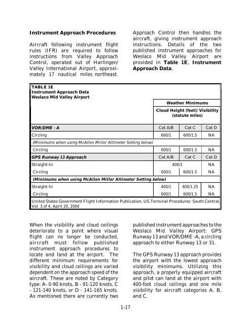
Instrument Approach Procedures<br />
Aircraft following instrument flight<br />
rules (IFR) are required to follow<br />
instructions from Valley Approach<br />
Control, operated out <strong>of</strong> Harlingen/<br />
Valley International <strong>Airport</strong>, approximately<br />
17 nautical miles northeast.<br />
Approach Control then handles the<br />
aircraft, giving instrument approach<br />
instructions. Details <strong>of</strong> the two<br />
published instrument approaches for<br />
<strong>Weslaco</strong> Mid Valley <strong>Airport</strong> are<br />
provided in Table 1E, Instrument<br />
Approach Data.<br />
TABLE 1E<br />
Instrument Approach Data<br />
<strong>Weslaco</strong> Mid Valley <strong>Airport</strong><br />
Weather Minimums<br />
Cloud Height (feet)/ Visibility<br />
(statute miles)<br />
VOR/DME - A Cat A/B Cat C Cat D<br />
Circling 600/1 600/1.5 NA<br />
(Minimums when using McAllen Miller Altimeter Setting below)<br />
Circling 600/1 600/1.5 NA<br />
GPS Runway 13 Approach Cat A/B Cat C Cat D<br />
Straight-In 400/1 NA<br />
Circling 600/1 600/1.5 NA<br />
(Minimums when using McAllen Miller Altimeter Setting below)<br />
Straight-In 400/1 400/1.25 NA<br />
Circling 600/1 600/1.5 NA<br />
United States Government Flight Information Publication, US Terminal Procedures: South Central,<br />
Vol. 3 <strong>of</strong> 4, April 20, 2000<br />
When the visibility and cloud ceilings<br />
deteriorate to a point where visual<br />
flight can no longer be conducted,<br />
aircraft must follow published<br />
instrument approach procedures to<br />
locate and land at the airport. The<br />
different minimum requirements for<br />
visibility and cloud ceilings are varied<br />
dependent on the approach speed <strong>of</strong> the<br />
aircraft. These are noted by Category<br />
type: A- 0-90 knots, B - 91-120 knots, C<br />
- 121-140 knots, or D - 141-165 knots.<br />
As mentioned there are currently two<br />
published instrument approaches to the<br />
<strong>Weslaco</strong> Mid Valley <strong>Airport</strong>: GPS<br />
Runway 13 and VOR/DME -A, a circling<br />
approach to either Runway 13 or 31.<br />
The GPS Runway 13 approach provides<br />
the airport with the lowest approach<br />
visibility minimums. Utilizing this<br />
approach, a properly equipped aircraft<br />
and pilot can land at the airport with<br />
400-foot cloud ceilings and one mile<br />
visibility for aircraft categories A, B,<br />
and C.<br />
1-17