

Plate Tectonics and the Gulf of California Region - The Arizona ...
Plate Tectonics and the Gulf of California Region - The Arizona ...
Plate Tectonics and the Gulf of California Region - The Arizona ...

Create successful ePaper yourself
Turn your PDF publications into a flip-book with our unique Google optimized e-Paper software.
Vol. 20, No.2 Investigations • Service • Infonnation Summer 1990<br />
<strong>Plate</strong> <strong>Tectonics</strong> <strong>and</strong> <strong>the</strong> <strong>Gulf</strong> <strong>of</strong><br />
<strong>California</strong> <strong>Region</strong><br />
by Nancy Schmidt<br />
<strong>Arizona</strong> Geological Survey<br />
<strong>The</strong> <strong>Gulf</strong> <strong>of</strong> <strong>California</strong>, familiar to many <strong>Arizona</strong>ns as a recreationmecca<br />
<strong>and</strong>importantpart<strong>of</strong>Mexico'sfishing <strong>and</strong>touristindustries,<br />
is unusualinterms <strong>of</strong>its depth, tidal range, salinity, temperature,<br />
<strong>and</strong> marine life. Many <strong>of</strong> <strong>the</strong> singular features <strong>of</strong> <strong>the</strong> <strong>Gulf</strong> <strong>of</strong><br />
<strong>California</strong> (also knownas <strong>the</strong>Sea <strong>of</strong>Cortez) maybe explainedbyits<br />
shape <strong>and</strong> bottom pr<strong>of</strong>ile, both <strong>of</strong>which are reflections <strong>of</strong><strong>the</strong> gulf's<br />
geologic history. This article summarizes<strong>the</strong> uniquefeatures <strong>of</strong><strong>the</strong><br />
gulf, describes <strong>the</strong> <strong>the</strong>ory <strong>of</strong> plate tectonics, explains how tectonics<br />
may have affected <strong>the</strong> geologic evolution <strong>and</strong> physiography <strong>of</strong><strong>the</strong><br />
gulf, <strong>and</strong> illustrates <strong>the</strong> process by which <strong>the</strong> Colorado River<br />
became linked to <strong>the</strong> gulf.<br />
Natural Features <strong>of</strong> <strong>the</strong> <strong>Gulf</strong><br />
<strong>The</strong> <strong>Gulf</strong> <strong>of</strong> <strong>California</strong> is approximately 1,100 kilometers in<br />
length<strong>and</strong> ranges from 48 to 241 kilometers inwidth (Figures1 <strong>and</strong><br />
2). Its long <strong>and</strong> narrowshape influences its tidalrange, which is <strong>the</strong><br />
third highest in <strong>the</strong> world <strong>and</strong> can reach almost 10 meters in <strong>the</strong><br />
nor<strong>the</strong>rn section (Flessa <strong>and</strong> Eckdale, 1987). <strong>The</strong> shape <strong>of</strong><strong>the</strong> gulf<br />
is analogous to a bathtub, <strong>and</strong> <strong>the</strong> tides, which are greatest at <strong>the</strong><br />
nor<strong>the</strong>rn <strong>and</strong> sou<strong>the</strong>rn ends <strong>and</strong> almost nonexistent in<strong>the</strong> middle,<br />
resemble water in a bathtub that sloshes back <strong>and</strong> forth when disturbed.<br />
<strong>The</strong> high salinities <strong>and</strong> temperatures <strong>of</strong><strong>the</strong> shallow water in <strong>the</strong><br />
gulf are partially due to its shape, which restricts interchange <strong>of</strong><br />
water between <strong>the</strong> gulf <strong>and</strong> Pacific Ocean. Salinities vary from 36<br />
to 39 parts per thous<strong>and</strong>. (<strong>The</strong> salinity <strong>of</strong> normal seawater is<br />
approximately 35 parts perthous<strong>and</strong>.) In<strong>the</strong> nor<strong>the</strong>rngulf, surface<br />
watertemperaturesrangefrom approximately31 0 in<strong>the</strong> summerto<br />
11 0 in <strong>the</strong> winter (Brusca, 1980). <strong>The</strong> depth <strong>of</strong> <strong>the</strong> gulf also affects<br />
temperature <strong>and</strong> salinity by increasing heating <strong>and</strong> evaporation<br />
rates. <strong>The</strong> gulf is shallow (generally less than 200 meters) at its<br />
nor<strong>the</strong>rn end but deepens to <strong>the</strong> south. Parts <strong>of</strong> <strong>the</strong> sou<strong>the</strong>rn twothirds<br />
<strong>of</strong> <strong>the</strong> gulf range from 2,400 to 3,600 meters in depth, with<br />
troughs plunging as deep as 4,060 meters (Brusca, 1980). Several<br />
shallower troughs are also present in <strong>the</strong> nor<strong>the</strong>rn section close to<br />
<strong>the</strong>Baja <strong>California</strong>coastline. <strong>The</strong>edges <strong>of</strong><strong>the</strong>setroughs are<strong>the</strong> sites<br />
<strong>of</strong> upwelling, which brings cold nutrient-rich water to <strong>the</strong> surface.<br />
<strong>The</strong> organisms that feed upon <strong>the</strong> nutrients attract, directly or<br />
indirectly, a widevariety <strong>of</strong> o<strong>the</strong>r animals, including shrimp, tuna,<br />
whales, dolphins, sea lions, sharks, sea birds, <strong>and</strong> humans.<br />
_<br />
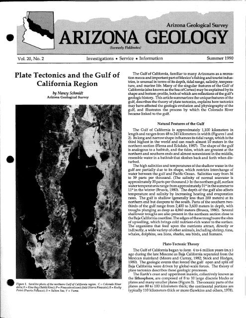
Figure 1. Satellite photo <strong>of</strong> <strong>the</strong> nor<strong>the</strong>rn <strong>Gulf</strong> <strong>of</strong> <strong>California</strong> region. C = Colorado River<br />
delta;K= Kino Bay (Bah{aKino); P =Pinacatevolcanic field (Sierra Pinacate);R =Rocky<br />
Point (Puerto Penasco); S = Salton Sea; Y = Yuma. .<br />
<strong>Plate</strong>-Tectonic <strong>The</strong>ory<br />
Th~ <strong>Gulf</strong> <strong>of</strong> <strong>California</strong> began to form 4 to 6 million yeats (m.y.)<br />
ago during <strong>the</strong> late Miocene as Baja <strong>California</strong> separated from <strong>the</strong><br />
Mexican mainl<strong>and</strong> (Moore <strong>and</strong> Curray, 1982; Stock <strong>and</strong> Hodges,<br />
1989). <strong>The</strong> geologic events that forced <strong>the</strong> gulf open <strong>and</strong> split <strong>of</strong>f<br />
Baja <strong>California</strong> were driven by global-scale forces. <strong>The</strong> <strong>the</strong>ory <strong>of</strong><br />
plate tectonics describes <strong>the</strong>se geologic processes.<br />
<strong>The</strong> Earth's crust <strong>and</strong> uppermost mantle, collectively known as<br />
<strong>the</strong> lithosphere, are composed <strong>of</strong> 8 to 10 large discrete blocks or<br />
plates <strong>and</strong> many smaller plates (Figure 3). <strong>The</strong> oceanic parts <strong>of</strong> <strong>the</strong><br />
plates are 80 to 100 kilometers thick; <strong>the</strong> continental portions are<br />
typically 110 kilometers thick or more (Sawkins <strong>and</strong> o<strong>the</strong>rs, 1978).
120"<br />
30'<br />
............<br />
100km<br />
110'<br />
Francisco '\<br />
120'<br />
\.<br />
\.<br />
CALIFORNIA \.<br />
\<br />
\<br />
\\<br />
NEVADA<br />
Antarctic plate<br />
40'<br />
30'<br />
Each plate moves with respect to <strong>the</strong> o<strong>the</strong>r<br />
plates. <strong>The</strong> boundaries between plates<br />
accommodate this motion <strong>and</strong> are <strong>the</strong> sites<br />
<strong>of</strong> several types <strong>of</strong> geologically important<br />
processes (Figure 4). Earthquakes, for example,<br />
are <strong>of</strong>ten associated with tectonic<br />
boundaries.<br />
<strong>Plate</strong>s maymove apart,leaving a gap (or<br />
rift) in between that fills with new molten<br />
crustal material. <strong>The</strong>newlyformed crustis<br />
hot relative to <strong>the</strong> crust surrounding it <strong>and</strong><br />
rises to form ridges (or rises; Figure 4A).<br />
Spreading occurs as<strong>the</strong> newcrust is added<br />
on ei<strong>the</strong>r side <strong>of</strong> <strong>the</strong> rift, being injected<br />
between older crust as <strong>the</strong> plates move<br />
apart. This process occurs in both oceanic<br />
<strong>and</strong> continental crust. Long continuous<br />
systems <strong>of</strong> troughs <strong>and</strong> ridges characterize<br />
spreading areas on oceanic plates. Spreading<br />
in continental settings breaks continents<br />
apart. <strong>The</strong> Great African Rift Valley<br />
in eastern Africa is an active example <strong>of</strong><br />
continental rifting.<br />
Driven by spreading forces, plates may<br />
movetoward one ano<strong>the</strong>r<strong>and</strong> collide. One<br />
plate may be pushed under ano<strong>the</strong>r or <strong>the</strong><br />
plates may slide past each o<strong>the</strong>r. Oceanic<br />
lithosphereis denser <strong>and</strong> heavierthan continentallithosphere,<br />
<strong>and</strong> consequently <strong>the</strong><br />
Figure 2 (left). Location <strong>of</strong><strong>the</strong> <strong>Gulf</strong> <strong>of</strong> <strong>California</strong>, Colorado<br />
River, Salton Sea, <strong>and</strong> San Andreas fault system,<br />
which includes several associated faults. Modified from<br />
Hamilton, 1961, p. 1309.<br />
Figure 3 (below). Major plates <strong>of</strong><strong>the</strong> world. <strong>The</strong> types <strong>of</strong><br />
plate boundaries, marked by heavy lines, rire as follows:<br />
(A) Midoceanic ridges at which <strong>the</strong> plates move apart are<br />
represented by double lines; (B) Transform fault boundaries<br />
are shown by single lines; <strong>and</strong> (C) Trenches <strong>and</strong><br />
o<strong>the</strong>r subduction zones are marked by lines with teeth<br />
on one side; <strong>the</strong> teeth point down <strong>the</strong> descending slab.<br />
Dashed lines are used where <strong>the</strong> exact location or nature<br />
<strong>of</strong><strong>the</strong> boundary is uncertain. From Sawkins <strong>and</strong> o<strong>the</strong>rs,<br />
1978, p.163.<br />
60"E<br />
oceanic plate is generally thrust (subducted><br />
beneath <strong>the</strong> continent (Figure 4B). <strong>Plate</strong><br />
destruction <strong>and</strong> plate formation balance<br />
each o<strong>the</strong>r, preserving <strong>the</strong> Earth's total surface<br />
area. <strong>Plate</strong>-tectonic <strong>the</strong>ory suggests that<br />
subduction is actively occurring at t<br />
boundaries <strong>of</strong>mostoceanic<strong>and</strong> continent<br />
plates in <strong>the</strong> Pacific Ocean. <strong>The</strong> Pacific<br />
<strong>Plate</strong>, for example, is being subducted<br />
underneathAsianearJapan;<strong>the</strong>associated<br />
melting <strong>of</strong> this oceanic crust formed <strong>the</strong><br />
Japaneseisl<strong>and</strong>s<strong>and</strong> accounts for <strong>the</strong>active<br />
volcanism inthis area. Collision <strong>of</strong><strong>the</strong>Eurasian<br />
<strong>and</strong> Indian <strong>Plate</strong>s, both continental<br />
plates, created <strong>the</strong> Himalaya Mountains as<br />
<strong>the</strong> plates collided <strong>and</strong> one overrode <strong>the</strong><br />
o<strong>the</strong>r. <strong>The</strong> resulting mountains are underlainbycrustthatis<br />
approximatelytwice <strong>the</strong><br />
average thickness <strong>of</strong> continental crust.<br />
<strong>Plate</strong>s may also move past one ano<strong>the</strong>r<br />
by shearing along faults that parallel <strong>the</strong><br />
plates' motion (Figure 4C). This type <strong>of</strong><br />
interaction along a transform boundary<br />
creates large stresses in <strong>the</strong> Earth's crust.<br />
<strong>The</strong> San Andreas fault represents <strong>the</strong> boundary<br />
between <strong>the</strong> Pacific <strong>and</strong> North American<br />
<strong>Plate</strong>s, which are moving past each<br />
o<strong>the</strong>r.<br />
<strong>Plate</strong>-tectonic <strong>the</strong>ory not only describes<br />
<strong>the</strong> relative motion between crustal plates<br />
today, but also provides a useful framework<br />
for reconstructing <strong>the</strong> positions <strong>of</strong><br />
plates in <strong>the</strong> past. For example, during <strong>the</strong><br />
late Paleozoic <strong>and</strong> early Mesozoic eras, approximately<br />
225 m.y. ago, all <strong>of</strong> <strong>the</strong> continents<br />
were assembled into one large continent,<br />
known as Pangaea. Evidence for t!lA<br />
e~dstence <strong>of</strong> Pangaea comes from man'"<br />
sources, including <strong>the</strong> distribution <strong>of</strong><br />
"matching" rocks <strong>and</strong> fossils <strong>of</strong> <strong>the</strong> same<br />
age on different continents, <strong>the</strong> shapes <strong>of</strong><br />
<strong>the</strong> continents, <strong>and</strong> paleomagnetic data.<br />
<strong>The</strong> Glossopteris flora, an assemblage<br />
<strong>of</strong> Permian (286- to 245<br />
m.y.-old) plant fossils, is present<br />
in Africa, Australia, India,<br />
Madagascar, South America,<br />
<strong>and</strong> Antarctica. Africa <strong>and</strong> South<br />
America fit toge<strong>the</strong>rlike pieces<br />
<strong>of</strong> a puzzle. <strong>The</strong>y formed a<br />
singlecontinent thatwas rifted<br />
apart <strong>and</strong> separated by seafloor<br />
spreading, which created<br />
60"N<br />
<strong>the</strong>Atlantic Ocean. Paleomagnetism,<br />
<strong>the</strong> relict magnetism<br />
within magnetic minerals in<br />
rocks, represents <strong>the</strong> state <strong>of</strong><br />
<strong>the</strong> Earth's magnetic field at<br />
<strong>the</strong> time <strong>the</strong> rock was formed.<br />
<strong>The</strong>direction <strong>of</strong><strong>the</strong> paleomagnetism<br />
maybe compared with<br />
<strong>the</strong>magneticfieldato<strong>the</strong>rlocations<br />
<strong>and</strong> o<strong>the</strong>r times. Paleomagnetic<br />
data, <strong>the</strong>refore, may<br />
serve as compass needles, allowing<br />
geologists to reconstruct<br />
<strong>the</strong> geographical distribution.<br />
<strong>and</strong> motions <strong>of</strong>oceans <strong>and</strong>COl.<br />
tinents during <strong>the</strong> past.<br />
<strong>The</strong> changing positions <strong>of</strong><br />
2 <strong>Arizona</strong> Geology, vol. 20, no. 2, Summer 1990
Figure 4. Three types <strong>of</strong> plate boundaries <strong>and</strong> relative<br />
plate motions. (A) Divergent (plates move away from<br />
each o<strong>the</strong>r): <strong>the</strong> process <strong>of</strong>sea-floor spreading creates new<br />
oceanic lithosphere; (B) Convergent (plates approach each<br />
o<strong>the</strong>r): <strong>the</strong> process <strong>of</strong>subduction destroys lithosphere; (C)<br />
Transform (plates slide past each o<strong>the</strong>r withoutapproachingordiverging):<br />
transform faulting is <strong>the</strong> corresponding<br />
.rocess. Modified from Sawkins <strong>and</strong> o<strong>the</strong>rs, 1978, p.165.<br />
crustal plates have affected many <strong>of</strong> <strong>the</strong><br />
Earth's systems. <strong>The</strong> positions <strong>of</strong> continents<br />
<strong>and</strong> oceans, for example, influence<br />
oceanic <strong>and</strong> atmospheric current patterns.<br />
<strong>The</strong>se, in turn, significantly affect global<br />
climate. <strong>Plate</strong> tectonics also plays a role in<br />
polar glaciation. Along with periodic, favorable<br />
climatic conditions, resulting from<br />
changes in<strong>the</strong> Earth's orbit, <strong>the</strong> presence<strong>of</strong><br />
a l<strong>and</strong> mass or continent near or over <strong>the</strong><br />
pole is necessary for polar glaciation. As<br />
polar ice accumulates, sea level drops worldwide<br />
<strong>and</strong> ice sheets spread over <strong>the</strong> continents.<br />
Tectonic History <strong>of</strong> <strong>the</strong> <strong>Gulf</strong><br />
Both <strong>the</strong> physical characteristics<strong>and</strong><strong>the</strong><br />
origin <strong>of</strong> <strong>the</strong> <strong>Gulf</strong> <strong>of</strong> <strong>California</strong> are intimately<br />
tied to tectonic processes. <strong>The</strong> gulf<br />
is bounded on <strong>the</strong> nor<strong>the</strong>ast by <strong>the</strong> North<br />
American <strong>Plate</strong>, which includes <strong>the</strong> North<br />
American continent, <strong>and</strong> on <strong>the</strong> southwest<br />
by <strong>the</strong> Pacific <strong>Plate</strong>, which is current!y moving<br />
northwest with respectto <strong>the</strong>NorthAmerican<br />
<strong>Plate</strong>. <strong>The</strong> San Andreas fault system is<br />
part <strong>of</strong> <strong>the</strong> boundary between <strong>the</strong>se two<br />
plates. <strong>The</strong> East Pacific Rise, a spreading<br />
system on <strong>the</strong> Pacific <strong>Plate</strong> near its boundary<br />
with <strong>the</strong> North American <strong>Plate</strong> (Figure<br />
A'3), has been partially subducted under<br />
~eath<strong>the</strong> North American <strong>Plate</strong> during<strong>the</strong><br />
past 30 m.y. (Atwater, 1970). In <strong>the</strong>vicinity<br />
<strong>of</strong><strong>the</strong>gulf, subductionoccurred on<strong>the</strong>west<br />
side<strong>of</strong>Baja <strong>California</strong>, which was <strong>the</strong>npart<br />
<strong>of</strong><strong>the</strong> Mexican mainl<strong>and</strong>. Subduction ceased,<br />
however, <strong>of</strong>f<strong>the</strong> Baja coast 10 m.y. ago, <strong>and</strong><br />
<strong>the</strong>juncturebetween<strong>the</strong>twoplatesbecame<br />
a transform boundary (Atwater, 1970; Figure<br />
4C). By 6 to 4 m.y. ago <strong>the</strong> margin<br />
streng<strong>the</strong>ned, probably as it cooled <strong>and</strong><br />
became more rigid, <strong>and</strong> a weaker inl<strong>and</strong><br />
zone broke to accommodate <strong>the</strong> shearing<br />
motion between <strong>the</strong> two plates (Atwater,<br />
1970). <strong>The</strong> shift <strong>of</strong> this plate margin had<br />
two important results: Baja <strong>California</strong> was<br />
ripped <strong>of</strong>f <strong>of</strong><strong>the</strong> North American <strong>Plate</strong> <strong>and</strong><br />
became part <strong>of</strong> <strong>the</strong> Pacific <strong>Plate</strong>, <strong>and</strong> <strong>the</strong><br />
<strong>Gulf</strong> <strong>of</strong> <strong>California</strong> was created (Atwater,<br />
1970). Both Baja <strong>California</strong> <strong>and</strong> a large<br />
portion <strong>of</strong>sou<strong>the</strong>rn <strong>California</strong> arenowpart<br />
<strong>of</strong> <strong>the</strong> Pacific <strong>Plate</strong>, which continues to move<br />
northwest withrespectto <strong>the</strong> NorthAmerican<br />
<strong>Plate</strong>. Baja <strong>California</strong>, infact, has moved<br />
approximately 300 kilometers to <strong>the</strong> northwest<br />
from its originalpositionon<strong>the</strong> North<br />
American <strong>Plate</strong> (Moore <strong>and</strong> Curray,1982).<br />
Reconstruction <strong>of</strong> <strong>the</strong> positions <strong>of</strong> Baja<br />
<strong>California</strong> <strong>and</strong> <strong>the</strong> Mexican mainl<strong>and</strong> reveals<br />
that a largeembayment existed in <strong>the</strong><br />
continent during <strong>the</strong> late Miocene (12 to 5<br />
m.y. ago), priorto <strong>the</strong> opening <strong>of</strong><strong>the</strong><strong>Gulf</strong><strong>of</strong><br />
<strong>California</strong>. Evidence for this embayment,<br />
known as <strong>the</strong> "proto-gulf," includes <strong>the</strong><br />
distribution <strong>of</strong>marine<strong>and</strong> nonmarine sedimentary<br />
rocks <strong>and</strong> changes in volcanic<br />
patterns that predate rifting (Stock <strong>and</strong><br />
Hodges, 1989). Several mechanisms have<br />
beeninvoked to explain<strong>the</strong>existence <strong>of</strong><strong>the</strong><br />
proto-gulf, including Basin <strong>and</strong> Range extension,<br />
which is related to <strong>the</strong> widespread<br />
mountain-forming episodethatoccurred in<br />
<strong>Arizona</strong> during this time, <strong>and</strong> extension<br />
associated withdevelopment <strong>of</strong><strong>the</strong> Pacific<br />
NorthAmerican<strong>Plate</strong>boundary (Stock <strong>and</strong><br />
Hodges, 1989). This extension may have<br />
weakened <strong>the</strong> crust underlying <strong>the</strong> protogulf<br />
<strong>and</strong> facilitated <strong>the</strong> onset <strong>of</strong>rifting (Stock<br />
<strong>and</strong> Hodges, 1989).<br />
Tect()nism<strong>and</strong> Sedimentation<br />
Patterns in <strong>the</strong> <strong>Gulf</strong><br />
<strong>The</strong> spreading centerin <strong>the</strong> <strong>Gulf</strong><strong>of</strong><strong>California</strong><br />
doesnotform a straightline<strong>of</strong>ridges<br />
<strong>and</strong> troughs because both spreading <strong>and</strong><br />
transform motion are occurring. This creates<br />
a zigzag pattern <strong>of</strong> troughs <strong>and</strong> faults<br />
(Figure 5). <strong>The</strong> floor <strong>of</strong> <strong>the</strong> gulf contains a<br />
series <strong>of</strong> parallel faults aligned with <strong>the</strong><br />
motion<strong>of</strong><strong>the</strong>Pacific<strong>Plate</strong><strong>and</strong> separatedby<br />
small deep troughs, which are <strong>the</strong> sites <strong>of</strong><br />
spreading <strong>and</strong> are approximately perpendicular<br />
to <strong>the</strong> faults.<br />
Estimated sedimentation rates within<br />
<strong>the</strong>gulf are high, especially in <strong>the</strong> nor<strong>the</strong>rn<br />
part. This area received large volumes <strong>of</strong><br />
sediment from <strong>the</strong> Colorado River before<br />
<strong>the</strong> 20th century. <strong>The</strong> thick cover <strong>of</strong> sediments<br />
that blankets <strong>the</strong> floor <strong>of</strong> <strong>the</strong> gulf<br />
obscures many <strong>of</strong> <strong>the</strong> features associated<br />
with both rifting <strong>and</strong> transform faulting;<br />
however, data from geophysical surveys<br />
<strong>and</strong> sea-floor drilling throughout <strong>the</strong> gulf<br />
have contributed to unraveling its history.<br />
In <strong>the</strong> Guaymas basin near <strong>the</strong> middle <strong>of</strong><br />
<strong>the</strong> gulf, for example, accumulation rates<br />
for <strong>the</strong> late Pleistocene <strong>and</strong> Holocene (2<br />
m.y. ago to <strong>the</strong> present) may exceed 2 meters<br />
per 1,000 years in some areas (Curray<br />
<strong>and</strong> o<strong>the</strong>rs, 1982). Bathymetry (<strong>the</strong> measurement<br />
<strong>of</strong> ocean depth <strong>and</strong> topography)<br />
<strong>and</strong>geophysical magnetic<strong>and</strong> seismicdata<br />
reveal <strong>the</strong> presence <strong>of</strong> three active transform<br />
faults separated bytwo narrow troughs<br />
in <strong>the</strong>Guaymas basin (Bisch<strong>of</strong>f <strong>and</strong> Henyey,<br />
1974). <strong>The</strong> troughs are sites <strong>of</strong> active spreading,<br />
where an estimated 5 to 6 centimeters<br />
<strong>of</strong> new crust are added each year (Larson<br />
<strong>and</strong> o<strong>the</strong>rs, 1972; Moore <strong>and</strong> Curray, 1982).<br />
KEY:<br />
ftranSform<br />
fault<br />
spreading<br />
center<br />
30°<br />
115°<br />
25°<br />
110"<br />
20"<br />
L......-....J<br />
100km<br />
Pacific<br />
Ocean<br />
Salton<br />
\ Sea<br />
115°<br />
25°<br />
Figure 5. Transform faults <strong>and</strong> spreading centers in <strong>the</strong><br />
<strong>Gulf</strong><strong>of</strong><strong>California</strong>. Note: Faults associated with <strong>the</strong> San<br />
Andreas fault system are shown in greater detail than in<br />
Figure 2. Modified from Moore, 1973, p. 1886.<br />
<strong>Arizona</strong> Geology, vol. 20, no. 2, Summer 1990 3
---Mix---~<br />
leo) Yuma<br />
o 20<br />
I<br />
kilometers<br />
I<br />
//' .......... J<br />
1 NI<br />
Figure 6. Distribution <strong>of</strong> <strong>the</strong> Bouse Formation. From<br />
Smith, 1970, p.141S.<br />
<strong>The</strong> Salton Trough <strong>and</strong> Colorado River<br />
At its nor<strong>the</strong>rn end, <strong>the</strong> <strong>Gulf</strong> <strong>of</strong> <strong>California</strong><br />
spreading system is linked with <strong>the</strong><br />
Salton Trough <strong>and</strong> <strong>the</strong> San Andreas fault<br />
system (Figure 5). <strong>The</strong> Salton Trough is a<br />
structural continuation <strong>of</strong> <strong>the</strong> <strong>Gulf</strong> <strong>of</strong> <strong>California</strong><br />
that has been cut <strong>of</strong>ffrom <strong>the</strong> gulfby<br />
sediments deposited by <strong>the</strong> Colorado River.<br />
Itineludes <strong>the</strong>Colorad0 River delta<strong>and</strong> <strong>the</strong><br />
Mexicali, Imperial, <strong>and</strong> Coachella Valleys.<br />
In some areas, <strong>the</strong> floor <strong>of</strong> <strong>the</strong> trough lies<br />
more than 402 meters below sea level (Brusca,<br />
1980). <strong>The</strong> nor<strong>the</strong>rn gulf <strong>and</strong> proto-gulf<br />
once extended into <strong>the</strong> trough, forming a<br />
large embayment at various times during<br />
<strong>the</strong> late Miocene <strong>and</strong> early Pliocene, approximately<br />
11 to 3 m.y. ago (Metzger,<br />
1968).<br />
Although geologists dispute when <strong>and</strong><br />
where <strong>the</strong> Colorado River began flowing<br />
into <strong>the</strong> gulf, evidence suggests that <strong>the</strong><br />
local drainage system that developed at<strong>the</strong><br />
nor<strong>the</strong>rn e!ld <strong>of</strong> <strong>the</strong> gulf eventually joined<br />
<strong>the</strong>Colorado River during <strong>the</strong> late Miocene<br />
to early Pliocene (5.5 m.y. ago; Lucchitta,<br />
1972, 1989). <strong>The</strong> absence <strong>of</strong> older deposits<br />
associated with a south-draining river system<br />
in southwestern <strong>Arizona</strong> <strong>and</strong> <strong>the</strong> presence<br />
<strong>of</strong> basin sediments deposited by interior<br />
drainagessupportthis scenario (Eberly<br />
<strong>and</strong> Stanley, 1978). <strong>The</strong> depositional condi-<br />
,<br />
-.'<br />
°Parker\... )<br />
if-<br />
, \<br />
M<br />
I<br />
'"<br />
'"<br />
II" /1 I<br />
\ I<br />
\j<br />
/ "I<br />
I -<br />
I<br />
\I<br />
~ ~ ~~ 300-meter contour<br />
.. Outcrops <strong>of</strong> Bouse<br />
Formation<br />
tions <strong>of</strong> <strong>the</strong> Bouse Formation, which consists<br />
<strong>of</strong> Miocene-Pliocene estuarine deposits<br />
exposed along <strong>the</strong> Colorado River from<br />
Yuma to north<strong>of</strong>Parker (Figure 6), become<br />
progressively less saltyto <strong>the</strong> north (Metzger,<br />
1968; Smith, 1970). This requires an<br />
influx <strong>of</strong> fresh water during deposition <strong>of</strong><br />
<strong>the</strong> Bouse Formation, which suggests that<br />
<strong>the</strong> ancestral Colorado River had begun to<br />
drain into <strong>the</strong> Bouse embayment <strong>and</strong>, ultimately,<br />
<strong>the</strong> <strong>Gulf</strong> <strong>of</strong> <strong>California</strong> (Lucchitta,<br />
1972,1989).<br />
<strong>The</strong> Colorado River progressivelyfilled<br />
<strong>the</strong> estuary with sediments until its delta<br />
reached <strong>the</strong> Salton Trough. <strong>The</strong> Imperial<br />
Formation (Miocene-Pliocene age) <strong>of</strong> <strong>the</strong><br />
Salton Trough area contains a well-defined<br />
horizon, above which are fossils in rocks<br />
that were derived from <strong>the</strong> Colorado <strong>Plate</strong>au.<br />
<strong>The</strong>se fossils record <strong>the</strong>integration <strong>of</strong><br />
<strong>the</strong> nor<strong>the</strong>rn Colorado River with <strong>the</strong> sou<strong>the</strong>rn<br />
drainages in <strong>the</strong> Salton Trough area<br />
(Lucchitta, 1972, 1989). <strong>The</strong> delta deposits<br />
<strong>of</strong> <strong>the</strong> Colorado River eventually extended<br />
<strong>the</strong> entirewidth <strong>of</strong><strong>the</strong> nor<strong>the</strong>rn gulf, isolating<strong>the</strong>Salton<br />
Trough from <strong>the</strong> gulf. (Without<strong>the</strong><br />
Colorado River delta, <strong>the</strong>gulftoday<br />
would extend northward to approximately<br />
PalmSprings.) <strong>The</strong>river alternated its flow<br />
between<strong>the</strong>isolated trough, which became<br />
a lake, <strong>and</strong> <strong>the</strong> nor<strong>the</strong>rn gulf, but currently<br />
flows onlyinto <strong>the</strong> gulf. <strong>The</strong> lake dried up<br />
<strong>and</strong> remained dry until 1905, when floods<br />
destroyed <strong>the</strong> headworks <strong>of</strong> an irrigation<br />
canal <strong>and</strong> diverted <strong>the</strong> Colorado River into<br />
<strong>the</strong> fertile Imperial Valley. For 2 years, <strong>the</strong><br />
entire river flowed down <strong>the</strong> canal <strong>and</strong><br />
emptied into <strong>the</strong> trough. <strong>The</strong> canal was<br />
repaired in 1907, leaving behind <strong>the</strong> nooutlet<br />
Salton Sea (Reisner, 1986).<br />
Human activities have also affected <strong>the</strong><br />
Colorado River delta <strong>and</strong> <strong>the</strong> <strong>Gulf</strong> <strong>of</strong> <strong>California</strong>.<br />
Before <strong>the</strong> 20th century, sediments<br />
carried by <strong>the</strong> river made <strong>the</strong>ir way as far<br />
south as La Paz, approximately 1,000 kilometers<br />
from <strong>the</strong> river's mouth. With <strong>the</strong><br />
construction <strong>of</strong> ir- rigation projects in<br />
<strong>the</strong> Imperial Valley <strong>and</strong> dams<br />
along <strong>the</strong> Colorado River,<br />
river flow into <strong>the</strong><br />
gulf has<br />
been reduced<br />
to<br />
almost<br />
z e r 0<br />
(Brusca,<br />
1980).<br />
<strong>The</strong><br />
a vera ge<br />
annual<br />
flow from<br />
1902 to<br />
1934 was m 0 r e<br />
than 15 mil-<br />
lion acrefeet,<br />
as mea-<br />
sured near<br />
Yuma. From<br />
1935to1964,<br />
<strong>the</strong> annual dis-<br />
charge <strong>of</strong> river<br />
water into <strong>the</strong><br />
gulfdecreased<br />
to slightly more than 4 million<br />
acre-feet, <strong>and</strong> by <strong>the</strong> late 1960's only subsurface<br />
percolation <strong>and</strong> diverted flows<br />
reached <strong>the</strong>gulf. ColoradoRiver waterthat<br />
does flow into <strong>the</strong> gulf is typically very saline<br />
<strong>and</strong> polluted by pesticides <strong>and</strong> fertilizers<br />
(Brusca, 1980). Both sedimentation <strong>and</strong><br />
input <strong>of</strong> fresh water, th~refore, have been<br />
dramatically decreased by human activities.<br />
In <strong>the</strong> future, <strong>the</strong> geologic history <strong>of</strong><br />
<strong>the</strong> <strong>Gulf</strong> <strong>of</strong> <strong>California</strong> will be affected not<br />
only by natural processes but also by human<br />
intervention.<br />
References<br />
Atwater, Tanya, 1970, Implications <strong>of</strong>plate tectonics<br />
for <strong>the</strong> Cenozoic tectonic evolution <strong>of</strong> western<br />
North America: Geological Society <strong>of</strong> America<br />
Bulletin, v. 81, p. 3513-3536.<br />
Bisch<strong>of</strong>f, J.L., <strong>and</strong> Henyey, T.L., 1974, Tectonic elements<br />
<strong>of</strong> <strong>the</strong> centralpart<strong>of</strong> <strong>the</strong><strong>Gulf</strong><strong>of</strong><strong>California</strong>:<br />
Geological Society <strong>of</strong> America Bulletin, v. 85, p.<br />
1893-1904.<br />
Brusca, RC, 1980, Common intertidal invertebrates<br />
<strong>of</strong> <strong>the</strong> <strong>Gulf</strong> <strong>of</strong> <strong>California</strong>: Tucson, University <strong>of</strong><br />
<strong>Arizona</strong> Press, 513 p.<br />
Curray, J.R, Moore, D.G., Aguaryo, J.E., Aubry,<br />
M.P., Einsele, G., Fornari, D., Gieskes, J., Guerrero-Garcia,<br />
J., Kastner, M., Kelts, K., Lyle, M.,<br />
Matoba, Y., Molina-Cruz, A., Niemitz, J., Saunders,<br />
A., Schrader,H., Simonett, B.RT., <strong>and</strong> Vacquier,V.,<br />
1982,Guaymasbasin: Sites 477,478, <strong>and</strong><br />
481, in Curray,J.R, <strong>and</strong> Moore, D.G., eds., Initial<br />
reports <strong>of</strong> <strong>the</strong> Deep Sea Drilling Project: Washington,D.C,U.S.<br />
GovernmentPrintingOffice, v.<br />
64, pt. 1, p. 211-415.<br />
Eberly, 1.D., <strong>and</strong> Stanley, T.B., Jr., 1978, Cenozoic<br />
stratigraphy <strong>and</strong> geologie history <strong>of</strong> southwestern<br />
<strong>Arizona</strong>: Geological Society <strong>of</strong> America<br />
Bulletin, v. 89, p. 921-940.<br />
Flessa, K.W., <strong>and</strong> Eckdale, A.A., 1987, Paleoecology<br />
<strong>and</strong> taphonomy <strong>of</strong> Recent to Pleistocene intertidal<br />
deposits, <strong>Gulf</strong><strong>of</strong><strong>California</strong>, in Flessa,K.W.,<br />
ed., Paleoecology <strong>and</strong> taphonomy <strong>of</strong> Recent to<br />
Pleistocene intertidal deposits, <strong>Gulf</strong> <strong>of</strong> <strong>California</strong>:<br />
Paleontological Society Special Publication<br />
no. 2, p. 2-33.<br />
Hamilton, Warren, 1961, Origin <strong>of</strong> <strong>the</strong> <strong>Gulf</strong> <strong>of</strong> <strong>California</strong>:<br />
Geological Society<strong>of</strong>America Bulletin, v.<br />
72, p. 1307-1318.<br />
Larson, P.A., Mudie, J.D., <strong>and</strong> Larson, RL., 1972_,".<br />
Magnetic anomalies <strong>and</strong> fracture-zone trends i ,<br />
<strong>the</strong> <strong>Gulf</strong> <strong>of</strong> <strong>California</strong>: Geological Society 0 . i<br />
America Bulletin, v. 83, p. 3361-3368.<br />
Lucchitta, Ivo, 1972, Early history <strong>of</strong> <strong>the</strong> Colorado<br />
Riverin <strong>the</strong> Basin <strong>and</strong> Range Province: Geological<br />
Society <strong>of</strong> America Bulletin, v. 83, p. 1933<br />
1948.<br />
__1989, History <strong>of</strong> <strong>the</strong> Gr<strong>and</strong> Canyon <strong>and</strong> <strong>of</strong> <strong>the</strong><br />
Colorado River in <strong>Arizona</strong>, in Jenney, J.P., <strong>and</strong><br />
Reynolds, S.J., eds., Geologic evolution <strong>of</strong> <strong>Arizona</strong>:<br />
<strong>Arizona</strong> Geological Society Digest 17, p.<br />
701-715.<br />
Metzger, D.G., 1968,<strong>The</strong> Bouse Formation (Pliocene)<br />
<strong>of</strong> <strong>the</strong> Parker-Bly<strong>the</strong>-Cibola area, <strong>Arizona</strong> <strong>and</strong><br />
<strong>California</strong>, in Geological Survey research 1968:<br />
U.S. Geological SurveyPr<strong>of</strong>essional Paper600-D,<br />
p.126-136.<br />
Moore, D.G., 1973, <strong>Plate</strong>-edge deformation <strong>and</strong><br />
crustal growth, <strong>Gulf</strong> <strong>of</strong> <strong>California</strong> structural<br />
province: Geological Society <strong>of</strong> America Bulletin,<br />
v. 84, p. 1883-1906.<br />
Moore, D.G., <strong>and</strong> Curray, RJ., 1982, Geologic <strong>and</strong><br />
tectonic history <strong>of</strong> <strong>the</strong> <strong>Gulf</strong> <strong>of</strong> <strong>California</strong>, in<br />
Curray, J.R, <strong>and</strong> Moore, D.G., eds., Initial reports<br />
<strong>of</strong> <strong>the</strong> Deep Sea Drilling Project: Washington,<br />
D.C., U.S. GovernmentPrinting Office, v. 64,<br />
pt. 1, p. 1279-1294.<br />
Reisner, Marc, 1986, Cadillac desert; <strong>the</strong> American<br />
West <strong>and</strong> its disappearing water: New York,<br />
Viking Penguin Inc., 582 p.<br />
Sawkins, F.J., Chase, CG., Darby, D.G., <strong>and</strong> Rapp,<br />
George, Jr., 1978, <strong>The</strong> evolving Earth: A text in<br />
physical geology: N ewYork, Macmillan Publishing<br />
Co., 558 p.<br />
Smith, P.R, 1970, New evidence for Pliocene marine<br />
embaymentalong <strong>the</strong>lowerColorado River area,<br />
<strong>California</strong> <strong>and</strong> <strong>Arizona</strong>: Geological Society <strong>of</strong><br />
America Bulletin, v. 81, p. 1411-1420.<br />
Stock, J.M., <strong>and</strong> Hodges, K.V., 1989, Pre-Pliocena,<br />
extension around <strong>the</strong> <strong>Gulf</strong> <strong>of</strong> <strong>California</strong> <strong>and</strong>th.'<br />
transfer <strong>of</strong> Baja <strong>California</strong> to <strong>the</strong> Pacific <strong>Plate</strong>: •<br />
<strong>Tectonics</strong>, v. 8, p. 99-115.<br />
<strong>Arizona</strong> Geology, vol. 20, no. 2, Summer 1990
<strong>The</strong> Nonfuel Mineral Industry: 1989 Summary,<br />
With Focus on <strong>the</strong> Southwest<br />
by Michael N. Greeley<br />
u.s. Bureau <strong>of</strong> Mines<br />
In 1989, <strong>the</strong> value <strong>of</strong> nonfuel mineral<br />
production continued to rise in <strong>the</strong> Southwest.<br />
Preliminary figures show that <strong>the</strong><br />
total value <strong>of</strong> production in this region<br />
exceeded one-third <strong>of</strong> <strong>the</strong> total production<br />
in<strong>the</strong> United States. Mines in<strong>the</strong> six southwestern<br />
states <strong>of</strong> <strong>Arizona</strong>, <strong>California</strong>, Colorado,<br />
Nevada, New Mexico, <strong>and</strong> Utah produced<br />
almost $ll-billion worth <strong>of</strong> mineral<br />
products, compared to<strong>the</strong>national production<br />
total <strong>of</strong> $32 billion (Figure 1; Table 1).<br />
Measured in dollars, <strong>the</strong> mineral output<br />
in <strong>the</strong> Southwest increased more than 10<br />
percent over that <strong>of</strong> 1988. Mineral producers<br />
in <strong>Arizona</strong> accounted for more than 10<br />
percent <strong>of</strong> U.S. nonfuel mineral wealth in<br />
1989, <strong>the</strong> largest State share <strong>of</strong> production<br />
in <strong>the</strong>Nation, followed closelybyoutput in<br />
,.(>.. <strong>Arizona</strong><br />
, A '3,190<br />
<strong>California</strong><br />
<strong>and</strong> Nevada (Figure 2).<br />
<strong>The</strong>se preliminary statistics were published<br />
by <strong>the</strong> U.S. Bureau <strong>of</strong> Mines (BOM),<br />
which has released State-by-State estimates<br />
<strong>of</strong> nonfuel mineral production for 1989.<br />
<strong>The</strong>se estimates, generally based on 9 months<br />
<strong>of</strong> data, have been published in one volume:<br />
State Mineral Summaries--1990. This<br />
_volume is designed to be a companion re<br />
~ort to ano<strong>the</strong>r BOM publication, Mineral<br />
Commodity Summaries-1990, which contains<br />
national statistics on 82 nonfuel minerals.<br />
Excerpts from bothvolumes appear below.<br />
Single copies <strong>of</strong> each are free from <strong>the</strong><br />
Publications Distribution Section, U.s. Bureau<br />
<strong>of</strong>Mines, Cochrans Mill Rd., P.O. Box<br />
18070,Pittsburgh,PA15236. Finalproduction<br />
figures for 1989 are expected to be<br />
available in August.<br />
<strong>The</strong> State summaries were prepared by<br />
State mineral <strong>of</strong>ficers from <strong>the</strong> BOM, in<br />
cooperation with <strong>the</strong> respective State mineral<br />
agencies. Individual summaries are<br />
also published separately as State Mineral<br />
Industry Surveys. Copies are available<br />
from <strong>the</strong> respective State mineral <strong>of</strong>ficers:<br />
FredV. Carrillo,1605 EvansAve., Reno, NV<br />
89512 (<strong>California</strong> <strong>and</strong> Nevada); Michael N.<br />
Greeley, 201 E. 7th St., Tucson, AZ 85705<br />
(<strong>Arizona</strong>, NewMexico, <strong>and</strong>Utah); <strong>and</strong>Jane<br />
P. Ohl, Bldg. 20, Denver Federal Center,<br />
Denver, CO 80225 (Colorado).<br />
1989 Value <strong>of</strong> Nonfuel<br />
Mineral Production,<br />
Southwest <strong>Region</strong><br />
(Millions <strong>of</strong> Dollars)<br />
U.S. SUMMARY<br />
<strong>The</strong>estimatedvalue<strong>of</strong>nonfuelmineral<br />
production in <strong>the</strong> United States increased<br />
about 6 percent in 1989 over that <strong>of</strong> <strong>the</strong><br />
previous year. Metal production, representing<br />
about 37 percent <strong>of</strong> <strong>the</strong> total value,<br />
rose 14 percent from $10.2 billion in1988 to<br />
$11.6 billion in 1989. Although <strong>the</strong> value <strong>of</strong><br />
industrial minerals, at $202 billion, accounted<br />
for 63 percent <strong>of</strong><strong>the</strong> 1989 total, <strong>the</strong> increase<br />
over that <strong>of</strong> 1988 was less than 2 percent.<br />
Limited supply <strong>and</strong> low inventories<br />
maintained <strong>the</strong> copper price above $1 per<br />
pound, <strong>and</strong> U.S. copper-mine production<br />
increased about 5 percent during 1989. In<br />
Februaryanagreement was reached on <strong>the</strong><br />
terms for an International Copper Study<br />
Group, which was conceived more than 2<br />
years ago by <strong>the</strong> United States.<br />
Domestic gold mines continued to produce<br />
at record levels during 1989; activity<br />
was centered in Nevada, <strong>California</strong>, <strong>and</strong><br />
Montana. Gold exploration declined slightly<br />
from <strong>the</strong> previous year, but continued to<br />
outpaceexploration for o<strong>the</strong>r commodities,<br />
both domestically <strong>and</strong> internationally.<br />
Weakening prices throughout <strong>the</strong> year<br />
apparently reflected an easing <strong>of</strong> world<br />
political tensions <strong>and</strong> expectation <strong>of</strong> increasing<br />
inflation. Gold price declines also<br />
contributed to <strong>the</strong>closure <strong>of</strong>marginalgoldmining<br />
operations.<br />
Domestic silver production increased for<br />
<strong>the</strong>thirdconsecutive year,despitea drop in<br />
<strong>the</strong> average silver price, because <strong>of</strong> <strong>the</strong><br />
opening <strong>of</strong> several new mines that recover<br />
silver as a byproduct. Notable among <strong>the</strong><br />
new mines is Greens Creek, a large zincsilver-lead<br />
mine in Alaska, which at full<br />
capacity is expected to be one <strong>of</strong> <strong>the</strong> largest<br />
domestic silver-producing mines. As in<br />
recent years, most <strong>of</strong> <strong>the</strong> new mines that<br />
opened in 1989 aregold mines where heap<br />
leaching is used to recover precious metals<br />
from low-grade ores.<br />
A continuing, tight supply-dem<strong>and</strong> situation<br />
resulted in record-high zinc prices<br />
<strong>and</strong> <strong>the</strong> opening <strong>of</strong> six zinc-producing mines<br />
in <strong>the</strong> United States. Domestic mine production<br />
rose for <strong>the</strong> third straight year;<br />
domestic smelters operated near capacity<br />
in 1989, producing <strong>the</strong> most metal since<br />
1981. U.S. production could double in 1990,<br />
largely because <strong>of</strong> rising output at <strong>the</strong> Red<br />
Dog mine in Alaska.<br />
World dem<strong>and</strong> for lead, at about 6 million<br />
metric tons, was a record high. This<br />
resulted in <strong>the</strong> highest average price on <strong>the</strong><br />
London Metal Exchange since 1981 <strong>and</strong> <strong>the</strong><br />
highest average domestic price since 1980.<br />
Production increased considerablybecause<br />
<strong>of</strong>newzinc-silver-lead mines inAlaska<strong>and</strong><br />
Montana <strong>and</strong> a reopened mine in Idaho.<br />
Much <strong>of</strong> this production was exported because<br />
<strong>of</strong> limited smelter capacity. <strong>The</strong> United<br />
States was expected to become a major exporter<strong>of</strong>lead<br />
concentrates, slarting in 1990.<br />
Strong overall dem<strong>and</strong> diminished excess<br />
inventories <strong>of</strong> molybdenum <strong>and</strong> production<br />
increased, compared with that <strong>of</strong><br />
1988. Althoughsteel dem<strong>and</strong> for molybdenum<br />
weakened slightly, prices were stable<br />
because <strong>the</strong> market remained in balance.<br />
One domestic producer reopened its primary<br />
molybdenum mine in Questa, New<br />
Mexico.<br />
<strong>Arizona</strong> Geology, vol. 20, no. 2, Summer 1990<br />
5
U.S. dem<strong>and</strong> for building <strong>and</strong> construction<br />
materials, such as construction aggregate,<br />
gypsum, <strong>and</strong> cement, remained strong<br />
in 1989. Cement imports declined slightly,<br />
representing about 17 percent <strong>of</strong> apparent<br />
consumption compared with 19 percent in<br />
1988. Mexico, supplying 29 percent <strong>of</strong> <strong>the</strong><br />
total, was <strong>the</strong> primary source <strong>of</strong> imports,<br />
followed by Canada, Japan, Spain, <strong>and</strong><br />
Greece. Mexico was also <strong>the</strong> target <strong>of</strong> an<br />
antidumpingpetition,filed byproducersin<br />
<strong>Arizona</strong>, Florida, New Mexico, <strong>and</strong> Texas,<br />
who alleged that Mexican cement was being<br />
sold in <strong>the</strong>se areas at less than fair value.<br />
This was <strong>the</strong> second petition filed against<br />
Mexico in<strong>the</strong>last3 years. <strong>The</strong>International<br />
Trade Commission made a preliminary<br />
determination that <strong>the</strong> cement industry in<br />
<strong>the</strong>se regions was materially injured by<br />
Mexican imports.<br />
U.S. dem<strong>and</strong> for construction aggregate<br />
improved for <strong>the</strong> fourth consecutive year<br />
<strong>and</strong> was at a near-record level. <strong>The</strong> U.S.<br />
gypsum industry performed well, even<br />
though new housing starts decreased for<br />
<strong>the</strong> third year in a row. Increased U.S. exports<br />
<strong>of</strong>gypsumwallboard <strong>and</strong> strength in<br />
<strong>the</strong> remodeling markets <strong>of</strong>fset<strong>the</strong> impact<strong>of</strong><br />
declining housing starts.<br />
Potash producer's stocks, which had been<br />
built up during <strong>the</strong> winter <strong>of</strong> 1988-89 in<br />
anticipation <strong>of</strong> a strong spring dem<strong>and</strong>,<br />
finished <strong>the</strong> year slightly down because <strong>of</strong><br />
a strongfall dem<strong>and</strong> <strong>and</strong>extended maintenance<br />
shutdowns at mines that restricted<br />
output. At <strong>the</strong> beginning <strong>of</strong> <strong>the</strong> year, <strong>the</strong><br />
Utah sulfate <strong>of</strong> potash facility, which was<br />
flooded by <strong>the</strong> Great Salt Lake in 1984,<br />
started operations with salts harvested from<br />
<strong>the</strong> ponds during <strong>the</strong> fall <strong>of</strong> 1988.<br />
<strong>The</strong> U.S. salt industry was <strong>the</strong> largest<br />
producer <strong>of</strong> salt in <strong>the</strong> world. Although<br />
output was relatively unchanged compared<br />
withthat <strong>of</strong><strong>the</strong> previous year, <strong>the</strong> structure<br />
<strong>of</strong><strong>the</strong> industry changed with mergers <strong>and</strong><br />
acquisitions.<br />
STATE SUMMARIES<br />
<strong>Arizona</strong><br />
<strong>Arizona</strong> mines led <strong>the</strong> Nation during<br />
1989 in<strong>the</strong> production <strong>of</strong>nonfuel minerals.<br />
Preliminaryfigures indicate that <strong>the</strong> value<br />
<strong>of</strong> output in <strong>the</strong> State totaled about $3.2<br />
billion,anincrease<strong>of</strong>IS percentoverthat <strong>of</strong><br />
1988 (Table 2). Supporting <strong>the</strong> first-place<br />
positionwas <strong>the</strong> high value ($2.9 billion) <strong>of</strong><br />
metallic minerals mined in <strong>Arizona</strong>. This<br />
amount rE;!presented a quarter <strong>of</strong> <strong>the</strong> value<br />
<strong>of</strong>all metals produced in<strong>the</strong> United States.<br />
Copper <strong>and</strong> molybdenum production was<br />
<strong>the</strong> highest <strong>of</strong> any State. <strong>Arizona</strong> was also<br />
among<strong>the</strong> leading States in<strong>the</strong> production<br />
<strong>of</strong>bentonite, cement, gem stones,lime, construction<br />
s<strong>and</strong> <strong>and</strong> gravel, <strong>and</strong> silver. <strong>The</strong><br />
State'srank indomestic production <strong>of</strong>gold,<br />
however, dropped from 8th to 10th place.<br />
<strong>Arizona</strong> mines produced approximately<br />
60 percent <strong>of</strong> <strong>the</strong> Nation's copper in 1989.<br />
Production reflected a S-percent increase<br />
over <strong>the</strong> 1988 level, with a IS-percent increase<br />
invalue. <strong>The</strong> producer copper price<br />
rosefrom a 1988 average<strong>of</strong>$1.21 perpound<br />
to $1.31 in 1989. In general, major copper<br />
producers in <strong>the</strong> State focused <strong>the</strong>ir attention<br />
on exp<strong>and</strong>ing present operations <strong>and</strong><br />
increasing <strong>the</strong> percentage <strong>of</strong> production<br />
achieved through <strong>the</strong> solvent extractionelectrowinning<br />
(SX-EW) process. Some<br />
companies produced more than 2S percent<br />
<strong>of</strong> <strong>the</strong>ir copper in SX-EW plants.<br />
A coalition <strong>of</strong> public <strong>and</strong> private interests<br />
continued an in-situ, copper-mining<br />
research project near Casa Gr<strong>and</strong>ein Pinal<br />
County. <strong>The</strong> site was drilled to obtain<br />
mineralized samples <strong>and</strong> fracture-orientation<br />
data from <strong>the</strong> buried Santa Cruz oxide<br />
copper deposit. By yearend, five deep drill<br />
holes were completed. Plans were madeto<br />
equip<strong>the</strong>seholesfor injection <strong>and</strong>recovery<br />
<strong>of</strong> solutions <strong>and</strong> to test <strong>the</strong> deposit for permeability<br />
characteristics.<br />
Gold productiondecreased 37 percentin<br />
19~9. <strong>The</strong> decrease was primarily due to a<br />
drop in gold prices <strong>and</strong> to a cessation or<br />
reduction <strong>of</strong> mining operations at several<br />
gold properties in<strong>the</strong> State. Silver production,<br />
which remained constant, was chiefly<br />
recovered from copper ores or smelter flux<br />
ores. <strong>Arizona</strong> mines continued to increase<br />
<strong>the</strong>iroutput<strong>of</strong>molybdenum. Productionin<br />
1989 was nearlyhalf<strong>of</strong><strong>the</strong> Nation's domestic<br />
supply.<br />
Exploration in <strong>Arizona</strong> continued to be<br />
concentrated on <strong>the</strong> search for precious<br />
TabId. Value <strong>of</strong>nonfuel mineral production in <strong>the</strong> Southwest, measured by mine shipments, sales, or marketable production,<br />
including consumption by producers. Allfigures are from <strong>the</strong> U.S. Bureau <strong>of</strong>Mines; totals for 1989 are preliminary<br />
estimates.<br />
Value (thous<strong>and</strong>s Percent <strong>of</strong> Total<br />
State <strong>of</strong> dollars) Value in 1989 Principal Minerals<br />
1988 1989 Southwest U.S.<br />
<strong>Arizona</strong> 2,773,411 3,190,266 29.3 10.0 copper, molybdenum, s<strong>and</strong> & gravel<br />
<strong>California</strong> 2,708,768 2,839,141 26.1 8.9 s<strong>and</strong> & gravel, cement, boron<br />
Colorado 364,005 442,911 4.1 1.4 molybdenum, s<strong>and</strong> & gravel, cement<br />
Nevada 1,944,566 1,996,062 18.4 6.3 gold, silver, s<strong>and</strong> & gravel<br />
New Mexico 1,022,672 1,164,882 10.7 3.7 copper, potash, s<strong>and</strong> & gravel<br />
Utah 1,014,847- 1,241,484 11.4 3.9 copper, gold, magnesium metal<br />
SOUTHWEST 9,828,269 10,874,746 100.0 34.2<br />
U.S. TOTAL 30,021,452 31,810,960 100.0<br />
Figure 2. T S Ary (center), Director <strong>of</strong> <strong>the</strong> U.S. Bureau<br />
<strong>of</strong>Mines (BaM), recently visited <strong>the</strong> <strong>Arizona</strong> Geological<br />
Survey to discuss nonfuel mineral production <strong>and</strong> metallic<br />
mineral districts in <strong>Arizona</strong>. With him are Michael N.<br />
Greeley (right), BaM State Mineral Officer for <strong>Arizona</strong>,<br />
New Mexico, <strong>and</strong> Utah, <strong>and</strong> Larry D. Fellows (left),<br />
Director <strong>of</strong> <strong>the</strong> Aritona Geological Survey.<br />
Tab/e2. Value <strong>of</strong>nonfuel mineral production in <strong>Arizona</strong>,<br />
measured by mine shipments, sales, or marketable production,<br />
including consumption by producers. All figures<br />
arefrom <strong>the</strong> U.S. Bureau <strong>of</strong>Mines; totals for 1989 are<br />
preliminary estimates.<br />
Mineral<br />
Value (thous<strong>and</strong>s <strong>of</strong> dollars)<br />
1988 1989<br />
Clays 1,590 2,010<br />
Copper 2,246,093 2,592,723<br />
Diatomite 1,208 1,208<br />
Gem stones 3,300 3,300<br />
Gold 64,106 35,264<br />
Lime 29,637 W<br />
S<strong>and</strong> <strong>and</strong> gravel<br />
Construction 123,854 133,500<br />
Industrial 3,045 W<br />
Silver 31,974 27,236<br />
Stone<br />
Crushed 33,000' 26,200<br />
Dimension I' 1<br />
O<strong>the</strong>r" 235,596 368,824<br />
TOTAL 2,773,411 3,190,266<br />
W Withheld to avoid disclosing company proprietarydata;<br />
value included in "O<strong>the</strong>r"figure.<br />
, Estimated.<br />
" Combined value <strong>of</strong> cement, lead (1988), molybdenum,<br />
perlite (1988-89), pyrites, salt, tin<br />
(1988-89), <strong>and</strong> values indicated by symbol W.<br />
metals <strong>and</strong> low-costleachablecopper. Gold<br />
discoveries wereannouncedat<strong>the</strong>Mexican<br />
Hat property in Cochise County <strong>and</strong> near<br />
Yarnell in Yavapai County. Although no<br />
new deposits <strong>of</strong> leachable copper were reported<br />
during 1989, several properties, including<strong>the</strong><br />
Cochise in Cochise County<strong>and</strong><br />
Sanchez in Graham County, were extensivelyevaluated<br />
for possible development.<br />
<strong>The</strong> value <strong>of</strong>industrial mineral production<br />
was about $290 million. <strong>Arizona</strong> ranked<br />
sixth in <strong>the</strong> Nation in production <strong>of</strong> construction<br />
s<strong>and</strong> <strong>and</strong> gravel,which remained<br />
<strong>the</strong> largest component <strong>of</strong> <strong>the</strong> State's industrial<br />
mineral output. Cement, lime, <strong>and</strong><br />
crushed stonewerealso majorcontributors.<br />
In addition, <strong>Arizona</strong> mines held <strong>the</strong>ir position<br />
nationally among <strong>the</strong> leading produc.l j<br />
ers <strong>of</strong> bentonite <strong>and</strong> naturally occurrin Jb<br />
gem stones.<br />
6 <strong>Arizona</strong> Geology, vol. 20, no. 2, Summer 1990
<strong>The</strong> U.S. Supreme Court issued a ruling<br />
inMayina case involvingroyalties paidby<br />
mining companies for minerals extracted<br />
from State trust l<strong>and</strong>s. <strong>The</strong> Court said<br />
e<br />
<strong>Arizona</strong> must establisha method <strong>of</strong>assessing<br />
<strong>the</strong> "true·value" <strong>of</strong> <strong>the</strong> rninerals re-<br />
moved. <strong>The</strong> State will now require mining<br />
companies to pay a minimum royalty <strong>of</strong> 2<br />
percent <strong>of</strong> <strong>the</strong> gross value <strong>of</strong> <strong>the</strong> mineral<br />
removed from trust l<strong>and</strong>s, with possible<br />
increases in <strong>the</strong> future.<br />
<strong>California</strong><br />
<strong>California</strong> was <strong>the</strong> second leading State<br />
in <strong>the</strong> Nation in <strong>the</strong> production <strong>of</strong> nonfuel<br />
minerals during 1989. <strong>The</strong> value <strong>of</strong> commodities<br />
produced wasestimatedto be$2.8<br />
billion, a 5-percent increase over that <strong>of</strong><br />
1988. <strong>California</strong>led allStatesin<strong>the</strong> production<br />
<strong>of</strong> asbestos, boron minerals, portl<strong>and</strong><br />
cement, diatomite, calcined gypsum, rareearth<br />
concentrates, construction s<strong>and</strong> <strong>and</strong><br />
gravel, <strong>and</strong> tungsten. It was second in <strong>the</strong><br />
production <strong>of</strong> natural calcium chloride, feldspar,gold,byproductgypsum,magnesium<br />
compounds from seawater <strong>and</strong> brines, <strong>and</strong><br />
sodium compounds.<br />
Gold exploration in <strong>California</strong> continued,<br />
although at a slower pace than <strong>the</strong><br />
previous year as lower prices <strong>and</strong> new<br />
regulations dampened enthusiasm for<br />
precious-metal exploration. Nearby residents,<br />
environmentalists, <strong>and</strong> no-growth<br />
proponents continued to impede mining<br />
operations throughout <strong>the</strong> State as <strong>the</strong>y<br />
_ opposed <strong>the</strong> issue <strong>of</strong> new mining permits<br />
• by local governments to s<strong>and</strong>-<strong>and</strong>-gravel<br />
quarries <strong>and</strong> gold-miningfacilities. Operations<br />
were shut down at several gold mines<br />
during <strong>the</strong> year.<br />
Newgold-mining operations, however,<br />
at <strong>the</strong> American Girl Canyon project were<br />
approved <strong>and</strong> construction began early in<br />
<strong>the</strong>year at<strong>the</strong> mine in Imperial County. In<br />
March production began at <strong>the</strong> Royal<br />
Mountain King gold mine in Calaveras<br />
County <strong>and</strong> development was initiated at<br />
<strong>the</strong> Hayden Hill mine in Lassen County.<br />
One cement company <strong>and</strong> <strong>the</strong> Port <strong>of</strong><br />
Richmond discussed <strong>the</strong> possible development<br />
<strong>of</strong> an $11-million bulk-cement distribution<br />
facility north <strong>of</strong> <strong>the</strong> Port's container<br />
terminal. <strong>The</strong> facility would use a highcapacity<br />
pneumatic unloading system <strong>and</strong><br />
an underground piping networktoremove<br />
cement from incoming ships <strong>and</strong> transport<br />
it to silos to await loading onto o<strong>the</strong>r ships<br />
<strong>and</strong> railcars.<br />
<strong>The</strong> State <strong>Region</strong>al Water Quality Control<br />
Board became <strong>the</strong> sole regulator <strong>of</strong><br />
mining wastes after passage <strong>of</strong> Assembly<br />
Bill 1413 in November. <strong>The</strong> bill reflected<br />
recommendations <strong>of</strong>a mining-waste study<br />
that<strong>the</strong>University<strong>of</strong><strong>California</strong> atBerkeley<br />
conducted. This study endorsed eliminating<br />
dual permits <strong>and</strong> shifting regulatory<br />
._ authority for mining-waste matterS from<br />
.., <strong>the</strong> Department <strong>of</strong> Health Services to <strong>the</strong><br />
Water Board.<br />
Colorado<br />
<strong>The</strong> estimated value<strong>of</strong>nonfuelminerals<br />
produced in Colorado in 1989 was $443<br />
million, compared with $364 million in1988.<br />
This 22-percent risewas mainlyduetounitprice<br />
increases for molybdenum, construction<br />
s<strong>and</strong> <strong>and</strong> gravel, <strong>and</strong> zinc <strong>and</strong> a substantial<br />
production increase for molybdenum.<br />
<strong>The</strong> State ranked 23d in<strong>the</strong> Nationin<br />
nonfuel mineral production <strong>and</strong> accounted<br />
for 1.4 percent <strong>of</strong> <strong>the</strong> total U.S. value.<br />
Colorado ranked 11th among 25 metalproducing<br />
States, accounting for slightly<br />
more than 2 percent <strong>of</strong> <strong>the</strong> Nation's total<br />
metals value. Molybdenum ranked first in<br />
Colorado in value, followed by s<strong>and</strong> <strong>and</strong><br />
gravel, portl<strong>and</strong> cement, crushed stone, gold,<br />
zinc, <strong>and</strong> o<strong>the</strong>r metals <strong>and</strong> industrial minerals.<br />
Metallic mineral exploration <strong>and</strong> some<br />
mine development continued in <strong>the</strong> State,<br />
particularly in Boulder, Oear Creek, Custer,<br />
Gilpin, <strong>and</strong> OurayCounties. Molybdenum<br />
mining <strong>and</strong> milling operations were on <strong>the</strong><br />
upswing, principally because <strong>of</strong><strong>the</strong> rise in<br />
price <strong>of</strong> molybdic oxide to $3.80 per pound<br />
in 1989, from $3.44 in 1988. Output <strong>of</strong><br />
molybdenum in concentrate rose to about<br />
36 million pounds annually, up from about<br />
30 million pounds in 1988. At <strong>the</strong> end <strong>of</strong><br />
December, however, plans were announced<br />
to cut production at<strong>the</strong>Henderson mineby<br />
15 percent, beginning <strong>the</strong>first week in January<br />
1990. <strong>The</strong> cut is due to lower marketplace<br />
dem<strong>and</strong>.<br />
<strong>The</strong> total gold output in <strong>the</strong> State plummeted<br />
48 percent. <strong>The</strong> London mine in<br />
Park Countywas closed inJune after being<br />
inproductionfor slightly morethan a year.<br />
<strong>The</strong> Summitville surface mine was also<br />
closed inJunewhen a crack wasdiscovered<br />
in <strong>the</strong> embankment <strong>of</strong> <strong>the</strong> leach pad. Because<br />
<strong>of</strong> a citizens' lawsuit, mining plans<br />
weredelayed at<strong>the</strong> SanLuis goldproject in<br />
Costilla County.<br />
Zinc production in Colorado was estimated<br />
to be <strong>the</strong> same as in 1988, but total<br />
valueincreased nearly37 percentas <strong>the</strong> average<br />
price <strong>of</strong>zinc rose to 81¢ per pound.Output<br />
<strong>of</strong> copper, lead, <strong>and</strong> silver, however,<br />
decreased considerably during <strong>the</strong> year.<br />
Portl<strong>and</strong>-cement output in Colorado was<br />
up about9 percent;total valueincreased an<br />
estimated $4.6 million to $53.5 million in<br />
1989. Estimated crushed-stone production<br />
for 1989 fell to 8.4 million short tons from<br />
10.6 million in 1988. More than half<strong>of</strong> <strong>the</strong><br />
crushed-stone output was granite; one-third<br />
was crushed limestone.<br />
Nevada<br />
Nevada's 1989 nonfuel mineral production<br />
was estimated to be valued at $2 billion,<br />
an increase <strong>of</strong> $52 million from 1988.<br />
An almost 21-percent rise in gold production<br />
to an estimated 138.1 million kilograms<br />
(4.4 milliontroyounces) accounted for most<br />
<strong>of</strong><strong>the</strong> increase. Silv~r production dropped<br />
24 percent to 463 metrictons. Nevada was<br />
<strong>the</strong> leading State in <strong>the</strong> Nation in <strong>the</strong> production<strong>of</strong>gold,<br />
silver,<strong>and</strong> barite; second in<br />
<strong>the</strong> production <strong>of</strong> diatomite, fluorspar, <strong>and</strong><br />
lithium; <strong>and</strong> <strong>the</strong> sole producer <strong>of</strong> mined<br />
magnesite <strong>and</strong> mercury. Nevada ranked<br />
third among <strong>the</strong> States in <strong>the</strong> total value <strong>of</strong><br />
nonfuel mineral production.<br />
<strong>The</strong> search for precious metals continued<br />
to dominate Nevada mineral exploration.<br />
Drilling<strong>and</strong>explorationprojectswere<br />
reported throughout <strong>the</strong> State, particularly<br />
in Elko, Esmeralda, Eureka, Humboldt,<br />
Mineral, Nye, <strong>and</strong> White Pine Counties.<br />
Important new discoveries were reported<br />
in <strong>the</strong> Roberts Mountain area <strong>of</strong> Eureka<br />
County<strong>and</strong>in <strong>the</strong>CarlinTrend. At least 11<br />
mining companies continued exploration<br />
efforts in Eureka County. In Humboldt<br />
County, additional exploration was conducted<br />
at<strong>the</strong> Getchell property<strong>and</strong> several<br />
companies explored <strong>the</strong> area surrounding<br />
<strong>the</strong> Marigold mine. Exploration in Nye<br />
Countyincluded drilling at <strong>the</strong> Mo<strong>the</strong>r Lode<br />
project near Beatty <strong>and</strong> in <strong>the</strong> Toiyabe<br />
Mountains <strong>and</strong> investigating <strong>the</strong> west side<br />
<strong>of</strong> <strong>the</strong> Monitor Range <strong>and</strong> <strong>the</strong> Toiyabe<br />
National Forest. Exploration was also conducted<br />
near Silver Peak in Esmeralda County<br />
<strong>and</strong> at <strong>the</strong> Wind River mine in Washoe<br />
County.<br />
Gold production continued to increase,<br />
despite a drop in <strong>the</strong> average annual price<br />
from $439 per ounce in 1988 to about $389<br />
per ounce in 1989. Major expansions were<br />
underway or completed at six gold mines<br />
<strong>and</strong> at operations in <strong>the</strong> Carlin Trend. Five<br />
new mines opened during <strong>the</strong> year, one <strong>of</strong><br />
which includes a $27-million bio-oxidation<br />
mill that uses soil bacteriato h<strong>and</strong>le refractorysulfideore.<br />
Mineconstructionbeganat<br />
two additional properties.<br />
<strong>The</strong> Nevada legislature concluded its<br />
longest biannual session in history with<br />
changes in Nevada's tax laws on mining<br />
pr<strong>of</strong>its <strong>and</strong> <strong>the</strong> first mine l<strong>and</strong>-reclamation<br />
legislation in <strong>the</strong> State's history. Senate<br />
Joint Resolution 22, passed by both <strong>the</strong><br />
legislature <strong>and</strong> a vote <strong>of</strong> <strong>the</strong> people, changed<br />
<strong>the</strong>net proceeds <strong>of</strong> minetax from 2 percent<br />
to 5 percent. Additional proposed mining<br />
severance taxes were defeated. Assembly<br />
Bill 958, which placed responsibility for administratinga<br />
newreclamation programin<br />
<strong>the</strong> Nevada State Department <strong>of</strong> Environmental<br />
Protection, was passed in <strong>the</strong> closing<br />
days <strong>of</strong> <strong>the</strong> session.<br />
New Mexico<br />
<strong>The</strong>value<strong>of</strong>nonfuelmineralproduction<br />
in New Mexico reached an estimated $1.2<br />
billion in 1989, a 14-percent increase over<br />
that<strong>of</strong>1988 <strong>and</strong> a record for <strong>the</strong> State. Mine<br />
output placed New Mexico 10th among all<br />
Statesin nonfuel mineral production. Most<br />
<strong>of</strong><strong>the</strong> increase was due to <strong>the</strong> rise in output<br />
from NewMexico's metal mines, especially<br />
those that produced copper, molybdenum,<br />
<strong>and</strong> zinc. <strong>The</strong> metals sector contributed<br />
<strong>Arizona</strong> Geology, vol. 20, no. 2, Summer 1990<br />
7
more that $800 million, or 71 percent <strong>of</strong><strong>the</strong><br />
totalvalue <strong>of</strong>nonfuel minerals produced in<br />
<strong>the</strong> State. Metal production inNewMexico<br />
ranked fifth nationally.<br />
Copper production-remained relatively<br />
constant, showing only a modest increase<br />
in 1989. <strong>The</strong> total mine output, however,<br />
sustained <strong>the</strong> State's position as<strong>the</strong> second<br />
leading source <strong>of</strong> primary copper in <strong>the</strong><br />
Nation.<br />
<strong>The</strong> life <strong>of</strong><strong>the</strong> Tyrone open-pit minewill<br />
be extended through 1991. Strong copper<br />
prices will allow <strong>the</strong> company to mine a<br />
lower-grade orebody. Operation <strong>of</strong><strong>the</strong>SX<br />
EW facility, however, is expected to continuefor<br />
15 years. <strong>The</strong>Tyroneminewas<strong>the</strong><br />
third largest producer <strong>of</strong> copper in <strong>the</strong> country<br />
in 1989; <strong>the</strong> Chino mine was <strong>the</strong> fourth<br />
largest.<br />
A large deposit <strong>of</strong> yttrium <strong>and</strong> zirconium<br />
was discovered on <strong>the</strong> Mescalero<br />
Apache Indian Reservation in Otero County.<br />
Reserves were estimated to be 2.7 million<br />
short tons containing 0.18 percent yttrium<br />
oxide <strong>and</strong> 12percent zirconium oxide. When<br />
it begins producing, <strong>the</strong> deposit will be <strong>the</strong><br />
first primary source <strong>of</strong> yttrium in <strong>the</strong> United<br />
States.<br />
<strong>The</strong> value <strong>of</strong> industrial mineral production<br />
in 1989 was estimated at $336 million.<br />
Potash production led all nonmetallic outputbya<br />
largemargin. Underground mines<br />
were responsible for more than 88 percent<br />
<strong>of</strong> potashproduction in <strong>the</strong> Nation. Output<br />
valueincreased 17 percent overthat<strong>of</strong>1988<br />
<strong>and</strong> represented more than one-fifth <strong>of</strong> <strong>the</strong><br />
total nonfuel mineral production in <strong>the</strong> State.<br />
Six mining <strong>and</strong> processing facilities in <strong>the</strong><br />
Carlsbad area maintained operations<br />
throughout <strong>the</strong> year.<br />
In November, <strong>the</strong> U.S. Bureau <strong>of</strong> L<strong>and</strong><br />
Management signed an order extending<br />
<strong>the</strong> royalty rate on all Federal potassium<br />
leases in New Mexico. About 85 percent <strong>of</strong><br />
<strong>the</strong>totalpotash mined in<strong>the</strong>State has been<br />
on Federal leases. <strong>The</strong> royalty rate for <strong>the</strong><br />
next 2 years will continueto be 2 percent <strong>of</strong><br />
<strong>the</strong> gross value <strong>of</strong> output at <strong>the</strong> point <strong>of</strong><br />
shipment.<br />
Perlite, construction s<strong>and</strong> <strong>and</strong> gravel,<br />
<strong>and</strong> crushed stone were also major contributors<br />
to <strong>the</strong> total value <strong>of</strong> industrial<br />
minerals. <strong>The</strong> production <strong>of</strong>perlite was <strong>the</strong><br />
largest in <strong>the</strong> Nation <strong>and</strong> pumice output<br />
was second.<br />
<strong>The</strong> 1989 State legislature enacted Senate<br />
bill 303, designating <strong>the</strong> director <strong>of</strong> <strong>the</strong><br />
New Mexico Bureau <strong>of</strong> Mines <strong>and</strong> Mineral<br />
Resources as<strong>the</strong> StateGeologist. Housebill<br />
526 gave <strong>the</strong> Mining<strong>and</strong> Minerals Division<br />
<strong>of</strong> <strong>the</strong> New Mexico Energy, Minerals, <strong>and</strong><br />
Natural Resources Department authority<br />
over mine registration, annual reporting,<br />
<strong>and</strong> safeguarding <strong>of</strong> surface-mine openings.<br />
<strong>The</strong> bill also limited <strong>the</strong> duties <strong>of</strong> <strong>the</strong><br />
State Mine Inspector to mine-safety training<br />
<strong>and</strong> <strong>the</strong> enforcement <strong>of</strong> laws governing<br />
certain underground operations. Jurisdiction<strong>of</strong><strong>the</strong>Inspector's<br />
<strong>of</strong>fice wastransferred<br />
to <strong>the</strong> New Mexico Institute <strong>of</strong> Mining <strong>and</strong><br />
Technology.<br />
Utah<br />
<strong>The</strong>value<strong>of</strong>nonfuel mineralproduction<br />
increased 22 percent to more than $1.2 billion,<br />
a record for Utah. Mine output placed<br />
Utah eighth among all States in nonfuel<br />
mineral production. Most <strong>of</strong> <strong>the</strong> increase<br />
was due to <strong>the</strong> strong rise in metal output,<br />
especially copper, gold, magnesium, molybdenum,<br />
<strong>and</strong> silver. <strong>The</strong> metals sector<br />
contributed more than $1 billion, or 83<br />
percent, <strong>of</strong> <strong>the</strong> total value <strong>of</strong> nonfuel min- •..'....<br />
eral production <strong>and</strong> ranked Utah fourth .11<br />
nationally in metal production. .<br />
<strong>The</strong> search for nonfuel minerals was<br />
mostly concentrated on precious-metal<br />
deposits. Exploration activity was briskfor<br />
gold <strong>and</strong> silver in<strong>the</strong>miningdistricts <strong>of</strong><strong>the</strong><br />
Tintic area south <strong>of</strong> Salt Lake City <strong>and</strong> for<br />
additional reserves <strong>of</strong> gallium <strong>and</strong> germanium<br />
near <strong>the</strong> Apex mine in southwestern<br />
Utah.<br />
Dedicated in late 1988, <strong>the</strong> modernized<br />
facility at <strong>the</strong> Bingham Canyon mine substantially<br />
increased production <strong>of</strong> copper<br />
<strong>and</strong> byproduct metals during 1989. <strong>The</strong><br />
mine was <strong>the</strong> second largest producer <strong>of</strong><br />
copper in <strong>the</strong> Nation. <strong>The</strong> Bingham Canyon<br />
operation maintained its role as <strong>the</strong><br />
only producer <strong>of</strong> copper <strong>and</strong> molybdenum<br />
in Utah <strong>and</strong> as <strong>the</strong> State's largest producer<br />
<strong>of</strong> gold <strong>and</strong> silver.<br />
North <strong>of</strong> Bingham, development was<br />
completed at <strong>the</strong> Barney's Canyon gold<br />
mine. <strong>The</strong> surface-mine<strong>and</strong> heap-leaching<br />
operation produced its first gold in late<br />
September. Production is expected to continue<br />
for 10 years at an average annual rate<br />
<strong>of</strong> 2,500 kilograms (80,000 troy ounces).<br />
<strong>The</strong> Goldstrike mine in Washington<br />
County also began produdngin 1989. Annual<br />
production from this open-pit heap-leaching<br />
op.eration is expected to be 1,250 kilo- a.··.\<br />
grams (40,000 troy ounces) <strong>of</strong> gold <strong>and</strong> a .,JI)<br />
similarquantity<strong>of</strong>silver;<strong>the</strong>lifespan <strong>of</strong> <strong>the</strong> <br />
mine is estimated to be 5 years.<br />
Management announced a $400-million<br />
modernization program for <strong>the</strong> integrated<br />
steel facility near Orem, which will require<br />
3 to 5 years to complete. In October, steel<br />
productionat<strong>the</strong> facility was reducedby 25<br />
percent because <strong>of</strong> a nationwide decline in<br />
dem<strong>and</strong>.<br />
Utahcontinued to lead <strong>the</strong> Nationas <strong>the</strong><br />
principal domestic source <strong>of</strong> beryllium.<br />
Production <strong>and</strong> sales were down slightly<br />
during <strong>the</strong> year, however, because <strong>of</strong> reduced<br />
dem<strong>and</strong> in <strong>the</strong> defense, computer,<br />
<strong>and</strong> semiconductor markets. Although mine<br />
production <strong>of</strong> vanadium in sou<strong>the</strong>astern<br />
Utah surgedbriefly inresponse to a temporary<br />
price increase, total output for 1989<br />
declined from previous years. Magnesium<br />
metal production at Rowley rose after a<br />
new evaporation <strong>and</strong> precipitation pond<br />
system was completed in 1988.<br />
<strong>The</strong> value <strong>of</strong> industrial mineral productionin<br />
Utahin1989 was about$211 million.<br />
Portl<strong>and</strong> cement, followed closely by construction<br />
s<strong>and</strong> <strong>and</strong> gravel <strong>and</strong> salt, was <strong>the</strong><br />
largest component <strong>of</strong> <strong>the</strong> output. Lime,<br />
phosphate, potash, <strong>and</strong> crushed stone were<br />
o<strong>the</strong>r important contributors. Utah was<br />
one <strong>of</strong> <strong>the</strong> few States with mines that sup-8l i<br />
plied magnesium compounds <strong>and</strong> sodium.'<br />
sulfate during 1989.<br />
8<br />
<strong>Arizona</strong> Geology, vol. 20, no. 2, Summer 1990
<strong>The</strong> Future <strong>of</strong> Economic Geology<br />
in <strong>Arizona</strong>:<br />
A Perspective From Industry*<br />
by Frederick T. Graybeal<br />
Chief Geologist, ASARCO, Inc.<br />
180 Maiden Ln.<br />
New York, NY 10038<br />
Changes haveoccurred in<strong>the</strong>exploration<br />
process, <strong>and</strong> as a result, <strong>the</strong> future<br />
isn't what it used to be. Exploration departments<br />
<strong>and</strong> budgets <strong>of</strong> mining companies<br />
are smaller. <strong>The</strong> exploration geologist<br />
in <strong>the</strong> porphyry copper decades <strong>of</strong> 1950 to<br />
1980 was primarily a field mapper <strong>and</strong> core<br />
logger-apractical scientist. Claimstaking,<br />
l<strong>and</strong> work, drill management, core splitting,<br />
geochemical sampling, <strong>and</strong> drafting<br />
- <strong>of</strong>ten done in <strong>the</strong> past by support staff <br />
are nowroutine tasks <strong>of</strong><strong>the</strong>field geologist,<br />
which leaves less timefor geologic work.<br />
Starting in <strong>the</strong> 1980's, exploration geologists<br />
have been searching for precious<br />
metal targets in which <strong>the</strong> ore mineral is<br />
nearlyinvisible. As a result, <strong>the</strong>geologist is<br />
less a mapper <strong>and</strong> more a designer <strong>and</strong><br />
manager <strong>of</strong> assay quality-eontrol <strong>and</strong> samplecollection<br />
programs. <strong>The</strong> geologist now<br />
relies on <strong>the</strong> assayer instead <strong>of</strong> <strong>the</strong> h<strong>and</strong><br />
lens to determine ifore grades are present.<br />
Core logging is a lost art because most<br />
A drilling is done by rotary methods that<br />
• provide small, hard-to-Iog muddy chips <strong>of</strong><br />
rock at <strong>the</strong> rate <strong>of</strong> a sample every few<br />
minutes. Manygeologists under <strong>the</strong> age <strong>of</strong><br />
35 have never logged drill core, nor have<br />
<strong>the</strong>y learned <strong>the</strong> importance <strong>of</strong> careful<br />
observation <strong>of</strong> rocks. Attimes it seems like<br />
exploration by remote control.<br />
In addition to <strong>the</strong> exploration process,<br />
<strong>the</strong> nature <strong>of</strong> <strong>the</strong> participants has changed.<br />
Gold deposits are commonly small <strong>and</strong><br />
technically simple to mine. <strong>The</strong>y may be<br />
discoveredbylow-eost surfaceprospecting<br />
<strong>and</strong> shallow drilling <strong>and</strong> developed at low<br />
capital cost. This meansthat small exploration<br />
groups can be important players. Many<br />
<strong>of</strong> <strong>the</strong> small groups do notmaintainpermanent<br />
exploration <strong>of</strong>fices, have no permanent<br />
exploration staff, <strong>and</strong> live in ano<strong>the</strong>r<br />
State or country. <strong>The</strong>y <strong>of</strong>ten operate without<br />
anyone knowing <strong>of</strong> <strong>the</strong>ir presence. <strong>The</strong>y<br />
are numerous <strong>and</strong> move quickly; to compete,<br />
o<strong>the</strong>r mining companies must move<br />
quickly too. <strong>The</strong>re is lesstime for science in<br />
this type <strong>of</strong> environment. Some managers<br />
have proposed that geologists should not<br />
spend time summarizing <strong>the</strong> results <strong>of</strong><br />
exploration on submarginal drill projects.<br />
<strong>The</strong> next generation <strong>of</strong>explorers, if <strong>the</strong>reis<br />
one, may have to repeat <strong>the</strong> work.<br />
Corporate philosophy concerning explo<br />
_. rationhas also changed. In<strong>the</strong>past, mining<br />
,., companies explored because <strong>the</strong>y were<br />
expected to explore. Now exploration is<br />
increasingly<br />
seen<br />
as a business<br />
function to be<br />
evaluated on<br />
performance. In o<strong>the</strong>r words, if one can't<br />
find something, onemaynotcontinuetoexplore.<br />
<strong>The</strong> net effect is more pressure,<br />
which is good, but pressure also increases<br />
<strong>the</strong> focus on short-term results, which may<br />
not be good because it leaves less time for<br />
systematic geologic study. As a commentary<br />
on <strong>the</strong>se changes, I have seen far less<br />
recording<strong>of</strong>geologic data <strong>and</strong>thought during<br />
<strong>the</strong>1980'sth<strong>and</strong>uring <strong>the</strong>porphyrycopper<br />
boom. Mine geologists do less mapping<br />
<strong>and</strong> more grade control than before, which<br />
leaves <strong>the</strong> explorationist with a less complete<br />
database upon which new exploration<br />
models <strong>and</strong> concepts maybe built.<strong>The</strong><br />
elegant exploration research groups runby<br />
Anaconda, Kennecott, <strong>and</strong> o<strong>the</strong>r companies,<br />
which made significant scientific contributions<br />
to <strong>the</strong>literature, are a thing<strong>of</strong><strong>the</strong><br />
past. <strong>The</strong>y are not cost effective because<br />
<strong>the</strong>y cannot provide new concepts quickly<br />
enough to get a jump on <strong>the</strong> competition.<br />
Most scientific research on ore deposits<br />
<strong>and</strong> exploration methods, whe<strong>the</strong>r ga<strong>the</strong>red<br />
by industrial, academic, or governmentgroups,<br />
is 4to 10 yearsbehind discovery.<br />
In o<strong>the</strong>r words, exploration discovery<br />
drives <strong>the</strong> science, not <strong>the</strong> reverse. Obviously,<br />
one can't study an orebody until it<br />
has been found.<br />
Although scientific research does.not<br />
<strong>of</strong>ten initiate major discovery cycles, it has<br />
contributed significantlyto <strong>the</strong>extension <strong>of</strong><br />
those cycles. <strong>The</strong> numerous publications<br />
on porphyry copper deposits from <strong>the</strong><br />
University <strong>of</strong> <strong>Arizona</strong> during <strong>the</strong> 1960's<br />
<strong>and</strong> 1970's are good examples <strong>of</strong> this phenomenon.<br />
Science by academic <strong>and</strong> government<br />
groups, however, is becoming<br />
increasingly laboratory <strong>and</strong> computer orientedbecausethatis:whatgetspublishedin<br />
peer-reviewed journals. <strong>The</strong>se data are<br />
far more rapidly collected than field<br />
data <strong>and</strong> reflect a response to <strong>the</strong> pressureonresearchersto<br />
publishquicklyto<br />
achieve tenure <strong>and</strong> <strong>the</strong> reputation required<br />
to obtain research grants. <strong>The</strong> dependence<br />
on <strong>the</strong> laboratory is well illustrated<br />
in an Eamomic Gecilogy article in which<br />
six coauthors from four prestigious research<br />
groups proposed an origin for a major ore<br />
deposit based on a single rock sample<br />
(Eldridge <strong>and</strong> o<strong>the</strong>rs, 1988). As <strong>the</strong> current<br />
generation <strong>of</strong> tenured economic geology<br />
pr<strong>of</strong>essors with careers balanced by field<br />
<strong>and</strong> laboratory work is graduallysucceeded<br />
by <strong>the</strong> laboratory experts, one wonders<br />
who will teach <strong>the</strong> technique <strong>and</strong> importance<br />
<strong>of</strong> field observations to future explorationists.<br />
Maybe industry will, or maybe<br />
industrywill hirestructuralgeologists who<br />
still ga<strong>the</strong>r field data <strong>and</strong> teach <strong>the</strong>m about<br />
ore deposits.<br />
Itis rareto find a descriptive ore deposit<br />
paper based on field work in a peer-reviewed<br />
journal. Yet, it is <strong>the</strong> field-based<br />
descriptive paper that most <strong>of</strong>ten contains<br />
<strong>the</strong> clues useful to explorationists. <strong>The</strong>se<br />
descriptions identify <strong>the</strong> odd, single deposittypesthatmaybe<strong>the</strong><br />
precursors <strong>of</strong><strong>the</strong><br />
next exploration model. Getchell <strong>and</strong> Gold<br />
Acres in Nevada, both classic Carlin-type<br />
gold deposits, were active mines 20 years<br />
before <strong>the</strong> Carlin mine was discovered <strong>and</strong><br />
a major new deposit type finally recognized.<br />
<strong>The</strong> uranium mines at Beaverlodge<br />
in Saskatchewan <strong>and</strong> Rum Jungle in <strong>the</strong><br />
Nor<strong>the</strong>rn Territory <strong>of</strong> Australia were known<br />
decades before <strong>the</strong> discovery <strong>of</strong> <strong>the</strong> major<br />
unconformity-related deposits in <strong>the</strong> Athabaska<br />
Basin <strong>and</strong> Alligator River areas.<br />
Fine-grained gold occurrences in laterite<br />
were known in Western Australia 30 years<br />
before <strong>the</strong> discovery <strong>of</strong> <strong>the</strong> giant Boddington<br />
gold deposit near Perth. Descriptive<br />
field information is not being recorded in a<br />
consistent pr<strong>of</strong>essional way in mines, during<br />
exploration, or in scientific journals<br />
because <strong>of</strong> budget reductions <strong>and</strong> shortterm<br />
philosophies <strong>and</strong> because it doesn't<br />
help in winning tenure or grants. Future<br />
discovery rates will suffer as a result.<br />
Inlight <strong>of</strong><strong>the</strong>se observations, whatis <strong>the</strong><br />
future <strong>of</strong> economic geology in <strong>Arizona</strong><br />
Based on <strong>the</strong> data on porphyry copper<br />
deposits, <strong>the</strong>re will not be ano<strong>the</strong>r surge in<br />
copper exploration at <strong>the</strong> current or expectable<br />
copper prices. <strong>The</strong> discovery rate<br />
for porphyry copper deposits fell precipitously<br />
in <strong>the</strong> 1970's because <strong>of</strong> significant<br />
• Editor's note: This article is based on a talk that<strong>the</strong><br />
author, who was <strong>the</strong> invited luncheon speaker, gave<br />
at a special symposium sponsored by <strong>the</strong> <strong>Arizona</strong><br />
Geological Society <strong>and</strong> <strong>the</strong> <strong>Arizona</strong> Section <strong>of</strong> <strong>the</strong><br />
Americanlnstitute <strong>of</strong>Pr<strong>of</strong>essional Geologists. At <strong>the</strong><br />
symposium, which was held in Phoenix in November<br />
1989, summaries <strong>of</strong> geological activities were<br />
presented by <strong>the</strong> directors <strong>of</strong> State <strong>and</strong> Federal geological<br />
<strong>and</strong> mineral resource agencies <strong>and</strong> by representatives<br />
<strong>of</strong> <strong>the</strong> geology departments in <strong>the</strong> three<br />
majoruniversities in <strong>Arizona</strong>. Dr. Graybeal's speech<br />
is reprinted here with permission.<br />
<strong>Arizona</strong> Geology, vol. 20, no. 2, Summer 1990<br />
9
increases in <strong>the</strong> depth <strong>of</strong> mineralization<br />
withtime. <strong>Arizona</strong> has largely been swept<br />
clean <strong>of</strong> porphyry copper deposits that are<br />
minable by open-pit techniques. Even if<br />
deep deposits could be located, <strong>the</strong> financial<br />
risk <strong>of</strong> block caving would be high.<br />
<strong>The</strong> gold rush has largely bypassed<br />
<strong>Arizona</strong>. During<strong>the</strong> past4 years, however,<br />
<strong>the</strong> discovery rate has substantially fallen<br />
in <strong>the</strong> traditional gold provinces <strong>of</strong> North<br />
America, eventhoughgold prices arestillat<br />
pr<strong>of</strong>itable levels. Geologists are now searching<br />
for greener pastures. A modest gold<br />
deposit was recentlydiscovered atYarnell,<br />
<strong>Arizona</strong>; coupled with apparent gold disroveries<br />
in carbonate rocks in nor<strong>the</strong>rn Mexico<br />
<strong>and</strong> in volcanic rocks near Pearce, <strong>Arizona</strong>,<br />
this discovery may indicate a short-term<br />
increase in exploration activity in<strong>the</strong> State.<br />
If one assumes that increased levels <strong>of</strong><br />
exploration <strong>and</strong> economic geology activities<br />
are healthy for <strong>Arizona</strong>, <strong>the</strong> following<br />
suggestions mightcontributeto tha<strong>the</strong>alth.<br />
(1) Publications. <strong>The</strong> symposia proceedings<strong>and</strong>guidebooksthatcontainshort<br />
descriptive papers published by <strong>the</strong> <strong>Arizona</strong><br />
Geological Society must continue. <strong>The</strong>se<br />
publications are important sources <strong>of</strong> descriptions<strong>of</strong>oredeposits<br />
<strong>and</strong><strong>the</strong>irel1vironments<br />
<strong>and</strong> fill a void left by many <strong>of</strong> <strong>the</strong><br />
more instrumentally minded research organizations<br />
<strong>and</strong> journals.<br />
(2) Mining Claim Records. State <strong>and</strong><br />
Federal agencies should keep a permanent<br />
<strong>and</strong> retrievable record <strong>of</strong> locations <strong>of</strong> all<br />
claims staked or assessed in <strong>Arizona</strong>, along<br />
with owners' names <strong>and</strong> addresses. Those<br />
engaged in small-scale exploration activities<br />
acquire potentially useful data, but <strong>of</strong>ten<br />
<strong>the</strong>ir names <strong>and</strong> data are forgotten or<br />
lost. Contrary to popular opinion, keeping<br />
exploration data confidential is not inefficient<br />
because information owned by one<br />
group is <strong>of</strong>ten reviewed by o<strong>the</strong>rs under<br />
protection <strong>of</strong> confidentiality agreements.<br />
Industrydoes not want exploration data in<br />
publicfiles, butdoes want to knowwhodid<br />
<strong>the</strong> work. Unlimited access to exploration<br />
data would compromise <strong>the</strong> interests <strong>of</strong><br />
shareholders <strong>of</strong> companies who paid for<br />
<strong>the</strong>data. Second orthirdexplorationefforts<br />
by<strong>the</strong>samecompanyon<strong>the</strong> sameproperty<br />
have been known to result in discovery, an<br />
opportunity that would o<strong>the</strong>rwise be lost.<br />
<strong>The</strong> taker <strong>of</strong><strong>the</strong> risk is entitled to keep <strong>the</strong><br />
data or to trade or sell it at his or her sole<br />
discretion, usually <strong>the</strong> only reward for <strong>the</strong><br />
risk. Knowledge that work was done in an<br />
area: would not compromise confidentiality,<br />
but could increase long-term exploration<br />
efficiency.<br />
(3) Mining District Research. More<br />
geologic research, including mapping at<br />
intermediate scales, is needed in mining<br />
districts to enlarge <strong>the</strong> exploration target.<br />
This includes geologic maps <strong>and</strong> studies <strong>of</strong><br />
edges <strong>of</strong> ore-forming systems. <strong>The</strong>se boundaries<br />
may exceed visual limits <strong>and</strong> be defined<br />
byfluid-inclusion paleo<strong>the</strong>rmal anomalies<br />
or stable-isotope patterns. This need<br />
wasa nearlyunanimousopinionexpressed<br />
by exploration geologists in a 1981 survey<br />
by <strong>the</strong> Society <strong>of</strong> Economic Geologists <strong>and</strong><br />
in more recent panels, but has largelybeen<br />
ignored. A focused study <strong>of</strong> areas <strong>of</strong> detachmentfaulting,<br />
such as <strong>the</strong>Copperstone<br />
mine <strong>and</strong> o<strong>the</strong>r smaller <strong>Arizona</strong> gold deposits,<br />
might stimulate exploration in what<br />
is conceptually a very difficult geologic<br />
environment.* Most mapping exercises stop<br />
at <strong>the</strong> edges <strong>of</strong> orebodies, <strong>and</strong> <strong>the</strong> current<br />
mSMAPeffort by<strong>the</strong> US. Geological Survey<br />
is too regional in scope for direct application<br />
to exploration.<br />
(4) In Situ Mining. Mining research<br />
agencies, such as <strong>the</strong> U.S Bureau <strong>of</strong> Mines<br />
<strong>and</strong> newly formed Copper Research Center,<br />
should increase research on in situ mining<br />
<strong>of</strong> copper oxides <strong>and</strong> sulfides. <strong>The</strong> current<br />
researchprogrambyAsarco, Freeport, <strong>and</strong><br />
<strong>the</strong> U.S. Bureau <strong>of</strong>Mines at <strong>the</strong> Santa Cruz<br />
oxide deposit near Casa Gr<strong>and</strong>e will evaluate<br />
environmental permitting <strong>of</strong> an in situ<br />
test <strong>and</strong> obtain information on operating<br />
costs. This project has no guarantee <strong>of</strong><br />
success <strong>and</strong> has endured <strong>the</strong> unpredictable<br />
crises typical <strong>of</strong> anyresearch program. Public<br />
concern about <strong>the</strong> impact <strong>of</strong> mining on <strong>the</strong><br />
environment will increasingly influence<br />
mining development. In situ leaching <strong>of</strong>fers<br />
a waytoextractmetalatlowcapitalcost<br />
with no pits, collapse zones, dumps, tailings,<br />
or smelting. Aspects <strong>of</strong>in situ mining<br />
involve processes that are very similar to<br />
ore deposition <strong>and</strong> supergene enrichment;<br />
experience at Santa Cruz has shown that<br />
any research program in this field should<br />
budget for extensive geologic input.<br />
(5) Resource Estimates. Mineralresource<br />
appraisals for l<strong>and</strong>-use planning<br />
are dangerous. <strong>The</strong>se appraisals are based<br />
on known ore deposit models <strong>and</strong> should<br />
not be used to declare areas barren <strong>of</strong> minerals.<br />
Such appraisals are flawed because<br />
<strong>the</strong>y are forced to estimate <strong>the</strong> abundance<br />
<strong>of</strong>as-yet-unknown types <strong>of</strong> ore deposits as<br />
zero. Persons who state that all ore deposit<br />
types are alreadyknown remind one <strong>of</strong><strong>the</strong><br />
director <strong>of</strong><strong>the</strong> U.S. Patent Office, who suggested<br />
in 1899 that <strong>the</strong> <strong>of</strong>fice be closed<br />
because everything that could be invented<br />
had been invented.<br />
(6) Industrial Minerals. Conventional<br />
wisdom holds that, in <strong>the</strong> industrial mineralbusiness,<br />
one explores for markets <strong>and</strong><br />
<strong>the</strong>n looks for ore; however, 100 years <strong>of</strong><br />
mining industrial minerals in <strong>the</strong> West,<br />
along with rapid population growth, have<br />
almost depleted some <strong>of</strong> <strong>the</strong>se ores. It may<br />
be time to ab<strong>and</strong>on conventional wisdom<br />
<strong>and</strong> explore for new deposits. A recent<br />
• Editor's note: Geology <strong>and</strong> Mineral Resources <strong>of</strong><strong>the</strong><br />
Buckskin <strong>and</strong> Rawhide Mountains, West-Central <strong>Arizona</strong>,<br />
published after Dr. Graybeal's speech was prepared,<br />
is such a study. Itfocuses on <strong>the</strong> geology <strong>of</strong> a<br />
Cordilleranmetamorphiccorecomplex<strong>and</strong> <strong>the</strong> mineralized<br />
areas along a detachment fault. Published<br />
by <strong>the</strong> <strong>Arizona</strong> GeologicalSurveyasBulletin 198, this<br />
280-page report contains three large maps <strong>and</strong> may<br />
bepurchased for $35.50 (includes shipping charges).<br />
workshop addressed this subject.*<br />
(7) Natural Resource Education. Formal<br />
secondary-school education in earth<br />
science, natural resources, <strong>and</strong> <strong>the</strong>environment<br />
should be required for every student<br />
in<strong>the</strong> country. I'm sure many have experi- ."<br />
enced <strong>the</strong>vignette <strong>of</strong>a dinnerconversatio;;eJi<br />
with an eighth grader who announces, "Were<br />
poisoning our environment, <strong>and</strong> it'sindustry's<br />
fault," <strong>the</strong>n adds wisely, '1 learned it<br />
in school." Occasional lectures at schools<br />
bygeologistmo<strong>the</strong>rs<strong>and</strong>fa<strong>the</strong>rs areworthwhile,<br />
as are industry-sponsored films on<br />
<strong>the</strong> importance <strong>of</strong> natural resources, but<br />
<strong>the</strong>y are a needle in <strong>the</strong> haystack.<br />
Nationwide statistics on secondary-school<br />
earth-science educationareincomplete,but<br />
<strong>the</strong> American Geological Institute (AGI) in<br />
Alex<strong>and</strong>ria, Virginia has compiled some<br />
data. New York requires 1 year <strong>of</strong> earth<br />
science, typically in 9th grade, as part <strong>of</strong> its<br />
Regents curricula. Montana, Idaho, <strong>and</strong><br />
Maine <strong>of</strong>fer earth science as an elective;<br />
<strong>the</strong>se classes are accepted as collegepreparatory<br />
laboratory-science courses. A<br />
1985-86 NationalScienceTeachers Association<br />
survey, however, indicated that only<br />
30 percent <strong>of</strong> <strong>the</strong> Nation's schools <strong>of</strong>fer<br />
earth science in any form. Although <strong>the</strong><br />
AGI cautions that <strong>the</strong>se data are incomplete,<br />
<strong>the</strong>y do seem to indicate that high<br />
school students are earth-science illiterate,<br />
except possibly in New York. In addition,<br />
Green (1989) found thatvirtuallyallcollege<br />
freshmen who plan teaching careers will<br />
majorin education, not in<strong>the</strong>field <strong>the</strong>ywill<br />
teach, which raises <strong>the</strong> question <strong>of</strong> whe<strong>the</strong>r& ...<br />
future geology teachers will know enough..<br />
geology to teach it.<br />
<strong>Arizona</strong>, as a major producer <strong>of</strong> metals,<br />
consumer<strong>of</strong>water, <strong>and</strong> population growth<br />
center, should require that high school students<br />
study earth science <strong>and</strong> those teaching<br />
it have an adequate scientific background.<br />
Waiting until college is too late.<br />
Fur<strong>the</strong>rmore, college-level, introductory<br />
geology courses are not required <strong>of</strong> every<br />
student <strong>and</strong> miss those who never attend<br />
college. All students, however, may become<br />
voters. An underst<strong>and</strong>ing <strong>of</strong> natural<br />
resource issues, flood-plain locations, <strong>and</strong><br />
earthquakezones will make students more<br />
effective voters <strong>and</strong> is no less important<br />
than knowing how to dissect a frog, calculate<br />
angular momentum, orbalance a chemical<br />
equation. Education is a publicfunction<br />
<strong>and</strong> requires leadership at<strong>the</strong>State-agency<br />
or political level; aninitiative from <strong>the</strong> mining<br />
industryregardingnaturalresource educa-<br />
• Editor's note:<br />
(continued on page 12)<br />
This workshop, held to improve<br />
public underst<strong>and</strong>ing<strong>of</strong>f t:~,~~~;:r~'~~l;~iI~~;~;~:~~+<br />
minerals to <strong>Arizona</strong>'s e,<br />
sored by <strong>the</strong> U.S. Geological<br />
<strong>Arizona</strong> Geological Survey. <strong>The</strong> workslh0J" conclt<br />
sions are summarized in USGS<br />
zona's Industrial Rock <strong>and</strong> Mineral Re
<strong>The</strong>ses <strong>and</strong> Dissertations, 1989<br />
<strong>The</strong> following list includes <strong>the</strong>ses <strong>and</strong><br />
dissertations on <strong>Arizona</strong> geology, geological<br />
engineering, hydrology, <strong>and</strong> related<br />
subjects that were awarded in 1989 by<br />
<strong>Arizona</strong> State University, Nor<strong>the</strong>rn <strong>Arizona</strong><br />
University, <strong>and</strong> <strong>the</strong> University <strong>of</strong><br />
<strong>Arizona</strong>. This list, however, is not a complete<br />
compilation <strong>of</strong> <strong>the</strong>ses on such topics.<br />
<strong>The</strong>ses on <strong>the</strong> geology <strong>of</strong> o<strong>the</strong>r States that<br />
were awarded by<strong>the</strong>se universities are not<br />
listed, nor are <strong>the</strong>ses on <strong>the</strong> geology <strong>of</strong><br />
<strong>Arizona</strong>that wereawarded byout-<strong>of</strong>-State<br />
universities.<br />
Most <strong>the</strong>ses included here are not available<br />
in<strong>the</strong> library<strong>of</strong><strong>the</strong><strong>Arizona</strong> Geological<br />
Survey. Each <strong>the</strong>sis, however, may be<br />
examined at<strong>the</strong> main library<strong>of</strong> <strong>the</strong> university<br />
that awarded it. Information may also<br />
be obtained from <strong>the</strong> respective departments,<br />
which are indicated in paren<strong>the</strong>ses<br />
after each citation according to <strong>the</strong> codes<br />
listed below.<br />
<strong>Arizona</strong> State University, Tempe, AZ 85287;<br />
(602) 965-9011. (Gg-Geography; GI-Geology)<br />
Nor<strong>the</strong>rn <strong>Arizona</strong> University, Flagstaff, AZ<br />
86011; (602) 523-9011. (G-Geology)<br />
University <strong>of</strong> <strong>Arizona</strong>, Tucson, AZ 85721;<br />
(602) 621-2211. (CE-Civil Engineering<br />
<strong>and</strong> Engineering Mechanics; G-Geosciences;<br />
MGE-Mining <strong>and</strong> Geological Engineering;<br />
MSE-Materials Science <strong>and</strong><br />
Engineering; RNR-Renewable Natural<br />
Resources; SWS-Soil <strong>and</strong> Water Science)<br />
<strong>Arizona</strong> State University<br />
Archer, Bradford, Quaternary fossil tortoises<br />
<strong>of</strong><strong>the</strong>Phoenixbasin: M.S. <strong>the</strong>sis,<br />
174 p. (Gl)<br />
Doorn, P.K, Geologic <strong>and</strong> gravimetric investigations<br />
<strong>of</strong> <strong>the</strong> Carefree basin, MaricopaCounty,<strong>Arizona</strong>:<br />
M.S. <strong>the</strong>sis,307<br />
p. (Gl)<br />
Drosendahl, J.K, Environmental geology<br />
<strong>of</strong><strong>the</strong>Rio Salado development district,<br />
eastern part, Maricopa County, <strong>Arizona</strong>:<br />
M.S. <strong>the</strong>sis, 122 p. (Gl)<br />
Gjoen, BRS., Formation <strong>of</strong> micrite <strong>and</strong> sparite<br />
from <strong>the</strong> breakdown <strong>of</strong> algae in a<br />
pedogenic environment: M.S. <strong>the</strong>sis,<br />
92 p. (Gl)<br />
Harrison, DH., A structural <strong>and</strong> petrographic<br />
analysis <strong>of</strong>twolargeintersecting<br />
shear zones west <strong>of</strong> Prescott, <strong>Arizona</strong>:<br />
M.S. <strong>the</strong>sis, 110 p. (Gl)<br />
Haschenburger,Judith,Variation<strong>of</strong>copper<br />
in stream sediment: M.S. <strong>the</strong>sis, 67 p.<br />
(Gg)<br />
Lee, S.E., <strong>The</strong>effect <strong>of</strong>Glen CanyonDarnon<br />
<strong>the</strong> Colorado River, Gr<strong>and</strong> Canyon,<br />
<strong>Arizona</strong>: M.S. <strong>the</strong>sis, 108 p. (Gg)<br />
Ma<strong>the</strong>ney,RK, Oxygen isotopicinvestigations<br />
in stepwise fluorination <strong>of</strong> hydrous<br />
silica <strong>and</strong> o<strong>the</strong>r geologic materials:<br />
Ph.D. dissertation, 136 p. (GI)<br />
Paul, T.A., Environmental rheology <strong>and</strong><br />
microstructures <strong>of</strong> kyanite deformed<br />
near <strong>the</strong> sillimanite boundary: M.S.<br />
<strong>the</strong>sis, 96 p. (Gl)<br />
Nor<strong>the</strong>rn <strong>Arizona</strong> University<br />
Conway, F:M;, Volcanology, geochemistry,<br />
<strong>and</strong> petrology <strong>of</strong> <strong>the</strong> west-central<br />
Mormon Mountain volcanic field, nor<strong>the</strong>rn<br />
<strong>Arizona</strong>: M.S. <strong>the</strong>sis, 147 p. (G)<br />
Cook, M.J., Depositional <strong>and</strong> architectural<br />
analysis <strong>of</strong> <strong>the</strong> lower massive s<strong>and</strong>stone<br />
(Triassic Moenkopi Formation)<br />
<strong>of</strong> north-central <strong>Arizona</strong>: M.S. <strong>the</strong>sis,<br />
141 p. (G)<br />
Darr, M.J., Hydrogeology<strong>of</strong><strong>the</strong> Oak Creek<br />
area, Verde Valley, <strong>Arizona</strong>: M.S. <strong>the</strong>sis,<br />
268 p. (G)<br />
Grover, P.W., Stratigraphy <strong>and</strong> depositional<br />
environment <strong>of</strong> <strong>the</strong> Surprise Canyon<br />
Formation, an Upper Mississippian<br />
carbonate-clastic estuarine deposit,<br />
Gr<strong>and</strong> Canyon, <strong>Arizona</strong>: M.S. <strong>the</strong>sis,<br />
303 p. (G)<br />
Harwood, RD., Onder cone breaching events<br />
atStrawberry<strong>and</strong> O'Neill Craters,San<br />
Franciscovolcanic field, <strong>Arizona</strong>: M.S.<br />
<strong>the</strong>sis, 104 p. (G)<br />
Lindholm, M.S., Volcanology, petrology,<br />
<strong>and</strong> structural geology <strong>of</strong> Proterozoic<br />
metavolcanic rocks in Mescal Canyon,<br />
Jerome,<strong>Arizona</strong>: M.S. <strong>the</strong>sis, 153p. (G)<br />
McCormack, D.e., <strong>The</strong> geology <strong>of</strong>Wupatki<br />
National Monument, nor<strong>the</strong>rn <strong>Arizona</strong>:<br />
M.s. <strong>the</strong>sis, 97 p. (G)<br />
S<strong>and</strong>ers, e.M., Stratigraphy, sedimentology,<br />
<strong>and</strong> paleogeographic significance<br />
<strong>of</strong><strong>the</strong> sedimentary portion <strong>of</strong> <strong>the</strong> Tertiary<br />
Hickey Formation, central <strong>Arizona</strong>:<br />
M.S. <strong>the</strong>sis, 143 p. (G)<br />
University <strong>of</strong> <strong>Arizona</strong><br />
Ali, A.S., Reactions <strong>of</strong> urea phosphate in<br />
calcareous <strong>and</strong> alkaline soils; ammonia<br />
volatilization <strong>and</strong> effects on soil<br />
sodium <strong>and</strong> salinity: Ph.D. dissertation,<br />
88 p. (SWS)<br />
Brooks,M.W., Distribution <strong>and</strong> assessment<br />
<strong>of</strong> expansive clay soils in <strong>the</strong> Tucson<br />
basin,<strong>Arizona</strong>: M.S. <strong>the</strong>sis, 150 p. (CE)<br />
Cai, Wenlong, Application <strong>of</strong>network flow<br />
<strong>and</strong> zero-one programming to openpit<br />
mine design problems: Ph.D. dissertation,<br />
225 p. (MGE)<br />
Evett, S.R, Field investigations <strong>of</strong>evaporation<br />
from a bare soil: Ph.D. dissertation,<br />
426 p. (SWS)<br />
Fink, J.B., Induced polarization: electrochemistry,<br />
fractal geometry, <strong>and</strong> geohydrologic<br />
applications: Ph.D. dissertation,<br />
370 p. (MGE)<br />
Flack,Paul,A methodfor establishingbaselinesoillossratesonsurfaceminesites:<br />
M.S. <strong>the</strong>sis, 45 p. (RNR)<br />
Holbert, S.B., Development<strong>of</strong>a geographic<br />
information system based hydrologic<br />
model for stormwater management <strong>and</strong><br />
l<strong>and</strong>use planning: M.L.A. <strong>the</strong>sis, 114<br />
p. (RNR)<br />
Imam, Bisher, Evaluation <strong>of</strong> disaggregation<br />
model in arid l<strong>and</strong> stream flow<br />
generation: M.S. <strong>the</strong>sis, 90 p. (RNR)<br />
Jemison, RL., Conditions that define a riparian<br />
zone in sou<strong>the</strong>astern <strong>Arizona</strong>:<br />
Ph.D. dissertation, 62 p. (RNR)<br />
Jeon, G.J., Innovative methods for longtermmineralforecasting:<br />
PhD.dissertation,<br />
299 p. (MGE)<br />
Jones, J.W., IV, An examination <strong>of</strong> scaledependent<br />
electrical resistivity measurements<br />
in Oracle Granite: PhD.<br />
dissertation, 250 p. (MGE)<br />
Jones, M.G., Clay mineralogy <strong>and</strong> petrology<strong>of</strong><strong>the</strong><br />
Lower Cretaceous fine-grained<br />
clastic rocks, sou<strong>the</strong>astern <strong>Arizona</strong>: M.S.<br />
<strong>the</strong>sis, 148 p. (G)<br />
Jung, Kwansue, <strong>The</strong> comparative sediment<br />
processes in channel <strong>and</strong> overbank:<br />
M.S. <strong>the</strong>sis, 161 p. (CE)<br />
Kidd, D.A., In situtesting <strong>of</strong>Gila Conglomerate<br />
with application to probabilistic<br />
slope stability: M.S. <strong>the</strong>sis, 107 p. (CE)<br />
Kim, KH., Classification <strong>of</strong> environmental<br />
hydrologic behaviors in nor<strong>the</strong>astern<br />
United States: M.S. <strong>the</strong>sis, 212 p. (RNR)<br />
Lantz, D.G., A comparative analysis <strong>of</strong> four<br />
rainfall-run<strong>of</strong>f models on a small<br />
watershednear Tucson, <strong>Arizona</strong>: M.S.<br />
<strong>the</strong>sis, 142 p. (RNR)<br />
Levitt, D.G., <strong>The</strong> use <strong>of</strong> reflected middle<br />
infrared <strong>and</strong> emitted <strong>the</strong>rmal radiation<br />
in<strong>the</strong> remotesensing <strong>of</strong>soil water<br />
content: M.S. <strong>the</strong>sis, 131 p. (SWS)<br />
Lien, B.K, Field measurement <strong>of</strong> soil sorptivity<br />
<strong>and</strong> hydraulic conductivity: M.S.<br />
<strong>the</strong>sis, 93 p. (SWS)<br />
Lueck, e.e., Rational drainage design for<br />
<strong>the</strong> desert Southwest: PhD. dissertation,<br />
307 p. (CE)<br />
Lyons, Timothy, Stratigraphy <strong>and</strong> depositionalenvironment<strong>of</strong><strong>the</strong>Colinalimestone<br />
(Lower Permian), sou<strong>the</strong>astern<br />
<strong>Arizona</strong>: M.S. <strong>the</strong>sis, 260 p. (G)<br />
Macfarlane, RB., A field test for detecting<br />
collapse susceptible soils: M.S. <strong>the</strong>sis,<br />
128 p. (CE)<br />
Muller, Eugene, In situmeasurement <strong>of</strong><strong>the</strong><br />
cohesion <strong>of</strong> cemented alluvial soil: M.S.<br />
<strong>the</strong>sis, 86 p. (CE)<br />
Nordby,B.G., Sedimenttransporteffects on<br />
drop structure scour: M.S. <strong>the</strong>sis, 69 p.<br />
(CE)<br />
Potochnik, A.R., Depositional style <strong>and</strong><br />
tectonic implications <strong>of</strong> <strong>the</strong> Mogollon<br />
Rim Formation (Eocene), east-central<br />
<strong>Arizona</strong>: M.S. prepublication manuscript,<br />
61 p. (G)<br />
Risely, J.e., Predicting run<strong>of</strong>f <strong>and</strong> salinity<br />
intrusion using stochastic precipitation<br />
inputs: PhD. dissertation, 193 p. (RNR)<br />
(continued on page 12)<br />
<strong>Arizona</strong> Geology, vol. 20, no. 2, Summer 1990<br />
11
Rosales Dominguez, M.C., Micropaleontology<strong>and</strong><br />
paleogeography <strong>of</strong><strong>the</strong> Upper<br />
Mural Limestone <strong>of</strong> sou<strong>the</strong>astern <strong>Arizona</strong><strong>and</strong>nor<strong>the</strong>rnSonora:<br />
M.S. <strong>the</strong>sis,<br />
61 p. (G)<br />
Sanchez-Corrales, V.M., Electrochemical<br />
leaching <strong>of</strong> gold-bearing arsenopyrite<br />
in alkaline cyanide solutions: Ph.D.<br />
dissertation, 150 p. (MSE)<br />
Shafer, D.S., <strong>The</strong> timing <strong>of</strong>late Quaternary<br />
monsoon precipitation maxima in <strong>the</strong><br />
southwestUnitedStates: Ph.D. dissertation,<br />
234 p. (G)<br />
Smith, C.H., Compressional deformation<br />
<strong>and</strong> peraluminous plutonism in <strong>the</strong><br />
Little Rincon Mountains, sou<strong>the</strong>astern<br />
<strong>Arizona</strong>; a component <strong>of</strong> <strong>the</strong> fabric <strong>of</strong><br />
<strong>the</strong> Rincon metamorphic core complex:<br />
M.S. prepublication manuscript, 54 p.<br />
(G)<br />
Suliman, A.S.A., Spectral <strong>and</strong> spatial variability<strong>of</strong><strong>the</strong><br />
soils on<strong>the</strong> Maricopa Agricultural<br />
Center, <strong>Arizona</strong>: Ph.D. dissertation,<br />
210 p. (SWS)<br />
Thomas, S.J., Forward modeling <strong>and</strong> data<br />
acquisition for high-accuracy electromagnetic<br />
subsurface imaging: M.S.<br />
<strong>the</strong>sis, 203 p. (MGE)<br />
Virdis, M.R., U.S. smelter acid sales <strong>and</strong><br />
revenues; <strong>the</strong>implications <strong>of</strong>adopting<br />
European acid trade <strong>and</strong> marketing<br />
practices: M.S. <strong>the</strong>sis, 174 p. (MGE)<br />
Walsh, J.L., <strong>The</strong> Hellhole Conglomerate; a<br />
study <strong>of</strong> a mid-Tertiary extensional<br />
basin: M.S. <strong>the</strong>sis, 57 p. (G)<br />
Wilkosz, M.E., River <strong>and</strong> wetl<strong>and</strong> conservation<br />
<strong>and</strong> preservation issues in <strong>Arizona</strong>;<br />
a study<strong>of</strong>agendabuilding: M.S.<br />
<strong>the</strong>sis, 193 p. (RNR)<br />
PROFESSIONAL MEETINGS<br />
CONSERV90. Nationalwater-supplyconference,<br />
August 12-16, Phoenix, Ariz. Contact<br />
CONSERV 90, 6375 Riverside Dr., Dublin,<br />
OH 43017; tel: (614) 761-1711.<br />
Taking <strong>the</strong> <strong>Arizona</strong> Groundwater Management<br />
Act into <strong>the</strong> '90s. Symposium,<br />
September 6-7, Casa Gr<strong>and</strong>e, Ariz. Contact<br />
Mary G. Wallace, Water Resources Research<br />
Center,Geology Bldg., Rm. 318, University<br />
<strong>of</strong><strong>Arizona</strong>,Tucson,AZ 85721;tel: (602) 621<br />
7607.<br />
<strong>The</strong> Colorado <strong>Plate</strong>au During <strong>the</strong> Mesozoic<br />
Era. Symposium, September 29-30,<br />
Flagstaff, Ariz. Contact Mike Morales,<br />
Museum <strong>of</strong> Nor<strong>the</strong>rn <strong>Arizona</strong>, Rt. 4, Box<br />
720, Flagstaff, AZ86001; tel: (602) 774-5211.<br />
National Colloquium on Pr<strong>of</strong>essional Registration<br />
for Geologists. Presented as part<br />
<strong>of</strong> <strong>the</strong> Association <strong>of</strong> Engineering Geologists<br />
annual meeting, October 1-5, Pittsburgh,<br />
Pa. Contact Robert E. Tepel, AEG<br />
Committee on Pr<strong>of</strong>essional Registration, 767<br />
Lemonwood Ct., San Jose, CA 95120.<br />
.--------<strong>Arizona</strong> Geology-------,<br />
Vol. 20, No.2 Summer 1990<br />
State <strong>of</strong> <strong>Arizona</strong>:<br />
Governor Rose M<strong>of</strong>ford<br />
<strong>Arizona</strong> Geological Survey<br />
Director & State Geologist: Larry D. Fellows<br />
Editor:<br />
Evelyn M. V<strong>and</strong>enDolder<br />
Editorial Assistant:<br />
Nancy Schmidt<br />
Illustrators: Peter F. Corrao, Sherry F. Garner<br />
(continued from page 10)<br />
tion might be seen as self-serving. Perhaps<br />
<strong>the</strong> three R's will become <strong>the</strong> four R's: reading.<br />
"riting," "rithmetic," <strong>and</strong> resources.<br />
(8) Tax Holiday for Recapture <strong>of</strong> Capital<br />
Investment. <strong>The</strong> least likely, but perhaps<br />
most effective, way to encourage ex<br />
ploration <strong>and</strong> new mine development in<br />
<strong>Arizona</strong>isto do what British Columbiadid<br />
for manyyears: provideminers with a taxfree<br />
period, during which<strong>the</strong>ycouldrecapture<br />
<strong>the</strong>ir capital investment in new mine<br />
development. This policy was very effective,<br />
<strong>and</strong> any State that <strong>of</strong>fered this mining<br />
incentive would almost certainly be explored<br />
more actively.<br />
Trying to predict a::onomic geology trends<br />
in <strong>Arizona</strong> may not be realistic. A better<br />
approach might be for <strong>Arizona</strong> geologists<br />
to decide where <strong>the</strong>y want economic geologyto<br />
go <strong>and</strong> <strong>the</strong>ndevelop a strategytoget<br />
it <strong>the</strong>re. O<strong>the</strong>r exploration groups should<br />
be asked what would attract <strong>the</strong>m to <strong>Arizona</strong><br />
in additionto a geologic environment<br />
that is favorable for discovery. This article<br />
represents <strong>the</strong> perspective <strong>of</strong> an outsider<br />
<strong>and</strong> I hope will encourage a more broadly<br />
based discussion among members <strong>of</strong> <strong>the</strong><br />
geologic community.<br />
References<br />
Green,KC., 1989, A pr<strong>of</strong>ile <strong>of</strong> undergraduatesin <strong>the</strong><br />
sciences: American Scientist, v. 77, p. 475-480.<br />
Eldridge, C.S., Compston, W., Williams, I.S., Both,<br />
RA., Walshe, J.I.., <strong>and</strong> Ohmoto, H., 1988, Sulfur<br />
isotope variability in sediment-hosted massive<br />
sulfide deposits as determined using <strong>the</strong> ionA<br />
microprobe SHRIMP: I. An example from thl,.<br />
Rammelsberg orebody: Economic Geology, v.<br />
83, p. 443-449.<br />
<strong>Arizona</strong> Geological Survey<br />
845 N. Park Ave., Suite 100<br />
Tucson, AZ 85719<br />
ADDRESS CORRECTION REQUESTED


