

Seismic-Hazard Mapping in Arizona - The Arizona Geological Survey
Seismic-Hazard Mapping in Arizona - The Arizona Geological Survey
Seismic-Hazard Mapping in Arizona - The Arizona Geological Survey

Create successful ePaper yourself
Turn your PDF publications into a flip-book with our unique Google optimized e-Paper software.
<strong>Seismic</strong>-<strong>Hazard</strong><br />
<strong>Mapp<strong>in</strong>g</strong> <strong>in</strong> <strong>Arizona</strong><br />
Doug Bausch<br />
<strong>Arizona</strong> Earthquake Infonnation Center<br />
In 1985, the <strong>Arizona</strong> Earthquake Information Center<br />
(AEIC) was established at Northern <strong>Arizona</strong> University <strong>in</strong><br />
Flagstaff. S<strong>in</strong>ce that time, the AEIC has compiled data,<br />
responded to requests for <strong>in</strong>formation from agencies and<br />
<strong>in</strong>dividuals, and published several documents related to<br />
seismic-hazard mapp<strong>in</strong>g <strong>in</strong> <strong>Arizona</strong>. <strong>The</strong>se publications are<br />
described below and may be purchased from the AEIC.<br />
AEIC PUBLICAnONS<br />
Bausch, D.B., Brumbaugh, D.S., Morrison, S./., and Daughton,<br />
T., 1993, State ground-acceleration map, 100-year conditional<br />
probability: scale 1:1,000,000.<br />
In 1991, the <strong>Arizona</strong> Division of Emergency Management<br />
contracted with the AEIC to prepare seismic-acceleration<br />
maps for <strong>Arizona</strong>. This project was part of the <strong>Arizona</strong><br />
Earthquake Preparedness Program, which was established<br />
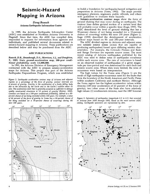
Figure 1. Earthquake acceleration contour map of <strong>Arizona</strong> and adjacent<br />
regions as a percentage of the force of gravity; contour <strong>in</strong>tervals are<br />
4 percent of gravity. Gravity is the acceleration of a freely fall<strong>in</strong>g body<br />
due to the attraction by the Earth and to the Earth's rotation about its<br />
axis. <strong>The</strong> acceleration level that is generally accepted as sufficient to damage<br />
weakly constructed structures is 10 percent of gravity (Richter, 1958).<br />
Contours are based on a 100-year conditional probability, def<strong>in</strong>ed as a 90<br />
percent chance of not be<strong>in</strong>g exceeded with<strong>in</strong> 100 years. For example, a value<br />
of 64 percent of the force of gravity <strong>in</strong> Yuma has a 90-percent chance of<br />
not be<strong>in</strong>g exceeded (or a 10-percent chance of occurr<strong>in</strong>g) dur<strong>in</strong>g the<br />
next 100 years.<br />
to build a foundation for earthquake-hazard mitigation and<br />
preparation <strong>in</strong> <strong>Arizona</strong> (Yates, 1992). <strong>The</strong> maps provide<br />
emergency planners, eng<strong>in</strong>eers, public officials, and others<br />
with guidel<strong>in</strong>es to evaluate these hazards.<br />
<strong>Seismic</strong>-acceleration contour maps show the force of<br />
ground shak<strong>in</strong>g that may occur dur<strong>in</strong>g an earthquake. <strong>The</strong><br />
contour l<strong>in</strong>es def<strong>in</strong>e ground motion of a certa<strong>in</strong> level that<br />
will probably occur with<strong>in</strong> a specific time (Euge, 1993). <strong>The</strong><br />
AEIC determ<strong>in</strong>ed the level of ground shak<strong>in</strong>g that has a<br />
90-percent chance of not be<strong>in</strong>g exceeded (or a lO-percent<br />
chance of occurr<strong>in</strong>g) with<strong>in</strong> the next 100 years (Figure 1).<br />
Euge (1993) described the development of acceleration<br />
contour maps based on 50- and 250-year <strong>in</strong>tervals.<br />
<strong>The</strong> AEIC divided regions <strong>in</strong> <strong>Arizona</strong> and adjacent areas<br />
<strong>in</strong>to seismic source zones (zones that are capable of<br />
produc<strong>in</strong>g earthquakes) based upon differ<strong>in</strong>g seismic characteristics.<br />
For example, the Colorado Plateau and Bas<strong>in</strong><br />
and Range Prov<strong>in</strong>ce are separate source zones. <strong>The</strong> most<br />
recent catalog of <strong>Arizona</strong> earthquakes published by the<br />
AEIC was used to def<strong>in</strong>e rates of earthquake occurrence<br />
with<strong>in</strong> each source zone. <strong>The</strong> rate of occurrence is based<br />
on an observed number of earthquakes of a given magnitude<br />
per time period and was determ<strong>in</strong>ed for each fault and<br />
seismic source zone. Where data were limited, the rates of<br />
occurrence were based on <strong>in</strong>terpretation.<br />
<strong>The</strong> high values for the Yuma area (Figure 1) are the<br />
result of high earthquake-occurrence rates for the faults that<br />
form the boundary of the North American and Pacific Plates<br />
with<strong>in</strong> southern California and northern Mexico. Although<br />
the Yuma region has the highest acceleration values with<strong>in</strong><br />
<strong>Arizona</strong> (lOO-year acceleration of 60 percent of the force of<br />
gravity), two other areas of the State also have relatively<br />
high values: (1) southeastern <strong>Arizona</strong>, near the 1887 Sonoran<br />
Figure 2. Epicenters of earthquakes (magnitude 0.5 to 6.2) that occurred<br />
<strong>in</strong> <strong>Arizona</strong> from 1830 through 1992, based on the most current AEIC<br />
catalog. Earthquake epicenters are represented by.dots.<br />
37 0 -1------~-<br />
I<br />
I<br />
!<br />
IIII<br />
36°<br />
4 <strong>Arizona</strong> Geology, vol. 23, no. 2, Summer 1993
earthquake epicenter (DuBois and Smith, 1980); and (2) a<br />
zone that extends from the Prescott-Flagstaff area through<br />
northwestern <strong>Arizona</strong>. <strong>The</strong> latter zone <strong>in</strong>cludes the Verde,<br />
Big Ch<strong>in</strong>o, Aubrey, and Hurricane fault systems, as well<br />
as a northwest-trend<strong>in</strong>g belt of earthquake epicenters.<br />
<strong>The</strong> 100-year conditional-probability map is published as<br />
a color plot at a scale of 1:1,000,000. General 50-, 100- and<br />
250-year acceleration contour maps are also available at<br />
small scales pr<strong>in</strong>ted on 8.5" x 11" sheets. Because the<br />
database for these maps conta<strong>in</strong>s approximately 4,000 data<br />
po<strong>in</strong>ts, sort<strong>in</strong>g techniques may be used to produce enlarged<br />
regional and areal maps.<br />
Morrison, S.J., Brumbaugh, D.S., and Daughton, T., 1991,<br />
State of <strong>Arizona</strong> maximum-<strong>in</strong>tensity ground-shak<strong>in</strong>g map<br />
(1887-1987): scale 1:1,000,000.<br />
This map illustrates the maximum Modified Mercalli<br />
Intensity levels for <strong>Arizona</strong> dUr<strong>in</strong>g the period between 1887<br />
and 1987. <strong>The</strong>se levels range from V to IX. <strong>The</strong> highest levels<br />
are near Yuma and <strong>in</strong> southeastern <strong>Arizona</strong> because of<br />
California earthquakes and the 1887 Sonoran earthquake,<br />
respectively (DuBois and Smith, 1980). <strong>The</strong> primary source<br />
of <strong>in</strong>tensity data was DuBois and others (1982).<br />
Acceleration describes the force of an earthquake, generally<br />
measured on bedrock, whereas <strong>in</strong>tensity describes<br />
actual earthquake effects on human structures. Acceleration<br />
typically decreases with distance from an earthquake; <strong>in</strong>tensity,<br />
however, may be <strong>in</strong>fluenced by unfavorable local<br />
geologic conditions, such as loose sandy soils or high<br />
ground water. This <strong>in</strong>fluence was clearly demonstrated by<br />
the devastation <strong>in</strong> the San Francisco Mar<strong>in</strong>a District about<br />
60 miles north of the epicenter of the 1989 Lorna Prieta<br />
earthquake (Bonilla, 1991). Similar geologic conditions <strong>in</strong><br />
Yuma Valley <strong>in</strong>creased the damage due to liquefaction and<br />
ground settlement dur<strong>in</strong>g the 1940 Imperial Valley earthquake<br />
(U.S. Bureau of Reclamation, 1976). In populated<br />
areas that are underla<strong>in</strong> by high ground water and loose<br />
sandy soils, <strong>in</strong>tensity maps may represent earthquake hazards<br />
more accurately than bedrock acceleration maps. A<br />
color plot of this map is available at a scale of 1:1,000,000.<br />
Brumbaugh, D.S., Morrison, 5.1., and Bausch, D.B., 1993,<br />
<strong>Arizona</strong> earthquakes, 1830-1992, catalog and map: 10 p.,<br />
scale 1:1,000,000.<br />
<strong>The</strong> catalog of earthquakes ma<strong>in</strong>ta<strong>in</strong>ed by the AEIC<br />
conta<strong>in</strong>s locations, orig<strong>in</strong> times, and magnitudes for 475<br />
<strong>Arizona</strong> earthquakes (Figure 2). <strong>The</strong> catalog's database<br />
format allows sort<strong>in</strong>g by date, time, location, or magnitude.<br />
In addition to locat<strong>in</strong>g <strong>Arizona</strong> earthquakes each year (see<br />
article on pages 2 and 3), the AEIC relocates earthquakes<br />
that occurred before the seismic network was established.<br />
<strong>The</strong> AEle completes this task by retriev<strong>in</strong>g the raw data<br />
(e.g., seismograms and phase arrival times) from various<br />
regional sources (e.g., the California Institute of Technology<br />
and the U.S. <strong>Geological</strong> <strong>Survey</strong>), comb<strong>in</strong><strong>in</strong>g these data with<br />
the network data, and us<strong>in</strong>g the most current crustalvelocity<br />
model. Last year, about a dozen earthquakes that<br />
occurred dur<strong>in</strong>g the 1950's and 1960's were relocated. Many<br />
of the epicenters were relocated from <strong>Arizona</strong> to California<br />
or Mexico.<br />
A color plot of this map is available at a scale of<br />
1:1,000,000. A pr<strong>in</strong>tout of the complete catalog with a smallscale,<br />
8.5" x 11" map may also be purchased.<br />
ORDERING INSTRUCTIONS<br />
<strong>The</strong> color plots of the three 1:1,000,OOO-scale maps discussed<br />
above are available for $20 each; the current catalog<br />
of <strong>Arizona</strong> earthquakes may be ordered for $5; all prices<br />
<strong>in</strong>clude shipp<strong>in</strong>g costs. Earthquake- or acceleration-data<br />
sort<strong>in</strong>g, such as epicenters by date, location, or magnitude,<br />
and enlarged regional acceleration maps may also be purchased.<br />
Send requests to the <strong>Arizona</strong> Earthquake Information<br />
Center, Northern <strong>Arizona</strong> University, P.O. Box 4099,<br />
Flagstaff, AZ 86011; tel: (602) 523-7197.<br />
REFERENCES<br />
Bonilla, M.G., 1991, <strong>The</strong> Mar<strong>in</strong>a district, 'San Francisco, California: Geology,<br />
history and earthquake effects: Bullet<strong>in</strong> of the Seismological Society of<br />
America, v. 81, no. 5, p. 1,958-1,979.<br />
DuBois, S.M., and Smith, A.W., 1980, <strong>The</strong> 1887 earthquake <strong>in</strong> San Bernard<strong>in</strong>o<br />
Valley, Sonora: Historic accounts and <strong>in</strong>tensity patterns <strong>in</strong> <strong>Arizona</strong>: <strong>Arizona</strong><br />
Bureau of Geology and M<strong>in</strong>eral Technology Special Paper 3, 112 p.<br />
DuBois, S.M., Smith, A.W., Nye, N.K., and Nowak, T.A., Jr., 1982, <strong>Arizona</strong><br />
earthquakes, 1776-1980: <strong>Arizona</strong> Bureau of Geology and M<strong>in</strong>eral Technology<br />
Bullet<strong>in</strong> 193, 456 p., scale 1:1,000,000.<br />
Euge, KM., 1993, <strong>Arizona</strong> develops new seismic-acceleration contour maps:<br />
<strong>Arizona</strong> Geology, v. 23, no. 1, p. 9.<br />
Richter, C.F., 1958, Elementary seismology: San Francisco, W.H. Freeman and<br />
Co., 768 p.<br />
U.S. Bureau of Reclamation, 1976, Record of earthquakes <strong>in</strong> the Yuma area,<br />
1776-1976: Special Report, 191 p.<br />
Yates, RA., 1992, <strong>Arizona</strong> Earthquake Preparedness Program: <strong>Arizona</strong> Geology,<br />
v. 22, no. 3, p. 4-5.<br />
<strong>Arizona</strong>n Confirmed for Key Interior Position<br />
Elizabeth Ann Rieke, Director of the <strong>Arizona</strong> Department<br />
of Water Resources s<strong>in</strong>ce April 1991, has been<br />
confirmed as Assistant Secretary for Water and Science,<br />
one of six Assistant Secretary positions <strong>in</strong> the<br />
U.S. Department of the Interior. Former <strong>Arizona</strong> Governor<br />
Bruce Babbitt was recently confirmed as Secretary<br />
of the Interior.<br />
Rieke began work on March 8. She adm<strong>in</strong>isters the<br />
U.S. <strong>Geological</strong> <strong>Survey</strong>, U.S. Bureau of M<strong>in</strong>es, and U.S.<br />
Bureau of Reclamation.<br />
From January 1987 to April 1991, Rieke worked for<br />
the law firm of Jenn<strong>in</strong>gs, Strouss and Salmon. From 1982<br />
through 1986, she served <strong>in</strong> the Legal Division of the<br />
<strong>Arizona</strong> Department of Water Resources as Deputy<br />
Counsel and Chief Counsel. She has participated <strong>in</strong><br />
Colorado River negotiations, statewide water-plann<strong>in</strong>g<br />
activities, and negotiations that led to significant legislation<br />
affect<strong>in</strong>g water management <strong>in</strong> <strong>Arizona</strong>. She<br />
recently served as Chair of the Governor's Task Force<br />
on Central <strong>Arizona</strong> Project issues.<br />
Rieke graduated from Oberl<strong>in</strong> College <strong>in</strong> 1965 and<br />
received her law degree from the University of <strong>Arizona</strong><br />
<strong>in</strong> 1981.<br />
<strong>Arizona</strong> Geology, vol. 23, no. 2, Summer 1993<br />
5


