Read PDF - Southwinds Magazine
Read PDF - Southwinds Magazine
Read PDF - Southwinds Magazine

Create successful ePaper yourself
Turn your PDF publications into a flip-book with our unique Google optimized e-Paper software.
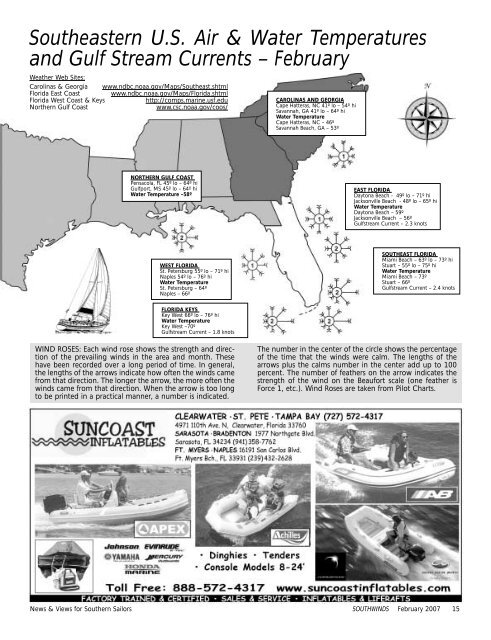
Southeastern U.S. Air & Water Temperatures<br />
and Gulf Stream Currents – February<br />
Weather Web Sites:<br />
Carolinas & Georgia www.ndbc.noaa.gov/Maps/Southeast.shtml<br />
Florida East Coast www.ndbc.noaa.gov/Maps/Florida.shtml<br />
Florida West Coast & Keys<br />
http://comps.marine.usf.edu<br />
Northern Gulf Coast<br />
www.csc.noaa.gov/coos/<br />
CAROLINAS AND GEORGIA<br />
Cape Hatteras, NC 41º lo – 54º hi<br />
Savannah, GA 41º lo – 64º hi<br />
Water Temperature<br />
Cape Hatteras, NC – 46º<br />
Savannah Beach, GA – 53º<br />
NORTHERN GULF COAST<br />
Pensacola, FL 45º lo – 64º hi<br />
Gulfport, MS 45º lo – 64º hi<br />
Water Temperature –58º<br />
EAST FLORIDA<br />
Daytona Beach - 49º lo – 71º hi<br />
Jacksonville Beach - 48º lo – 65º hi<br />
Water Temperature<br />
Daytona Beach – 59º<br />
Jacksonville Beach – 56º<br />
Gulfstream Current – 2.3 knots<br />
WEST FLORIDA<br />
St. Petersburg 55º lo – 71º hi<br />
Naples 54º lo – 76º hi<br />
Water Temperature<br />
St. Petersburg – 64º<br />
Naples – 66º<br />
SOUTHEAST FLORIDA<br />
Miami Beach – 63º lo – 73º hi<br />
Stuart – 55º lo – 75º hi<br />
Water Temperature<br />
Miami Beach – 73º<br />
Stuart – 66º<br />
Gulfstream Current – 2.4 knots<br />
FLORIDA KEYS<br />
Key West 66º lo – 76º hi<br />
Water Temperature<br />
Key West –70º<br />
Gulfstream Current – 1.8 knots<br />
WIND ROSES: Each wind rose shows the strength and direction<br />
of the prevailing winds in the area and month. These<br />
have been recorded over a long period of time. In general,<br />
the lengths of the arrows indicate how often the winds came<br />
from that direction. The longer the arrow, the more often the<br />
winds came from that direction. When the arrow is too long<br />
to be printed in a practical manner, a number is indicated.<br />
The number in the center of the circle shows the percentage<br />
of the time that the winds were calm. The lengths of the<br />
arrows plus the calms number in the center add up to 100<br />
percent. The number of feathers on the arrow indicates the<br />
strength of the wind on the Beaufort scale (one feather is<br />
Force 1, etc.). Wind Roses are taken from Pilot Charts.<br />
News & Views for Southern Sailors SOUTHWINDS February 2007 15