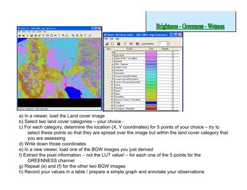
Brightness - Remote Sensing and GIS Laboratory
Brightness - Remote Sensing and GIS Laboratory
Brightness - Remote Sensing and GIS Laboratory

Create successful ePaper yourself
Turn your PDF publications into a flip-book with our unique Google optimized e-Paper software.
a) In a viewer, load the L<strong>and</strong> cover image<br />
b) Select two l<strong>and</strong> cover categories – your choice -<br />
c) For each category, determine the location (X, Y coordinates) for 5 points of your choice – try to<br />
select these points so that they are spread over the image but within the l<strong>and</strong> cover category that<br />
you are assessing<br />
d) Write down those coordinates<br />
e) In a new viewer, load one of the BGW images you just derived<br />
f) Extract the pixel information – not the LUT value! – for each one of the 5 points for the<br />
GREENNESS channel<br />
g) Repeat (e) <strong>and</strong> (f) for the other two BGW images<br />
h) Record your values in a table / prepare a simple graph <strong>and</strong> annotate your observations