Ebury Planning Brief cover.indd - Westminster City Council
Ebury Planning Brief cover.indd - Westminster City Council
Ebury Planning Brief cover.indd - Westminster City Council

Create successful ePaper yourself
Turn your PDF publications into a flip-book with our unique Google optimized e-Paper software.
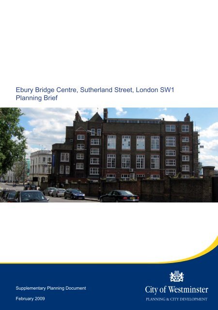
<strong>Ebury</strong> Bridge Centre, Sutherland Street, London SW1<br />
<strong>Planning</strong> <strong>Brief</strong><br />
Supplementary <strong>Planning</strong> Document<br />
February 2009
<strong>Ebury</strong> Bridge Centre Panning <strong>Brief</strong><br />
Document title:<br />
<strong>Ebury</strong> Bridge Centre, Sutherland Street, SW1V - <strong>Planning</strong> <strong>Brief</strong><br />
Date: February 2009<br />
Status:<br />
Adopted as a Supplementary <strong>Planning</strong> Document<br />
Produced by:<br />
<strong>City</strong> of <strong>Westminster</strong><br />
<strong>City</strong> <strong>Planning</strong> Group<br />
<strong>City</strong> Hall, 64 Victoria Street<br />
London SW1E 6QP<br />
Contact:<br />
Rachael Ferry-Jones/ Sara Dilmamode<br />
rferry-jones@westminster.gov.uk / sdilmamode@westminster.gov.uk /<br />
020 7641 2418 / 3983 Fax: 020 7641 3050<br />
2
<strong>Ebury</strong> Bridge Centre Panning <strong>Brief</strong><br />
Contents<br />
Contents.................................................................................................................... 3<br />
Executive Summary ................................................................................................. 4<br />
1.0 Introduction......................................................................................................... 5<br />
2.0 Background and <strong>Planning</strong> <strong>Brief</strong> Objectives ..................................................... 7<br />
3.0 The Site, <strong>Planning</strong> History and Surrounding Location.................................... 9<br />
4.0 <strong>Planning</strong> Policy Framework............................................................................. 16<br />
5.0 Potential Land Uses ......................................................................................... 18<br />
6.0 Conservation, Design and Sustainable Development................................... 24<br />
7.0 Transport, Highways and Parking................................................................... 29<br />
8.0 <strong>Planning</strong> Obligations........................................................................................ 31<br />
9.0 Contacts and Further Information................................................................... 33<br />
Appendix 1 Sustainability Appraisal..................................................................... 35<br />
Glossary .................................................................................................................. 45<br />
Bibliography............................................................................................................ 52<br />
3
<strong>Ebury</strong> Bridge Centre Panning <strong>Brief</strong><br />
Executive Summary<br />
<strong>Westminster</strong> Adult Education Service (WAES) and their consultants have considered<br />
their service strategy for the 21 st Century and have concluded that their existing<br />
premises are poorly located and unsuitable for the range of activities that they wish to<br />
provide. In 2006 WAES developed a property strategy which concluded that by<br />
disposing of their two main sites, which includes the <strong>Ebury</strong> Bridge Centre, funding<br />
could be raised to build a state of the art centre on an alternative site within the city.<br />
On 10 th December 2007 the council’s Cabinet approved the principle of the strategy<br />
and agreed that further design work could be commissioned in respect of developing<br />
proposals for a new purpose built facility at the council owned site at Moxon Street,<br />
W1.<br />
This planning brief has therefore been prepared in response to the development<br />
opportunities that have arisen as a result of the council’s review of its operational<br />
requirements for WAES. It comprises one in a suite of interlinked briefs that have<br />
been produced in order to respond to the overall WAES Property Strategy. The<br />
purpose of the planning briefs is to set out the council’s detailed planning<br />
considerations, giving a clear steer on the planning policy requirements for the<br />
various sites affected by the WAES property strategy<br />
The continued use of the <strong>Ebury</strong> Bridge site as a community facility is encouraged in<br />
recognition of the essential role of community facilities. Subject to addressing policies<br />
of the UDP, redevelopment of the site for residential purposes, incorporating an<br />
alternative community facility may also be an appropriate form of development.<br />
Development at the site would need to consider the relationship with the railway line<br />
carefully and incorporate sustainable design measures. The form and design and<br />
buildings on the site must also be appropriate to the setting of the adjacent Peabody<br />
Estate and Pimlico Conservation Areas, and must not materially harm daylight and<br />
sunlight to neighbouring residential properties.<br />
4
<strong>Ebury</strong> Bridge Centre Draft Panning <strong>Brief</strong><br />
1.0 Introduction<br />
1.1 The <strong>Ebury</strong> Bridge Centre is located on Sutherland Street in the south-west of<br />
the city. It is currently occupied by <strong>Westminster</strong> Adult Education Service<br />
(WAES). This planning brief has been prepared in response to a property<br />
strategy which has been developed by WAES to identify ways in which the<br />
buildings they use can promote and improve their core services. Their goal is<br />
to ensure that the excellence of their current educational service is not only<br />
sustained but is greatly enhanced through the provision of quality and purpose<br />
built accommodation. The property strategy concludes that by disposing of the<br />
two main WAES sites (Amberley Road and <strong>Ebury</strong> Bridge) funding can be<br />
raised to build a state of the art centre on an alternative site within the <strong>City</strong>.<br />
1.2 The purpose of this brief is therefore to set out the <strong>City</strong> of <strong>Westminster</strong>’s<br />
planning considerations relating to the disposal and potential redevelopment<br />
of the <strong>Ebury</strong> Bridge site. The brief provides a site specific supplement to the<br />
provisions of the <strong>City</strong> of <strong>Westminster</strong> Unitary Development Plan (UDP),<br />
(Adopted 2007), and sets out the matters which would be required to be<br />
addressed in a planning application for the redevelopment of the site.<br />
Accordingly, it provides information for potential developers and their<br />
consultants and representatives, surrounding landowners, residents and other<br />
stakeholders.<br />
1.3 This brief is a revised version of the draft planning brief for the <strong>Ebury</strong> Bridge<br />
Centre that was approved on 16 June 2008 by the <strong>Planning</strong> Sub-Committee<br />
(<strong>Planning</strong> <strong>Brief</strong>s and Local Development Framework) for public consultation.<br />
The draft brief was the subject of extensive consultation with key stakeholders<br />
and where appropriate the main issues raised have been addressed in the<br />
revisions to the brief. A full report setting out the planning considerations on<br />
the representations made was presented to the <strong>Planning</strong> Sub-Committee<br />
(<strong>Planning</strong> <strong>Brief</strong>s and Local Development Framework) on 14 October 2008.<br />
1.4 On 14 October 2008 the <strong>Planning</strong> Sub-Committee (<strong>Planning</strong> <strong>Brief</strong>s and Local<br />
Development Framework) agreed to recommend to the Cabinet Member for<br />
Built Environment that the revised brief be adopted as a Supplementary<br />
<strong>Planning</strong> Document (SPD). Following the incorporation of minor amendments<br />
requested by the committee the Cabinet Member for Built Environment agreed<br />
to adopt this brief as an SPD. It is therefore a material consideration in<br />
determining any planning applications for the site.<br />
1.5 Relevant Government legislation requires Development Plan Documents<br />
(DPD) and Supplementary <strong>Planning</strong> Documents (SPD) to be subject to<br />
sustainability appraisals incorporating Strategic Environmental Assessment<br />
(SEA). Included at Appendix 1 is a sustainability appraisal of this planning<br />
brief which has incorporated the requirements of <strong>Planning</strong> Policy Statement 12<br />
(PPS 12) and the SEA Directive, and is based on the methodology set out in<br />
the ODPM document Sustainability Appraisal of Regional Spatial Strategies<br />
and Local Development Documents (November 2005). This amends an initial<br />
5
<strong>Ebury</strong> Bridge Centre Panning <strong>Brief</strong><br />
sustainability appraisal of the consultation draft of this brief. The Sustainability<br />
Appraisal process has informed the policy guidance set out in this planning<br />
brief.<br />
6
<strong>Ebury</strong> Bridge Centre Panning <strong>Brief</strong><br />
2.0 Background and <strong>Planning</strong> <strong>Brief</strong> Objectives<br />
Background to the brief<br />
2.1 The <strong>Westminster</strong> Adult Education Service (WAES) is one of the largest<br />
providers of local authority adult education in the United Kingdom and has<br />
developed as a highly successful provider in the education and training sector<br />
gaining a reputation as one of the leading services nationally. This was<br />
externally verified following an inspection by the Adult Learning Inspectorate<br />
(ALI) in November 2005. The Inspectorate did however, highlight in the report<br />
the inadequacies of the accommodation within which WAES operates. In<br />
response, and as part of the ‘One <strong>City</strong>’ programme, the council has made a<br />
commitment to improve the accommodation for WAES.<br />
2.2 WAES currently operates from two main centres, one in the North of<br />
<strong>Westminster</strong> (Amberley Centre) and one in the South (<strong>Ebury</strong> Bridge Centre)<br />
and, in addition, it delivers classes in over 80 other venues across<br />
<strong>Westminster</strong>. The report from the ALI inspection advised that action was<br />
urgently needed to address the poor accommodation being used. A full<br />
inspection, commissioned by the council, of the Service’s two main centres at<br />
Amberley and <strong>Ebury</strong> has now been undertaken and concludes that both<br />
centres are no longer fit for purpose. In addition, the buildings are expensive<br />
to maintain and their costs are likely to increase.<br />
2.3 The WAES Property Strategy (2006) provides a further assessment of the<br />
WAES estate in the context of the operational requirements and considers a<br />
number of options to improve the teaching facilities. The strategy concludes<br />
that the council should sell both the Amberley and <strong>Ebury</strong> sites and use the<br />
capital receipts to provide a new, state of the art, purpose built main centre on<br />
an alternative site in the <strong>City</strong> of <strong>Westminster</strong> along with three additional<br />
satellite centres across the city. One of the satellite facilities will be included in<br />
Pimlico School, which is approximately 0.5km from the <strong>Ebury</strong> Bridge Centre.<br />
Implementation of this option would therefore render the Amberley and <strong>Ebury</strong><br />
Bridge sites surplus to the requirements of WAES (except insofar as any<br />
satellite centre might be located within a development of the Amberley site).<br />
2.4 A joint report by the council’s Director of Finance and Resources and Director<br />
of Adult Social Services on the status of the property strategy was presented<br />
to the council’s Cabinet on 10 December 2007. Following their consideration<br />
the principle of the strategy was approved and it was agreed that further<br />
design work would be commissioned in respect of developing proposals for a<br />
new purpose built facility at the council owned site at Moxon Street, W1. It was<br />
also agreed that an application be submitted to the Learning and Skills <strong>Council</strong><br />
for funding towards this Centre and that the matter be further considered in<br />
Spring 2008 in the light of the detailed feasibility study, the outcome of the<br />
funding application, further work on planning risks, and public consultation to<br />
be carried out by WAES.<br />
2.5 A further report on the status of the WAES property strategy was presented to<br />
the council’s Cabinet on the 14 th April 2008. This report confirmed that an<br />
7
<strong>Ebury</strong> Bridge Centre Panning <strong>Brief</strong><br />
application to the LSC for funding had been submitted in January 2008.<br />
Cabinet also reaffirmed its support for the location of the new WAES centre at<br />
Moxon Street.<br />
2.6 On 29 th April 2008 the National Committee of the LSC considered the<br />
application for funding and formally ratified the full amount sought of £9.2<br />
million.<br />
<strong>Planning</strong> <strong>Brief</strong> Objectives<br />
2.7 This planning brief has therefore been prepared in response to the<br />
development opportunities that have arisen as a result of the council’s review<br />
of its land ownership and operational requirements for WAES. It comprises<br />
one in a suite of interlinked briefs that have been produced in order to respond<br />
to the overall WAES Property Strategy. This brief should therefore also be<br />
read in conjunction with the planning briefs for the following sites:<br />
Amberley Centre, Amberley Road, W9 (planning brief, February 2009)<br />
Moxon Street Car Park, W1 (planning brief, February 2009)<br />
Prince of Wales Junction, Harrow Road, W9 (the possible location of a new<br />
‘satellite’ centre will be considered in the draft planning brief which is<br />
currently being prepared for this site)<br />
2.8 The purpose of the planning brief is to set out the council’s detailed planning<br />
considerations, giving a clear steer on the planning policy requirements for the<br />
various sites. In summary this brief seeks to:<br />
set out in detail the opportunities and challenges for the <strong>Ebury</strong> Centre site’s<br />
redevelopment<br />
outline the relevant planning policy<br />
promote appropriate land uses which address the planning policy context<br />
and represent an appropriate response to the existing character of the area<br />
promote a mix of suitable land uses which adhere to the core components<br />
of the UDP, in a development of high quality architecture and urban design<br />
provide a framework for local and stakeholder consultation<br />
assist the planning application and development processes to meet the<br />
council’s policies and local needs.<br />
8
<strong>Ebury</strong> Bridge Centre Panning <strong>Brief</strong><br />
3.0 The Site, <strong>Planning</strong> History and Surrounding<br />
Location<br />
3.1 The <strong>Ebury</strong> Bridge Centre is located on Sutherland Street, at the western edge<br />
of Pimlico, in the south of the city. The triangle shaped site is bound by<br />
Sutherland Street to the east, Peabody Avenue to the south and the<br />
overground railway lines from Victoria to the west. The <strong>Ebury</strong> Bridge Centre’s<br />
main building is located at the southern part of the site and <strong>Westminster</strong><br />
council has a temporary cleansing depot currently occupying the northern part<br />
of the site. There is a shared pedestrian and vehicular access to the site from<br />
Sutherland Street. The site area is 0.2 hectares (see Map 1 below).<br />
Map 1 – Site location Plan<br />
3.2 <strong>Ebury</strong> Bridge Centre is a red brick Victorian building originally constructed as a<br />
school. The building viewed from the north has a five part structure. The floor<br />
to ceiling heights vary. The central section of the building is three storeys<br />
above ground level plus a recessed roof storey. To the west and east there<br />
are five storey to seven storey sections; these do not exceed the roof line of<br />
the central section. Finally, to the east there is a much lower section of three<br />
storeys on the Sutherland Street frontage (see photograph below). Much of<br />
the southern elevation has three tall storeys, with part rising to a fourth storey.<br />
9
<strong>Ebury</strong> Bridge Centre Panning <strong>Brief</strong><br />
<strong>Ebury</strong> Bridge Centre Building<br />
3.3 The building although a good example of its type, is not of sufficient special<br />
architectural or historic interest to warrant listing, but does have some<br />
attractive architectural features. The main building and the school keeper’s<br />
building to the side of the main building are in a poor state of repair.<br />
3.4 There has been a number of alterations to the building including a single<br />
storey extension to the ground level at the front of the building and the<br />
rebuilding of part of its upper floors. The ground level extension is of<br />
reasonable quality and does not materially harm the appearance of the<br />
building, but equally does not represent a very sensitive response to its<br />
architecture.<br />
3.5 The building faces north onto a court yard in which there are three disabled<br />
parking bays and the cleansing depot. The cleansing depot is located on the<br />
northern part of the site on an area previously used for car parking for the<br />
<strong>Ebury</strong> Bridge Centre and which was originally the school playground. The<br />
cleansing depot has a temporary planning permission expiring on 31 January<br />
2009. There are provisions for the relocation of the depot to Grosvenor<br />
Waterside development in 2009.<br />
3.6 The cleansing depot is fenced off from the <strong>Ebury</strong> Bridge Centre building and<br />
courtyard and is occupied by two single-storey portacabins which<br />
accommodate the cleansing depot offices. Much of the remainder of the depot<br />
site is given over to parking.<br />
<strong>Planning</strong> history<br />
3.7 The <strong>Ebury</strong> Bridge Centre building was originally constructed for education<br />
purposes. There have been several applications for a variety of minor<br />
10
<strong>Ebury</strong> Bridge Centre Panning <strong>Brief</strong><br />
alterations to the <strong>Ebury</strong> Centre building such as the replacement of windows.<br />
More significantly, in 1993 permission was granted for the glass panelled<br />
entrance canopy (92/07134).<br />
3.8 Temporary permission was granted for the use of the car parking area to the<br />
northern part of the site as a <strong>Westminster</strong> <strong>City</strong> <strong>Council</strong> Cleansing depot in<br />
2003. A further temporary permission for the continued use was granted in<br />
2005, permitting the use of the site as a cleansing depot to 31 January 2009.<br />
Surrounding location<br />
3.9 The <strong>Ebury</strong> Bridge Centre is located in a residential area. Buckingham Palace<br />
Road some 230 metres to the north-west of the site is characterised by a<br />
mixture of residential and major office uses with the intensity of commercial<br />
development increasing north along Buckingham Palace Road towards<br />
Victoria. However, the predominant use on streets surrounding the site is<br />
residential (see Map 2, below).<br />
Map 2 – Land Uses<br />
3.10 The architectural character of the area around the site is diverse. There is an<br />
interesting juxtaposition of architectural styles and periods including grand mid<br />
19th century classical terraces, late 19th century tenement style blocks, postwar<br />
low rise housing estates and the Victorian <strong>Ebury</strong> Centre former school<br />
building itself. Building heights in the area immediately surrounding are<br />
11
<strong>Ebury</strong> Bridge Centre Panning <strong>Brief</strong><br />
generally from four to six storeys. Glastonbury House on Warwick Way is the<br />
only exception to this and rises to twenty-two storeys.<br />
3.11 The post-war Abbots Manor housing estate (built in stages from 1950s –<br />
1970s), is located to the east of the site. The southern part of the housing<br />
estate, nearest to the site, is predominantly composed of six storey blocks<br />
arranged around a central green housing amenity space.<br />
3.12 Abbots Manor Nursery is located on Abbots Manor housing estate. It is a<br />
single storey portacabin sandwiched between Fonthill House and the adjacent<br />
Kirkstall House on what would have been housing estate open space (areas of<br />
communal open space for residents of the housing estate). The nursery has a<br />
small all-weather play area associated with it and the perimeter is heavily<br />
planted including a number of mature trees. Further to the north is a small<br />
children’s play area in a slightly sunken area at the junction of Sutherland<br />
Street and <strong>Ebury</strong> Bridge.<br />
3.13 Peabody Avenue Conservation Area is immediately to the south of the site.<br />
The rear of the <strong>Ebury</strong> Centre faces the two four storey tenement style<br />
residential blocks that flank either side of the Avenue, and benefits from views<br />
along the whole Avenue’s length. The tenement buildings date from the 1870s<br />
although there is a more recent extension to the southern end of the tenement.<br />
There are views from the south of the site to Battersea Power Station. The<br />
Grosvenor Waterside development is also visible from Sutherland Street to the<br />
south west of the site.<br />
3.14 Pimlico conservation are reaches to within 20 metres of the site. Turpentine<br />
Lane, to the south east, is a narrow, attractive street lined by terraces and<br />
modern, well integrated stucco terrace infill development. The Grade II listed<br />
White Ferry House Public House sits at the junction of Turpentine Lane and<br />
Sutherland Street and beyond this are the 19th century cream stucco terraces<br />
of Pimlico. The terraces are in the classical tradition predominantly of four to<br />
five storeys over a basement. There are a number of listed buildings in the<br />
Conservation area including the White Ferry pub, and no’s 13-31 Sutherland<br />
Street, which are Grade II listed, in relatively close proximity to the site (see<br />
Map 3, below).<br />
12
<strong>Ebury</strong> Bridge Centre Panning <strong>Brief</strong><br />
Map 3 Listed Buildings<br />
3.15 The railway line is to the west of the site, which separates Pimlico from the<br />
<strong>Ebury</strong> Estate and other residential areas to the north west. The railway line<br />
extends south past the Peabody estate. Parallel with the railway lines is an<br />
operational train depot. There is a signalling facility and the major train sidings<br />
and shed which serve the east, or Kent side of Victoria Station and<br />
accommodate South Eastern trains.<br />
3.16 In terms of the wider strategic planning policy context, the <strong>Ebury</strong> Bridge Centre<br />
site is within 600 metres of Victoria Station, the heart of one of the <strong>City</strong>’s major<br />
areas of change and development. To the north east lies Victoria Station (4.53<br />
hectares) and Victoria Coach Station (a split site of 1.36 hectares) which are<br />
identified as opportunity areas in the <strong>Westminster</strong> UDP (OP8). Victoria is also<br />
designated as an ‘Area for Intensification’ in the London Plan. The extensive<br />
redevelopment potential of sites in the Victoria area is the subject of the<br />
council’s Victoria Area <strong>Planning</strong> <strong>Brief</strong> adopted in 2006 (see Map 4, below).<br />
13
<strong>Ebury</strong> Bridge Centre Panning <strong>Brief</strong><br />
Map 4 – Wider <strong>Planning</strong> Context (showing Victoria, Chelsea Barracks and<br />
Pimlico School <strong>Planning</strong> <strong>Brief</strong> areas)<br />
Constraints and potential for development<br />
3.17 The <strong>Ebury</strong> Bridge Centre is in a prominent location on the bridge and is visible<br />
from <strong>Ebury</strong> Estate on the other side of the railway to the north west of the site.<br />
The building is not listed, and there are no other listed buildings or structures<br />
on the site. While the site is not within a Conservation Area, it should be noted<br />
that it abuts the Peabody Avenue Conservation Area and is also adjacent to<br />
the Pimlico Conservation Area. Therefore particular regard will be had to the<br />
proposed scale, massing and layout. More detail on the appropriate design<br />
response is set out in Section 6 of this planning brief.<br />
3.18 The <strong>Council</strong> is not aware of any plans for either the signalling facility or major<br />
train sidings and shed to the west of the site to be relocated, so until advised<br />
otherwise it is assumed they will remain in their current uses. However, if<br />
these uses were to change the relationship to the <strong>Ebury</strong> Bridge site would<br />
need to be reconsidered. The need to retain access to the railway line from the<br />
site will need to be established with Network Rail and considered in any<br />
redevelopment.<br />
3.19 Redevelopment should encompass the whole site, including the north part of<br />
the site currently used temporarily as a cleansing depot. A comprehensive<br />
redevelopment will avoid prejudicing future development on the north of the<br />
site and will potentially allow a better design solution. It is intended that the<br />
14
<strong>Ebury</strong> Bridge Centre Panning <strong>Brief</strong><br />
depot will be re-provided in 2009 within the Grosvenor Waterside<br />
development, on the other side of the railway lines, to the south of the site.<br />
15
<strong>Ebury</strong> Bridge Centre Panning <strong>Brief</strong><br />
4.0 <strong>Planning</strong> Policy Framework<br />
4.1 This brief provides guidance to potential developers on the uses and form of<br />
development that may be considered acceptable on the planning brief site.<br />
The brief sets out the planning policies and other material considerations<br />
relevant to the development of the site, which will be taken into account by the<br />
council in considering any application. Proposals will be judged on their merits<br />
against the criteria set out in this planning brief, the current adopted Unitary<br />
Development Plan (UDP) 2007, the emerging Local Development Framework<br />
(LDF), the London Plan and relevant national guidance notes, policies and<br />
instruments.<br />
4.2 The statutory development plan for <strong>Westminster</strong> is the UDP, adopted January<br />
2007. The council intends to “save” all the policies in the UDP for a minimum<br />
of 3 years, until at least January 2010. Some UDP policies may be saved<br />
beyond 3 years, subject to the approval of the Secretary of State. During this<br />
time the Core Strategy Development Plan Document (DPD) and <strong>City</strong><br />
Management DPD are being prepared which when adopted, will supersede<br />
UDP policies.<br />
4.3 The London Plan (consolidated with changes since 2004) (2008) is the Spatial<br />
Development Strategy for Greater London and together with the <strong>City</strong> of<br />
<strong>Westminster</strong>’s UDP, they form the current as well as the most important<br />
development plans to be considered for the purpose of understanding the<br />
policy context for this planning brief.<br />
4.4 The London Plan includes an indicative Central Activities Zone (CAZ), which<br />
extends a considerable way beyond <strong>Westminster</strong>’s CAZ shown in the UDP,<br />
and the previous version of the CAZ in the London Plan. Different UDP<br />
policies apply to sites inside and outside of the CAZ, for reasons explained in<br />
the UDP. The <strong>Ebury</strong> Bridge site is located outside of the CAZ as determined<br />
by the UDP; however, it falls within the London Plan’s extended zone. The<br />
council has sought legal advice on the implications of this and has concluded<br />
that whilst this is a material consideration the London plan relies on<br />
forthcoming Development Plan Documents and other, as yet unpublished,<br />
policy documents for the implementation of the revised CAZ. In due course the<br />
council will need to define the boundary of the CAZ within its administrative<br />
area.<br />
4.5 In addition to the strategic policy framework set out in the London Plan, and<br />
the UDP, the following supplementary planning guidance and documents will<br />
also be pertinent to the development of this site.<br />
The Government’s <strong>Planning</strong> Policy Guidance (PPG) notes and replacement<br />
<strong>Planning</strong> Policy Statements (PPS), particularly:<br />
- PPS1 (Delivering Sustainable Development),<br />
- PPS3 (Housing)<br />
- PPS12 (Local Spatial <strong>Planning</strong>),<br />
- PPG13 (Transport),<br />
16
<strong>Ebury</strong> Bridge Centre Panning <strong>Brief</strong><br />
- PPS25 (Development and Flood Risk)<br />
The Mayor’s Transport Strategy and revisions (2001 & 2004);<br />
The <strong>City</strong> of <strong>Westminster</strong>’s 5 Year One <strong>City</strong> Programme, launched<br />
November 2005;<br />
The <strong>Westminster</strong> <strong>City</strong> Plan (<strong>Westminster</strong>’s Sustainable Communities<br />
Strategy) adopted November 2006;<br />
The <strong>City</strong> Of <strong>Westminster</strong> Victoria Area <strong>Planning</strong> <strong>Brief</strong>, adopted 2006;<br />
The <strong>City</strong> of <strong>Westminster</strong> Open Space Strategy, Supplementary <strong>Planning</strong><br />
Document, 2007<br />
The <strong>City</strong> of <strong>Westminster</strong>’s various other Supplementary <strong>Planning</strong> Guidance<br />
/ Documents.<br />
17
<strong>Ebury</strong> Bridge Centre Draft Panning <strong>Brief</strong><br />
5.0 Potential Land Uses<br />
5.1 This section considers the possible range of land uses which may be<br />
considered acceptable in any redevelopment proposals for the site. The land<br />
uses set out are not exhaustive and all proposals will be assessed on the<br />
impacts of proposed uses and development form on the townscape and<br />
amenity of nearby residential communities. All redevelopment proposals<br />
should accord with the relevant policies and criteria set out in the UDP.<br />
Social and Community Facilities<br />
5.2 The UDP seeks to ensure that there is an adequate range of community<br />
facilities across <strong>Westminster</strong> (policy SOC 1). However, the UDP recognises<br />
that the operation and management of these services are beyond its scope.<br />
The release of the <strong>Ebury</strong> Centre site for redevelopment stems from the<br />
objective to provide a new replacement main <strong>Westminster</strong> Adult Education<br />
Centre and 3 supporting satellite centres. The WAES property strategy<br />
concluded that a central main centre location would be much more accessible<br />
by public transport than the <strong>Ebury</strong> Bridge and Amberley centres. Furthermore,<br />
in addition to a new main centre facility they are proposing to develop three<br />
‘satellite centres’ one of which will be located near the <strong>Ebury</strong> Bridge site at<br />
Pimlico School (which is approximately 0.5km away).<br />
5.3 The existing use of the <strong>Ebury</strong> Bridge Centre site is for education purposes<br />
(planning use class D1) and there is temporary permission for use of part of<br />
the site as a cleansing depot (sui generis). The use of the site for education<br />
purposes is considered to be a community use and as such, is subject to<br />
policy SOC1 which sets out a general presumption against the loss of<br />
community facilities. While use of the whole site for an alternative community<br />
use would be supported, Policy SOC1 does allow for the redevelopment of<br />
community facilities for alternate uses where the facility is surplus to the needs<br />
of the existing provider and a replacement facility is provided: (a) on the same<br />
site; (b) in parts of <strong>Westminster</strong> where there is a need for the facility; or (c)<br />
elsewhere in <strong>Westminster</strong> (UDP, paragraph 6.14).<br />
5.4 From a planning perspective in order to satisfy the requirements of policies<br />
STRA 5 and SOC1 the issues to consider are focussed on whether the needs<br />
of the <strong>City</strong>’s residents will be met by an adult education service which is fit for<br />
purpose in both quantitative and qualitative terms and in geographical<br />
distribution. For these reasons the planning brief requires a full and detailed<br />
impact assessment to be provided for consideration as part of any planning<br />
application that includes the loss of the site as an adult education centre. This<br />
impact assessment should justify, in detail, the decision to locate the main<br />
WAES centre on the Moxon Street site and include an analysis of why<br />
alternative sites were not considered appropriate. It should also include<br />
detailed information on why the existing sites are unsuitable. This assessment<br />
must also incorporate the following information:<br />
18
<strong>Ebury</strong> Bridge Centre Draft Panning <strong>Brief</strong><br />
Details of the existing and proposed availability, suitability and accessibility<br />
of facilities to serve the needs of the whole community demonstrating how<br />
the proposed strategy provides an enhanced service for its users. This<br />
analysis should <strong>cover</strong> the whole of the <strong>City</strong> and information should be<br />
broken down on an area by area basis. It would be useful if information<br />
could be gathered by post codes to ensure that an accurate assessment is<br />
made. This assessment should also consider public transport accessibility<br />
for each area.<br />
Details of the existing adult education programmes on offer by other<br />
providers and their geographical distribution.<br />
Justification of why the loss of the service in each location of the <strong>City</strong> is<br />
considered to be acceptable demonstrating how the adult educational<br />
needs of the residents in each area of the <strong>City</strong> would still be met. This<br />
should also include consideration of adult education services by other<br />
providers.<br />
Information on how the proposed satellite centres would assist in meeting<br />
demand along with detail on what the commitment is to the location of the<br />
satellite centres, including information on the feasibility of locating the north<br />
area satellite centre on the Amberley site.<br />
Review of existing floorspace against that proposed providing a full<br />
justification of any decrease or increase in floorspace. (The planning<br />
consideration normally relates to gross floorspace, but this review could<br />
usefully assess as well the existing and proposed net usable WAES<br />
floorspace, given the inefficiency of the existing buildings).<br />
Details of how the WAES service will be maintained throughout the<br />
implementation of proposals for each site including the construction period<br />
of the new main centre and various satellite centres. This should include<br />
details of overall project timescales and a clear commitment to demonstrate<br />
how a full WAES service is to be retained throughout the project.<br />
Assurances would be sought to reflect the following:<br />
- that no existing sites will be closed until the new main purpose built<br />
centre has opened;<br />
- that the Amberley Centre will not close until the north satellite centre<br />
has opened (or if this centre is to be part of the Amberley site<br />
redevelopment, how services will continue to be provided in the north<br />
during the development work);<br />
- that the <strong>Ebury</strong> Bridge Centre will not close until the south satellite<br />
centre (within the redeveloped Pimlico School) has opened;<br />
- that the existing premises in Soho (Frith Street) will not close until a<br />
new Central satellite centre has opened (or if Frith Street is to be<br />
refurbished and reused, how services will continue to be provided in the<br />
area during the development work).<br />
Details of the public consultation exercise to be carried out by WAES in<br />
accordance with the resolution of the council’s Cabinet on 10 th December<br />
2007. This should include full details of the extent of consultation and public<br />
responses.<br />
5.5 The impact assessment should provide a means by which the effects of the<br />
WAES proposals on the community and how it functions can be better<br />
understood. In some cases this type of assessment can assist in supporting<br />
19
<strong>Ebury</strong> Bridge Centre Draft Panning <strong>Brief</strong><br />
the case for an exception to be made to some relevant UDP criteria. The<br />
assessment should be written as a public document to be submitted as part of<br />
a planning application. The report, and consultation responses to it, will be<br />
taken in to account when making a decision on the merits of development<br />
proposals for the various sites and how they affect the community.<br />
5.6 In the event that the impact assessment provides the justification that the<br />
<strong>Ebury</strong> Bridge site is surplus to the WAES services needs Paragraph 6.14 of<br />
the UDP allows the consideration of the loss of a community facility if an<br />
adequate replacement facility is provided. Notwithstanding this, the UDP also<br />
recognises that the redevelopment of a community facility for another use<br />
could allow a better community facility to be provided. Policy SOC 1 of the<br />
UDP stipulates that where the facility is surplus to the needs of the existing<br />
provider, any new development on the site should include an alternative<br />
community facility which is needed in the area. Whilst under the current<br />
proposals WAES have advised that their facility would be replaced elsewhere<br />
in <strong>Westminster</strong> any proposed redevelopment of the site should aim to provide<br />
an alternative community facility that is needed in the area and to compensate<br />
for the loss of the current sole use of this site for community uses.<br />
5.7 Developers should consult with the community at the earliest opportunity and<br />
in advance of submitting a planning application not least in relation to any<br />
onsite community facility. Developers are encouraged to work closely with the<br />
South <strong>Westminster</strong> Renewal Partnership (see section 9.0 for contact details),<br />
who will be able to facilitate links to local stakeholders and provide advice on<br />
community priorities. As part of this pre-application consultation, early<br />
engagement with <strong>Westminster</strong> Primary Care Trust (PCT) is also encouraged.<br />
<strong>Westminster</strong> PCT has advised that the <strong>Ebury</strong> site is located in one of their<br />
greatest areas of health need and would like to explore whether the site would<br />
be suitable for PCT facility.<br />
Residential<br />
5.8 The site is outside of Central Activities Zone and the UDP states that the<br />
<strong>Council</strong> will seek to maximise the amount of new housing (Policy STRA 14)<br />
and to maximise the amount of land or buildings in residential use (Policy H3).<br />
The character of the surrounding area and close proximity of the residential<br />
Peabody Avenue suggests residential use or a residential led use may be<br />
appropriate on this site, subject to satisfactorily addressing the community<br />
facility policies highlighted above. Regard should be had to the <strong>Council</strong>’s<br />
policies for housing, which are contained in Chapter 3 of the UDP.<br />
5.9 The site lies in an area with a zoned residential density range of 250-500<br />
habitable rooms per hectare (Policy H 11 (A)). The site is in close proximity to<br />
public transport facilities; however, public transport access is not the sole<br />
factor in determining appropriate density; the character of the area and<br />
relationship with surrounding buildings is an essential consideration. The<br />
council is generally more concerned that proposed developments meet other<br />
policies in the plan than the measure of their housing density.<br />
5.10 In line with policies STRA 14 and H 4 of the UDP, the <strong>Council</strong> will seek the<br />
provision of affordable housing as part of any housing development of 10 or<br />
20
<strong>Ebury</strong> Bridge Centre Draft Panning <strong>Brief</strong><br />
more residential units on this site. The amount of affordable housing required<br />
will be assessed in accordance with paragraph 3.42 of the UDP which deals<br />
with affordable housing provision in this location and in particular part (b)<br />
which relates to land which has a low existing use value. Paragraph 3.43<br />
defines ‘land having a low existing use value’ as sites with no existing<br />
buildings or limited development by general standards of the locality, and sites<br />
for which there is little effective demand for their current use other than by their<br />
present or most recent occupier. It is recognised in <strong>Westminster</strong> that such<br />
sites are often used for social and community services. On the basis that the<br />
planning brief site is currently used as an adult education centre, where the<br />
return on such use is likely to be limited, and that the WAES property strategy<br />
identifies the buildings as no longer being required by WAES, as a<br />
consequence of their condition, it is considered that the site has a ‘low existing<br />
use value’.<br />
5.11 The affordable housing provision in any residential scheme should accord with<br />
paragraph 3.42(b) and Table 3.2 of the UDP namely:<br />
a) where the number of additional units proposed falls within the range<br />
from ten to 24, the proportion sought is stepped from 10% to 50% as<br />
set out in the table below:<br />
Additional residential units in<br />
scheme<br />
Affordable units sought<br />
Stepped from 10 to<br />
50%<br />
10 1<br />
11 2<br />
12, 13 3<br />
14 4<br />
15 5<br />
16, 17 6<br />
18 7<br />
19, 20 8<br />
21 9<br />
22, 23 10<br />
24 11<br />
50% 25 or more 50%<br />
b) where the number of additional units proposed is 25 or more, 50% of<br />
the additional units shall be affordable.<br />
5.12 The council will require key worker housing to be provided as part of the<br />
affordable housing component in any new development. As a general<br />
guideline, where 30% of affordable housing is provided on site, 5% of this<br />
housing will comprise key worker housing. In developments where the<br />
percentage of affordable housing is greater than 30%, the allocation of<br />
affordable housing units will be based on a housing needs assessment to be<br />
conducted in the context of the Housing sub-regional framework. The housing<br />
needs assessment will be undertaken to ensure that the mix of affordable<br />
housing will meet immediate and longer term needs of households requiring<br />
housing, including key workers.<br />
21
<strong>Ebury</strong> Bridge Centre Draft Panning <strong>Brief</strong><br />
5.13 The council will also take into account whether there will be particular costs<br />
associated with the development of the site, or the provision of affordable<br />
housing would make it difficult to meet other planning objectives that need to<br />
be given priority in developing the site.<br />
5.14 An appropriate mix of residential unit sizes should be provided in order to meet<br />
housing need in the city. In accordance with UDP Policy H 5(B), the <strong>Council</strong><br />
will require a range of unit sizes and that at least 33% of residential units<br />
should be of family size (i.e. 4 + habitable rooms, providing 3+ bedrooms) and<br />
will require 5% of this family housing to have five or more habitable rooms.<br />
5.15 In accordance with Policy H 8, the <strong>Council</strong> will require that all new housing<br />
units meet the Lifetime Homes Standard, and that 10% of the dwellings should<br />
be designed to be wheelchair accessible or easily adaptable for residents who<br />
are wheelchair users. This percentage applies to both the market and<br />
affordable housing elements in any residential scheme. In addition, dedicated<br />
off-street parking spaces must be provided in association with these units.<br />
5.16 High quality, accessible, and safe communal amenity space should be<br />
included in any redevelopment of the site. Provision of private amenity space<br />
is also encouraged. Policy H 10 sets out the requirement for the provision of<br />
amenity space, gardens, balconies, and roof gardens. Where appropriate,<br />
regard should also be had to Policy SOC 6 (A) of the UDP, which requires<br />
children’s play space and facilities to be provided as part of new developments<br />
which include 25 or more family housing units.<br />
5.17 Other types of residential development that may be considered appropriate,<br />
subject to satisfying the necessary amenity criteria, could include schemes<br />
with 100% Affordable Housing, 100% Key Worker housing or the provision for<br />
special needs accommodation.<br />
5.18 For residential development proposals exceeding 50 units, the <strong>Council</strong><br />
requires on site community provision (Policy H10). However, as indicated in<br />
paragraph 5.6 above, development at the site should aim to provide an<br />
alternative community facility that is needed in the area.<br />
Open Space<br />
5.19 The site is partially within an area designated in the UDP as a Priority Area for<br />
Additional Open Space (Pimlico Area). The <strong>Westminster</strong> <strong>City</strong> <strong>Council</strong> Open<br />
Space Strategy (2007) comprehensively assesses open space provision in<br />
<strong>Westminster</strong> and identifies areas of deficiency within the <strong>City</strong>.<br />
Uses Unlikely to be Acceptable<br />
5.20 The site characteristics and policy context indicate that a social and<br />
community use or a residential-led development which includes an element of<br />
community facility provision would be the preferred development of the site. If<br />
uses other than community or residential uses are proposed, they should be<br />
appropriate to the locality and consistent with the character of the <strong>Ebury</strong><br />
Centre site and the residential areas which adjoin it.<br />
22
<strong>Ebury</strong> Bridge Centre Draft Panning <strong>Brief</strong><br />
5.21 The appropriateness of uses other than those identified above would be<br />
determined in accordance with the policies in the UDP relevant to the<br />
particular type of use. As the site is outside the Central Activities Zone (CAZ),<br />
it is not suitable for Central London activities such as hotels or entertainment<br />
uses. Policies on cultural and entertainment uses are set out in Chapter 8 of<br />
the UDP. These policies apply to class A3 restaurant and cafe, class A4<br />
drinking, class A5 takeaway, and certain D2 assembly and leisure uses<br />
nightclubs, D2 leisure uses and casinos. This type of use will not be<br />
acceptable in this predominantly residential area outside the CAZ, as it would<br />
be contrary to policies TACE 8-10 of the UDP.<br />
23
<strong>Ebury</strong> Bridge Centre Draft Panning <strong>Brief</strong><br />
6.0 Conservation, Design and Sustainable<br />
Development<br />
General Design Principles<br />
6.1 Development at the <strong>Ebury</strong> Centre site must contribute to the aim, set out in<br />
UDP Policy STRA 27, to promote the highest standards of sustainable urban<br />
design and architecture and be subject to the detailed design principles set out<br />
in Policy DES 1 including requirements to make proper provision for people<br />
with disabilities. The design of any social and community facility should comply<br />
with the requirements set out in the Disability Discrimination Act, 2005. A<br />
Design and Access Statement will be required with the submission of any<br />
planning application.<br />
6.2 The site is in a sensitive location; it is surrounded by residential uses and<br />
located adjacent to two distinctive areas of architectural and historic interest.<br />
In addition, it is prominent in many long views, such as those from Peabody<br />
Avenue, Sutherland Street and when viewed from the <strong>Ebury</strong> Estate to the<br />
north–west. The location and size of the <strong>Ebury</strong> Centre Site means<br />
development will have a significant impact on the character of this area of the<br />
<strong>City</strong>.<br />
6.3 The <strong>Ebury</strong> Bridge Centre is not statutorily listed and is not within a<br />
conservation area. Demolition at this site is likely to acceptable in principle.<br />
However, consideration could be given to the renovation and development of<br />
the existing building for alternative uses. The site is immediately adjacent to<br />
Peabody Avenue and Pimlico Conservation Areas. The design of any new<br />
building must provide an appropriate response to the character and setting of<br />
these Conservation Areas<br />
6.4 The site is also in the wider setting of the Grade II listed White Ferry House<br />
Public House on Sutherland Street, the Grade II corner property at number 11<br />
and the Grade II listed terrace at numbers 13 -31 Sutherland Street.<br />
Therefore, Policy DES 10 (D) is relevant, as planning permission will not be<br />
granted where it would adversely affect the wider setting of a listed building.<br />
The form of development on the site, especially on the Sutherland Street<br />
frontage should seek to enhance the setting of the White Ferry Public House.<br />
6.5 The surrounding area is residential in nature and any development at the<br />
<strong>Ebury</strong> site should protect existing amenity and where possible enhance<br />
existing residential amenity.<br />
6.6 The railway line runs the length of the west of the site and careful<br />
consideration will need to be given to the relationship between development at<br />
the site and the railway and ancillary infrastructure. The need to retain access<br />
to the railway line from the site will need to be established. If access is<br />
required this will need to be re-provided as part of any development on the<br />
site.<br />
24
<strong>Ebury</strong> Bridge Centre Draft Panning <strong>Brief</strong><br />
Building height and mass restrictions<br />
6.7 Careful consideration should be given to the height, scale and massing of<br />
development at the site. Reinforcing the links with the Pimlico conservation<br />
area is an important objective. Due to the fall of land towards Sutherland<br />
Street, the buildings read as a taller element set against Pimlico and Peabody<br />
Avenue. Any new development should not exceed the height of the existing<br />
<strong>Ebury</strong> Bridge Centre building. The height, scale and massing at the south east<br />
corner of the site, fronting onto Sutherland Street, should continue to mirror<br />
scale and massing of adjacent development in Pimlico and it is therefore<br />
envisaged that development will need to be stepped down towards the<br />
southern part of the site. In addition, careful thought will need to be given to<br />
the development’s relationship with Kirkstall House and Fonthill House on the<br />
opposite side of Sutherland Street. Here it is expected that, in order to<br />
maintain and strengthen the important relationship with the Peabody Avenue<br />
Conservation Area and listed public house, development should be lower than<br />
these buildings. In terms of the area’s grain, it is considered that the<br />
characteristic urban character of Pimlico should be studied and should inform<br />
the disposition of buildings across the site. Monolithic elevations should be<br />
avoided and development should be detailed with an appropriate rhythm and<br />
modulation.<br />
Public realm<br />
6.8 Sutherland Street and <strong>Ebury</strong> Bridge Road have a markedly inactive frontage<br />
as a result of the perimeter wall along the Sutherland Street frontage of the<br />
site which continues along the street onto <strong>Ebury</strong> Bridge, creating a barrier with<br />
the railway line. This inactivity at ground level is compounded by the set back<br />
of Abbots Manor housing blocks on the north-east side of the street.<br />
Development at the <strong>Ebury</strong> Bridge Centre should introduce interest and activity<br />
on the Sutherland Street frontage. The orientation and design of any new<br />
building should relate well to Sutherland Street and activate the ground level<br />
frontage. The incorporation of a community facility may have a role in<br />
introducing activity at ground level.<br />
Open space<br />
6.9 The site is partially within an area designated as a Priority Area for Additional<br />
Open Space (Pimlico Area) and a design that includes high quality useable<br />
communal amenity space will be encouraged.<br />
6.10 The Open Space Strategy identifies a particular open space deficiency in<br />
terms of access to local parks, small local parks and pocket parks as being in<br />
the south of the <strong>City</strong> (Open Space Strategy, paragraph 2.20). Priority Areas for<br />
Additional Open Space are defined in the Open Space Strategy as:<br />
areas which are in or very close to ‘areas of deficiency’ but which also have<br />
populations with high numbers of children, low car ownership and low levels of<br />
private gardens<br />
6.11 The UDP states that within Priority Areas for Additional Open Space, the<br />
<strong>Council</strong> will encourage the provision of new and enhanced open space. In<br />
25
<strong>Ebury</strong> Bridge Centre Draft Panning <strong>Brief</strong><br />
addition the <strong>Council</strong> may also request owners to make private open space<br />
available for public use in areas lacking in adequate provision.<br />
6.12 In light of this, and in accordance with UDP Policy ENV 15, the <strong>Council</strong> will<br />
encourage the incorporation of an element of public open space in any<br />
redevelopment. Designing communal amenity space to allow public access<br />
may be appropriate in certain circumstances. Provision of communal<br />
residential amenity space is a policy requirement; if site constraints preclude<br />
incorporation of public open space, it may be appropriate to secure a<br />
commuted sum (see section 8 of this brief).<br />
Sustainable Development<br />
6.13 The site represents an opportunity to demonstrate best practice in the design<br />
and construction of new buildings which utilises sustainable design and<br />
construction principles. The council has stated a clear policy aim to promote<br />
the efficient use of materials and the reduction of energy and water<br />
consumption in the UDP (Policy STRA 33: Sustainable design, construction<br />
and management of buildings). Accordingly, the council will strongly<br />
encourage that best practice sustainable development principles are adhered<br />
to in the design and construction of any future development on the site.<br />
6.14 The development of the site should conform to all relevant aspects of the <strong>City</strong><br />
of <strong>Westminster</strong> Supplementary <strong>Planning</strong> Guidance on Sustainable Buildings<br />
(2003). Accordingly the design and construction of the development should<br />
conform with each section of the guidance, namely: design, energy, air, water<br />
and drainage, land, landscape and wildlife, transport, waste, materials, noise<br />
and site practices.<br />
6.15 The council will expect developers to address sustainable design criteria set<br />
out in Policy ENV 1 and will require the incorporation of sustainable design<br />
and construction measures including renewable energy generating plant to<br />
meet a proportion of the demand generated from the development. The<br />
feasibility of linking the development into the existing Pimlico District Heating<br />
System should be investigated.<br />
6.16 The Code for Sustainable Homes measures the sustainability of a new home<br />
against categories of sustainable design, rating the ‘whole home’ as a<br />
complete package. The Code uses a 1 to 6 star rating system to communicate<br />
the overall sustainability performance of a new home. The Code sets minimum<br />
standards for energy and water use at each level and, within England,<br />
replaces the EcoHomes scheme, developed by the Building Research<br />
Establishment (BRE).<br />
6.17 On the 27 February 2008 the Government confirmed that a mandatory rating<br />
against the Code for Sustainable Homes will be implemented for new homes<br />
from 1 May 2008. All social housing now must be built to Code 3, with all<br />
housing to follow in 2010. From 2013 the target is that all housing built will<br />
meet Code 4 as a minimum, and from 2016 all housing will need to meet Code<br />
6. Therefore, depending on when proposals come forward for this site, they<br />
will need to respond to those standards and their successors.<br />
26
<strong>Ebury</strong> Bridge Centre Draft Panning <strong>Brief</strong><br />
6.18 The <strong>Ebury</strong> site falls within flood risk area 3. In accordance with <strong>Planning</strong> Policy<br />
Statement 25 the council is currently preparing a Strategic Flood Risk<br />
Assessment (SFRA). The sequential test requires all uses (with the exception<br />
of minor development and change of use) to be located in areas of the least<br />
possible flood risk (i.e. Flood Zone 1) and only where this is not possible<br />
should they then be located in higher risk Flood Zones. Given the complexity<br />
of development in <strong>Westminster</strong>, the general lack of 'available sites' and<br />
requirement to meet our housing targets it is very difficult to fully comply with<br />
the sequential test. Social and community uses in particular need to be located<br />
in areas where they serve the local population to avoid the need to travel.<br />
6.19 <strong>Planning</strong> Policy Statement 25 also allows for the sequential test to take place<br />
within a Flood Zone to locate development within the lowest possible area of<br />
flooding within this Zone. Work has been in progress to develop a Strategic<br />
Flood Risk Assessment (SFRA) for <strong>Westminster</strong>. The analysis undertaken as<br />
part of this assessment has shown that the <strong>Ebury</strong> site is located in the lowest<br />
possible area of flooding within Flood Zone 3. The site is located outside the<br />
area that would be flooded if a breach in the Embankment were to occur<br />
known as 'the residual risk area' and the likelihood of flooding within the area<br />
around the <strong>Ebury</strong> Centre has a 1 in 1000 year annual probability.<br />
6.20 The council will expect development to ensure measures are in placed to<br />
control surface water run off as required in UDP Policy ENV9. Run-off should<br />
be managed as close to the site as possible and sustainable urban drainage<br />
systems should be incorporated. Green roofs have a role in attenuating storm<br />
water run off and also have a number of wider sustainability benefits. The can<br />
attract local biodiversity by providing important habitats for wasteland flora,<br />
invertebrates and birds. The council encourages measures such as this to<br />
provide habitats that will encourage local biodiversity. It is recommended that<br />
developers consult the English Nature report Green Roofs: their Existing<br />
Status and Potential for Conserving Biodiversity in Urban Areas (Report<br />
Number 498) for further information.<br />
6.21 Measures to minimise noise impacts to the future occupiers from the railway<br />
will need to be an integral element of the design. Policy ENV 6, Noise Pollution<br />
sets out measures to protect noise sensitive uses (including residential<br />
properties and education establishments) from noise disturbance.<br />
Development at this site will need to incorporate protection from existing noise<br />
levels particularly that associated with the railway. Measures to minimise and<br />
contain noise during the construction phase should also be employed.<br />
6.22 The UDP states that residential developments in areas subject to high levels<br />
of existing noise exposure will require measures including design features and<br />
sound insulation to protect residents from such external noise (paragraph<br />
9.83). This is a particularly important consideration at this site given the<br />
proximity to the railway. Any residential development should enable the World<br />
Health Organisation guidelines levels to be met which is:<br />
<br />
Indoors: 35 dB L Aeq16 , daytime, to prevent interference of speech and<br />
moderate annoyance.<br />
27
<strong>Ebury</strong> Bridge Centre Draft Panning <strong>Brief</strong><br />
<br />
Inside bedrooms, night time 30 dB L Aeq8/ 45 dB L AMAX , to prevent sleep<br />
disturbance<br />
6.23 New development should be designed to ensure there is no material loss in<br />
daylight/ sunlight and should ensure the replacement accommodation receives<br />
sufficient light in line with UDP Policy ENV13. The development should meet<br />
the standards set out in the Building Research Establishment (BRE)<br />
publication, Site Layout <strong>Planning</strong> for Daylight and Sunlight (1991). In addition,<br />
as highlighted in UDP paragraph 9.230, the <strong>Council</strong> will aim to ensure that<br />
there is a predominantly daylit appearance for habitable rooms to residential<br />
buildings and as such minimum daylight values will normally be unacceptable.<br />
Development at the site should not result in a significant increase in the sense<br />
of enclosure or overlooking. Attempts should be made to minimise any<br />
shadowing impacts on neighbouring development including the Peabody<br />
Avenue Estate and the Abbotts Manor Estate blocks on Sutherland Street.<br />
6.24 In line with Policy ENV 12, provisions must be made for the storage of waste<br />
in all development and provision should also be made for the separation of<br />
recyclable materials by each household, with at least half of the storage space<br />
for sorting recyclables.<br />
6.25 <strong>Planning</strong> Policy Statement 23: <strong>Planning</strong> and Pollution Control (PPS 23), and<br />
‘Model Procedures for the Management of Contaminated Land CLR11’. This<br />
provides a ‘risk management framework when dealing with land affected by<br />
contamination. There is no evidence that land contamination is present or<br />
indication likely.<br />
6.26 Applicants will be required to complete those elements of the Environmental<br />
Performance Statement applicable to their proposals as set out in Annex 9.1<br />
of the UDP. The council would encourage independent appraisal of the<br />
sustainability of the building and where the development exceeds 50<br />
residential units (or the large development thresholds set out in Table 9.2 of<br />
the UDP for other uses), an independent appraisal will be required.<br />
28
<strong>Ebury</strong> Bridge Centre Panning <strong>Brief</strong><br />
7.0 Transport, Highways and Parking<br />
7.1 The <strong>Council</strong> will assess development proposals at this site for their individual<br />
and cumulative impact in contributing to traffic generation, congestion,<br />
parking, safety, public transport, cyclists and pedestrians in line with policy<br />
TRANS 14(A).<br />
7.2 Shared pedestrian and vehicular access to the site is from Sutherland Street,<br />
which is within a Controlled Parking Zone (CPZ) and has, since February<br />
2007, been within the Western Extension to the Congestion Charging Zone.<br />
The site is well served by public transport. The C10 bus (Canada Water –<br />
Victoria) serves the site and Buckingham Palace Road is served by bus routes<br />
route C10 as well as routes 11, 44, 211, 239 and C1. Victoria Station, served<br />
by the Circle, District and Victoria Lines as well as mainline destinations, is<br />
within 800 metres of the site, see Map 5 below<br />
Map 5 – Public Transport Network<br />
7.3 In considering proposals at this site the council will take account of the likely<br />
servicing requirements, the additional traffic generation impacts, highway<br />
considerations, and the overall effect on residential amenity. Where the<br />
development meets or exceeds the person or vehicle trip thresholds in<br />
29
<strong>Ebury</strong> Bridge Centre Panning <strong>Brief</strong><br />
Appendix 4.1 of the UDP, a Transport Assessment will be required.<br />
Assessments of transport impacts will be undertaken with reference to the<br />
volume of development proposed or anticipated in the adjacent area, including<br />
Victoria and Chelsea Barracks.<br />
7.4 Consideration should be given to ensuring safe pedestrian movement,<br />
particularly where there are shared vehicular and pedestrian access points or<br />
routes through the site. Pedestrian movement should be prioritised. As<br />
highlighted in section 6 above, the needs of people with disabilities should be<br />
taken into account in the design of any new building.<br />
7.5 The <strong>Council</strong> will require cycle parking standards in any new development to<br />
the standards set out in UDP Appendix 4.2. The UDP indicates that cycle<br />
parking spaces for residents and staff should be off street, <strong>cover</strong>ed, lit and<br />
secure. Parking for visitors may be provided in prominent locations near<br />
entrances.<br />
7.6 The <strong>Council</strong> will apply the car parking standards set out in UDP Policies<br />
TRANS 21 – 24 (see Appendix 4.2 of the UDP). The amount of car parking<br />
that will need to be provided for a community facility is assessed on a case by<br />
case basis and will depend on the traffic generation impacts of the facility<br />
proposed. For residential uses, the <strong>Council</strong> will normally require parking<br />
spaces to be provided on the basis of a maximum provision of 1 car space per<br />
residential unit of two bedrooms or less and 1.5 spaces three or more<br />
bedrooms. In order to reduce the number of parking spaces, the <strong>Council</strong><br />
would support proposals for on-site car sharing/leasing such as a ‘car club<br />
scheme’. Policy TRANS 23 applies to parking for residential developments,<br />
and states that parking should be provided off street.<br />
7.7 In accordance with Policy TRANS 24 for mixed use developments, there is a<br />
requirement for residential parking to be retained permanently and solely for<br />
use by residents only within the development.<br />
7.8 Policy TRANS 20 sets out requirements for off-street servicing. The policy<br />
states that convenient access for service vehicles, including emergency<br />
vehicles, to meet the demand of the development should be accommodated<br />
on site.<br />
30
<strong>Ebury</strong> Bridge Centre Panning <strong>Brief</strong><br />
8.0 <strong>Planning</strong> Obligations<br />
8.1 The aim of this planning brief is to enable the development of the site to<br />
proceed in accordance with the requirements outlined in the brief and to ensure<br />
that any development meets the objective of the UDP and the needs of the<br />
public and other stakeholders. The council encourage pre-application<br />
discussions with its <strong>Planning</strong> and <strong>City</strong> Development Department who may draw<br />
on specialist advice from statutory consultees or other local stakeholders as<br />
appropriate.<br />
8.2 The brief also gives the opportunity to establish any necessary planning<br />
benefits at an early stage taking into account the needs and requirements of<br />
key stakeholders. There is a balance to be struck between the need for<br />
schemes to mitigate the impacts which they give rise to, contribute to the <strong>City</strong><br />
and promote economic prosperity. <strong>Planning</strong> benefits would usually be secured<br />
as ‘<strong>Planning</strong> Obligations’ through the use of planning conditions or Section 106<br />
(S106) Legal Agreements.<br />
8.3 The <strong>Planning</strong> Act (2008) contains provisions for local planning authorities to<br />
introduce a community infrastructure levy (CIL). CIL is a charge on<br />
developments that would be used to fund supporting infrastructure. If<br />
implemented it would be used to replace those aspects of the current s106<br />
arrangements related to infrastructure contributions. Detailed regulations are<br />
expected in 2009. The council’s general approach to planning obligations is set<br />
out in UDP Policy STRA 7 and further site specific issues are detailed in<br />
individual planning briefs. The council’s guidance will be reviewed once more<br />
information on CIL and any change to the scope of planning obligations<br />
becomes available. If implemented, under the new system the council will<br />
produce an annual investment plan for the Community Infrastructure Levy.<br />
8.4 The council’s supplementary guidance on planning obligations, Supplementary<br />
<strong>Planning</strong> Guidance on <strong>Planning</strong> Obligations, was adopted in January 2008.<br />
Future updates to this Supplementary <strong>Planning</strong> Guidance will depend on the<br />
progress of the <strong>Council</strong>’s emerging Local Development Framework (LDF) and<br />
greater clarity of Central Government’s views.<br />
8.5 Accordingly, the council will use the existing national and local guidance<br />
available at the time to negotiate the best method of addressing and<br />
ameliorating the impacts of any proposal submitted in accordance with this<br />
brief.<br />
8.6 In summary the following list provides the details of the types of planning<br />
benefits that may be sought from the redevelopment of the site. These are not<br />
in order of priority and will of course be dependent upon the final type of<br />
development that comes forward.<br />
<br />
Provision of social and community facilities<br />
31
<strong>Ebury</strong> Bridge Centre Panning <strong>Brief</strong><br />
<br />
<br />
<br />
<br />
<br />
<br />
<br />
Provision of public open space on site and or contribution to the<br />
enhancement of public open space;<br />
Provision of affordable housing;<br />
Education financial contributions;<br />
Provision of any transport improvements necessary to allow any vehicle and<br />
pedestrian trips generated by a development to gain safe access to the<br />
transport networks<br />
Public realm contributions; and<br />
Public transport contributions<br />
Health financial contributions may also be sought pending finalisation of the<br />
<strong>Westminster</strong> Primary Care Trust Strategy.<br />
8.7 In light of the proximity to Victoria, which has been identified as a major area of<br />
change, in determining the planning contribution at this site, regard should be<br />
had to the principles set out in Victoria Area <strong>Planning</strong> <strong>Brief</strong>. A key principle for<br />
development at Victoria is to ensure that proposals do not harm the residential<br />
amenity of the Victoria Area, and to ensure integration of developments with the<br />
local community. The Victoria Area <strong>Planning</strong> <strong>Brief</strong> sets out the <strong>Council</strong>’s<br />
proposals to develop a Victoria Social and Community Fund, to be established<br />
to facilitate this integration. Proposals at this site should have regard to these<br />
principles and any implications of the Victoria Social and Community Fund.<br />
32
<strong>Ebury</strong> Bridge Centre Panning <strong>Brief</strong><br />
9.0 Contacts and Further Information<br />
CITY OF WESTMINSTER CONTACTS<br />
Department of <strong>Planning</strong> and <strong>City</strong> Development<br />
Sara Dilmamode Policy, UDP and planning brief issues 020 7641 3983<br />
Mike Gray Design issues 020 7641 2931<br />
Julia Asghar<br />
<strong>Planning</strong> Applications:<br />
Land Use and Development Control 020 7641 2518<br />
Department of Transportation<br />
Sean Dwyer Transport Policy Issues 020 7641 3326<br />
Brent Turton Construction Impact Management 020 7641 2581<br />
Department of Environment and Leisure<br />
Rebecca Cloke Open Space / Public Realm 020 7641 3433<br />
Department of Finance<br />
Andrew Holdsworthwild, Access and Inclusion Manager 020 7641 6347<br />
South <strong>Westminster</strong> Partnership<br />
Sue Hannah South <strong>Westminster</strong> Renewal 020 7222 0303<br />
& Community Engagement<br />
33
<strong>Ebury</strong> Bridge Centre Panning <strong>Brief</strong><br />
34
<strong>Ebury</strong> Bridge Centre Panning <strong>Brief</strong><br />
Appendix 1 Sustainability Appraisal<br />
35
<strong>Ebury</strong> Bridge Centre Panning <strong>Brief</strong><br />
36
<strong>Ebury</strong> Bridge Centre Panning <strong>Brief</strong><br />
Sustainability Appraisal<br />
<strong>Ebury</strong> Bridge Education Centre Sutherland Street,<br />
London SW1V<br />
<strong>Planning</strong> <strong>Brief</strong><br />
37
<strong>Ebury</strong> Bridge Centre Panning <strong>Brief</strong><br />
1. Introduction<br />
1.1 This is a sustainability appraisal of the <strong>Ebury</strong> Bridge Adult Education<br />
Centre, Sutherland Street. This sustainability appraisal assesses the<br />
likely economic, environmental and social effects of the brief and their<br />
consequential impact on the achievement of sustainable development.<br />
An initial sustainability appraisal was undertaken of the draft planning<br />
brief and was the subject of consultation with statutory consultees and<br />
other stakeholders. Consultation responses received, including those<br />
from the Environment Agency and Natural England have been<br />
considered in this revised sustainability appraisal.<br />
1.2 The purpose of this sustainability appraisal is to ensure that the<br />
provisions set out in the planning brief assist in the aim of achieving<br />
sustainable development. It is important for the council (as well as a<br />
statutory requirement) that future change and development is<br />
sustainable and avoids or minimises negative impacts on the<br />
environment.<br />
1.3 This sustainability appraisal fulfils the requirements set out in <strong>Planning</strong><br />
and Compulsory Purchase Act 2004 and incorporates requirements for<br />
Strategic Environmental Assessment as set out in the Environmental<br />
Assessment of Plans and Programmes Regulations 2004. The<br />
sustainability appraisal complies with <strong>Planning</strong> Policy Statement 12<br />
and the approach to preparing this Strategic Environmental<br />
Assessment is based on the methodology set out in the Sustainability<br />
Appraisal of Regional Spatial Strategies and Local Development<br />
Documents (ODPM, November 2005).<br />
2. Policy Context - <strong>Westminster</strong>’s Local Development Framework<br />
2.1 <strong>Westminster</strong> council is drawing up a new plan to guide future<br />
development in <strong>Westminster</strong>. The new plan is called the Local<br />
Development Framework (LDF). It will be made up of a portfolio of<br />
planning documents that together will set out the planning policies for<br />
<strong>Westminster</strong>. The most important of these is the Core Strategy. This<br />
will contain the overall planning vision and strategic policies for the<br />
<strong>City</strong>. The other planning documents will flow from it, and will contain<br />
more detailed policies and proposals to implement its strategy.<br />
2.2 The current development plan for <strong>Westminster</strong> is the Unitary<br />
Development Plan (UDP). It was adopted in January 2007 and will<br />
remain in force until it is superseded by the Core Strategy and other<br />
Development Plan Documents that form part of LDF.<br />
2.3 The <strong>Ebury</strong> Bridge Centre <strong>Planning</strong> <strong>Brief</strong> provides a site specific<br />
supplement to the provisions of the <strong>City</strong> of <strong>Westminster</strong> Unitary<br />
Development Plan (UDP), (Adopted 2007), and sets out the matters<br />
which would be required to be addressed in a planning application for<br />
38
<strong>Ebury</strong> Bridge Centre Panning <strong>Brief</strong><br />
the redevelopment of the site. The <strong>Ebury</strong> Bridge <strong>Planning</strong> <strong>Brief</strong> has<br />
been developed so as to be consistent with the emerging Core<br />
Strategy and has been prepared in line with the process for preparing<br />
LDF Supplementary planning documents.<br />
3. Approach to Sustainability Appraisal<br />
3.1 A sustainability appraisal of <strong>Westminster</strong>’s LDF Core Strategy<br />
Preferred Options has already been undertaken. The first stage in the<br />
appraisal process was the production of a Scoping Report. The<br />
Scoping Report sets out the context and baseline information in order<br />
to provide a starting point from which to appraise the effects of<br />
implementing the LDF. To provide a sound base for analysis the report<br />
identified relevant plans and strategies, programmes, key sustainability<br />
issues and problems, and set out a detailed sustainability framework<br />
through which the appraisal of the LDF can take place. <strong>Westminster</strong>’s<br />
Draft Sustainability Appraisal Scoping Report was made available for<br />
consultation in April 2007. It can be downloaded from the council’s<br />
website.<br />
3.2 The LDF Core Strategy will contain the overall planning vision and<br />
strategic policies for the <strong>City</strong>, and therefore acts as the principal plan<br />
for which development proposals will be assessed against. On this<br />
basis the sustainability framework developed through the Scoping<br />
Report on the Core Strategy will be common to all Development Plan<br />
Documents and Supplementary <strong>Planning</strong> Documents, including the<br />
<strong>Ebury</strong> Centre <strong>Planning</strong> <strong>Brief</strong>.<br />
3.3 The initial sustainability issues identified in the Scoping Report are, in<br />
summary:<br />
<br />
<br />
<br />
<br />
<br />
<br />
<br />
<br />
<br />
Increasing pressure on the natural and built environment – air<br />
quality, open space, biodiversity, historic buildings and sites<br />
Waste and recycling<br />
Road transport and congestion and need for better provision for<br />
pedestrians and cyclists<br />
Noise and its impact upon human health<br />
Climate change; climate change adaptation<br />
Sustainable building policies<br />
Supply of appropriate housing type and tenure<br />
The creation of sustainable, cohesive and inclusive communities<br />
Maintaining economic diversity and improve local opportunities<br />
3.4 The Scoping Report identifies 17 sustainability objectives which provide<br />
a framework for assessing Development Plan Documents and<br />
Supplementary <strong>Planning</strong> Documents:<br />
1. To create cohesive, inclusive and safe communities with appropriate<br />
levels of social and community facilities<br />
39
<strong>Ebury</strong> Bridge Centre Panning <strong>Brief</strong><br />
2. To reduce the fear of crime and actual crime<br />
3. To ensure the provision of appropriate housing types to reduce<br />
homelessness; reduce overcrowded households and meet the<br />
demand for affordable housing and family-sized units<br />
4. To promote and improve health and well-being<br />
5. To reduce greenhouse gas emissions and support climate change<br />
adaptation<br />
6. To require the application of sustainable design and construction in<br />
all new developments and refurbishment of existing buildings.<br />
7. To a) minimise flood risk and promote sustainable urban drainage<br />
and b) protect surface and ground water quality<br />
8. To protect, enhance and create environments that encourage and<br />
support biodiversity<br />
9. To improve air quality<br />
10. To reduce noise and the impact of noise<br />
11. To reduce the need to travel; the use of private motorised vehicular<br />
transport, as well as encourage walking, cycling and the use of<br />
public transport<br />
12. To reduce waste production and increase recycling, re<strong>cover</strong>y and reuse<br />
of all waste<br />
13. To protect and enhance the historic environment and architectural,<br />
archaeological and cultural heritage<br />
14. To enhance the public realm and street environment<br />
15. To protect, enhance, and seek opportunities to increase, open<br />
space throughout the <strong>City</strong><br />
16. To ensure equality of opportunity and improve opportunities for<br />
education, training and employment<br />
17. To maintain economic diversity, increase local opportunity and<br />
support sustainable economic growth<br />
3.5 The policy assumptions set out in the planning brief have been<br />
appraised against each of the 17 sustainability indicators, tabled 1 to 17<br />
in a central column in the table attached. The results are expressed as<br />
follows:<br />
+ denotes a broadly positive effect<br />
- denotes a broadly negative effect<br />
= denotes an uncertain effect, or perhaps a combination of<br />
positive and negative effects<br />
=/+ uncertain, but perhaps becoming more positive over time<br />
3.6 The results of the assessment in against this framework of 17<br />
sustainability objectives are set out in the next section 4 of this report.<br />
40
<strong>Ebury</strong> Bridge Centre Panning <strong>Brief</strong><br />
4. Sustainability Appraisal Matrix of <strong>Planning</strong> <strong>Brief</strong><br />
The <strong>Planning</strong> <strong>Brief</strong> for <strong>Ebury</strong> Bridge Centre is in<br />
response to the <strong>Westminster</strong> Adult Education Property<br />
Strategy which involves the relocation of the Adult<br />
Education Centre to a purpose built centre elsewhere<br />
in the <strong>City</strong>. It sets out in details the opportunities and<br />
constraints affecting the site and outlines the relevant<br />
planning policy.<br />
The continued use of the site as a community facility is<br />
encouraged in recognition of the essential role of<br />
community facilities. Subject to addressing policies of<br />
the UDP, redevelopment of the site for residential<br />
purposes, incorporating an alternative community<br />
facility may also be an appropriate form of<br />
development. Development at the site would need to<br />
consider the relationship with the railway line carefully<br />
and incorporate sustainable design measures. The<br />
form and design and buildings on the site must also be<br />
appropriate to the setting of the adjacent Peabody<br />
Estate and Pimlico Conservation Areas, and must not<br />
materially harm daylight and sunlight to neighbouring<br />
residential properties.<br />
Sustainability<br />
Objective summarised<br />
Score<br />
1. cohesive, safe +<br />
communities<br />
2. reduce crime/ fear +<br />
3. housing types +<br />
4. health and wellbeing<br />
=<br />
5. climate change =/+<br />
6. sustainable design +<br />
7. flood risk and water =/+<br />
quality<br />
8. biodiversity =/+<br />
9. air quality =/+<br />
10. noise =<br />
11. reduce travel =<br />
12. reduce waste =<br />
13. cultural heritage =/+<br />
14. public realm/streets +<br />
15. open space =<br />
16. equality of<br />
=<br />
opportunity<br />
17. economic diversity =<br />
and growth<br />
Commentary<br />
Improved building design and changes to the orientation of<br />
development on site could positively impact on public realm and safety<br />
issues.<br />
Increased residential development, could contribute to meeting<br />
housing need, but could lead to increased pressure on social and<br />
physical infrastructure. Mitigation measures will be needed. The site is<br />
also in area of open space deficiency so this needs to be recognised.<br />
Short terms negative environmental impacts associated with<br />
construction impacts. However, the current development has low<br />
energy efficiency standards and a new development could incorporate<br />
better sustainability standards leading to better environmental<br />
performance over the longer term.<br />
The site is in a sensitive location in conservation terms, but potential<br />
for better design and orientation of development at the site enhancing<br />
the area.<br />
Noise impacts potentially very significant in terms of future occupants<br />
due to proximity of railway.<br />
Site is in a location of high public transport access. Reducing need to<br />
travel needs to be considered in the context of the wider <strong>Westminster</strong><br />
Adult Education Service property strategy.<br />
Overall Aggregate Assessment Rating<br />
Environmental =/+ Social + Economic =<br />
41
<strong>Ebury</strong> Bridge Centre Panning <strong>Brief</strong><br />
5. Conclusions<br />
5.1 The sustainability appraisal of the brief against the sustainability objectives<br />
suggests that the provisions of the <strong>Ebury</strong> Bridge Centre planning brief will<br />
have a neutral and dependent on implementation a positive impact on the<br />
sustainable development, particularly over the longer term.<br />
Environmental Impacts<br />
5.2 During construction negative impacts on local air quality and noise may<br />
occur. However, these impacts may be minimised and potentially<br />
mitigated through control of construction. These short term impacts are to<br />
some degree counter balanced by potential longer term positive<br />
environmental benefits, including in relation to climate change.<br />
5.3 New development at the site will need to be more efficient in terms of<br />
energy use than existing and incorporating sustainable design and<br />
construction measures is encouraged in the planning brief. The brief<br />
encourages the incorporation of sustainable design measures in any new<br />
building or building redevelopment to meet UDP standards.<br />
5.4 The proximity to the railway means that noise issues for future occupiers is<br />
an important issue for consideration and an important factor in ensuring<br />
the suitability. Similarly this is recognised and highlighted in the planning<br />
brief.<br />
5.5 Impacts on biodiversity are anticipated to be neutral in the short term but<br />
measures to promote local biodiversity could lead to positive impacts in<br />
the medium and longer term. Promoting local biodiversity is recognised as<br />
an important objective and the planning brief advocates the incorporation<br />
of design features to encourage biodiversity.<br />
5.6 The site is in an area with excellent public transport links. While residents<br />
and workers in the immediate area using the existing adult education<br />
facility may have to travel further, this is potentially offset by the wider<br />
WAES strategy. The WAES strategy advocates a new purpose built facility<br />
in a more accessible location in the city and a satellite centre as part of<br />
Pimlico School which is in relatively close proximity to the <strong>Ebury</strong> Bridge<br />
Centre site.<br />
5.7 The building is in a sensitive location, adjacent to two conservation areas<br />
and is in the setting of two listed buildings. There is significant potential to<br />
enhance the setting of the conservation areas but this is dependent on<br />
form and design of any new development. This is recognised in the brief<br />
and specific guidance in relation to massing and scale is included.<br />
42
<strong>Ebury</strong> Bridge Centre Draft Panning <strong>Brief</strong><br />
5.8 Enlivening the Sutherland Road frontage at ground floor level and the<br />
introduction of residential uses at this sight will contribute to environmental<br />
objectives concerned with improving the public realm. It may also<br />
contribute to social objectives discussed in more detail below as<br />
incorporation of residential development at the site will increase natural<br />
surveillance onto Sutherland Street and may contribute to the aim to safe<br />
community objectives and to reducing (fear) of crime.<br />
Social and Economic Impacts<br />
5.9 The loss of an adult education centre in this location could have a negative<br />
impact for residents in the immediate area in terms of access to education<br />
provision and linked issues of local economic opportunity. However, as<br />
indicated in the planning brief, the alternative uses proposed at the <strong>Ebury</strong><br />
Bridge Centre site, respond to a strategy set by the <strong>Westminster</strong> Adult<br />
Education Service which stipulates that a purpose built centre in a more<br />
central location will suit the needs of their students more satisfactorily. The<br />
planning brief recognises that the operation and management of social<br />
and community services are beyond the scope of planning policies and as<br />
such accepts that the future of the service will be guided by the service<br />
itself. The planning brief does however, set out the criteria against which<br />
the loss of a social and community use on this site will be set against and<br />
this includes ensuring that adequate replacement facilities are provided<br />
and which meet the educational needs of the residents in this part of the<br />
city.<br />
5.10 A residential or residential led development would contribute to meeting<br />
housing need. The requirements for housing types is set out in line with<br />
UDP policies, which in turn reflects the housing need in <strong>Westminster</strong> in<br />
terms of tenure and unit size mix. However, increased intensity of<br />
residential development will put pressure on social as well as<br />
environmental infrastructure. Development at higher densities will<br />
exacerbate this situation as well as affect the council’s ability to achieve its<br />
targets around sustainable development in the <strong>City</strong> Plan.<br />
5.11 In response, the planning brief encourages the use of planning benefits to<br />
ensure that either ‘in kind’ works or financial contributions are sought from<br />
any future development of the site. This includes financial contributions to<br />
offset impacts and increased demand on social facilities and transport<br />
(see section 8, of the planning brief). The brief encourages provision of an<br />
element of community space on site as part of any redevelopment.<br />
Additionally, Increasing access to open space and ensuring adequate play<br />
space is a particular priority in the location as it is in area of open space<br />
deficiency.<br />
43
<strong>Ebury</strong> Bridge Centre Draft Panning <strong>Brief</strong><br />
1.4 This sustainability appraisal has ensured greater consideration of how<br />
adverse impacts can be minimised and has led to amendments to the brief<br />
which will potentially lead to beneficial impacts on the 17 sustainability<br />
objectives. On 14 October 2008 the <strong>Planning</strong> Sub-Committee (<strong>Planning</strong><br />
<strong>Brief</strong>s and Local Development Framework) agreed to recommend to the<br />
Cabinet Member for Built Environment that the planning brief be adopted<br />
as a supplementary planning document (SPD). Following the incorporation<br />
of minor amendments requested by the committee the Cabinet Member<br />
for Built Environment agreed to adopt the brief as an SPD.<br />
5.12 The significant sustainability effects of implementing the SPD will be<br />
monitored to help identify unforeseen adverse effects and to enable<br />
remedial action to be taken. These effects will be monitored using Local<br />
and/or Core Indicators. The <strong>Council</strong> prepares an Annual Monitoring Report<br />
to assess the implementation of the Local Development Scheme and the<br />
extent to which policies in the Local Development Documents are being<br />
achieved. The <strong>Ebury</strong> Bridge Centre <strong>Planning</strong> <strong>Brief</strong> SPD will be included in<br />
this process.<br />
44
<strong>Ebury</strong> Bridge Centre Draft Panning <strong>Brief</strong><br />
Glossary<br />
This glossary contains words, phrases and names of organisations that are<br />
mentioned in this Guidance and are relevant to the planning process.<br />
Affordable housing<br />
Subsidised housing at below market prices or rents intended for those<br />
households who cannot afford housing at market rates. The accommodation is<br />
usually managed by an registered social landlord (RSL)<br />
Change of use<br />
<strong>Planning</strong> Permission is required for a change of use unless it falls within the<br />
same use class or it is allowed by the General Permitted Development Order.<br />
Character<br />
The distinctive or typical quality of an area as described by its historic fabric;<br />
appearance; townscape; and other land uses.<br />
Circulars<br />
Government publications explaining procedural matters and legislation.<br />
<strong>City</strong> Plan<br />
The ‘community strategy’ for the <strong>City</strong> of <strong>Westminster</strong>, prepared under s4 of the<br />
Local Government Act 2000, and agreed by the <strong>Westminster</strong> <strong>City</strong> Partnership in<br />
2002, which is intended to promote the economic, social and environmental wellbeing<br />
of the city. The strategic policies in the Unitary Development Plan reflect<br />
the six aims set out in the <strong>City</strong> Plan. A new community strategy was published in<br />
November 2006.<br />
Code of Construction Practice<br />
A code of practice setting out environmental standards and constructions<br />
procedures for major developments.<br />
Commercial Floorspace<br />
Floorspace utilised by the following uses: offices, industry, warehousing,<br />
showrooms, hotels, retail, entertainment and private educational, health and<br />
leisure facilities, other than social and community uses that are principally<br />
provided by the public sector. This does not include residential use.<br />
Committee<br />
(<strong>Planning</strong> and <strong>City</strong> Development Committee, <strong>Planning</strong> Applications Sub-<br />
Committee and <strong>Planning</strong> Sub-Committee (<strong>Planning</strong> <strong>Brief</strong>s and Local<br />
Development Framework)<br />
The above Committees have powers to make most decisions in respect of<br />
planning applications, planning policy, planning briefs and other development<br />
45
<strong>Ebury</strong> Bridge Centre Draft Panning <strong>Brief</strong><br />
control matters. Made up of elected councillors in proportion to the political<br />
complexion of the council. Members of the Committees are not bound to follow<br />
the recommendations of planning officers when taking their decisions.<br />
Commuted sum<br />
A financial payment made, in accordance with a planning agreement, by a<br />
developer towards the provision of, for example, affordable housing.<br />
Conditions<br />
A restriction or qualification imposed when planning permission or other consent<br />
is granted under the <strong>Planning</strong> Acts. Conditions are required in law to be<br />
necessary, relevant to planning, directly related to the development to be<br />
permitted,<br />
Conservation Area<br />
An area of special architectural or historic interest designated by the local<br />
planning authority under the provisions of the <strong>Planning</strong> (Listed Buildings and<br />
Conservation Areas) Act 1990, the character or appearance of which it is<br />
desirable to preserve or enhance.<br />
Department of Communities and Local Government (DCLG)<br />
Government department, established in 2006, responsible for community<br />
cohesion and equality, for housing, urban regeneration, planning and local<br />
government.<br />
Development<br />
The carrying out of building, engineering, mining or other operations in, on, over<br />
or under the land; or the making of any material change in the use of any<br />
buildings or other land, as defined in the Town and County <strong>Planning</strong> Act 1990 as<br />
amended. Unless it is defined under the Act as ‘permitted development’, planning<br />
permission is required for the carrying out of any development of land.<br />
Development <strong>Brief</strong>s<br />
A form of supplementary planning guidance that sets out the council's preferred<br />
development options for a site. Also known as planning briefs.<br />
Development Plan<br />
Under the <strong>Planning</strong> and Compulsory Purchase Act 2004, in Greater London the<br />
development plan comprises the spatial development strategy prepared by the<br />
Mayor of London (known as the London Plan) and until they are replaced by<br />
development plan documents prepared under that Act, the unitary development<br />
plans prepared by the London Boroughs. If regard is to be had to the<br />
development plan for the purpose of any determination to be made under the<br />
<strong>Planning</strong> Acts the determination must be made in accordance with the plan,<br />
unless material considerations indicate otherwise.<br />
46
<strong>Ebury</strong> Bridge Centre Draft Panning <strong>Brief</strong><br />
Entertainment Use<br />
Uses within Class A3 (Restaurants and Cafes) A4 (Drinking Establishments) and<br />
A5 (Hot Food Take-Aways) and other entertainment uses where the primary<br />
activity is use as a nightclub, live music and dance venue, discotheque,<br />
entertainment centre, dance hall, casino or bingo hall. These are mostly uses<br />
where the greatest attendances occur during the evening or at night. Most of<br />
these uses fall within Class D2 of the Revised (2005) Use Classes Order 1987. It<br />
does not include theatres.<br />
Environmental Inspectorate<br />
<strong>Westminster</strong> <strong>City</strong> <strong>Council</strong> Inspectors operating in relation to the construction of<br />
major developments, to agree routine working arrangements for individual sites<br />
and ensure compliance with the Code of Construction Practice.<br />
Greater London Authority (GLA)<br />
The GLA is part of the strategic government of London established on 3 July<br />
2000. It is made up of a directly elected mayor and a separately elected<br />
Assembly. The Mayor prepares plans on issues from transport to the<br />
environment and from culture to land use, directs the GLA and sets budgets for<br />
the GLA, Transport for London, the London Development Agency, the<br />
Metropolitan Police and London's fire services. The Assembly is also able to<br />
investigate other issues of importance to Londoners, publish its findings and<br />
recommendations and make proposals to the Mayor.<br />
Gross Floorspace<br />
Method of assessing the extent of building (or land) occupied by a use. This<br />
should be measured to include the overall dimensions of the building on each<br />
floor both above and below ground, including the thickness of all internal walls,<br />
half the thickness of party walls and the full thickness of external walls. If a site<br />
<strong>cover</strong>s more than one property, party walls should be measured as internal walls<br />
except those party walls to properties not falling within the site. Gross floorspace<br />
should include all the following:<br />
stairs and lift shafts (to be measured for each floor);<br />
lobbies, corridors, reception areas;<br />
cloakrooms and toilets;<br />
storage and roofed plant areas (but see ‘k’ below);<br />
kitchens, cafeterias etc;<br />
operational voids e.g. for air conditioning ducting (to be measured for each<br />
floor);<br />
vaults.<br />
Gross floorspace should exclude all the following:<br />
voids in atria;<br />
internal lightwells;<br />
double or triple height areas should be measured only once e.g.<br />
conference halls, theatres<br />
47
<strong>Ebury</strong> Bridge Centre Draft Panning <strong>Brief</strong><br />
screened but unroofed plant area or plant areas and other operational<br />
voids which are not reasonably capable of commercial or residential use;<br />
car parking space, loading/ servicing bays and areas exclusively reserved<br />
for refuse storage.<br />
In assessing entertainment uses against Policies TACE 8, TACE 9 and TACE 10,<br />
gross floorspace will be taken, in addition, to include open areas within the<br />
curtilage of the premises, such as forecourts, which are to be used for as the<br />
positioning of tables and chairs for customers’ use. Such open areas will be<br />
excluded from the calculation of gross floorspace under Policy CENT3.<br />
Key workers<br />
Person having skills in an employment sector important to the functioning of<br />
Central London in which employers have severe difficulties in recruiting and<br />
retaining staff. Some categories of key worker are eligible for special forms of<br />
housing assistance.<br />
Listed building<br />
A building contained in a list of buildings of special architectural or historic<br />
interest prepared by the Secretary of State for the Environment. Before any work<br />
can be carried out which affects the character or appearance of a listed building,<br />
inside or out, listed building consent is required.<br />
Local Area Agreement<br />
Three-year agreement setting out key priorities for the local area agreed between<br />
government (GoL), <strong>Westminster</strong> <strong>City</strong> <strong>Council</strong> and the <strong>Westminster</strong> <strong>City</strong><br />
Partnership.<br />
Local Development Framework (LDF)<br />
The new plan-making system, introduced by the <strong>Planning</strong> and Compulsory<br />
Purchase Act 2004 requires local planning authorities to prepare a local<br />
development framework, which will comprise development plan documents,<br />
which will form part of the statutory Development Plan and supplementary<br />
planning documents which will provide additional detail. The framework will also<br />
include the statement of community involvement, the local development scheme<br />
and the annual monitoring report.<br />
London Plan<br />
Title given to the spatial development strategy for Greater London prepared by<br />
the Mayor of London under Part VIII of the Greater London Authority Act 1999<br />
and published by the Greater London Authority in February 2004 (consolidated<br />
with changes since 2004 and published in 2008). Unitary Development Plans<br />
prepared by London Boroughs are required to be in general conformity with the<br />
London Plan.<br />
48
<strong>Ebury</strong> Bridge Centre Draft Panning <strong>Brief</strong><br />
Material considerations<br />
A factor which a local planning authority may take into account in making a<br />
decision on a planning application before it. In certain circumstances, such a<br />
factor, or a combination of them, may be sufficient to lead the authority to<br />
determine the application other than in accordance with the provisions of the<br />
development plan. Where that occurs, the factor or factors involved must, by law,<br />
be genuine planning matters, relating to the development and use of land, and<br />
must fairly and reasonably relate to the application concerned.<br />
Mayor of London<br />
The mayor has an extensive strategic planning role, in particular producing the<br />
Spatial Development Strategy for London. <strong>Westminster</strong>'s UDP has to be in<br />
general conformity with the London Plan.<br />
Office of the Deputy Prime Minister (ODPM)<br />
Government department responsible between 2002 and 2006 for regional and<br />
local government (including the regional Government Offices), housing, planning,<br />
regeneration and neighbourhood renewal. The ODPM is now the Department for<br />
Communities and Local Government.<br />
Permitted development<br />
Some development does not require planning permission from the council.<br />
Blanket permission is given by the General Permitted Development Order.<br />
<strong>Planning</strong> agreement<br />
See planning obligation.<br />
<strong>Planning</strong> <strong>Brief</strong><br />
A form of SPG that sets out the council's preferred development options for a<br />
site. Also known as development briefs.<br />
<strong>Planning</strong> obligation<br />
A form of planning benefit secured through a legal agreement or undertaking<br />
within the provisions of s106 of the Town and Country <strong>Planning</strong> Act 1990. This<br />
may be either an agreement between a local planning authority and an<br />
organisation or individual having an interest in land; or a unilateral undertaking<br />
given by an applicant for planning permission. An obligation usually involves a<br />
restriction on the use or development of land; or a specific requirement about an<br />
operation or activity to be carried out on land; or a requirement that land should<br />
only be used in a specified way; or the payment of a sum or sums of money.<br />
<strong>Planning</strong> permission<br />
A written consent to the carrying out of development issued by a local planning<br />
authority or, on appeal, by a <strong>Planning</strong> Inspector or the Secretary of State. The<br />
permission is normally subject to conditions and will lapse if the development is<br />
not started within a stated period of time. <strong>Planning</strong> permission for buildings may<br />
49
<strong>Ebury</strong> Bridge Centre Draft Panning <strong>Brief</strong><br />
be in outline where the principle is approved, subject to the later submission of<br />
further applications for the approval of reserved matters.<br />
<strong>Planning</strong> Policy Guidance Notes (PPG)<br />
Government policy notes which contain advice on a wide variety of planning<br />
issues. PPGs are being replaced by PPSs.<br />
<strong>Planning</strong> Policy Statements (PPS)<br />
Government policy statements (replacing PPGs) which contain guidance on<br />
planning issues.<br />
Public Art<br />
Permanent or temporary physical works of art visible to the general public,<br />
whether as part of a building or freestanding: can include sculpture, lighting<br />
effects, and the designed treatment of street furniture, paving, railings and signs.<br />
Registered Social Landlord (RSL)<br />
Organisation registered with the Housing Corporation under the provisions in<br />
Chapter 1 of the Housing Act 1996. The organizations concerned may be<br />
housing associations which are registered charities, or non-profit-making<br />
provident societies or companies. They must provide housing kept available for<br />
letting, and meet other requirements set out in the Act.<br />
Residential Use<br />
As set out in the Use Classes Order (C3) Dwelling Houses unless otherwise<br />
stated.<br />
Section 38(6) (formerly 54A)<br />
The provision within the <strong>Planning</strong> and Compulsory Purchase Act (2004) which<br />
contains the principle of the development plan-led system. <strong>Planning</strong> decisions<br />
must be made in accordance with the development plan unless material<br />
considerations indicate otherwise.<br />
Section 106 agreement<br />
An agreement or undertaking made under s106 of the Town and Country<br />
<strong>Planning</strong> Act 1990 to secure planning obligations. Sections 46 and 47 of the<br />
<strong>Planning</strong> and Compulsory Purchase Act (2004) give the Secretary of State the<br />
power to make regulations to replace S106, but these powers have not yet been<br />
taken up.<br />
Social, Community and Cultural Facilities<br />
Most social, community and cultural facilities are in classes C2, D1 and D2 of the<br />
Use Classes Order. Such facilities can include social service uses, health<br />
facilities, some leisure and recreation facilities such as libraries, theatres and<br />
general social uses such as community meeting facilities and community halls<br />
etc.<br />
50
<strong>Ebury</strong> Bridge Centre Draft Panning <strong>Brief</strong><br />
Spatial Development Strategy (SDS)<br />
Document setting out a broad strategy for land use and development in Greater<br />
London prepared by the Mayor of London under Part VIII of the Greater London<br />
Authority Act 1999 and published as the London Plan by the Greater London<br />
Authority in February 2004. Unitary Development Plans prepared by London<br />
Boroughs are required to be in general conformity with the London Plan.<br />
Supplementary <strong>Planning</strong> Documents (SPD) (formerly SPG)<br />
Formally adopted policy statements that either elaborate key policies set out in<br />
the UDP/LDF or set out how policies apply to a particular site. They are prepared<br />
to <strong>cover</strong> particular development topics, or area-based issues, such as planning<br />
briefs. SPDs will consist of the main document, a sustainability appraisal, an<br />
equalities impact assessment and a consultation plan. Recent SPDs are a<br />
material consideration in the determination of planning applications.<br />
Transport for London (TfL)<br />
TfL is a functional body of the Greater London Authority, accountable to the<br />
Mayor with responsibility for delivering an integrated and sustainable transport<br />
strategy for London.<br />
<strong>Westminster</strong> <strong>City</strong> Partnership<br />
The <strong>Westminster</strong> Local Strategic Partnership that produces the <strong>City</strong> Plan, which<br />
is the Community Strategy for <strong>Westminster</strong>.<br />
UDP (Unitary Development Plan)<br />
Plan prepared under Part II, Chapter 1 of the Town and Country <strong>Planning</strong> Act<br />
1990 by a local planning authority for its area. Every London borough was<br />
required to prepare a unitary development plan for its area under the provisions<br />
of that Act. Unitary development plans will be replaced by a local development<br />
framework prepared under the provisions in the <strong>Planning</strong> and Compulsory<br />
Purchase Act 2004. <strong>Westminster</strong>’s Unitary Development Plan (UDP) was<br />
adopted by Full <strong>Council</strong> on the 24 January 2007.<br />
51
<strong>Ebury</strong> Bridge Centre Draft Panning <strong>Brief</strong><br />
Bibliography<br />
<strong>City</strong> of <strong>Westminster</strong> Open Space Strategy (February 2007)<br />
<strong>City</strong> of <strong>Westminster</strong> Supplementary Guidance on <strong>Planning</strong> Obligations<br />
(January 2008)<br />
<strong>City</strong> of <strong>Westminster</strong> Unitary Development Plan (January 2007)<br />
Disability Discrimination Act (DDA), (2005)<br />
Environmental Assessment of Plans and Programmes Regulations 2004<br />
London Plan (consolidated with changes since 2004)(2008)<br />
<strong>Planning</strong> and Compulsory Purchase Act 2004<br />
<strong>Planning</strong> Policy Guidance 13 (Transport) 2001<br />
<strong>Planning</strong> Policy Statement 1 (Delivering Sustainable Development )2005<br />
<strong>Planning</strong> Policy Statement 3 (Housing) 2006<br />
<strong>Planning</strong> Policy Statement 12 (PPS12 – ‘Local Spatial <strong>Planning</strong>’) 2008<br />
<strong>Planning</strong> Policy Statement 25 (Development and Flood Risk) 2006<br />
Strategic Environmental Assessment Directive 2001<br />
Sustainability Appraisal of Regional Spatial Strategies and Local Development<br />
Documents (November 2005).<br />
The <strong>City</strong> of <strong>Westminster</strong>’s 5 Year One <strong>City</strong> Programme, launched November<br />
2005<br />
The Mayor’s Transport Strategy and revisions (2001 & 2004)<br />
The <strong>Westminster</strong> <strong>City</strong> Plan (<strong>Westminster</strong>’s Sustainable Communities Strategy)<br />
adopted November 2006<br />
Victoria Area <strong>Planning</strong> <strong>Brief</strong> (2006)<br />
<strong>Westminster</strong> Adult Education Property Strategy (2006)<br />
52
<strong>Ebury</strong> Bridge Centre Draft Panning <strong>Brief</strong><br />
53
<strong>Westminster</strong> <strong>City</strong> Hall, 64 Victoria Street, London SW1E 6QP<br />
<strong>Planning</strong> helpline: 020 7641 2513 www.westminster.gov.uk