Sample Contract - Paschim Banga Sarva Shiksha Mission - Sarva ...
Sample Contract - Paschim Banga Sarva Shiksha Mission - Sarva ...
Sample Contract - Paschim Banga Sarva Shiksha Mission - Sarva ...

You also want an ePaper? Increase the reach of your titles
YUMPU automatically turns print PDFs into web optimized ePapers that Google loves.
Package No. WB-SM-_____<br />
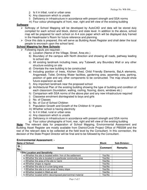
j) Is it in tribal, rural or urban area<br />
k) Any classroom which is unsafe<br />
l) Deficiency in infrastructure in accordance with present strength and SSA norms<br />
m) Four colour photographs of front, rear, right and left view of the existing building<br />
Software:<br />
Softcopy of School Mapping will be developed by AutoCAD and data will be stored duly<br />
compiled for each school and block, district and state level. In addition to the above, school<br />
map will be prepared for each school on A-4 size paper which will be displayed duly framed<br />
in the Headmaster’s Room for future reference and planning.<br />
Once this data is prepared, this will serve as Building Asset Register and shall deter the local<br />
people to encroach upon the school land.<br />
School Mapping for New Schools:<br />
Following inputs are required: -<br />
a) Location (Name of the Village, Street, Area etc.)<br />
b) Boundary of the campus with North direction and showing all roads, pathway leading<br />
to school site<br />
c) All existing landmark including trees, any Tubewell, any Boundary Wall or any other<br />
structure existing on site<br />
d) Orientate the new building to be constructed<br />
e) Including position of trees, Kitchen Shed, Child Friendly Elements, BaLA elements,<br />
Anganwadi, Toilet, Drinking Water facilities, gardening area, assembly area, parking,<br />
position of gate and any other components to be constructed. The map should show<br />
future expansion as well.<br />
f) Any important landmark near the proposed school<br />
g) Architectural Plan of the existing building showing the type of building and condition of<br />
each classroom (foundation, walling, roofing, flooring, doors, windows etc.)<br />
h) Comparison with SSA norms of the above plan and any new infrastructure required<br />
i) Classwise enrolment disintegrated to boys and girls<br />
j) No. of Classes<br />
k) No. of Out of School Children<br />
l) Population Growth and Growth of the Children 6-14 years<br />
m) Whether school is having electricity<br />
n) Is it in tribal, rural or urban area<br />
o) Any classroom which is unsafe<br />
p) Deficiency in infrastructure in accordance with present strength and SSA norms<br />
q) Four colour photographs of front, rear, right and left view of the existing building<br />
Note: The relevant data for preparation of School Mapping, Environmental Assessment and<br />
Building Asset Register are mostly available from District/Circle Project Office of PBSSM and the<br />
rest of the relevant data to be collected at the field level by the Consultant. In this connection, the<br />
decision of the State Project Director will be final and to be followed by the Consultant.<br />
Environmental Assessment: -<br />
Name of School: Block: Sub-Division:<br />
Sl.<br />
No.<br />
Issue Comment Remarks<br />
1 Site Location and Sensitivity<br />
a) Whether the site is located within 1km of the settlement Yes/No<br />
b) Whether the site is located in a particular community area Yes/No<br />
c) Whether the area of the site is 1acre Yes/No<br />
d) Whether shape is regular Yes/No<br />
e) Whether the site is in a low lying area Yes/No<br />
f) Whether the site is in an area of heavy slope Yes/No<br />
g) Whether located in filled-up soil Yes/No<br />
h) Whether located within decomposed plant/animal material Yes/No<br />
Page 2 of 2