North Coast Line South Information Pack - Queensland Rail
North Coast Line South Information Pack - Queensland Rail
North Coast Line South Information Pack - Queensland Rail

Create successful ePaper yourself
Turn your PDF publications into a flip-book with our unique Google optimized e-Paper software.
INFORMATION PACK<br />
NORTH COAST<br />
LINE SYSTEM<br />
SOUTH<br />
Nambour to Gladstone<br />
Rocklands to Rockhampton
Issue 2 - JUNE 2007<br />
Issue 1 - JULY 2003<br />
Draft 1 - AUGUST 2002<br />
NORTH COAST LINE SYSTEM - SOUTH - INFORMATION PACK<br />
(Nambour - Gladstone and Rocklands to Rockhampton)<br />
ISSUE 2 - JUNE 2007 -
T<br />
a<br />
b l e o f C o n t e n t s<br />
INTRODUCTION 5<br />
GENERAL INFORMATION 6<br />
GENERAL CLIMATE 7<br />
Cyclones 7<br />
Humidity 9<br />
Rainfall 9<br />
Temperatures 9<br />
DESCRIPTION OF THE RAILWAY 9<br />
Axle Loadings 10<br />
Basic Track Configuration 10<br />
Nambour to Bundaberg 10<br />
Bundaberg to Gladstone 11<br />
Rocklands to Rockhampton 13<br />
DESCRIPTION OF THE TRACK 14<br />
OVERHEAD LINE EQUIPMENT 15<br />
OPERATIONAL CONSTRAINTS - INFRASTRUCTURE 16<br />
TRACKSIDE DETECTION EQUIPMENT 16<br />
WEIGHBRIDGES 16<br />
INFORMATION SYSTEMS 16<br />
OPERATIONAL SYSTEMS & TRAIN CONTROL 17<br />
OPERATIONAL CONSTRAINTS - ROLLINGSTOCK 17<br />
COMMUNICATIONS 18<br />
SECTIONAL RUNNING TIMES 18<br />
INCIDENT RECOVERY TIME and MANAGEMENT 19<br />
RAIL / ROAD INTERFACES 19<br />
RAIL OPERATIONS and THE ENVIRONMENT 20<br />
NORTH COAST LINE SYSTEM - SOUTH - INFORMATION PACK<br />
(Nambour - Gladstone and Rocklands to Rockhampton)<br />
ISSUE 2 - JUNE 2007 -
MAXIMUM TRAIN LENGTH 22<br />
ROLLINGSTOCK BRAKING RATE 23<br />
FUTURE INFRASTRUCTURE IMPROVEMENTS 23<br />
INFRASTRUCTURE MANAGEMENT and ACCESS 23<br />
APPENDIX A 24<br />
Definitions (Statewide) 24<br />
APPENDIX B 30<br />
Schematic Layouts 30<br />
APPENDIX C 37<br />
<strong>Rail</strong> / Road Interface Details 37<br />
APPENDIX D 41<br />
Speed Boards 41<br />
APPENDIX E 48<br />
Track Data & Grade Diagrams 48<br />
APPENDIX F 72<br />
Sectional Running Times 72<br />
APPENDIX G 74<br />
Altitudes 74<br />
APPENDIX H 75<br />
Rollingstock Gauges 75<br />
APPENDIX I 79<br />
Trackside Detection Equipment 79<br />
INDEX 80<br />
NORTH COAST LINE SYSTEM - SOUTH - INFORMATION PACK<br />
(Nambour - Gladstone and Rocklands to Rockhampton)<br />
ISSUE 2 - JUNE 2007 -
INTRODUCTION<br />
This information pack has been published by Network Access Group of <strong>Queensland</strong> <strong>Rail</strong><br />
(QR). Network Access was established to control the essential fixed rail infrastructure<br />
and be responsible for managing access by railway operators. This pack is to provide<br />
potential railway operators with background infrastructure and operational information<br />
for the <strong>North</strong> <strong>Coast</strong> <strong>Line</strong> System in <strong>South</strong>ern <strong>Queensland</strong>.<br />
The detail provided in this pack relates to infrastructure and operational information<br />
necessary to develop a conceptual operating plan. It is envisaged that railway operators<br />
will liaise closely with Network Access to formulate a detailed operating specification<br />
as part of a full access agreement negotiation. Operational parameters outlined in this<br />
pack may be varied by mutual agreement with Network Access.<br />
Network Access will manage contracts for infrastructure maintenance and ensure it<br />
is planned well in advance to effectively manage and minimise service disruptions.<br />
Network Access will regularly monitor the capacity of the rail system to cater for any<br />
growth in traffic.<br />
All railway operators, wishing to operate in <strong>Queensland</strong>, require Accreditation under<br />
the Transport Infrastructure Act 1994 (Qld) and need to consider, but not limited to, the<br />
following aspects of typical rail operations:-<br />
• Provisioning, stabling or stowing areas for rollingstock<br />
• Train crewing<br />
• Safeworking<br />
• Training<br />
• Route knowledge<br />
• Environmental requirements<br />
• Track standards<br />
• Signalling and traction systems standards and constraints<br />
• Safety training<br />
• Management of risk<br />
• Rollingstock registration and Train authorisation<br />
• Legal issues as contained in QR’s Access Undertaking, Access<br />
Agreements and information contained in this pack.<br />
Operators will be required to have <strong>Queensland</strong> Transport accreditation, hold an Access<br />
Agreement with Network Access and to meet any conditions and precedents specified<br />
in the Access Agreement prior to commencing operations. The Accreditation process<br />
requires applicants to demonstrate competence and capability to safely commence<br />
rail operations. The Accreditation process is managed by <strong>Queensland</strong> Transport,<br />
which is independent of Network Access. Contact details are The Manager, <strong>Rail</strong> Safety<br />
Accreditation, Land Transport and Safety Division, <strong>Queensland</strong> Transport, Transport<br />
House, 230 Brunswick Street, Fortitude Valley 4006.<br />
Operators need to be aware of and comply with other general legislation such as<br />
but not limited to Workplace Health & Safety, Environmental legislation and Heritage<br />
legislation.<br />
This package is issued to railway operators as an UNCONTROLLED DOCUMENT and<br />
is reviewed annually. It is the onus of railway operators to ensure they are using the<br />
current version of this document.<br />
NORTH COAST LINE SYSTEM - SOUTH - INFORMATION PACK<br />
(Nambour - Gladstone and Rocklands to Rockhampton)<br />
ISSUE 2 - JUNE 2007 -
This <strong>Information</strong> <strong>Pack</strong> is provided for information purposes only and QR<br />
does not make any representation or warranty, express or implied, as to the<br />
accuracy, suitability or completeness of the information. To the extent that any<br />
inconsistency arises between this <strong>Information</strong> <strong>Pack</strong> and the Access Agreement<br />
or QR’s Access Undertaking, the provisions of the Access Agreement and QR’s<br />
Access Undertaking shall prevail.<br />
GENERAL INFORMATION<br />
The <strong>North</strong> <strong>Coast</strong> <strong>Line</strong> System is located the length of <strong>Coast</strong>al <strong>Queensland</strong> between<br />
Cairns ( 16°55’ S - 145°46’ E) in the north and Brisbane ( 27°27’ S - 153°01’ E) in<br />
the south, a distance of 1681 km. Due to the length of this System there will be<br />
two information packs, <strong>South</strong> - Nambour to Rockhampton (excluding Gladstone to<br />
Rocklands) and <strong>North</strong> - Rockhampton to Cairns.<br />
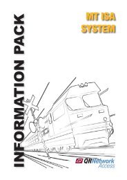
MT<br />
ISA<br />
ROCKHAMPTON 638.790<br />
Rocklands 632.970<br />
Midgee 624.300 Archer 615.220<br />
Marmor 597.140<br />
Bajool 605.420 Raglan 585.110<br />
Mt Larcom 565.260<br />
Epala 576.890<br />
Callemondah 534.300<br />
Yarwun 547.760 Gladstone 529.000<br />
Parana 524.910<br />
Single Track<br />
Benaraby 506.950<br />
2 Tracks<br />
Iveragh 486.270<br />
NORMANTON<br />
CLONCURRY<br />
CROYDON<br />
FORSAYTH<br />
PHOSPHATE HILL<br />
WINTON<br />
Bororen 471.890<br />
Miriam Vale 460.00<br />
UP Direction<br />
Netley 447.020<br />
Irkanda 435.100<br />
Baffle 424.740<br />
Berajondo 413.250<br />
Flinders 401.070 Littabella 384.580<br />
MUNGANA<br />
HUGHENDEN<br />
LONGREACH<br />
QUILPIE<br />
YARAKA<br />
CAIRNS<br />
TOWNSVILLE<br />
NEWLANDS<br />
MINE<br />
RIVERSIDE<br />
MALLAWA<br />
BLAIR<br />
ATHOL<br />
JERICHO EMERALD<br />
SPRINGSURE<br />
CHARLEVILLE<br />
BOWEN<br />
COPPABELLA<br />
TOLMIES<br />
MOURA<br />
THEODORE<br />
ROMA<br />
GLENMORGAN<br />
Avondale 375.270 Meadowvale 360.390<br />
Gooburrum 355.110 <strong>North</strong> Bundaberg 352.450<br />
Bundaberg 351.170<br />
Thabeban 348.340<br />
Elliott 338.520<br />
Kinkuna 329.870<br />
Goodwood 319.470<br />
Isis Jct. 310.020<br />
Wokka 302.140<br />
Howard 292.880<br />
Torbanlea 288.150<br />
Colton 277.970<br />
Maryborough West 262.820<br />
Maryborough<br />
Yengarie 256.290<br />
Mungar 250.500<br />
MACKAY<br />
MONTO<br />
MILES<br />
CUNNAMULLA<br />
MILLMERRAN<br />
THALLON<br />
DIRRANBANDI<br />
GOONDIWINDI<br />
ROCKHAMPTON<br />
GLADSTONE<br />
DALBY<br />
TOOWOOMBA<br />
WARWICK<br />
Banks Pocket 174.930<br />
BUNDABERG<br />
GYMPIE<br />
WALLANGARRA<br />
MARYBOROUGH<br />
CABOOLTURE<br />
BRISBANE<br />
UP Direction<br />
Single Track<br />
2 Tracks<br />
3 Tracks<br />
4 Tracks<br />
Tiaro 235.820<br />
Gundiah 221.390<br />
Theebine 207.490<br />
Gympie <strong>North</strong> 173.650<br />
Glanmire 168.140<br />
Cooroy 130.990<br />
Nambour 104.840<br />
Landsborough 82.510<br />
Caboolture 50.390<br />
Lawnton 26.890<br />
<strong>North</strong>gate 10.900<br />
ROMA STREET<br />
NORTH COAST LINE SYSTEM - SOUTH - INFORMATION PACK<br />
(Nambour - Gladstone and Rocklands to Rockhampton)<br />
ISSUE 2 - JUNE 2007 -
The <strong>North</strong> <strong>Coast</strong> <strong>Line</strong> System (<strong>South</strong>) incorporates two other systems, the Blackwater<br />
System (between Rocklands and Gladstone) and the Brisbane Metropolitan System<br />
(between Roma Street and Nambour). The Maryborough System straddles the <strong>North</strong><br />
<strong>Coast</strong> System and picks all branch lines in that vicinity.<br />
The scope of this <strong>Information</strong> <strong>Pack</strong> will cover Nambour to Gladstone, Rocklands to<br />
Rockhampton and branch lines.<br />
The system, overall, caters for all traffic tasks from heavy haul block trains to high speed<br />
tilt train and commuter services.<br />
This single line section of track (425 km in length) provides the strategic link between<br />
<strong>North</strong> and <strong>South</strong> and sees an annual tonnage in excess of 8 million tonnes hauled over<br />
the corridor.<br />
The entire length between Roma Street and Rockhampton is electrified with the section<br />
Caboolture to Rocklands electrified by an autotransformer system with the overhead line<br />
equipment operating at 25,000 volts, 50 Hertz, alternating supply (25 kV, 50 Hz, ac).<br />
The section Caboolture to Roma Street is electrified by a booster transformer system<br />
energised with 25 kV AC (alternating current) power.<br />
Included in the System are Branch <strong>Line</strong>s that have been catergorised as “Non-<strong>Rail</strong><br />
and Non-Operational Corridor Land” and will not be considered further, namely Bunda<br />
Street Branch (Bundaberg) and Colton to Takura.<br />
Descriptive distances within this document (unless otherwise stated) are based on<br />
physical kilometre posts in the field and are to be used only as location descriptors<br />
ie they do not compensate for equalities resulting from deviations. Access charges<br />
and performance statistics are generated using actual through distances derived from<br />
relevant Working Plan and Sections and reflected on <strong>Line</strong> Code Diagrams. Generally<br />
distances originate from the junction of the branch and commence at 0 km.<br />
GENERAL CLIMATE<br />
The system is generally in a warm to hot temperature climate.<br />
The following sub-sections specify general climatic parameters. For latest and more<br />
specific information potential railway operators should consult The Australian Bureau<br />
of Meteorology at it’s Internet Website:<br />
Cyclones<br />
http://www.bom.gov.au/climate<br />
Tropical lows, which develop from November to April, occasionally deepen to cause<br />
tropical cyclones. Tropical cyclones show great variation in behaviour. They foster high<br />
winds, heavy, flood-producing rainfall (especially when a cyclone moves over high<br />
ground), and coastal storm surges.<br />
The high wind risk does not usually extend further inland than 50 km. Inland movement<br />
reduces the inflow of moisture and cyclone intensity declines, often within a few<br />
hours.<br />
NORTH COAST LINE SYSTEM - SOUTH - INFORMATION PACK<br />
(Nambour - Gladstone and Rocklands to Rockhampton)<br />
ISSUE 2 - JUNE 2007 -
Average Annual<br />
Rainfall<br />
Millimetres<br />
Cairns<br />
3200<br />
2400<br />
1800<br />
Mt Isa<br />
Hughenden<br />
Townsville<br />
Merinda<br />
Mackay<br />
1200<br />
800<br />
600<br />
Winton<br />
400<br />
Longreach<br />
Rockhampton<br />
Gladstone<br />
300<br />
200<br />
100<br />
Quilpie<br />
Roma<br />
50<br />
Cunnamulla<br />
Dirranbandi<br />
Toowoomba<br />
Brisbane<br />
Based on a standard 30 - year climatology (1961 to 1990)<br />
Source : Bureau of Meteorology<br />
NORTH COAST LINE SYSTEM - SOUTH - INFORMATION PACK<br />
(Nambour - Gladstone and Rocklands to Rockhampton)<br />
ISSUE 2 - JUNE 2007 -
Cyclones may impact on this System, generally to a lesser extent than the tropics north<br />
of Rockhampton.<br />
Not all cyclones are severe.<br />
Humidity<br />
This region could experience prolonged periods of high humidity and potential railway<br />
operators should consider this when planning / designing rollingstock and machinery<br />
to operate on this rail system.<br />
Rainfall<br />
The wettest places in <strong>Queensland</strong> are located on the tropical coast between Innisfail<br />
and Cairns.<br />
Highest rainfall occurs on the seaward side of the Great Divide.<br />
However, at times in summer the inland extension of low-level moist airflow, in<br />
combination with intense surface heating, produces significant thunderstorm activity.<br />
Rainfall is mostly confined to summer months in the northern tropics, where in excess<br />
of 90% of the annual total is recorded between November and April.<br />
In the north, rain is mostly associated with monsoonal troughs.<br />
The wet season in <strong>Queensland</strong> is predominantly from January to April when monthly<br />
rain falls of 400 mm or more can occur.<br />
Flooding of low lying areas is likely to occur as a direct result of cyclones and heavy<br />
coastal rains. In these instances, floodwaters can affect this System on average closing<br />
the line for one day every year.<br />
Temperatures<br />
The average annual values of the daytime maximum of the hottest (January) and nighttime<br />
minimum of the coldest (July) months are indicated on the climatic maps.<br />
During the period of peak temperature, it may be an operational requirement that <strong>Line</strong><br />
Speed be reduced to minimise the risk of incident (refer Operational Constraints).<br />
DESCRIPTION OF THE RAILWAY<br />
The track (1067 mm gauge) on the <strong>North</strong> <strong>Coast</strong> System main line is a mix of nominal<br />
41, 47, 50, 53 and 60 kg/m rail on timber, steel and concrete sleepers.<br />
<strong>Information</strong> on track, rollingstock, train operations, container operations and special train<br />
operations for the safe operation of trains on this System are contained in STD/0071/<br />
SWK - Operational Route Manual, issued by the Chief Risk Officer.<br />
NORTH COAST LINE SYSTEM - SOUTH - INFORMATION PACK<br />
(Nambour - Gladstone and Rocklands to Rockhampton)<br />
ISSUE 2 - JUNE 2007 -
Axle Loadings<br />
Maximum axle loads used throughout this document have been determined by either the<br />
track configuration or the railway structures below rail. <strong>Rail</strong>way structures were designed<br />
for axle loads, axle spacings and vehicle lengths that produce bending moments roughly<br />
equivalent to the moments for metric Cooper’s loadings as follows :-<br />
Maximum axle load<br />
Metric Cooper’s Loading<br />
26 tal M 220<br />
20 tal M 160<br />
15.75 tal M 130<br />
For rollingstock of different configuration, e.g. in respect of axle spacing and vehicle<br />
lengths, lesser axle loads and/or speed restrictions may be required before rollingstock<br />
may be authorised to operate.<br />
Basic Track Configuration<br />
Basic track configuration is detailed on APPENDIX B - SCHEMATIC LAYOUTS.<br />
Nambour to Bundaberg<br />
Nambour (elevation 16 m) defines the northern extent of the Metropolitan System. From<br />
Nambour the <strong>North</strong> <strong>Coast</strong> <strong>Line</strong> heads north along the coastal plain to Cooroy (elevation<br />
110 m), north west to Theebine (elevation 61 m and junction for the Kingaroy Branch),<br />
north to Mungar (elevation 22 m and junction for the Monto Branch), continuing on<br />
through Maryborough West (junction for Maryborough Branch), Colton (elevation 39<br />
m and junction for the Takura Branch) before heading north north west to Bundaberg<br />
(elevation 11 m).<br />
There are thirty-one passing loops on this section namely Yandina, <strong>North</strong> Arm, Sunrise,<br />
Cooroy, Pomona, Cooran, Traveston, Woondum, Glanmire, Gympie <strong>North</strong>, Tamaree,<br />
Harvey’s Siding, Curra, Theebine, Paterson, Gundiah, Netherby, Tiaro, Owanyilla,<br />
Mungar, Yengarie, Maryborough West, Colton, Torbanlea, Howard, Wokka, Isis Junction,<br />
Goodwood, Kinkuna, Elliott and Bundaberg.<br />
Track structure is a mix of nominal 47, 50, 53 and 60 kg/m rail on steel and concrete<br />
sleepers.<br />
The maximum allowable axle load is 20 tal.<br />
The maximum allowable speed for locomotive hauled stock is 100 km/h, Intercity Express<br />
trains is 120 km/h and Tilt trains 160 km/h.<br />
The maximum grade (not compensated for horizontal alignment) that a northbound<br />
(Down) train will encounter is 1 in 44 near Gundiah whilst for an southbound (Up) train<br />
the maximum grade is 1 in 44 near Theebine.<br />
Existing minimum nominal horizontal curve radii are as follows :-<br />
running line<br />
161 m<br />
NORTH COAST LINE SYSTEM - SOUTH - INFORMATION PACK<br />
(Nambour - Gladstone and Rocklands to Rockhampton)<br />
ISSUE 2 - JUNE 2007 - 10
Fencing along this corridor complements adjacent land usage and is at the following<br />
standard, poor (25 %) and good (75 %). Fencing will be maintained at its current<br />
standard.<br />
Corridor<br />
Nambour to<br />
Bundaberg<br />
<strong>Line</strong> Section Code NC 401, 724, 725, 726, 727, 728, 729, 105, 446, 419, 122<br />
System<br />
No. of Tracks<br />
Route Km<br />
Track Km<br />
Electrified<br />
Safeworking System<br />
Control Centre<br />
Crossing Loops<br />
<strong>North</strong> <strong>Coast</strong><br />
1<br />
233.97<br />
233.97<br />
Yes<br />
RCS<br />
5th Floor RC1<br />
No. 31<br />
Location and length<br />
Yandina (723pp), <strong>North</strong> Arm (710pp), Sunrise (857pp), Cooroy<br />
(905pp), Pomona (682pp), Cooran (921pp), Traveston (804pp),<br />
Woodum (734pp), Glanmire (700pp), Gympie <strong>North</strong> (681pp),<br />
Tamaree (756pp), Harvey's Siding (862pp), Curra (733pp),<br />
Theebine (697pp), Paterson (694pp), Gundiah (878pp), Netherby<br />
(706pp), Tiaro - Loop (471pp), Tiaro - Main (532pp), Owanyilla<br />
(715pp), Mungar - Loop (726pp), Mungar - Main (647pp), Yengarie<br />
(596pp), Maryborough West (700pp), Colton - Loop (723pp),<br />
Colton - Main (691pp), Torbanlea (699pp), Howard (712pp), Wokka<br />
(694pp), Isis Jct (711pp), Goodwood (704pp), Kinkuna (754pp),<br />
Elliott (723pp), Bundaberg Main & Loop (1305pp)<br />
Bridges (no of spans.)/Length<br />
(m)<br />
Overbridges (No. of Bridges)<br />
Tunnels (no.)/<br />
Curves (% of total track)<br />
Timber<br />
No. of Bridges 11<br />
No. of Spans 119<br />
Length (m) 782.4<br />
Steel<br />
No. of Bridges 7<br />
No. of Spans 55<br />
Length (m) 786.6<br />
Concrete<br />
No. of Bridges 47<br />
No. of Spans 194<br />
Length (m) 3011.6<br />
Timber 7<br />
Steel 0<br />
Concrete 12<br />
Length (m)<br />
Number 1<br />
Length (m) 175<br />
Track structure is a mix of nominal 47, 50, 53 and 60 kg/m rail on timber, concrete and<br />
steel sleepers.<br />
The maximum allowable axle load is 20 tal.<br />
The maximum allowable speed for locomotive hauled stock is 100 km/h, Intercity Express<br />
trains is 120 km/h and Tilt trains 160 km/h.<br />
The maximum grade (not compensated for horizontal alignment) that a southbound<br />
(Up) train will encounter is 1 in 50 whilst for an northbound (Down) train the maximum<br />
grade is 1 in 50, both at a number of locations along the route.<br />
Existing minimum nominal horizontal curve radii are as follows :-<br />
running line<br />
160 m<br />
Fencing along this corridor complements adjacent land usage and is at the following<br />
standard, poor (25 %) and good (75 %). Fencing will be maintained at its current<br />
standard.<br />
Corridor<br />
Bundaberg to<br />
Parana to<br />
Parana<br />
Gladstone Station<br />
<strong>Line</strong> Section Code NC 730, 733, 592 NC 751<br />
System<br />
<strong>North</strong> <strong>Coast</strong><br />
Blackwater<br />
No. of Tracks<br />
1 1<br />
Route Km<br />
171.605 4.359<br />
Track Km<br />
171.605 4.359<br />
Electrified Yes Yes<br />
Safeworking System<br />
RCS<br />
RCS<br />
Control Centre<br />
5th Floor RC1<br />
Rockhampton<br />
Crossing Loops<br />
No. 14 0<br />
Location and length<br />
<strong>North</strong> Bundaberg (512pp),<br />
Meadowvale - Main (708pp),<br />
Meadowvale Loop (708pp),<br />
Avondale (701pp), Littabella<br />
(698pp), Flinders Loop (823pp),<br />
Flinders Main (795pp), Berajondo<br />
(744pp), Baffle (824pp), Irkanda<br />
(734pp), Netley (716pp), Miriam<br />
Vale (695pp), Bororen (724pp),<br />
Iveragh (903pp), Bernaraby<br />
(698pp), Parana (908pp)<br />
-<br />
Bridges (no of spans.)/Length<br />
(m)<br />
Overbridges (No. of Bridges)<br />
Tunnels (no.)/<br />
Curves (% of total track)<br />
Timber<br />
No. of Bridges 9 0<br />
No. of Spans 116 0<br />
Length (m) 744.8 0<br />
Steel<br />
No. of Bridges 9 0<br />
No. of Spans 105 0<br />
Length (m) 1505.4 0<br />
Concrete<br />
No. of Bridges 31 0<br />
No. of Spans 105 0<br />
Length (m) 1664.3 0<br />
Timber 2 0<br />
Steel 0 0<br />
Concrete 2 0<br />
Length (m)<br />
Number 0 0<br />
Length (m) 0 0<br />
Rocklands to Rockhampton<br />
The <strong>North</strong> <strong>Coast</strong> <strong>Line</strong> System and the Blackwater System diverge at Rocklands,<br />
with the Blackwater System to the west and the <strong>North</strong> <strong>Coast</strong> <strong>Line</strong> System continuing<br />
north across the Yeppen flood plain, through Port Curtis Junction (elevation 6 m) to<br />
Rockhampton (elevation 8 m).<br />
Track structure is 41 and 60 kg/m rail on timber and concrete sleepers.<br />
The maximum allowable axle load is 20 tal.<br />
Corridor<br />
Rocklands to<br />
Rockhampton<br />
<strong>Line</strong> Section Code NC 402<br />
System<br />
No. of Tracks<br />
Route Km<br />
Track Km<br />
Electrified<br />
Safeworking System<br />
Control Centre<br />
Crossing Loops<br />
<strong>North</strong> <strong>Coast</strong><br />
1<br />
9.197<br />
9.197<br />
Yes<br />
RCS<br />
Rockhampton<br />
No. 0<br />
Location and length -<br />
Bridges (no of spans.)/Length<br />
(m)<br />
Overbridges (No. of Bridges)<br />
Tunnels (no.)/<br />
Curves (% of total track)<br />
Timber<br />
No. of Bridges 0<br />
No. of Spans 0<br />
Length (m) 0<br />
Steel<br />
No. of Bridges 0<br />
No. of Spans 0<br />
Length (m) 0<br />
Concrete<br />
No. of Bridges 4<br />
No. of Spans 44<br />
Length (m) 440<br />
Timber 0<br />
Steel 0<br />
Concrete 0<br />
Length (m)<br />
Number 0<br />
Length (m) 0<br />
The maximum grade(not compensated for horizontal alignment) that a southbound<br />
(Up) train will encounter is 1 in 140 whilst for an northbound (Down) train the maximum<br />
grade is 1 in 140.<br />
Existing minimum nominal horizontal curve radii are as follows :-<br />
running line<br />
480 m<br />
Fencing along this corridor complements adjacent land usage and is at the following<br />
standard, poor (25 %) and good (75 %). Fencing will be maintained at its current<br />
standard.<br />
Horizontal radius for new or upgrade works on this System is as follows :-<br />
running line 2170 m 160 km/h running<br />
1910 m 150 km/h running<br />
1662 m 140 km/h running<br />
1432 m 130 km/h running<br />
1221 m 120 km/h running<br />
1026 m 110 km/h running<br />
848 m 100 km/h running<br />
687 m 90 km/h running<br />
542 m 80 km/h running<br />
balloon loop 300 m minimum radius<br />
siding and depot<br />
140 m<br />
DESCRIPTION OF THE TRACK<br />
The track on this system is a mix of 60 kg/m, 53 kg/m, 50 kg/m, 47 kg/m and 41 kg/m<br />
rail and timber, steel and concrete sleepers on crushed rock ballast. The rails are<br />
continuously welded (CWR).<br />
Speeds through the curved leg of turnouts are governed by the angle of that turnout<br />
ie.<br />
1 in 12 25 km/h<br />
1 in 16 50 km/h<br />
1 in 25 80 km/h<br />
In general, curves (with the exception of turnout curves) are transitioned.<br />
Preliminary Track Data and Grade Diagrams for the following major route are included<br />
in Appendix E.<br />
NORTH COAST LINE SYSTEM - SOUTH - INFORMATION PACK<br />
(Nambour - Gladstone and Rocklands to Rockhampton)<br />
ISSUE 2 - JUNE 2007 - 14
Nambour - Gladstone (SUR 442 Sheets 3 to 24)<br />
Rocklands - Rockhampton (SUR 442 Sheet 29)<br />
Working Plan and Section drawings are available on the CD version of this <strong>Information</strong><br />
<strong>Pack</strong>. These drawings are issued and accepted for use by potential railway operators<br />
subject to the following:<br />
“QR does not warrant the fitness for purpose or accuracy of this information”<br />
OVERHEAD LINE EQUIPMENT<br />
The <strong>North</strong> <strong>Coast</strong> <strong>Line</strong> System<br />
b e t w e e n N a m b o u r a n d<br />
Rockhampton is electrified by<br />
an autotransformer system with<br />
the overhead line equipment<br />
operating at 25 000 volts, 50 Hertz,<br />
alternating supply (25 kV, 50 Hz,<br />
ac). Distribution is via a contact<br />
wire suspended from a catenary<br />
wire and these two wires are held<br />
in place by supporting structures to<br />
maintain ideal pantograph/contact<br />
wire interaction.<br />
Typically, the autotransformer<br />
system also uses a 25 kV AC<br />
feeder wire run on the back of the<br />
supporting structure which is used<br />
for voltage support throughout the<br />
electrified network.<br />
The dual wire distribution system is<br />
automatically tensioned to maintain a constant wire tension and requires a pantograph<br />
uplift force of 80 N ± 10 N for smooth sparkless current collection.<br />
Typically on the <strong>North</strong> <strong>Coast</strong> <strong>Line</strong>, the traction system uses both rails for return<br />
current.<br />
NORTH COAST LINE SYSTEM - SOUTH - INFORMATION PACK<br />
(Nambour - Gladstone and Rocklands to Rockhampton)<br />
ISSUE 2 - JUNE 2007 - 15
OPERATIONAL CONSTRAINTS - INFRASTRUCTURE<br />
During the summer months of high temperatures, hot weather precautions for track<br />
stability are observed to reduce the risk of incident in accordance with Safety<br />
Management Standard STD/0075/TEC Hot Weather Precautions for Track Stability,<br />
namely :-<br />
Air Temperature 38°C and above - On timber sleepered track, restrict<br />
all trains to 60 km/h (#)<br />
- On concrete sleepered track, restrict<br />
all trains to 120 km/h<br />
Air Temperature 40°C and above - On timber sleepered track, restrict<br />
all trains to 40 km/h (#)<br />
- On concrete sleepered track, restrict<br />
all trains to 60 km/h<br />
(#) Steel sleepered track and timber sleepered track with interspersed steel sleepers<br />
shall be regarded as equivalent to timber sleepered track for track stability.<br />
Speed restrictions may also be put in place after maintenance activities in accordance<br />
with QR Safety Standards.<br />
The extent of restriction will depend upon the type of maintenance activity and risk of<br />
track misalignments.<br />
Force Majeure Events will also see the imposition of speed restrictions, the extent and<br />
severity of the restrictions being dependent on the event.<br />
TRACKSIDE DETECTION EQUIPMENT<br />
Trackside detection equipment is installed on this system to protect below rail<br />
infrastructure and rollingstock from incident.<br />
A summary of locations / equipment type / reporting functions can be found in Appendix<br />
I<br />
WEIGHBRIDGES<br />
There are no weighbridges on this System as described herein.<br />
INFORMATION SYSTEMS<br />
Vizi<strong>Rail</strong> is the key software system designed as a tool for use in integrated scheduling,<br />
possession planning, monitoring and reporting on the QR network.<br />
Functionality includes modules:<br />
Train notices<br />
Actual train running (ATR)<br />
NORTH COAST LINE SYSTEM - SOUTH - INFORMATION PACK<br />
(Nambour - Gladstone and Rocklands to Rockhampton)<br />
ISSUE 2 - JUNE 2007 - 16
Incidents<br />
Train consists (Train Builder)<br />
Speed restrictions<br />
Rollingstock allocations<br />
Rollingstock maintenance<br />
Fresh turnouts<br />
Planning graphs<br />
Scheduling enhancements<br />
Possession enhancements<br />
OTIS (Operational to <strong>Information</strong> Systems) - which converts train steps to<br />
actual arrival and departure train information.<br />
OPERATIONAL SYSTEMS & TRAIN CONTROL<br />
The <strong>North</strong> <strong>Coast</strong> <strong>Line</strong> System is operated by Remote Control Signalling (RCS), Automatic<br />
Train Control (ATC) and Automatic Train Protection (ATP).<br />
Train Control for the <strong>North</strong> <strong>Coast</strong> <strong>Line</strong>, from Nambour to Parana is located in Brisbane<br />
whilst Train Control for Parana to Rockhampton is located in Rockhampton<br />
OPERATIONAL CONSTRAINTS - ROLLINGSTOCK<br />
All new rollingstock requires to be accepted via the Rollingstock Authorisation Process,<br />
rollingstock which conforms with Drawing Nos. 2236, 2237 and 2238 may operate in<br />
an unrestricted manner on main lines.<br />
NORTH COAST LINE SYSTEM - SOUTH - INFORMATION PACK<br />
(Nambour - Gladstone and Rocklands to Rockhampton)<br />
ISSUE 2 - JUNE 2007 - 17
For rollingstock to conform with Drawing Nos. 2236, 2237 and 2238 the static rollingstock<br />
profile must be within the diagram, refer APPENDIX H - Rollingstock Gauges. As well<br />
as the static component, dynamic effects need to be considered and these effects are<br />
contained within Rollingstock Interface Standards.<br />
Rollingstock not conforming to these drawings may be accepted via the Rollingstock<br />
Authorisation Process and may be operated subject to constraints / limitations imposed<br />
as a result of the Authorisation Process.<br />
Potential railway operators should ensure that they have the latest revision of these<br />
drawings before the planning and construction of rollingstock.<br />
COMMUNICATIONS<br />
Communications on the Moura System between Driver and Controller is via a UHF radio<br />
system (Train Control Radio - TCR) utilising a number of QR channels and frequencies.<br />
Tranceivers “auto” switch channels to suit geographical location. Frequency specification<br />
and coverage details are available as part of the “Access Enquiry Process”. Control<br />
phones are located at Staff Stations only.<br />
Access to the Maintenance Supervisory Radio System (MSR) can be gained by using<br />
QR telephone extensions depending on location or UHF radio system utilising QR<br />
channels.<br />
In addition, all current locomotives (including Multiple Units and Miscellaneous Vehicles<br />
such as <strong>Rail</strong> Motors) carry and all units new to the system will be required to carry a UHF<br />
radio operating on QR Channel 1. This provides on-board and wayside communications<br />
including end to end, train to train and train to track gangs over a distance on average<br />
of 8 - 10 km.<br />
Communications on board locomotives must conform to QR’s Safety and Security<br />
Standard SAF/STD/0014/TEL - Mobile Voice Radio Communications Systems.<br />
SECTIONAL RUNNING TIMES<br />
The sectional running times, expressed as minutes, for the various types of trains<br />
currently operating on the system are contained in APPENDIX F.<br />
The sectional running times are “Pass to Pass” times for a running move and therefore<br />
do not reflect the acceleration and deceleration characteristics of trains.<br />
In accordance with QR’s 2005 Access Undertaking the sectional running times are<br />
required to reflect a ‘predominant train’ being a train which, at 1 July 2005, was projected<br />
to utilise more train paths than any other train on the corridor. For completeness,<br />
sectional running times are provided for two (2) types of locomotive-hauled trains -<br />
passenger and container (inter-modal).<br />
Proposed train configurations would need to be confirmed by the relevant operator<br />
against the infrastructure constraints to determine if the sectional running times can be<br />
achieved. If the sectional running times cannot be achieved then different arrangements,<br />
including for access charges, may need to be negotiated as part of the access agreement<br />
negotiations.<br />
NORTH COAST LINE SYSTEM - SOUTH - INFORMATION PACK<br />
(Nambour - Gladstone and Rocklands to Rockhampton)<br />
ISSUE 2 - JUNE 2007 - 18
Changes to the sectional running times for the system are also possible over time. Any<br />
changes would be confirmed as part of the access agreement negotiations.<br />
Trains travelling south to Brisbane are travelling in the Up Direction whilst trains travelling<br />
north to Cairns are travelling in the Down Direction.<br />
INCIDENT RECOVERY TIME and MANAGEMENT<br />
Historically it is anticipated that on the <strong>North</strong> <strong>Coast</strong> <strong>Line</strong> System a minor incident could<br />
result in disruption to services for 6 hours and a major incident for 2 days.<br />
Incident recovery is dependent on the nature, severity and location of each unique<br />
incident that may occur on this system.<br />
To enable quick response in case of emergency, latitudes and longitudes of some<br />
passing loops, generally direction change, are detailed below :<br />
Location Latitude Longitude<br />
Roma Street 27° 27’ S 153° 01’ E<br />
<strong>North</strong>gate 27° 23’ S 153° 04’ E<br />
Lawnton 27° 16’ S 152° 58’ E<br />
Caboolture 27° 04’ S 152° 57’ E<br />
Landsborough 26° 48’ S 152° 58’ E<br />
Nambour 26° 37’ S 152° 57’ E<br />
Cooroy 26° 25’ S 152° 54’ E<br />
Gympie <strong>North</strong> 26° 09’ S 152° 41’ E<br />
Theebine 25° 56’ S 152° 32’ E<br />
Mungar 25° 36’ S 152° 35’ E<br />
Maryborough West 25° 30’ S 152° 38’ E<br />
Colton 25° 25’ S 152° 39’ E<br />
Wokka 25° 16’ S 152° 30’ E<br />
Bundaberg 24° 52’ S 152° 20’ E<br />
Berajondo 24° 37’ S 151° 50’ E<br />
Miriam Vale 24° 19’ S 151° 33’ E<br />
Gladstone 23° 50’ S 151° 15’ E<br />
Rocklands 23° 26’ S 150° 31’ E<br />
Rockhampton 23° 23’ S 150° 30’ E<br />
RAIL / ROAD INTERFACES<br />
Operators on this section of the <strong>North</strong> <strong>Coast</strong> <strong>Line</strong> System (ie Nambour to Gladstone<br />
and Rocklands to Rockhampton) will encounter 126 <strong>Rail</strong> / Road Interfaces and 2 <strong>Rail</strong><br />
/ Tram Interfaces (see Appendix C for details) categorised as follows:-<br />
Public (Active with Flashing Light/Boom Gate Protection) - 54<br />
Public (with Passive Protection - Signs) - 10<br />
Occupation (Active with Flashing Light) - 2<br />
Occupation (Private Access - Signs) - 47<br />
Occupation (Private Access - No signs) - 13<br />
NORTH COAST LINE SYSTEM - SOUTH - INFORMATION PACK<br />
(Nambour - Gladstone and Rocklands to Rockhampton)<br />
ISSUE 2 - JUNE 2007 - 19
RAIL OPERATIONS and THE ENVIRONMENT<br />
All railway operators are required to comply with all relevant State, Federal and Local<br />
Legislation and Laws, current at the time, relating to the management and protection<br />
of the Environment.<br />
QR currently has a number of licences and/or approvals for activities undertaken at<br />
either QR facilities or on the QR corridor. QR’s licences and approvals fall under two<br />
main areas:<br />
1. Fixed Locations;<br />
QR has a number of licences for activities managed by its operational Business<br />
Groups in particular locations, such as refuelling locations.<br />
2. Itinerant or Varied Locations;<br />
QR also has a number of licences for activities that occur at more than one<br />
such as maintenance activities.<br />
location,<br />
<strong>Rail</strong>way operators will need to ascertain with the Environmental Protection Agency (EPA)<br />
or Other Regulatory Body their responsibilities in regard to obtaining an Environmental<br />
Authority(ies) for the type of operation proposed.<br />
Copies of all Environmental Authorities administered by the Environmental Protection<br />
Agency within <strong>Queensland</strong> are available upon request from the EPA. EPA contact<br />
details can be found via the Environmental Protection Agency Web site at<br />
Environmental Noise<br />
http://www.env.qld.gov.au/<br />
The Environmental Protection (Noise) Policy (EPP Noise) recognises a railway as a<br />
beneficial asset, which is necessary for the community’s environmental, social and<br />
economic well-being. The Environmental Protection (Noise) Policy is available from<br />
the Government Printers (GoPrint) or via the Office of the <strong>Queensland</strong> Parliamentary<br />
Council web site at<br />
http://www.legislation.qld.gov.au/OQPChome.htm<br />
The EPP Noise nominates “planning levels” for railway noise which may be used as a<br />
guide in deciding a reasonable noise level for the activity. The EPP Noise recognises,<br />
however, those levels may not be appropriate for an existing railway. It envisages that it<br />
may be reasonable to apply the levels only in the long term to allow time to progressively<br />
reduce any significantly adverse effects on the environmental values from its operation.<br />
The long term planning levels are:<br />
LAeq (24 hour)<br />
LAmax<br />
65dBA<br />
87dBA<br />
They are to be assessed one (1) metre in front of the most exposed part of the building<br />
facade of an affected noise sensitive place.<br />
NORTH COAST LINE SYSTEM - SOUTH - INFORMATION PACK<br />
(Nambour - Gladstone and Rocklands to Rockhampton)<br />
ISSUE 2 - JUNE 2007 - 20
Code of Practice for <strong>Rail</strong>way Noise Management<br />
Noise is recognised as a form of environmental nuisance in the Environment<br />
Protection Act. QR intends to meet its general environmental duty with respect to<br />
noise by implementing it’s Code of Practice for <strong>Rail</strong>way Noise Management (“the Noise<br />
Code”).<br />
The purpose of the Noise Code is to provide a means by which QR can demonstrate it<br />
is taking reasonable and practicable measures to minimise unreasonable interference<br />
with the acoustic amenity of neighbouring noise-sensitive communities from QR’s<br />
railway activities.<br />
The Noise Code is a self imposed set of rules for carrying out all QR railway<br />
activities.<br />
It is not intended to manage the noise impacts of a third party’s operational activities.<br />
It is to be made available to third parties operating trains on QR infrastructure to the<br />
extent that its terms are reasonably applicable to those operators. It is expected that<br />
all <strong>Rail</strong> Operators will abide by the Code.<br />
The Noise Code is available upon request and is also available via QR’s Internet web<br />
site at www.qr.com.au under Corporate Documents.<br />
Wheel Squeal & Flanging<br />
Wheel Squeal is caused by friction forces between the top of rail and wheel interface.<br />
Whereas, flanging noise is predominantly caused by friction forces between the side<br />
of rail and wheel interface. Continuous or sustained wheel squeal produced primarily<br />
on the low rail side, is distinct from discontinuous “flanging noise” that is produced on<br />
the high rail side. Continuous wheel squeal is of a high level, and QR’s experience is<br />
that it may cause significant community reaction, while flanging noise is of a lower level<br />
and is more accepted by the community.<br />
Generally, tighter radius curves (i.e. under 300 metre radius) when associated with a<br />
number of rollingstock factors that promote wheel squeal, may result in squeal being<br />
produced. Rollingstock factors that may promote wheel squeal include:<br />
• Higher wheel hardness<br />
• Stiff primary suspensions<br />
• High centre plate friction<br />
• Worn wheel treads<br />
• Misaligned axles<br />
• Unmatched wheel tread diameters, and<br />
• Incorrectly adjusted sidebearers<br />
Noise Complaints<br />
QR is corporately committed to act towards its neighbours in a considerable and<br />
reasonable manner. This good neighbour commitment assumes a reasonable<br />
degree of tolerance from neighbours and a commitment by QR to take action where<br />
appropriate.<br />
Where QR receives complaints about noise from railway activities for which QR may be<br />
responsible, QR responds to those complaints and maintains records of those complaints<br />
in accordance with its Environmental Management System (EMS).<br />
NORTH COAST LINE SYSTEM - SOUTH - INFORMATION PACK<br />
(Nambour - Gladstone and Rocklands to Rockhampton)<br />
ISSUE 2 - JUNE 2007 - 21
Where available, generic data will be supplied on request to a third party operator<br />
who is proposing operations within a defined network. That data will indicate those<br />
areas where QR has received prior complaints relating to its train operations. It will<br />
be made available when a third party operator is undertaking the development of<br />
its Environmental Investigation and Risk Management Report as part of its Access<br />
Agreement conditions.<br />
Third Party Requirements<br />
Any railway operator obtaining access to QR’s Network shall be required to commission<br />
an environmental investigation of the proposed operations. This investigation will be<br />
conducted by a suitably qualified person, reasonably acceptable to both parties.<br />
In response to the findings of such an investigation, the operator shall produce an<br />
Environmental Investigation and Risk Management Report that identifies the risks of<br />
Environmental Harm associated with the operation and provides proposed controls to<br />
address the risks. This shall be reviewed by, and agreed with, QR.<br />
In addition, the operator shall have in place an EMS, which, amongst other things,<br />
has regard for the issues, risk and control measures identified in the Environmental<br />
Investigation and Risk Management Report. Further details on requirements for<br />
environmental issues can be found in QR’s Access Undertaking.<br />
QR has determined that it holds no EMS documentation that, without disclosure to a<br />
third party operator, would either:<br />
• Compromise or restrict a third party’s operations or increase or place at<br />
risk the environmental performance of the third party operator or itself,<br />
and<br />
• Limit or restrict the abilities of a third party operator to develop such<br />
documentation that would not be reasonably expected of the operator to<br />
develop on its own behalf, commensurate with the size and subsequent<br />
environmental risks of the proposed operations and the organisational<br />
resources available to it, to undertake such operations.<br />
Any EMS documentation (wholly or partially) identified as specifically relating to the<br />
control of corridor infrastructure (below rail) environmental issues, will be made available<br />
to the operator to assist in formulating appropriate and consistent operational (above<br />
rail) controls within their Environmental Investigation and Risk Management Report<br />
and EMS.<br />
MAXIMUM TRAIN LENGTH<br />
The maximum length of trains is determined by:<br />
• requirements for crossing/passing other trains<br />
• requirements for braking performance of the train<br />
• capacity of the route<br />
• drawgear capacity<br />
• train handling<br />
• requirements for road/pedestrian access across the track<br />
Where it is necessary for a train to cross, pass or be passed by another train, the<br />
maximum train length allowable shall be such that the comparison train length<br />
NORTH COAST LINE SYSTEM - SOUTH - INFORMATION PACK<br />
(Nambour - Gladstone and Rocklands to Rockhampton)<br />
ISSUE 2 - JUNE 2007 - 22
(including allowance for stretching and train handling) is not longer than the crossing<br />
loop length.<br />
Variations of train length for a particular train configuration is possible and would need<br />
to be negotiated as part of access agreement negotiations.<br />
ROLLINGSTOCK BRAKING RATE<br />
The signalling system and flashing light protection at rail / road interfaces has been<br />
designed to cater for the variety of trains that currently use this system.<br />
Signal design parameters and train braking characteristics will be compared during the<br />
development of the Interface Risk Management Plan.<br />
FUTURE INFRASTRUCTURE IMPROVEMENTS<br />
Projects identified as possible future improvements include :-<br />
Deviations Nambour - Rockhampton<br />
Rerailing - priority areas Nambour - Parana<br />
Steel Sleeper Replacement - Brisbane - Gladstone<br />
Communications Upgrades<br />
INFRASTRUCTURE MANAGEMENT and ACCESS<br />
APPENDIX B - SCHEMATIC LAYOUT is colour coded to indicate Management of<br />
Infrastructure and Access.<br />
Red indicates declared infrastructure, managed by Network Access Group and therefore<br />
available for access by all railway operators, blue indicates managed by QR business<br />
groups and yellow indicates Private siding.<br />
Third party access to non Network Access Group managed infrastructure is by<br />
commercial arrangement with the relevant party.<br />
The initial point of contact whether it be for Network Access managed below rail assets<br />
or <strong>Queensland</strong> <strong>Rail</strong> business groups managed assets is:<br />
General Manager Business Development<br />
Network Access Group<br />
Level 21<br />
INDUS HOUSE<br />
127 Creek Street<br />
Brisbane Qld. 4000<br />
Telephone 61 07 3235 3144<br />
Facsimile 61 07 3235 3930<br />
Email: network.access@qr.com.au<br />
NORTH COAST LINE SYSTEM - SOUTH - INFORMATION PACK<br />
(Nambour - Gladstone and Rocklands to Rockhampton)<br />
ISSUE 2 - JUNE 2007 - 23
APPENDIX A<br />
Definitions (Statewide)<br />
Access Agreement<br />
The agreement between QR and a <strong>Rail</strong>way Operator detailing all terms and conditions<br />
applicable to the operation of the <strong>Rail</strong>way Operator’s trains on the QR Network.<br />
Access Undertaking<br />
A document approved by the <strong>Queensland</strong> Competition Authority (QCA) in accordance<br />
with the QCA Act 1997 (Q) that sets out principles for negotiating access to QR’s<br />
declared services.<br />
Accreditation<br />
Accreditation in accordance with part 4, Chapter 6 of the Transport Infrastructure Act<br />
1994 (Qld) and “Accredited” has a similar meaning.<br />
ATP (Automatic Train Protection)<br />
Automatic Train Protection is a computer controlled system designed to make sure<br />
the train<br />
• does not exceed the current speed limit<br />
• does not exceed the limit of authority generated by the interlocking (and usually<br />
indicated by a signal at STOP)<br />
• does not make unreasonable train movements during shunting, when stationary, or<br />
at startup<br />
AWS (Automatic Warning System)<br />
Automatic Warning System is designed to<br />
• provide an in-cab visible and audible indication of the aspect displayed in the next<br />
signal<br />
• prompt and warn the train driver of a RESTRICTED signal aspect displayed in the<br />
next signal<br />
• stop the train if the driver fails to acknowledge the AWS alarm of a RESTRICTED<br />
signal aspect<br />
Axle Counters<br />
At some locations in Remote Controlled Signalling (RCS) Territory an axle counter<br />
system has been provided to detect occupancy of a section of track.<br />
An axle counter at each end of a section determines whether an axle is entering or<br />
leaving the section and counts the number of axles passing the counter in each direction.<br />
By keeping an accurate count of axles into the section, then the number of axles out of<br />
the section, the system can determine if the section is occupied or not.<br />
NORTH COAST LINE SYSTEM - SOUTH - INFORMATION PACK<br />
(Nambour - Gladstone and Rocklands to Rockhampton)<br />
ISSUE 2 - JUNE 2007 - 24
Block Train<br />
A train consisting entirely of similar classes of wagons of axle loads over 12.2 tonnes<br />
marshalled together for a certain class of traffic. The definition is also extended to cover<br />
trains in which 12 or more such wagons loaded to more than 12.2 tonnes gross per<br />
axle are included within a length of 315 metres or less of the train.<br />
Crossing Loop Length<br />
The maximum length in metres of the train which can be accommodated in the loop to<br />
allow normal operation of the signalling systems for crossing or passing movements.<br />
Daily Train Plan (DTP)<br />
Collectively, the scheduled times for all Train Services operating on QR’s <strong>Rail</strong><br />
Infrastructure and any Planned Possession on a particular day.<br />
Declared Services<br />
Services declared as available for access by third party operators in accordance with<br />
the QCA Act 1997 (Q).<br />
Declared Infrastructure<br />
Infrastructure declared as available for access by third party operators in accordance<br />
with the QCA Act 1997 (Q).<br />
Design Neutral Temperature<br />
The rail temperature at which the track is designed to be stress free as defined in QR’s<br />
Civil Engineering Publication #26 “<strong>Rail</strong> Stressing Manual”.<br />
Direct Traffic Control (DTC)<br />
Direct Traffic Control (DTC) is an absolute block safeworking system used to control<br />
the movement of trains in non-signalled territory.<br />
Central to DTC is an on-board DTC computer which displays authorities stored in its<br />
database. The relevant authority is activated by the train crew following an exchange<br />
of codes between the crew and the controller. Codes are exchanged verbally using<br />
the train control radio.<br />
The procedures governing the operation of DTC are detailed in QR’s Safety Management<br />
System Standard STD/0041/SWK “Direct Traffic Control Manual”.<br />
Dragging Equipment Detectors (DED)<br />
A mechanism positioned on sections of track to detect any dragging equipment on<br />
train.<br />
Dragging Equipment Detectors Alarm (DED Alarm)<br />
Part of the QR System which advises the Train Controller either by a computer prompt<br />
message that a D.E.D. has been activated and the train driver by a recorded voice<br />
message.<br />
NORTH COAST LINE SYSTEM - SOUTH - INFORMATION PACK<br />
(Nambour - Gladstone and Rocklands to Rockhampton)<br />
ISSUE 2 - JUNE 2007 - 25
Electromagnetic Compatibility (EMC)<br />
The ability of an equipment or system to function satisfactorily in its electromagnetic<br />
environment without introducing intolerable electromagnetic disturbances to anything<br />
in that environment.<br />
Electric Train Staff<br />
A ‘token’ system of train working between Interlockings on single lines in non trackcircuited<br />
areas, where release of a token is controlled by electrically connected and<br />
interlocked instruments.<br />
EPP (Noise)<br />
FMS<br />
Environmental Protection (Noise) Policy 1997; Subordinate Legislation to the <strong>Queensland</strong><br />
Environmental Protection Act 1994.<br />
Freight Management System (FMS), a mainframe computer based application that<br />
monitors overall train performance.<br />
Force Majeure Event<br />
Means any cause, event or circumstance, or combination of causes, events or<br />
circumstances, which is beyond the reasonable control of the Party affected thereby<br />
and which by the exercise of due diligence such Party is not reasonably able to prevent<br />
or overcome, including but not limited to, results of abnormal weather conditions, act of<br />
God, breakdown of any facilities or machinery or unavailability of essential equipment,<br />
strikes or other industrial dispute.<br />
Hot Wheel & Bearing Detectors (HWD/HBD)<br />
Heat sensors located at strategic locations on the system that identify abnormal<br />
temperatures in wheels and wheel bearings as the train passes over, transmits a signal<br />
to the train control panel that necessitates an inspection of the suspect wagon and<br />
remedial action<br />
<strong>Line</strong> Code<br />
LWR<br />
LSC<br />
<strong>Line</strong> Code, a unique alpha-numeric identifier applied to a section of track on QR’s<br />
network and usually run from junction point to junction point. Each numeric identifier is<br />
unique and can be further rolled up into Corridors using the alpha identifier.<br />
Long welded rail. <strong>Rail</strong> that has mechanical rail joints spaced at intervals between 110m<br />
and 220m.<br />
<strong>Line</strong> Section Code, a unique alpha-numeric identifier applied to a section of QR’s<br />
network.<br />
NORTH COAST LINE SYSTEM - SOUTH - INFORMATION PACK<br />
(Nambour - Gladstone and Rocklands to Rockhampton)<br />
ISSUE 2 - JUNE 2007 - 26
Master Train Plan (MTP)<br />
Collectively, the scheduled times as advised by QR from time to time for all Train Services<br />
operating on QR’s <strong>Rail</strong> Infrastructure where such scheduled times remain unchanged<br />
from week to week, and any Planned Possessions.<br />
Nominal <strong>Rail</strong> Size<br />
<strong>Rail</strong> sizes 20, 31 and 41 kg/m are all nominal rail sizes used to group together a range of<br />
rail types and sizes originally designated in the imperial unit “lb/yd”. The term “nominal” is<br />
used in recognition of the variation in the dimensions, mass and engineering properties<br />
of the rails in this category.<br />
Ordinary Staff and Ticket Working<br />
A token based system of safeworking where the movement of trains on bi-directional<br />
single lines is on possession of a staff token or ticket. Each section of single line has<br />
a unique token.<br />
Staff & Ticket<br />
The Staff and Ticket System allows for the movement of trains over a bidirectional<br />
track.<br />
The Staff and Ticket System operates (in accordance with <strong>Queensland</strong> <strong>Rail</strong>’s Safety<br />
Management Standard STD/0043/SWK) on the principle of absolute block working,<br />
which provides that only one train will be authorised to be on any one section at any<br />
one time.<br />
<strong>Rail</strong>way Operator<br />
A person who has, or is seeking, Access from QR to operate Train Services on the<br />
<strong>Rail</strong> Infrastructure and who is, or who will become, Accredited in respect of those Train<br />
Services.<br />
Remote Controlled Signalling (RCS)<br />
A system of Safeworking where train movements are governed by aspects displayed<br />
in Colour Light Signals which are controlled from a remote location and by the passage<br />
of trains. Some colour light signals and points may be released by the Train Controller<br />
to be operated from a local area by using:<br />
• a local control panel;<br />
• an electrically released shunting frame;<br />
• a zone released shunting system, or<br />
• emergency push buttons.<br />
<strong>Rail</strong>way Operators trains are expected to meet existing signalling standards to ensure<br />
track circuits and other signalling equipment operate safely and effectively - in particular<br />
QR’s Safety and Security Standard SAF/STD/0006/SWK “Principles for the Signalling<br />
of Trains” must be complied with.<br />
NORTH COAST LINE SYSTEM - SOUTH - INFORMATION PACK<br />
(Nambour - Gladstone and Rocklands to Rockhampton)<br />
ISSUE 2 - JUNE 2007 - 27
Rollingstock Authorisation Process<br />
The process for determining and validating rollingstock compliance and registration<br />
as detailed in QR’s Safety and Security Standard SAF/STD/0068/RSK - Rollingstock<br />
Validation, Acceptance and Registration<br />
Remote Train Overview Application (RTOA)<br />
A PC based system providing real time operational information, gathering information<br />
on train running and rail network status for immediate and continuously updated display<br />
and historical analysis.<br />
Being a multi-tier client-server application, different levels of access/security ensure<br />
confidentiality of an Operator’s train performance statistics.<br />
SN Speed Boards<br />
Speed Normal Boards are speed boards that place the onus on the Driver of a train to<br />
travel at speeds considered safe for that section of track being travelled over. These<br />
boards are gradually being phased out in accordance with QR’s Safety and Security<br />
Standard SAF/STD/0015/CIV - SPEED BOARDS<br />
Standard Train<br />
SWR<br />
The predominant type of train operating on the line/system.<br />
Short welded rail. <strong>Rail</strong> that has mechanical rail joints spaced at intervals less than<br />
110m.<br />
Train Authorisation<br />
The process for acceptance of a train configuration whose rollingstock is registered<br />
under QR’s Safety and Security Standard SAF/STD/0068/RSK - Rollingstock Validation,<br />
Acceptance and Registration.<br />
Train Length<br />
The total length in metres of a train including the locomotives. For the purposes of<br />
comparison with the length of crossing loops, an addition of 1% (1 metre for every<br />
100 metres) shall be allowed to the calculated length of the train to allow for train<br />
stretching.<br />
Unit Train<br />
A train composed entirely of the one class and one drawgear classification of<br />
rollingstock.<br />
Universal Traffic Control (UTC)<br />
A PC based train control supervisory system that provides the means to remotely control<br />
train movements over a large area and provide management and train users with real<br />
time train related information.<br />
NORTH COAST LINE SYSTEM - SOUTH - INFORMATION PACK<br />
(Nambour - Gladstone and Rocklands to Rockhampton)<br />
ISSUE 2 - JUNE 2007 - 28
Vizi<strong>Rail</strong><br />
A fully integrated scheduling, possession planning, monitoring and reporting tool for<br />
managing the QR below-rail network.<br />
Vizi<strong>Rail</strong> also supports the provision of all QCA and <strong>Queensland</strong> Transport (QT) reporting<br />
requirements.<br />
Weather Monitoring System (WMS)<br />
Remote weather monitoring stations providing critical information regarding temperature,<br />
rainfall and stream levels.<br />
Wheel Impact Load Detector (WILD)<br />
In track monitoring system to identify wheel flats.<br />
NORTH COAST LINE SYSTEM - SOUTH - INFORMATION PACK<br />
(Nambour - Gladstone and Rocklands to Rockhampton)<br />
ISSUE 2 - JUNE 2007 - 29
APPENDIX B<br />
Schematic Layouts<br />
NORTH COAST LINE SYSTEM - SOUTH - INFORMATION PACK<br />
(Nambour - Gladstone and Rocklands to Rockhampton)<br />
ISSUE 2 - JUNE 2007 - 30
NORTH COAST LINE SYSTEM - SOUTH - INFORMATION PACK<br />
(Nambour - Gladstone and Rocklands to Rockhampton)<br />
ISSUE 2 - JUNE 2007 - 31
NORTH COAST LINE SYSTEM - SOUTH - INFORMATION PACK<br />
(Nambour - Gladstone and Rocklands to Rockhampton)<br />
ISSUE 2 - JUNE 2007 - 32
NORTH COAST LINE SYSTEM - SOUTH - INFORMATION PACK<br />
(Nambour - Gladstone and Rocklands to Rockhampton)<br />
ISSUE 2 - JUNE 2007 - 33
NORTH COAST LINE SYSTEM - SOUTH - INFORMATION PACK<br />
(Nambour - Gladstone and Rocklands to Rockhampton)<br />
ISSUE 2 - JUNE 2007 - 34
NORTH COAST LINE SYSTEM - SOUTH - INFORMATION PACK<br />
(Nambour - Gladstone and Rocklands to Rockhampton)<br />
ISSUE 2 - JUNE 2007 - 35
NORTH COAST LINE SYSTEM - SOUTH - INFORMATION PACK<br />
(Nambour - Gladstone and Rocklands to Rockhampton)<br />
ISSUE 2 - JUNE 2007 - 36
APPENDIX C<br />
<strong>Rail</strong> / Road Interface Details<br />
NORTH COAST LINE SYSTEM - SOUTH - INFORMATION PACK<br />
(Nambour - Gladstone and Rocklands to Rockhampton)<br />
ISSUE 2 - JUNE 2007 - 37
CROSSINGS BY LINE AND KILOMETRAGE<br />
SURVEY SECTION<br />
Description of Signage Types<br />
G<br />
N<br />
O<br />
Giveway<br />
New Signage Type<br />
Other<br />
PWB Pedestrian Warning<br />
S Stop<br />
SC School Crossing<br />
T<br />
U<br />
X<br />
Triangle<br />
Unknown<br />
Crossbuck<br />
<strong>Line</strong><br />
Section<br />
Code<br />
Km<br />
Road Name<br />
Type<br />
Vehicular<br />
Protection Signs Open Status<br />
Responsible<br />
Authority<br />
NORTH COAST LINE<br />
401 107.885 QR Maintenance Road QR Signs S Open QR<br />
401 108.661 Access Road Occupation Flashing Lights<br />
Open PRI<br />
401 109.304 Designated QR Maintenance Road QR Signs S Open QR<br />
401 109.831 Ferntree Creek Road Public Level Half Boomgates<br />
Open LGA<br />
401 110.885 QR Maintenance Road QR Signs S Open QR<br />
401 111.837 QR<br />
Signs S<br />
401 112.325 QR Maintenance Road QR Signs S Open QR<br />
401 114.880 QR Maintenance Road QR Signs S Open QR<br />
401 115.794 QR<br />
Signs S<br />
401 116.415 QR<br />
Nil<br />
401 119.630 QR Maintenance Road QR Signs S Open QR<br />
401 120.700 QR Maintenance Road QR Signs S Open QR<br />
401 121.908 Temporary Eumundi Platform Access<br />
Road<br />
Open<br />
Open<br />
Open<br />
QR Nil<br />
Proposed QR<br />
401 124.630 QR Maintenance Road QR Nil<br />
Open QR<br />
401 128.992 QR<br />
Signs S<br />
401 129.998 (129km1062m) QR<br />
Signs S<br />
401 129.999 (129km1521m) QR<br />
Signs S<br />
401 131.070 Maple Street Public Level Nil<br />
401 136.382 QR<br />
Nil<br />
401 138.685 QR Maintenance Road QR Signs S Open QR<br />
401 139.985 Pomona Station Pedestrian Access Pedestrian Open LGA<br />
401 140.160 Reserve Street - Pomona Connection<br />
Road<br />
401 141.000 QR<br />
Nil<br />
401 141.170 QR<br />
Nil<br />
Open<br />
Open<br />
Open<br />
Open<br />
Open<br />
Public Level Half Boomgates<br />
Open MRD<br />
401 142.310 QR<br />
Signs S<br />
401 142.612 QR<br />
Nil<br />
401 143.095 QR<br />
Signs S<br />
401 144.059 Private Access Road Occupation Signs X S Open PRI<br />
401 144.322 QR Maintenance Road QR Signs S Open QR<br />
401 145.369 Bridge Street (King Street) Public Level Flashing Lights PWB Open LGA<br />
401 146.325 QR<br />
Nil<br />
401 146.507 QR<br />
Signs S<br />
401 147.237 QR<br />
Signs S<br />
401 149.091 QR<br />
Signs S<br />
401 149.985 QR<br />
Signs S<br />
401 150.334 Traveston Station Illegal Pedestrian<br />
Access<br />
Printed on 20-Apr-07<br />
Open<br />
Open<br />
Open<br />
Open<br />
Open<br />
Open<br />
Open<br />
Open<br />
Open<br />
Open<br />
Pedestrian Open QR<br />
Civil Engineering, Network Access Group<br />
Page 1 of 3<br />
NORTH COAST LINE SYSTEM - SOUTH - INFORMATION PACK<br />
(Nambour - Gladstone and Rocklands to Rockhampton)<br />
ISSUE 2 - JUNE 2007 - 38
<strong>Line</strong><br />
Section<br />
Code<br />
Km<br />
Road Name<br />
Type<br />
Vehicular<br />
Protection Signs Open Status<br />
Responsible<br />
Authority<br />
401 151.040 QR<br />
Signs S<br />
401 151.919 QR<br />
Signs S<br />
401 156.395 QR<br />
Signs S<br />
401 164.935 QR<br />
Signs S<br />
724 168.725 QR<br />
Signs S<br />
725 177.635 Tamaree Road Public Level Half Boomgates<br />
Open LGA<br />
725 182.115 QR<br />
Signs S<br />
725 186.039 QR<br />
Signs S<br />
725 187.185 Stey's Road Public Level Half Boomgates<br />
Open LGA<br />
725 191.322 QR Maintenance Road QR Signs S Open QR<br />
725 193.844 QR Maintenance Road QR Nil<br />
Open QR<br />
725 194.697 Scotchy Pocket Road Public Level Flashing Lights<br />
Open LGA<br />
725 195.506 QR<br />
Signs X S<br />
725 196.587 Hermans Road Public Level Half Boomgates<br />
Open LGA<br />
725 204.737 Cooloola Street / Scrub Road Public Level Half Boomgates<br />
Open LGA<br />
726 207.430 QR Maintenance Road QR Signs X S Open QR<br />
726 209.382 Kanyan Road Public Level Half Boomgates<br />
Open LGA<br />
726 211.610 Occupation Signs X S<br />
726 214.349 Paterson Road Occupation Signs X S Open LGA<br />
726 221.155 Main Street Public Level Signs X S Open LGA<br />
726 225.171 Bongmollow Road Public Level Half Boomgates<br />
Open LGA<br />
726 234.426 Kooringa Road Public Level Half Boomgates<br />
Open LGA<br />
726 238.172 Sheppards Road Public Level Signs X S Open LGA<br />
726 238.928 Pigeon Road Occupation Signs X S<br />
726 240.446 Owanyilla Road Public Level Flashing Lights<br />
Open LGA<br />
726 241.433 Property Access Road Occupation Signs X S Open PRI<br />
726 242.462 Owanyilla Boundary Road Public Level Flashing Lights X Open LGA<br />
726 243.488 Unnamed Road Public Level Signs X S Open LGA<br />
726 246.171 Antigua Road Public Level Flashing Lights X Open LGA<br />
726 250.262 Boundary Road Public Level Flashing Lights<br />
Open LGA<br />
727 254.213 Dunford Road Public Level Flashing Lights<br />
Open LGA<br />
727 259.008 Nangarin Road Public Level Half Boomgates<br />
Open LGA<br />
727 262.137 Maryborough / Biggenden Road<br />
(Gayndah Road Xing)<br />
Open<br />
Open<br />
Open<br />
Open<br />
Open<br />
Open<br />
Open<br />
Open<br />
Open<br />
Open<br />
Public Level Half Boomgates<br />
Open MRD<br />
728 269.284 Aldershot Road Public Level Half Boomgates<br />
Open LGA<br />
728 277.457 Dirt/gravel Access Road Public Level Signs X S Open LGA<br />
729 288.547 Torbanlea / Pialba Road Public Level Double Boomgates<br />
Open LGA<br />
729 290.716 Burrum River Road / Nolans Road Public Level Half Boomgates X Open LGA<br />
729 292.304 Steley Street (Old Bruce Highway) Public Level Flashing Lights<br />
Open LGA<br />
729 293.113 William Street Public Level Flashing Lights<br />
Open LGA<br />
729 294.202 Property Access Road Occupation Signs X S Open PRI<br />
729 310.229 Buxton Road (Isis Junction Road) Public Level Half Boomgates<br />
Open LGA<br />
729 319.240 Woodgate Road Public Level Half Boomgates<br />
Open MRD<br />
729 329.709 QR Maintenance Road QR Signs S Open QR<br />
729 341.385 Wises Road Public Level Double Boomgates<br />
Open LGA<br />
729 342.260 Drawbridge Open<br />
729 342.928 Sub-Station Access Road Occupation Signs X S Open PRI<br />
729 344.122 Thomasen Road Public Level Double Boomgates<br />
Open LGA<br />
729 346.941 Verdant Siding Road Public Level Double Boomgates<br />
Open LGA<br />
Printed on 20-Apr-07<br />
Civil Engineering, Network Access Group<br />
NORTH COAST LINE SYSTEM - SOUTH - INFORMATION PACK<br />
(Nambour - Gladstone and Rocklands to Rockhampton)<br />
ISSUE 2 - JUNE 2007 - 39<br />
Page 2 of 3
<strong>Line</strong><br />
Section<br />
Code<br />
Km<br />
Road Name<br />
Type<br />
Vehicular<br />
Protection Signs Open Status<br />
Responsible<br />
Authority<br />
729 348.165 Thabeban Street Public Level Half Boomgates X Open LGA<br />
729 348.953 Maynard Street Public Level Half Boomgates X Open LGA<br />
730 349.807 Walker Street (Bundaberg-Port Road) Public Level Half Boomgates X Open MRD<br />
730 351.292 Bourbong Street - Isis Highway Public Level Double Boomgates<br />
Open MRD<br />
730 352.117 Kolan Street Public Level Signs X S Open LGA<br />
730 352.184 Perry Street Public Level Flashing Lights<br />
Open LGA<br />
730 352.316 Hinkler / Perry Street Public Level Flashing Lights<br />
Open LGA<br />
733 354.818 Bundaberg / Gin Gin Road Public Level Double Boomgates<br />
Open MRD<br />
733 356.283 School Road Public Level Half Boomgates X Open LGA<br />
733 358.422 Booloongie Road Public Level Half Boomgates X Open LGA<br />
733 359.720 Property Access Road Occupation Flashing Lights<br />
Open PRI<br />
733 360.285 QR Maintenance Road (on turning<br />
angle)<br />
QR Signs<br />
X S Open QR<br />
733 360.668 Meadowvale Road Public Level Half Boomgates X Open LGA<br />
733 363.135 Drawbridge Nil<br />
Open PRI<br />
733 365.465 Occupation Signs X S Open PRI<br />
733 367.063 Private Access Road Occupation Signs X S Open PRI<br />
733 372.352 Moorland Road Public Level Half Boomgates X Open LGA<br />
733 375.206 Blackall Street Pedestrian Access Pedestrian T Open LGA<br />
733 380.697 Yandaran Road Public Level Half Boomgates X Open LGA<br />
733 384.002 Littabella Road Public Level Half Boomgates X Open LGA<br />
592 387.132 Dickson Road Public Level Half Boomgates X Open LGA<br />
592 390.484 Mullet Creek Road Public Level Flashing Lights X Open LGA<br />
592 414.102 Property Access Road Occupation Signs X S Open PRI<br />
592 428.100 John Clifford Road Public Level Half Boomgates<br />
Open LGA<br />
592 440.260 CAPELEC Sub Station Access Road QR Signs X S Open QR<br />
592 443.824 Property Access Road Occupation Signs X S Open PRI<br />
592 447.100 QR<br />
Signs S<br />
592 459.800 Baffle Creek Road Public Level Half Boomgates<br />
Open MRD<br />
592 465.055 Property Access Road Occupation Signs X S Open PRI<br />
592 469.537 Scotts Road Public Level Half Boomgates<br />
Open LGA<br />
592 472.216 Red Hill Road Public Level Half Boomgates<br />
Open LGA<br />
592 482.242 Turkey Beach Road Public Level Half Boomgates<br />
Open LGA<br />
592 487.388 Christensen Road Public Level Flashing Lights<br />
Open LGA<br />
592 496.390 Rodds Bay Road Public Level Half Boomgates<br />
Open LGA<br />
592 507.206 Awoonga Dam Road Public Level Double Boomgates<br />
Open LGA<br />
592 513.597 Hughes Road Public Level Half Boomgates<br />
Open LGA<br />
751 523.110 QR<br />
Nil<br />
402 636.805 Jellicoe Street Public Level Half Boomgates PWB Open LGA<br />
402 637.600 Port Curtis Road Public Level Half Boomgates PWB Open MRD<br />
402 639.014 Pedestrian QR Open QR<br />
402 639.225 Diesel Shed Access QR<br />
Signs X S<br />
Open<br />
Open<br />
Open<br />
OWANYILLA BALLOON LOOP<br />
419 0.107 Heath Road Public Level Signs X S Open LGA<br />
419 0.843 Private Access Road QR Nil<br />
Open PRI<br />
419 1.150 Private Access Road QR Nil<br />
Open PRI<br />
Printed on 20-Apr-07<br />
Civil Engineering, Network Access Group<br />
Page 3 of 3<br />
NORTH COAST LINE SYSTEM - SOUTH - INFORMATION PACK<br />
(Nambour - Gladstone and Rocklands to Rockhampton)<br />
ISSUE 2 - JUNE 2007 - 40
APPENDIX D<br />
Speed Boards<br />
Location Up Train * Down Train #<br />
to Roma Street<br />
to Cairns<br />
NAMBOUR to GLADSTONE<br />
( # Down Train - Track Recording Car Feb 2007 Verified DVD Desktop Audit)<br />
( * Up Train - Not Verified)<br />
104.975 km 70, 25 70<br />
105.315 km 70 50<br />
107.020 km 50 ,T60 40* ,T50<br />
107.245 km 40* ,T50 50* ,T60<br />
107.535 km 50* ,T60 60* ,T75<br />
109.380 km 60* ,T75 90* ,T110<br />
110.490 km 90*,T110 100* ,T125<br />
112.595 km 100* ,T125 90 ,50R<br />
112.991 km 120<br />
113.545 km 120 ,50L 120 ,T150<br />
115.012 km 120 ,T150 120<br />
115.329 km 120 ,T130 120 ,T150<br />
117.407 km 120 ,T150 80 ,50R<br />
118.215 km 20 (Loop)<br />
118.353 km 80 ,25L 100* ,T125<br />
121.453 km 100* ,T125 120 ,T150<br />
122.315 km 120 ,T150 90* ,T110<br />
123.685 km 90* ,T110 80* ,50L ,T100<br />
124.770 km 80* ,50R ,T100 120 ,T150<br />
128.839 km 120 ,T150 100* ,T125<br />
129.1280m 100* ,T125 90*<br />
130.548 km 90 50<br />
130.765 km 50 ,T60 60 ,25L<br />
131.892 km 60 ,25R 80 ,T100<br />
132.550 km 80 ,T100 90* ,T110<br />
133.315 km 90* ,T110 100* ,T125<br />
134.330 km 100* ,T125 70 ,T85<br />
135.695 km 70 60* ,T75<br />
137.370 km 60* ,T75 70* ,T85<br />
138.194 km 70* ,T85 120 ,T150<br />
139.200 km 120 ,T150 60*<br />
139.605 km 60* ,T75 60* ,25L<br />
140.439 km 60* ,25R ,T70 40 ,T50<br />
140.838 km 40* ,T50 60* ,T75<br />
142.007 km 60* ,T75 80* ,T100<br />
142.785 km 80* ,T100 60 , T75<br />
143.078 km 60 40* ,T50<br />
143.402 km 40* ,T50 70* ,T85<br />
144.398 km 70* ,T85 50* ,T60<br />
144.855 km 50* ,T60 70<br />
145.252 km 70 70 ,25L<br />
NORTH COAST LINE SYSTEM - SOUTH - INFORMATION PACK<br />
(Nambour - Gladstone and Rocklands to Rockhampton)<br />
ISSUE 2 - JUNE 2007 - 41
Location Up Train * Down Train #<br />
to Roma Street<br />
to Cairns<br />
145.585 km 70 50* ,T60<br />
145.957 km 50* ,T60 60 ,T75<br />
146.398 km 60 ,25R ,T75 60*<br />
146.727 km 60 40*<br />
147.732 km 40 ,T50 50* ,T60<br />
148.357 km 50* ,T60 70* ,T85<br />
149.134 km 70* ,T85 60* ,T75<br />
149.710 km 60* ,T75 40* ,T50<br />
149.922 km 40* ,T50 70<br />
149.1000m 70 70 ,25L<br />
150.960 km 70 ,25R 70<br />
151.260 km 70 ,T85 90<br />
152.328 km 90 ,T105 120 ,T160<br />
159.575 km 120 ,T160 70 ,25L<br />
161.168 km 70 60* ,T75<br />
161.445 km 60* ,25R ,T75 40* ,T50<br />
163.110 km 40* ,T50 50* ,T60<br />
163.570 km 50* ,T60 80* ,T100<br />
164.505 km 80* ,T100 100* ,T125<br />
166.085 km 100* ,T125 60* ,T75<br />
166.415 km 60* ,T75 80* ,T100<br />
166.950 km 80* ,T100 100 ,T125<br />
167.655 km 100 ,T120 120 ,50L<br />
168.616 km 120 ,50R 120 ,T150<br />
173.170 km 120 ,T150 120 ,50LR<br />
174.251 km 120 ,50L 80<br />
174.592 km 80 ,25R 100* ,T125<br />
176.563 km 100* ,T125 80* ,T100<br />
176.882 km 80* ,T100 80* ,50R ,T100<br />
177.605 km 80* ,T100 60*<br />
177.755 km 60* ,T70 80<br />
177.875 km 80 ,25L 80* ,T100<br />
182.550 km 80* ,T100 100* ,T125<br />
185.273 km 100* ,T125 80* ,T100<br />
186.130 km 80* ,T100 90* ,50R ,T110<br />
187.360 km 90* ,50L ,T110 90* ,T110<br />
187.640 km 90* ,T110 70* ,T85<br />
188.337 km 70* ,T85 80* ,T100<br />
189.814 km 80* ,T100 100* ,T125<br />
191.010 km 100* ,T125 90* ,T110<br />
192.265 km 90* ,T110 80 ,25R<br />
193.185 km 80 ,25L 100<br />
194.280 km 100 120<br />
196.300 km 120 100<br />
196.890 km 100 120 ,T160<br />
207.140 km 120 ,T160 80 ,25LR<br />
208.010 km 80 ,25L 120<br />
210.990 km 120 ,T150 70* ,T85<br />
NORTH COAST LINE SYSTEM - SOUTH - INFORMATION PACK<br />
(Nambour - Gladstone and Rocklands to Rockhampton)<br />
ISSUE 2 - JUNE 2007 - 42
Location Up Train * Down Train #<br />
to Roma Street<br />
to Cairns<br />
211.325 km 90* ,T110<br />
212.460 km 120 , T150<br />
213.785 km 60* , T75<br />
214.105 km 25R, 80* , T100<br />
214.880 km 80* ,T100 70 ,T80<br />
215.015 km 70 ,25R ,T80 90<br />
216.225 km 90 60 ,T75<br />
216.515 km 60 ,T75 90<br />
217.800 km 90 40<br />
218.462 km 40* 120 , T150<br />
218.925 km 80<br />
220.695 km 120* 80 ,25L<br />
221.930 km 80 ,25R 120 ,T150<br />
225.040 km 120 ,T150 80* ,T100<br />
225.640 km 80 ,T100 100* ,T125<br />
225.852 km 100 ,T125 120 ,T150<br />
227.010 km 120 ,T150 120 ,25R<br />
227.912 km 120 ,25L 120 ,T150<br />
231.819 km 120 ,T150 60* ,T75<br />
232.070 km 60 ,T75 80<br />
232.790 km 80 60* ,T75<br />
233.110 km 60 ,T75 90<br />
234.990 km 90 50<br />
235.552 km 60 50 ,25L<br />
236.230 km 50 ,25R ,T60 50 ,T60<br />
236.285 km 90* ,T110<br />
238.135 km 60* ,T75<br />
238.490 km 80* ,T100<br />
239.330 km 60* , T75<br />
240.740 km 90* ,T110<br />
241.730 km 90 ,T110 60<br />
242.300 km 60 60 ,25L ,T75<br />
242.935 km 60* ,T75 80<br />
243.350 km 80 ,25R 80<br />
243.905 km 80 60* ,T75<br />
244.165 km 60* ,T75 80* ,T100<br />
245.585 km 80* ,T100 60* ,T75<br />
246.585 km 60* ,T75 40* ,T50<br />
247.435 km 40* ,T50 50* ,T60<br />
248.090 km 50* ,T60 40* ,T50<br />
248.495 km 40* ,T50 60* ,T75<br />
249.899 km 60* ,T75 40<br />
250.055 km 40 60 ,25L<br />
250.210 km 60* ,T75 80 ,25LR<br />
251.100 km 80 ,25LR ,T80 60* ,T75<br />
251.370 km 60* ,T75 80* ,T100<br />
252.180 km 80* ,T100 120 ,T150<br />
253.535 km 120 ,T150 60* ,T75<br />
NORTH COAST LINE SYSTEM - SOUTH - INFORMATION PACK<br />
(Nambour - Gladstone and Rocklands to Rockhampton)<br />
ISSUE 2 - JUNE 2007 - 43
Location Up Train * Down Train #<br />
to Roma Street<br />
to Cairns<br />
253.775 km 60* ,T75 70* ,T85<br />
254.595 km 70* ,T85 60* ,T75<br />
254.830 km 60* ,T75 80<br />
255.560 km 80 60* ,T75<br />
255.830 km 60* ,T75 60 ,25L<br />
256.595 km 60 ,25R 60* ,T75<br />
256.930 km 60* ,T75 120 ,T150<br />
258.685 km 120 ,T150 90* ,T110<br />
259.180 km 90* ,T110 70* ,T85<br />
259.860 km 70* ,T85 80* ,T100<br />
260.600 km 80* ,T100 60* ,T75<br />
261.785 km 60* ,T75 80<br />
262.160 km 80 80 ,25LR<br />
263.282 km 80 ,25LR 120 ,T150<br />
266.745 km 120 ,T150 110* ,T135<br />
268.935 km 110* ,T135 120 ,T150<br />
277.331 km 120 ,T150 80<br />
277.485 km 80 80 ,25L<br />
278.380 km 80 ,25R 120 ,T150<br />
280.462 km 120 ,T150 T160<br />
287.011 km T160 T120<br />
287.676 km 120 ,T150 80 ,25R<br />
288.582 km 80 ,25L 120 ,T150<br />
290.449 km 120 ,T150 90* ,T110<br />
290.710 km 90* ,T110 100* ,T125<br />
292.284 km 100* ,T125 70 ,25R<br />
293.260 km 70 ,25L ,T70 90* ,T110<br />
294.360 km 90* ,T110 80* ,T100<br />
294.732 km 80* ,T100 90* ,T110<br />
296.211 km 90* ,T110 100* ,T125<br />
296.551 km 100* ,T125 120 ,T150<br />
297.727 km 120 ,T150 90* ,T110<br />
298.170 km 90* ,T110 120 ,T150<br />
299.498 km 120 ,T150 80* ,T100<br />
299.858 km 80* ,T100 120 ,T150<br />
301.600 km 120 ,T150 120 ,50L ,T150<br />
302.500 km 120 ,T150 T120<br />
302.585 km 120 ,25R 120 ,T160<br />
309.613 km 120 ,T160 80 ,25L<br />
309.660 km 50R<br />
310.385 km 80 ,25R ,T80 120<br />
310.605 km 120 ,50L 120 ,T160<br />
314.728 km 120 ,T160 90<br />
315.401 km 90 80<br />
315.832 km 80 60* ,T75<br />
316.044 km 60* ,T75 90* ,T110<br />
316.718 km 90* ,T110 120 ,T150<br />
317.835 km 120 ,T150 90<br />
NORTH COAST LINE SYSTEM - SOUTH - INFORMATION PACK<br />
(Nambour - Gladstone and Rocklands to Rockhampton)<br />
ISSUE 2 - JUNE 2007 - 44
Location Up Train * Down Train #<br />
to Roma Street<br />
to Cairns<br />
319.080 km 90 70 ,25R<br />
319.579 km 70 80<br />
319.980 km 80 ,25L 120 ,T150<br />
329.537 km 120 ,T150 120 ,25R<br />
330.457 km 120 ,25L 120 ,T160<br />
335.442 km 120 ,T160 T150<br />
337.622 km 120 ,T150 90* ,T110<br />
337.918 km 90* ,T110 60* ,T75<br />
338.213 km 60* ,T75 80 ,25L<br />
338.335 km 80 120<br />
339.106 km 120 ,25R 120 ,T160<br />
345.810 km 120 ,T160 90* ,T110<br />
346.058 km 90* ,T110 120 ,T150<br />
347.823 km 120 ,T150 80<br />
348.190 km 80<br />
348.507 km 80 ,25R 80* ,T100<br />
349.750 km 80 ,T100 80 ,25LR<br />
350.650 km 80<br />
351.255 km 25 15<br />
352.333 km 15 ,T25 40 ,15R<br />
352.637 km 40<br />
352.940 km 15L<br />
352.960 km 40<br />
353.046 km 40 70<br />
353.353 km 70 120 ,T160<br />
359.745 km 120 ,T160 120 ,25L ,T160<br />
359.960 km 25R<br />
360.559 km T160<br />
360.690 km 120, T150<br />
371.181 km 120 ,T160 T150<br />
374.400 km 120 ,T150 80<br />
374.876 km 80 50* ,T60<br />
375.250 km 50* ,T60 90* ,25L ,T110<br />
375.872 km 90* ,T110 120 ,T150<br />
376.130 km 120 ,25R ,T150 120 ,T150<br />
379.691 km 120 ,T150 60* ,T75<br />
379.973 km 60* ,T75 90* ,T110<br />
381.461 km 90* ,T110 60* ,T75<br />
381.791 km 60* ,T75 120<br />
382.648 km 120 ,T150 60* ,T75<br />
382.840 km 60* ,T75 120 ,T150<br />
384.150 km 120 ,T150 120 ,25R<br />
385.030 km 120 ,25L 120<br />
386.060 km 120 90* ,T110<br />
386.400 km 90* ,T110 120 ,T150<br />
389.101 km 120 ,T150 60* ,T75<br />
391.043 km 60* ,T75 120 ,T160<br />
400.535 km 120 ,T160 120 ,50R ,T160<br />
NORTH COAST LINE SYSTEM - SOUTH - INFORMATION PACK<br />
(Nambour - Gladstone and Rocklands to Rockhampton)<br />
ISSUE 2 - JUNE 2007 - 45
Location Up Train * Down Train #<br />
to Roma Street<br />
to Cairns<br />
401.605 km 120 ,50L ,T160 120 ,T160<br />
405.220 km 120 ,T160 90,T110<br />
405.542 km 90* ,T110 120 ,T160<br />
410.352 km 120 ,T160 T150<br />
412.010 km 120 ,T150 90* ,T110<br />
412.810 km 90* ,T110 90* ,25R ,T110<br />
413.700 km 90* ,T110 60* ,T75<br />
413.750 km 60* ,25L ,T75 60* ,T75<br />
414.290 km 60* ,T75 50* ,T60<br />
414.651 km 50* ,T60 60* ,T75<br />
415.126 km 60* ,T75 80<br />
415.663 km T80<br />
416.480 km T100 T80<br />
417.380 km 80 90* ,T110<br />
417.783 km 90* ,T110 120 ,T150<br />
419.410 km 120 ,T150 50* ,T60<br />
420.068 km 50* ,T60 70<br />
420.252 km T70 T85<br />
420.854 km 70* ,T85 120 ,T150<br />
422.343 km 120 ,T150 90* ,T110<br />
422.846 km 90* ,T110 120 ,T160<br />
423.802 km 120 ,T160 120 ,50L ,T160<br />
424.947 km 120 ,50R ,T160 120 ,T160<br />
434.490 km 120 ,T160 120 ,50R ,T160<br />
435.465 km 120 ,50L ,T160 120 ,T160<br />
444.1008 km 120 ,T160 90* ,T110<br />
445.415 km 90* ,T110 120 ,T150<br />
446.485 km 120 ,T150 120 ,25R,T150<br />
447.394 km 120 ,25L ,T150 80* ,T100<br />
447.829 km 80* ,T100 120 ,T160<br />
455.143 km 120 ,T160 90* ,T110<br />
455.405 km 90* ,T110 100* ,T125<br />
456.044 km 100* ,T125 120 ,T160<br />
459.690 km 120 ,T160 120 ,25R ,T160<br />
460.650 km 120 ,25L ,T160 120 ,T160<br />
461.213 km 120 ,T160 100* ,T125<br />
461.646 km 100* ,T125 120 ,T150<br />
463.474 km 120 ,T150 100* ,T125<br />
464.007 km 100* ,T125 120 ,T150<br />
466.649 km 120 ,T150 90* ,T110<br />
467.170 km 90* ,T110 80<br />
467.600 km 80 120 ,T160<br />
471.230 km 120 ,T160 120 ,25R ,T160<br />
472.303 km 120 ,25L ,T160 120 ,T160<br />
474.253 km 120 ,T160 120 ,T150<br />
476.437 km 120 ,T150 80* ,T100<br />
477.018 km 80* ,T100 60<br />
477.957 km 60 50* ,T60<br />
NORTH COAST LINE SYSTEM - SOUTH - INFORMATION PACK<br />
(Nambour - Gladstone and Rocklands to Rockhampton)<br />
ISSUE 2 - JUNE 2007 - 46
Location Up Train * Down Train #<br />
to Roma Street<br />
to Cairns<br />
478.110 km 50* ,T60 60* ,T75<br />
478.880 km 60* ,T75 80* ,T100<br />
479.714 km 80* ,T100 50* ,T60<br />
479.999 km 50* ,T60 60<br />
480.494 km 60 120 ,T150<br />
484.760 km 120 ,T150 90* ,T110<br />
485.620 km 90* ,T110 60 ,25L<br />
486.753 km 60 ,25R 60* ,T75<br />
487.148 km 60* ,T75 120 ,T160<br />
498.874 km 120 ,T160 T150<br />
499.829 km 120 ,T150 80*,T100<br />
500.100 km 80* ,T100 120 ,T150<br />
506.320 km 120 ,T150 100* ,25R ,T125<br />
507.220 km 100 ,25L ,T125 100* ,T125<br />
507.638 km 100* ,T125 120 ,T150<br />
512.220 km T120<br />
515.168 km 120 ,T150 100* ,T125<br />
518.880 km 100* ,T125 120 ,T150<br />
521.340 km 120 ,T150 120 ,50L ,T150<br />
522.410 km 120 ,T150 100 ,T120<br />
522.495 km 50R ,T120 100<br />
522.841 km 100 80 ,50L<br />
523.042 km 100 50* ,T60<br />
523.937 km 50* ,T60 80* ,T100<br />
527.740 km 80* ,T100 80 ,25R<br />
528.013 km 80 60<br />
528.230 km 60 25<br />
ROCKLANDS to ROCKHAMPTON<br />
631.710 km 50R<br />
631.830 km 80 ,50R<br />
631.785 km 50 100<br />
633.788 km 100 ,50R 100,T125<br />
635.765 km 100 ,T110 70* ,T80<br />
636.585 km 70 ,T80 80 ,50R<br />
638.050 km 80 80<br />
638.550 km 80 25<br />
638.845 km 10<br />
* denotes 10% overspeed permitted for ICE Train<br />
T denotes permitted Tilt Train Speed<br />
NORTH COAST LINE SYSTEM - SOUTH - INFORMATION PACK<br />
(Nambour - Gladstone and Rocklands to Rockhampton)<br />
ISSUE 2 - JUNE 2007 - 47
APPENDIX E<br />
Track Data & Grade Diagrams<br />
Working Plan & Section Books<br />
NC 5 Caboolture - Gympie<br />
NC 9 Gympie - Baddow<br />
NC 11 Baddow - Howard<br />
NC 12 Howard - <strong>North</strong> Bundaberg<br />
NC 13 <strong>North</strong> Bundaberg - Rosedale<br />
NC 14 Rosedale - Colosseum<br />
NC 15 Colosseum - Iveragh<br />
NC 16 Iveragh - <strong>South</strong> Gladstone<br />
NC 18 Ambrose - Rockhampton<br />
are available electronically in pdf format<br />
on CD version of this <strong>Information</strong> <strong>Pack</strong><br />
NORTH COAST LINE SYSTEM - SOUTH - INFORMATION PACK<br />
(Nambour - Gladstone and Rocklands to Rockhampton)<br />
ISSUE 2 - JUNE 2007 - 48
“QR does not warrant the<br />
fitness for purpose or accuracy<br />
of this information”<br />
NAMBOUR to GLADSTONE<br />
NORTH COAST LINE SYSTEM - SOUTH - INFORMATION PACK<br />
(Nambour - Gladstone and Rocklands to Rockhampton)<br />
ISSUE 2 - JUNE 2007 - 49
“QR does not warrant the<br />
fitness for purpose or accuracy<br />
of this information”<br />
NORTH COAST LINE SYSTEM - SOUTH - INFORMATION PACK<br />
(Nambour - Gladstone and Rocklands to Rockhampton)<br />
ISSUE 2 - JUNE 2007 - 50
“QR does not warrant the<br />
fitness for purpose or accuracy<br />
of this information”<br />
NORTH COAST LINE SYSTEM - SOUTH - INFORMATION PACK<br />
(Nambour - Gladstone and Rocklands to Rockhampton)<br />
ISSUE 2 - JUNE 2007 - 51
“QR does not warrant the<br />
fitness for purpose or accuracy<br />
of this information”<br />
NORTH COAST LINE SYSTEM - SOUTH - INFORMATION PACK<br />
(Nambour - Gladstone and Rocklands to Rockhampton)<br />
ISSUE 2 - JUNE 2007 - 52
“QR does not warrant the<br />
fitness for purpose or accuracy<br />
of this information”<br />
NORTH COAST LINE SYSTEM - SOUTH - INFORMATION PACK<br />
(Nambour - Gladstone and Rocklands to Rockhampton)<br />
ISSUE 2 - JUNE 2007 - 53
“QR does not warrant the<br />
fitness for purpose or accuracy<br />
of this information”<br />
NORTH COAST LINE SYSTEM - SOUTH - INFORMATION PACK<br />
(Nambour - Gladstone and Rocklands to Rockhampton)<br />
ISSUE 2 - JUNE 2007 - 54
“QR does not warrant the<br />
fitness for purpose or accuracy<br />
of this information”<br />
NORTH COAST LINE SYSTEM - SOUTH - INFORMATION PACK<br />
(Nambour - Gladstone and Rocklands to Rockhampton)<br />
ISSUE 2 - JUNE 2007 - 55
“QR does not warrant the<br />
fitness for purpose or accuracy<br />
of this information”<br />
NORTH COAST LINE SYSTEM - SOUTH - INFORMATION PACK<br />
(Nambour - Gladstone and Rocklands to Rockhampton)<br />
ISSUE 2 - JUNE 2007 - 56
“QR does not warrant the<br />
fitness for purpose or accuracy<br />
of this information”<br />
NORTH COAST LINE SYSTEM - SOUTH - INFORMATION PACK<br />
(Nambour - Gladstone and Rocklands to Rockhampton)<br />
ISSUE 2 - JUNE 2007 - 57
“QR does not warrant the<br />
fitness for purpose or accuracy<br />
of this information”<br />
NORTH COAST LINE SYSTEM - SOUTH - INFORMATION PACK<br />
(Nambour - Gladstone and Rocklands to Rockhampton)<br />
ISSUE 2 - JUNE 2007 - 58
“QR does not warrant the<br />
fitness for purpose or accuracy<br />
of this information”<br />
NORTH COAST LINE SYSTEM - SOUTH - INFORMATION PACK<br />
(Nambour - Gladstone and Rocklands to Rockhampton)<br />
ISSUE 2 - JUNE 2007 - 59
“QR does not warrant the<br />
fitness for purpose or accuracy<br />
of this information”<br />
NORTH COAST LINE SYSTEM - SOUTH - INFORMATION PACK<br />
(Nambour - Gladstone and Rocklands to Rockhampton)<br />
ISSUE 2 - JUNE 2007 - 60
“QR does not warrant the<br />
fitness for purpose or accuracy<br />
of this information”<br />
NORTH COAST LINE SYSTEM - SOUTH - INFORMATION PACK<br />
(Nambour - Gladstone and Rocklands to Rockhampton)<br />
ISSUE 2 - JUNE 2007 - 61
“QR does not warrant the<br />
fitness for purpose or accuracy<br />
of this information”<br />
NORTH COAST LINE SYSTEM - SOUTH - INFORMATION PACK<br />
(Nambour - Gladstone and Rocklands to Rockhampton)<br />
ISSUE 2 - JUNE 2007 - 62
“QR does not warrant the<br />
fitness for purpose or accuracy<br />
of this information”<br />
NORTH COAST LINE SYSTEM - SOUTH - INFORMATION PACK<br />
(Nambour - Gladstone and Rocklands to Rockhampton)<br />
ISSUE 2 - JUNE 2007 - 63
“QR does not warrant the<br />
fitness for purpose or accuracy<br />
of this information”<br />
NORTH COAST LINE SYSTEM - SOUTH - INFORMATION PACK<br />
(Nambour - Gladstone and Rocklands to Rockhampton)<br />
ISSUE 2 - JUNE 2007 - 64
“QR does not warrant the<br />
fitness for purpose or accuracy<br />
of this information”<br />
NORTH COAST LINE SYSTEM - SOUTH - INFORMATION PACK<br />
(Nambour - Gladstone and Rocklands to Rockhampton)<br />
ISSUE 2 - JUNE 2007 - 65
“QR does not warrant the<br />
fitness for purpose or accuracy<br />
of this information”<br />
NORTH COAST LINE SYSTEM - SOUTH - INFORMATION PACK<br />
(Nambour - Gladstone and Rocklands to Rockhampton)<br />
ISSUE 2 - JUNE 2007 - 66
“QR does not warrant the<br />
fitness for purpose or accuracy<br />
of this information”<br />
NORTH COAST LINE SYSTEM - SOUTH - INFORMATION PACK<br />
(Nambour - Gladstone and Rocklands to Rockhampton)<br />
ISSUE 2 - JUNE 2007 - 67
“QR does not warrant the<br />
fitness for purpose or accuracy<br />
of this information”<br />
NORTH COAST LINE SYSTEM - SOUTH - INFORMATION PACK<br />
(Nambour - Gladstone and Rocklands to Rockhampton)<br />
ISSUE 2 - JUNE 2007 - 68
“QR does not warrant the<br />
fitness for purpose or accuracy<br />
of this information”<br />
NORTH COAST LINE SYSTEM - SOUTH - INFORMATION PACK<br />
(Nambour - Gladstone and Rocklands to Rockhampton)<br />
ISSUE 2 - JUNE 2007 - 69
“QR does not warrant the<br />
fitness for purpose or accuracy<br />
of this information”<br />
NORTH COAST LINE SYSTEM - SOUTH - INFORMATION PACK<br />
(Nambour - Gladstone and Rocklands to Rockhampton)<br />
ISSUE 2 - JUNE 2007 - 70
“QR does not warrant the<br />
fitness for purpose or accuracy<br />
of this information”<br />
ROCKLANDS to ROCKHAMPTON<br />
NORTH COAST LINE SYSTEM - SOUTH - INFORMATION PACK<br />
(Nambour - Gladstone and Rocklands to Rockhampton)<br />
ISSUE 2 - JUNE 2007 - 71
APPENDIX F<br />
Sectional Running Times<br />
NORTH COAST LINE SYSTEM - SOUTH - INFORMATION PACK<br />
(Nambour - Gladstone and Rocklands to Rockhampton)<br />
ISSUE 2 - JUNE 2007 - 72
PASSENGER<br />
0_FRT<br />
UP DOWN UP DOWN<br />
Location Location P/P P/P P/P P/P<br />
Nambour Yandina 8 9 8 8<br />
Yandina <strong>North</strong> Arm 4 3 3 3<br />
<strong>North</strong> Arm Eumundi 3 3 2 3<br />
Eumundi Sunrise 2 1 2 2<br />
Sunrise Cooroy 8 4 6 6<br />
Cooroy Pomona 7 9 9 8<br />
Pomona Cooran 8 8 7 6<br />
Cooran Traveston 7 7 6 6<br />
Traveston Woondum 7 8 6 7<br />
Woondum Glanmire 8 8 8 7<br />
Glanmire Gympie <strong>North</strong> 5 2 4 4<br />
Gympie <strong>North</strong> Tamaree 1 4 3 3<br />
Tamaree Harveys Siding 6 6 6 6<br />
Harveys Siding Curra 5 5 5 5<br />
Curra Theebine 9 8 8 8<br />
Theebine Paterson 6 6 6 6<br />
Paterson Gundiah 7 7 6 6<br />
Gundiah Netherby 5 5 4 5<br />
Netherby Tiaro 7 8 7 6<br />
Tiaro Owanyilla 7 7 7 7<br />
Owanyilla Mungar 11 10 8 8<br />
Mungar Yengarie 6 6 6 6<br />
Yengarie Maryborough West 8 5 6 7<br />
Maryborough West Colton 6 8 7 7<br />
Colton Torbanlea 7 7 7 8<br />
Torbanlea Howard 4 3 4 4<br />
Howard Wokka 7 7 7 8<br />
Wokka Isis Junction 5 5 5 5<br />
Isis Junction Goodwood 8 8 7 7<br />
Goodwood Kinkuna 7 7 7 7<br />
Kinkuna Elliott 6 6 7 6<br />
Elliott Bundaberg 11 9 10 10<br />
Bundaberg <strong>North</strong> Bundaberg 3 6 6 6<br />
<strong>North</strong> Bundaberg Meadowvale 6 7 7 7<br />
Meadowvale Avondale 11 11 10 11<br />
Avondale Littabella 8 8 8 8<br />
Littabella Flinders 12 13 13 13<br />
Flinders Berajondo 8 8 9 10<br />
Berajondo Baffle 11 11 9 10<br />
Baffle Irkanda 6 6 7 6<br />
Irkanda Netley 8 8 8 8<br />
Netley Miriam Vale 8 6 9 9<br />
Miriam Vale Bororen 6 8 8 8<br />
Bororen Iveragh 13 12 12 12<br />
Iveragh Benaraby 14 15 15 14<br />
Benaraby Parana 9 10 9 10<br />
Parana Gladstone 8 3 9 9<br />
Rocklands Rockhampton 7 8 10 11<br />
Gympie <strong>North</strong> Gympie 10 10<br />
Maryborough West Maryborough 10 10 10 10<br />
NORTH COAST LINE SYSTEM - SOUTH - INFORMATION PACK<br />
(Nambour - Gladstone and Rocklands to Rockhampton)<br />
ISSUE 2 - JUNE 2007 - 73
APPENDIX G<br />
Altitudes<br />
Location<br />
Altitude in metres<br />
Nambour 16<br />
Yandina 11<br />
<strong>North</strong> Arm 14<br />
Sunrise 53<br />
Cooroy 110<br />
Pomona 88<br />
Cooran 77<br />
Traveston 71<br />
Woondum 74<br />
Glanmire 64<br />
Gympie <strong>North</strong> 86<br />
Tamaree 92<br />
Harvey’s Siding 76<br />
Curra 60<br />
Theebine 61<br />
Paterson 58<br />
Gundiah 32<br />
Netherby 45<br />
Tiaro 34<br />
Owanyilla 22<br />
Mungar 22<br />
Yengarie 12<br />
Maryborough West 23<br />
Colton 39<br />
Torbanlea 32<br />
Howard 16<br />
Wokka 15<br />
Isis Junction 23<br />
Goodwood 26<br />
Kinkuna 29<br />
Elliott 27<br />
Bundaberg 11<br />
<strong>North</strong> Bundaberg 9<br />
Meadowvale 28<br />
Avondale 14<br />
Littabella 19<br />
Flinders 46<br />
Berajondo 27<br />
Baffle 27<br />
Irkanda 43<br />
Netley 41<br />
Miriam Vale 55<br />
Bororen 58<br />
Iveragh 30<br />
Benaraby 11<br />
Parana 7<br />
Gladstone 4<br />
Rocklands 16<br />
Port Curtis Junction 6<br />
Rockhampton 8<br />
NORTH COAST LINE SYSTEM - SOUTH - INFORMATION PACK<br />
(Nambour - Gladstone and Rocklands to Rockhampton)<br />
ISSUE 2 - JUNE 2007 - 74
APPENDIX H<br />
Rollingstock Gauges<br />
NORTH COAST LINE SYSTEM - SOUTH - INFORMATION PACK<br />
(Nambour - Gladstone and Rocklands to Rockhampton)<br />
ISSUE 2 - JUNE 2007 - 75
NORTH COAST LINE SYSTEM - SOUTH - INFORMATION PACK<br />
(Nambour - Gladstone and Rocklands to Rockhampton)<br />
ISSUE 2 - JUNE 2007 - 76
NORTH COAST LINE SYSTEM - SOUTH - INFORMATION PACK<br />
(Nambour - Gladstone and Rocklands to Rockhampton)<br />
ISSUE 2 - JUNE 2007 - 77
NORTH COAST LINE SYSTEM - SOUTH - INFORMATION PACK<br />
(Nambour - Gladstone and Rocklands to Rockhampton)<br />
ISSUE 2 - JUNE 2007 - 78
APPENDIX I<br />
Trackside Detection Equipment<br />
DRAGGING EQUIPMENT DETECTOR (DED)<br />
Section<br />
Benaraby - Parana<br />
Rocklands - Rockhampton<br />
km<br />
513.580 km<br />
635.153 km<br />
HOT BOX / HOT WHEEL DETECTORS (HBD/HWD) - NIL<br />
AXLE COUNTERS - NIL<br />
WHEEL IMPACT LOAD DETECTORS (WILD) - NIL<br />
WEATHER STATIONS<br />
Station<br />
Elimbah (53.940 km)<br />
Glasshouse Mountains (71.690 km)<br />
Traveston (149.010 km)<br />
Netley (447.000 km)<br />
Bororen (467.350 km)<br />
Iveragh (481.000 km)<br />
Monitors<br />
Flood Heights<br />
Flood Heights<br />
Rainfall / Flood Heights<br />
Flood Heights / Temperature*<br />
Flood Heights<br />
Flood Heights<br />
(*) refer Operational Constraints - Infrastructure<br />
NORTH COAST LINE SYSTEM - SOUTH - INFORMATION PACK<br />
(Nambour - Gladstone and Rocklands to Rockhampton)<br />
ISSUE 2 - JUNE 2007 - 79
INDEX<br />
A<br />
Access Agreements 5<br />
accreditation 5<br />
Air Temperature 16<br />
Australian Bureau of Meteorology 7<br />
autotransformer system 15<br />
B<br />
Blackwater System 7<br />
C<br />
catenary wire 15<br />
CD version 15<br />
climate 7<br />
Code of Practice for <strong>Rail</strong>way Noise Management 21<br />
Communications 18<br />
concrete sleepers 10,12,13<br />
cyclones 7<br />
D<br />
distances 7<br />
Draft Access Undertaking 5<br />
E<br />
Environmental 5<br />
Environmental Management System (EMS) 21<br />
Environmental Protection (Noise) Policy (EPP<br />
Noise) 20<br />
Environmental Protection Agency (EPA) 20<br />
F<br />
flanging noise 21<br />
Flooding 9<br />
Force Majeure Events 16<br />
G<br />
grade 10,12,14<br />
H<br />
Heritage legislation 5<br />
high temperatures 16<br />
horizontal curve 10,12,14<br />
hot weather precautions 16<br />
humidity 9<br />
I<br />
infrastructure 5<br />
Interface Risk Management Plan 23<br />
K<br />
kilometre posts 7<br />
L<br />
LAeq (24 hour) 20<br />
LAmax 20<br />
latitudes 19<br />
Legal issues 5<br />
location descriptors 7<br />
longitudes 19<br />
M<br />
maintenance 5<br />
Maintenance Supervisory Radio System (MSR) 18<br />
major incident 19<br />
Management of Infrastructure and Access 23<br />
Management of risk 5<br />
managing access 5<br />
Maryborough System 7<br />
Metropolitan System 7<br />
minor incident 19<br />
N<br />
Network Access Group 5,23<br />
new or upgrade works 14<br />
Non-<strong>Rail</strong> and Non-Operational Corridor Land 7<br />
O<br />
Occupation 19<br />
operational 5<br />
overhead line equipment 15<br />
P<br />
pantograph 15<br />
Passive Protection 19<br />
Provisioning, stabling or stowing areas 5<br />
Q<br />
QR 5<br />
<strong>Queensland</strong> Transport 5<br />
R<br />
<strong>Rail</strong> / Road Interfaces 19<br />
rainfall 9<br />
Remote Control Signalling (RCS) 17<br />
Rollingstock authorisation 5<br />
Route knowledge 5<br />
NORTH COAST LINE SYSTEM - SOUTH - INFORMATION PACK<br />
(Nambour - Gladstone and Rocklands to Rockhampton)<br />
ISSUE 2 - JUNE 2007 - 80
S<br />
Safety training 5<br />
Safeworking 5<br />
signalling system 23<br />
Speed restrictions 16<br />
Speeds 14<br />
T<br />
temperature 9<br />
Third party access 23<br />
Track Data and Grade Diagrams 14<br />
Track standards 5<br />
traction system 15<br />
Train authorisation 5<br />
train configuration 23<br />
Train crewing 5<br />
Training 5<br />
train length 23<br />
Transport Infrastructure Act 1994 (Qld) 5<br />
turnouts 14<br />
U<br />
UNCONTROLLED DOCUMENT 5<br />
unrestricted 17<br />
V<br />
Vizi<strong>Rail</strong> 16<br />
W<br />
Wheel Squeal 21<br />
Workplace Health & Safety 5<br />
NORTH COAST LINE SYSTEM - SOUTH - INFORMATION PACK<br />
(Nambour - Gladstone and Rocklands to Rockhampton)<br />
ISSUE 2 - JUNE 2007 - 81