North Coast Line South Information Pack - Queensland Rail
North Coast Line South Information Pack - Queensland Rail
North Coast Line South Information Pack - Queensland Rail

Create successful ePaper yourself
Turn your PDF publications into a flip-book with our unique Google optimized e-Paper software.
This <strong>Information</strong> <strong>Pack</strong> is provided for information purposes only and QR<br />
does not make any representation or warranty, express or implied, as to the<br />
accuracy, suitability or completeness of the information. To the extent that any<br />
inconsistency arises between this <strong>Information</strong> <strong>Pack</strong> and the Access Agreement<br />
or QR’s Access Undertaking, the provisions of the Access Agreement and QR’s<br />
Access Undertaking shall prevail.<br />
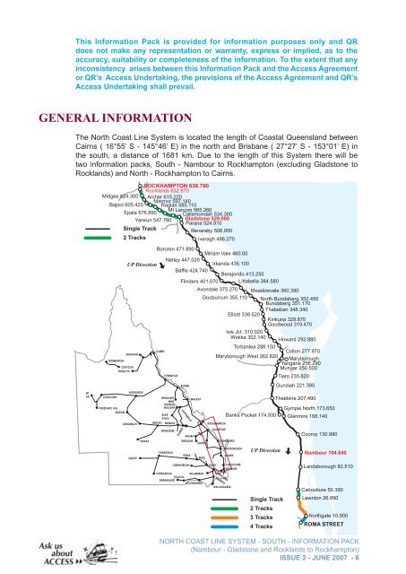
GENERAL INFORMATION<br />
The <strong>North</strong> <strong>Coast</strong> <strong>Line</strong> System is located the length of <strong>Coast</strong>al <strong>Queensland</strong> between<br />
Cairns ( 16°55’ S - 145°46’ E) in the north and Brisbane ( 27°27’ S - 153°01’ E) in<br />
the south, a distance of 1681 km. Due to the length of this System there will be<br />
two information packs, <strong>South</strong> - Nambour to Rockhampton (excluding Gladstone to<br />
Rocklands) and <strong>North</strong> - Rockhampton to Cairns.<br />
MT<br />
ISA<br />
ROCKHAMPTON 638.790<br />
Rocklands 632.970<br />
Midgee 624.300 Archer 615.220<br />
Marmor 597.140<br />
Bajool 605.420 Raglan 585.110<br />
Mt Larcom 565.260<br />
Epala 576.890<br />
Callemondah 534.300<br />
Yarwun 547.760 Gladstone 529.000<br />
Parana 524.910<br />
Single Track<br />
Benaraby 506.950<br />
2 Tracks<br />
Iveragh 486.270<br />
NORMANTON<br />
CLONCURRY<br />
CROYDON<br />
FORSAYTH<br />
PHOSPHATE HILL<br />
WINTON<br />
Bororen 471.890<br />
Miriam Vale 460.00<br />
UP Direction<br />
Netley 447.020<br />
Irkanda 435.100<br />
Baffle 424.740<br />
Berajondo 413.250<br />
Flinders 401.070 Littabella 384.580<br />
MUNGANA<br />
HUGHENDEN<br />
LONGREACH<br />
QUILPIE<br />
YARAKA<br />
CAIRNS<br />
TOWNSVILLE<br />
NEWLANDS<br />
MINE<br />
RIVERSIDE<br />
MALLAWA<br />
BLAIR<br />
ATHOL<br />
JERICHO EMERALD<br />
SPRINGSURE<br />
CHARLEVILLE<br />
BOWEN<br />
COPPABELLA<br />
TOLMIES<br />
MOURA<br />
THEODORE<br />
ROMA<br />
GLENMORGAN<br />
Avondale 375.270 Meadowvale 360.390<br />
Gooburrum 355.110 <strong>North</strong> Bundaberg 352.450<br />
Bundaberg 351.170<br />
Thabeban 348.340<br />
Elliott 338.520<br />
Kinkuna 329.870<br />
Goodwood 319.470<br />
Isis Jct. 310.020<br />
Wokka 302.140<br />
Howard 292.880<br />
Torbanlea 288.150<br />
Colton 277.970<br />
Maryborough West 262.820<br />
Maryborough<br />
Yengarie 256.290<br />
Mungar 250.500<br />
MACKAY<br />
MONTO<br />
MILES<br />
CUNNAMULLA<br />
MILLMERRAN<br />
THALLON<br />
DIRRANBANDI<br />
GOONDIWINDI<br />
ROCKHAMPTON<br />
GLADSTONE<br />
DALBY<br />
TOOWOOMBA<br />
WARWICK<br />
Banks Pocket 174.930<br />
BUNDABERG<br />
GYMPIE<br />
WALLANGARRA<br />
MARYBOROUGH<br />
CABOOLTURE<br />
BRISBANE<br />
UP Direction<br />
Single Track<br />
2 Tracks<br />
3 Tracks<br />
4 Tracks<br />
Tiaro 235.820<br />
Gundiah 221.390<br />
Theebine 207.490<br />
Gympie <strong>North</strong> 173.650<br />
Glanmire 168.140<br />
Cooroy 130.990<br />
Nambour 104.840<br />
Landsborough 82.510<br />
Caboolture 50.390<br />
Lawnton 26.890<br />
<strong>North</strong>gate 10.900<br />
ROMA STREET<br />
NORTH COAST LINE SYSTEM - SOUTH - INFORMATION PACK<br />
(Nambour - Gladstone and Rocklands to Rockhampton)<br />
ISSUE 2 - JUNE 2007 -