North Coast Line South Information Pack - Queensland Rail
North Coast Line South Information Pack - Queensland Rail
North Coast Line South Information Pack - Queensland Rail

Create successful ePaper yourself
Turn your PDF publications into a flip-book with our unique Google optimized e-Paper software.
Changes to the sectional running times for the system are also possible over time. Any<br />
changes would be confirmed as part of the access agreement negotiations.<br />
Trains travelling south to Brisbane are travelling in the Up Direction whilst trains travelling<br />
north to Cairns are travelling in the Down Direction.<br />
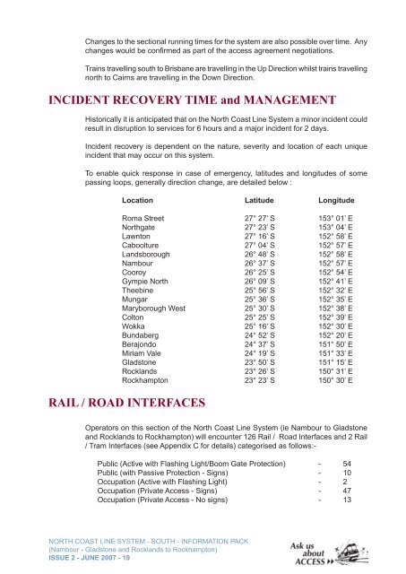
INCIDENT RECOVERY TIME and MANAGEMENT<br />
Historically it is anticipated that on the <strong>North</strong> <strong>Coast</strong> <strong>Line</strong> System a minor incident could<br />
result in disruption to services for 6 hours and a major incident for 2 days.<br />
Incident recovery is dependent on the nature, severity and location of each unique<br />
incident that may occur on this system.<br />
To enable quick response in case of emergency, latitudes and longitudes of some<br />
passing loops, generally direction change, are detailed below :<br />
Location Latitude Longitude<br />
Roma Street 27° 27’ S 153° 01’ E<br />
<strong>North</strong>gate 27° 23’ S 153° 04’ E<br />
Lawnton 27° 16’ S 152° 58’ E<br />
Caboolture 27° 04’ S 152° 57’ E<br />
Landsborough 26° 48’ S 152° 58’ E<br />
Nambour 26° 37’ S 152° 57’ E<br />
Cooroy 26° 25’ S 152° 54’ E<br />
Gympie <strong>North</strong> 26° 09’ S 152° 41’ E<br />
Theebine 25° 56’ S 152° 32’ E<br />
Mungar 25° 36’ S 152° 35’ E<br />
Maryborough West 25° 30’ S 152° 38’ E<br />
Colton 25° 25’ S 152° 39’ E<br />
Wokka 25° 16’ S 152° 30’ E<br />
Bundaberg 24° 52’ S 152° 20’ E<br />
Berajondo 24° 37’ S 151° 50’ E<br />
Miriam Vale 24° 19’ S 151° 33’ E<br />
Gladstone 23° 50’ S 151° 15’ E<br />
Rocklands 23° 26’ S 150° 31’ E<br />
Rockhampton 23° 23’ S 150° 30’ E<br />
RAIL / ROAD INTERFACES<br />
Operators on this section of the <strong>North</strong> <strong>Coast</strong> <strong>Line</strong> System (ie Nambour to Gladstone<br />
and Rocklands to Rockhampton) will encounter 126 <strong>Rail</strong> / Road Interfaces and 2 <strong>Rail</strong><br />
/ Tram Interfaces (see Appendix C for details) categorised as follows:-<br />
Public (Active with Flashing Light/Boom Gate Protection) - 54<br />
Public (with Passive Protection - Signs) - 10<br />
Occupation (Active with Flashing Light) - 2<br />
Occupation (Private Access - Signs) - 47<br />
Occupation (Private Access - No signs) - 13<br />
NORTH COAST LINE SYSTEM - SOUTH - INFORMATION PACK<br />
(Nambour - Gladstone and Rocklands to Rockhampton)<br />
ISSUE 2 - JUNE 2007 - 19