Remote Sensing Hydrosphere - North Carolina Science Olympiad
Remote Sensing Hydrosphere - North Carolina Science Olympiad
Remote Sensing Hydrosphere - North Carolina Science Olympiad

Create successful ePaper yourself
Turn your PDF publications into a flip-book with our unique Google optimized e-Paper software.
October 8, 2011<br />
DIVISION C<br />
NC <strong>Science</strong> <strong>Olympiad</strong><br />
Oct 2011-12 Coaches Institute<br />
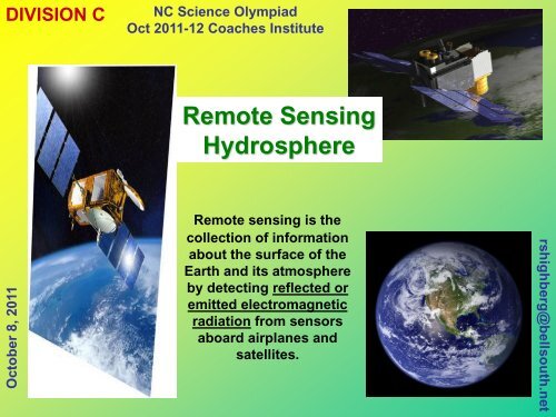
<strong>Remote</strong> <strong>Sensing</strong><br />
<strong>Hydrosphere</strong><br />
<strong>Remote</strong> sensing is the<br />
collection of information<br />
about the surface of the<br />
Earth and its atmosphere<br />
by detecting reflected or<br />
emitted electromagnetic<br />
radiation from sensors<br />
aboard airplanes and<br />
satellites.<br />
rshighberg@bellsouth.net
October 8, 2011<br />
<strong>Remote</strong> <strong>Sensing</strong>-Hydrospere<br />
2011-12<br />
event rules<br />
NC <strong>Science</strong> <strong>Olympiad</strong> Oct 2011 Coaches Institute<br />
rshighberg@bellsouth.net
October 8, 2011<br />
DIVISION C<br />
NC <strong>Science</strong> <strong>Olympiad</strong><br />
Oct 2011-12 Coaches Institute<br />
2011-12 <strong>Remote</strong> <strong>Sensing</strong><br />
WHAT THE 2011-12 EVENT WILL NOT BE ABOUT<br />
In <strong>North</strong> <strong>Carolina</strong> Tournaments, students are not expected to study all the<br />
science related to the Earth’s <strong>Hydrosphere</strong>.<br />
For instance, for impacts to coral reefs, students are not expected to<br />
know marine biology. That is left to the Oceanography event. For changes in<br />
ice caps & glaciers, students are not expected to know the science behind<br />
glaciers. That is left to the Dynamic Planet event.<br />
WHAT THE 2011-12 EVENT WILL BE ABOUT<br />
The <strong>North</strong> <strong>Carolina</strong> remote sensing event will focus on how remote<br />
sensing satellites and sensors help scientists and planners to gather and<br />
analyze data related to their particular specialties related to Earth’s<br />
<strong>Hydrosphere</strong>. Such specialties include; oceanography, meteorology,<br />
agriculture, hydrology, flood control, glaciology, etc.<br />
<strong>Remote</strong> sensing is particularly good at detecting (1) changes over time,<br />
(2) Ice, snow, and/or cloud cover for vast areas at the same time, (3) data<br />
on Inaccessible areas, and using wavelengths beyond the visible light<br />
that our eyes cannot see.<br />
The event is about the WHAT, the HOW, and the WHY for information<br />
obtained by remote sensors related to the Earth’s <strong>Hydrosphere</strong>.<br />
Slide 3<br />
rshighberg@bellsouth.net
October 8, 2011<br />
DIVISION C<br />
NC <strong>Science</strong> <strong>Olympiad</strong><br />
Oct 2011-12 Coaches Institute<br />
TECHNICAL STUFF ... the BLACK MAGIC part<br />
2011-12 <strong>Remote</strong> <strong>Sensing</strong><br />
WHERE ON THE EARTH IS THAT Students should be familiar with various<br />
geographic coordinate systems used to locate images, how to translate these into<br />
distances, how to determine and use image scales<br />
HOW IN SPACE DID WE OBTAIN THAT Students should be familiar with NASA’s<br />
earth resources satellites, basic science objectives, orbits, sensor systems used to detect<br />
and observe the hydrosphere, and electro-magnetic spectrum’s interaction with the<br />
atmosphere and earth surface.<br />
HOW ON EARTH DID THAT PRETTY IMAGE COME FROM ONES AND ZEROS <br />
Students should be familiar with the basics of digital image processing.<br />
APPLICATION STUFF ... the SCIENCE part<br />
OBSERVABLE CHANGES (IMPACTS)<br />
IN THE ENVIRONMENT <br />
FLOOD EVENTS; TSUNAMIS; STORM EVENTS<br />
AGRICULTURAL USE OF WATER<br />
DAM BUILDING - RESERVOIRS<br />
SHRINKING LAKES; CHANGING SEA LEVEL<br />
ICECAP THICKNESSES, GLACIAL RETREAT AND<br />
CALVING; SNOW COVER; CLOUD COVER<br />
OCEAN PRODUCTIVITY, TEMPERATURE, HEIGHT<br />
HUMAN ACTIONS &<br />
REACTIONS<br />
CITIES IN THE DESERT<br />
AGRICULTURE<br />
OCEAN POLLUTION,<br />
CLIMATE CHANGE – SEVERE STORMS<br />
DAMMING RIVERS,<br />
WATER DIVERSIONS<br />
Slide 4<br />
rshighberg@bellsouth.net
DIVISION C<br />
NC <strong>Science</strong> <strong>Olympiad</strong><br />
OCT 2011-12 Coaches Institute<br />
<strong>Remote</strong> <strong>Sensing</strong><br />
<strong>Remote</strong> <strong>Sensing</strong> of Earth’s <strong>Hydrosphere</strong><br />
∙ Earth Resource missions (currently operational)<br />
∙ Sensor systems and characteristics applicable to water on earth’s<br />
surface and atmosphere<br />
∙ Internet-accessible satellite images and scientific studies<br />
•Student understanding of the science …<br />
Water in all its states (solid, liquid and gas) can be observed<br />
directly and/or indirectly from orbital platforms<br />
Mapping and <strong>Remote</strong> <strong>Sensing</strong> Basics<br />
∙ Examples of <strong>Remote</strong> <strong>Sensing</strong><br />
∙ Maps, coordinates, scales, measurements and proportions<br />
∙ Aerial Photography ... focal length and altitude ratios<br />
∙ Electromagnetic spectrum ... capturing and counting photons<br />
∙ Converting data to visual images (RGB)<br />
∙ Atmospheric Windows ... absorption and scattering effects<br />
∙ Passive and Active systems<br />
∙ Sensor Resolution ... spatial, spectral and temporal<br />
∙ Getting the most from the data ... digital signal enhancement<br />
October 8, 2011<br />
Slide5<br />
rshighberg@bellsouth.net
DIVISION C<br />
NC <strong>Science</strong> <strong>Olympiad</strong><br />
Oct 2011-12 Coaches Institute<br />
<strong>Remote</strong> <strong>Sensing</strong><br />
What’s the next part of this presentation <br />
NASA / ESA Earth Resources Satellite Missions<br />
Where to find this information<br />
Sensor Systems carried onboard<br />
Where to find this information<br />
Images and <strong>Science</strong> from Internet-accessible NASA collections<br />
Where to find this information<br />
The type of information a student will be expected to determine<br />
from her/his evaluation of satellite images<br />
October 8, 2011<br />
Slide 6<br />
rshighberg@bellsouth.net
DIVISION C<br />
NC <strong>Science</strong> <strong>Olympiad</strong><br />
Oct 2011-12 Coaches Institute<br />
<strong>Remote</strong> <strong>Sensing</strong><br />
<strong>Remote</strong> <strong>Sensing</strong> of Land Use<br />
INTERNET PORTALS<br />
NASA Earth Satellite Programs<br />
Earth Observing Sysem<br />
http://www.nasa.gov/missions/index.html<br />
http://mpfwww.jpl.nasa.gov/missions/log/<br />
http://nasascience.nasa.gov/earth-science/mission_list<br />
http://mpfwww.jpl.nasa.gov/mro/<br />
Satellites<br />
IMAGE Collections<br />
Scientific Feature Articles<br />
http://nasascience.nasa.gov/missions<br />
http://visibleearth.nasa.gov/<br />
http://earthobservatory.nasa.gov/Features/<br />
NC <strong>Science</strong> <strong>Olympiad</strong> Coaches Institute<br />
This Coaches Institute presentation will be posted on the NCSO webpage<br />
October 8, 2011<br />
Slide 7<br />
rshighberg@bellsouth.net
DIVISION C<br />
NC <strong>Science</strong> <strong>Olympiad</strong><br />
2011-12 Coaches Institute<br />
<strong>Remote</strong> <strong>Sensing</strong><br />
Earth Observing System<br />
LANDSAT 7 http://landsat.gsfc.nasa.gov/<br />
QuickSCAT<br />
TERRA http://terra.nasa.gov/<br />
JASON-1<br />
AQUA http://aqua.nasa.gov/<br />
SEAWINDS<br />
ICESat http://icesat.gsfc.nasa.gov/<br />
AURA http://aura.gsfc.nasa.gov/<br />
OSTM<br />
TRMM http://trmm.gsfc.nasa.gov<br />
EARTH OBSERVING-1 (EO-1)<br />
http://www.nasa.gov/mission_pages/ostm/main/index.html<br />
http://eo1.gsfc.nasa.gov<br />
http://eospso.gsfc.nasa.gov/<br />
http://eospso.gsfc.nasa.gov/eos_homepage/mission_profiles/show_mission_list.phpid=2<br />
October 8, 2011<br />
Slide 8<br />
rshighberg@bellsouth.net
ETM+<br />
(Enhanced Thematic Mapper Plus)<br />
DIVISION C<br />
NC <strong>Science</strong> <strong>Olympiad</strong><br />
2011-12 Coaches Institute<br />
<strong>Remote</strong> <strong>Sensing</strong><br />
LANDSAT-7<br />
http://landsat.gsfc.nasa.gov/ http://landsathandbook.gsfc.nasa.gov/handbook/handbook_toc.html<br />
http://eospso.gsfc.nasa.gov/eos_homepage/mission_profiles/show_mission.phpid=33<br />
October 8, 2011<br />
Slide 9<br />
rshighberg@bellsouth.net
DIVISION C<br />
NC <strong>Science</strong> <strong>Olympiad</strong><br />
2011-12 Coaches Institute<br />
<strong>Remote</strong> <strong>Sensing</strong><br />
TERRA<br />
ASTER<br />
(Advanced Spaceborne Thermal Emission and Reflection Radiometer)<br />
CERES<br />
(Clouds and Earth's Radiant Energy System)<br />
MISR<br />
(Multiangle Imaging Spectroradiometer)<br />
MODIS<br />
(Moderate-Resolution Imaging Spectroradiometer)<br />
MOPITT<br />
(Measurements of Pollution in the Troposphere)<br />
http://eospso.gsfc.nasa.gov/eos_homepage/mission_profiles/show_mission.phpid=35<br />
October 8, 2011<br />
Slide 10<br />
rshighberg@bellsouth.net
DIVISION C<br />
AQUA<br />
NC <strong>Science</strong> <strong>Olympiad</strong><br />
2011-12 Coaches Institute<br />
<strong>Remote</strong> <strong>Sensing</strong><br />
AIRS<br />
(Atmospheric Infrared Sounder)<br />
AMSR<br />
(Advanced Microwave Scanning Radiometer)<br />
AMSU-A<br />
(Advanced Microwave Sounding Unit-A)<br />
CERES<br />
(Clouds and Earth's Radiant Energy System)<br />
HSB<br />
(Humidity Sounder for Brazil)<br />
MODIS<br />
(Moderate-Resolution Imaging Spectroradiometer )<br />
http://www.nasa.gov/mission_pages/aqua/index.html<br />
http://eospso.gsfc.nasa.gov/eos_homepage/mission_profiles/show_mission.phpid=11<br />
October 8, 2011<br />
Slide 11<br />
rshighberg@bellsouth.net
DIVISION C<br />
NC <strong>Science</strong> <strong>Olympiad</strong><br />
Oct 2011-12 Coaches Institute<br />
<strong>Remote</strong> <strong>Sensing</strong><br />
EARTH OBSERVING – 1<br />
(EO-1)<br />
ALI<br />
(Advanced Land Imager )<br />
Hyperion<br />
(Hyperion Hyperspectral Imager )<br />
http://www.nasa.gov/mission_pages/aqua/index.html<br />
http://eospso.gsfc.nasa.gov/eos_homepage/mission_profiles/show_mission.phpid=11<br />
October 8, 2011<br />
Slide 12<br />
rshighberg@bellsouth.net
DIVISION C<br />
NC <strong>Science</strong> <strong>Olympiad</strong><br />
2011-12 Coaches Institute<br />
<strong>Remote</strong> <strong>Sensing</strong><br />
MODIS ... (Moderate-Resolution Imaging Spectroradiometer)<br />
http://modarch.gsfc.nasa.gov/<br />
ASTER ... (Advanced Spaceborne Thermal Emission and Reflection Radiometer)<br />
http://asterweb.jpl.nasa.gov/<br />
CERES ... (Clouds and Earth's Radiant Energy System)<br />
http://science.larc.nasa.gov/ceres/index.html<br />
MISR ... (Multiangle Imaging Spectroradiometer)<br />
http://www-misr.jpl.nasa.gov/<br />
MOPITT ... (Measurements of Pollution in the Troposphere)<br />
http://mopitt.eos.ucar.edu/mopitt/<br />
H2O SENSORS FLOWN ON TERRA<br />
http://eospso.gsfc.nasa.gov/eos_homepage/mission_profiles/show_mission.phpid=35<br />
October 8, 2011<br />
Slide 13<br />
rshighberg@bellsouth.net
DIVISION C<br />
NC <strong>Science</strong> <strong>Olympiad</strong><br />
2011-12 Coaches Institute<br />
<strong>Remote</strong> <strong>Sensing</strong><br />
Satellite Altimetry<br />
http://www.aviso.oceanobs.com/en/missions/index.html<br />
October 8, 2011<br />
Slide 14<br />
rshighberg@bellsouth.net
DIVISION C<br />
NC <strong>Science</strong> <strong>Olympiad</strong><br />
2011-12 Coaches Institute<br />
<strong>Remote</strong> <strong>Sensing</strong><br />
TOPEX-POSEIDON<br />
OSTM-JASON 1 & 2<br />
http://topex-www.jpl.nasa.gov/overview/overview.html<br />
http://topex-www.jpl.nasa.gov/mission/mission.html<br />
http://topex-www.jpl.nasa.gov/technology/instrument.html<br />
October 8, 2011<br />
Slide 15<br />
rshighberg@bellsouth.net
DIVISION C<br />
NC <strong>Science</strong> <strong>Olympiad</strong><br />
2011-12 Coaches Institute<br />
<strong>Remote</strong> <strong>Sensing</strong><br />
•Precipitation Radar (PR)<br />
TRMM Microwave Imager (TMI)<br />
•Visible and InfraRed Scanner (VIRS)<br />
•Cloud and Earth Radiant Energy Sensor (CERES)<br />
•Lightning Imaging Sensor (LIS)<br />
http://trmm.gsfc.nasa.gov/<br />
October 8, 2011<br />
Slide 16<br />
rshighberg@bellsouth.net
Slide 17
DIVISION C<br />
NC <strong>Science</strong> <strong>Olympiad</strong><br />
2011-12 Coaches Institute<br />
<strong>Remote</strong> <strong>Sensing</strong><br />
Orbital Information from heavens-above.com<br />
http://www.heavens-above.com/selectsat.asplat=40.015&lng=-105.270&loc=Boulder&alt=1646&tz=MST<br />
Orbit: 701 x 703 km, 98.2°<br />
Polar, Sun-synchronous<br />
October 8, 2011<br />
Slide 18<br />
rshighberg@bellsouth.net
DIVISION C<br />
NC <strong>Science</strong> <strong>Olympiad</strong><br />
2011-12 Coaches Institute<br />
<strong>Remote</strong> <strong>Sensing</strong><br />
Image Collection Portal ...<br />
http://visibleearth.nasa.gov/<br />
October 8, 2011<br />
Slide 19<br />
rshighberg@bellsouth.net
DIVISION C<br />
NC <strong>Science</strong> <strong>Olympiad</strong><br />
2011 Coaches Institute<br />
<strong>Remote</strong> <strong>Sensing</strong><br />
Earth Observatory Features ... http://earthobservatory.nasa.gov/Study/<br />
October 8, 2011<br />
Slide 20<br />
rshighberg@bellsouth.net
DIVISION C<br />
NC <strong>Science</strong> <strong>Olympiad</strong><br />
Oct 2011-12 Coaches Institute<br />
<strong>Remote</strong> <strong>Sensing</strong><br />
Earth Observatory Features ...<br />
http://earthobservatory.nasa.gov/Features/<br />
Irrigation in Turkey<br />
There are many feature articles<br />
on the Earth Observatory site<br />
dealing with satellite remote<br />
sensing related to the Earth’s<br />
<strong>Hydrosphere</strong> and the potential<br />
relationships with … carbon<br />
cycle, global climate change,<br />
dams and diversions,<br />
agriculture, land use changes,<br />
urbanization, resource<br />
extraction, polar ice cover,<br />
yearly snowpack, severe storm<br />
events (hurricanes), etc.<br />
October 8, 2011<br />
Slide 21<br />
rshighberg@bellsouth.net
DIVISION C<br />
NC <strong>Science</strong> <strong>Olympiad</strong><br />
2011 Coaches Institute<br />
<strong>Remote</strong> <strong>Sensing</strong><br />
Earth Observatory Features ... http://terra.nasa.gov/<br />
http://earthobservatory.nasa.gov/Study/IceMoving/<br />
http://earthobservatory.nasa.gov/Study/ArcticReflector/<br />
October 8, 2011<br />
http://earthobservatory.nasa.gov/Study/HighWater/<br />
Slide 22<br />
rshighberg@bellsouth.net
DIVISION C<br />
NC <strong>Science</strong> <strong>Olympiad</strong><br />
Oct 2011-12 Coaches Institute<br />
<strong>Remote</strong> <strong>Sensing</strong><br />
Earth Observatory Features ...<br />
http://earthobservatory.nasa.gov/Features/<br />
October 8, 2011<br />
Slide 23<br />
rshighberg@bellsouth.net
Temporal<br />
Comparisons<br />
DIVISION C<br />
NC <strong>Science</strong> <strong>Olympiad</strong><br />
Oct 2011-12 Coaches Institute<br />
<strong>Remote</strong> <strong>Sensing</strong><br />
Amazon Deforestation … 2000 to 2009<br />
Students may (1) determine image scales (2) measure distances and areas<br />
(km, square km), (3) make quantitative and qualitative assessments,<br />
(4) comment on technologies used to obtain and calibrate the images, etc.<br />
City Lights<br />
Bolivian Agriculture<br />
City Lights<br />
October 8, 2011<br />
Slide 24<br />
rshighberg@bellsouth.net
DIVISION C<br />
NC <strong>Science</strong> <strong>Olympiad</strong> 2011-12 Coaches Institute<br />
<strong>Remote</strong> <strong>Sensing</strong><br />
<strong>Remote</strong> <strong>Sensing</strong> Image Scale Tutorial<br />
… see NCSO Resource Page<br />
Using PROPORTIONS to determine the unknown<br />
scale of an enlarged or reduced image from an<br />
original image with a known scale<br />
ORIGINAL IMAGE<br />
Scale 1 : 296,000<br />
(Step 1) Set up equivalence between original and reduced<br />
images<br />
(12.5 cm) x (296,000) = (7 cm) X (unknown scale)<br />
(Step 2) Solve for the unknown scale<br />
(unknown scale = (12.5 cm X 296,000) / (7 cm)<br />
(Step 3) Solve for the unknown scale<br />
unknown scale = 528,571<br />
(Step 4) The non-dimensional scale of the reduced image is ...<br />
1 : 528,571<br />
(Step 5) Is the computed scale logical YES<br />
37 KM<br />
Real World<br />
12.5 cm<br />
in image<br />
7 cm<br />
in image<br />
October 8, 2011<br />
51 KM<br />
Real World<br />
NOTE: measurements in this sample calculation will not match those from your printout due the size of paper you’ve printed, or automatic<br />
shrinking/stretching accomplished by your software and/or printer. Original was 11x17. Presentation is 8-1/2x11.<br />
Slide 25<br />
REDUCED IMAGE<br />
rshighberg@bellsouth.net
DIVISION C<br />
NC <strong>Science</strong> <strong>Olympiad</strong><br />
Oct 2011-12 Coaches Institute<br />
<strong>Remote</strong> <strong>Sensing</strong><br />
Mapping and <strong>Remote</strong> <strong>Sensing</strong> Basics<br />
∙ Examples of <strong>Remote</strong> <strong>Sensing</strong> – discuss differences between in situ<br />
and remote “sensing” ... at a distance<br />
electromagmetic radiation (sight)<br />
physical vibrations (sound)<br />
∙ Instruments used for <strong>Remote</strong> <strong>Sensing</strong> – discuss how we “capture”<br />
and interpret remotely sensed data<br />
instruments used<br />
means for transmitting data<br />
interpretation of data<br />
October 8, 2011<br />
Slide 26<br />
rshighberg@bellsouth.net
DIVISION C<br />
NC <strong>Science</strong> <strong>Olympiad</strong><br />
Oct 201112 Coaches Institute<br />
<strong>Remote</strong> <strong>Sensing</strong><br />
Mapping and <strong>Remote</strong> <strong>Sensing</strong> Basics<br />
∙ Maps, coordinates, scales, measurements and proportions<br />
Discussion of maps, coordinate systems and scales<br />
English and metric scales<br />
Coordinate grids ... Cartesian, Geographic, UTM<br />
Problem: determine coordinates of a feature on a map.<br />
Problem: determine dimensionless map scale<br />
Problem: convert a map measurement to a real distance<br />
Problem: proportion measurements from map to image<br />
October 8, 2011<br />
Slide 27<br />
rshighberg@bellsouth.net
DIVISION C<br />
NC <strong>Science</strong> <strong>Olympiad</strong><br />
Oct 2011-12 Coaches Institute<br />
<strong>Remote</strong> <strong>Sensing</strong><br />
Mapping and <strong>Remote</strong> <strong>Sensing</strong> Basics<br />
Geographic Coordinate System<br />
Familiar Latitude and Longitude<br />
LATITUDE ... 0-90 degrees north and south of Equator<br />
Latitude - distance per degree is constant globally<br />
LONGITUDE ... 0-180 degrees east and west of Prime Meridian<br />
Longitude - distance per degree is NOT constant globally<br />
Universal Transverse Mercator (UTM)<br />
Distances in METERS north of Equator and north of South Pole<br />
Southern Hemisphere starts at 10,000,000 m<br />
Distances in METERS east of “false” baseline<br />
500,000 m EASTING at center of ZONE<br />
60 Zones worldwide, each 6-degrees wide<br />
Right-angle system allows direct computation of distances in zone<br />
October 8, 2011<br />
Slide 28<br />
rshighberg@bellsouth.net
DIVISION C<br />
NC <strong>Science</strong> <strong>Olympiad</strong><br />
Oct 2011-12 Coaches Institute<br />
<strong>Remote</strong> <strong>Sensing</strong><br />
Mapping and <strong>Remote</strong> <strong>Sensing</strong> Basics<br />
∙ Aerial Photography ... focal length and altitude ratios<br />
Discussion of focal length, film/sensor dimensions and relationship to<br />
distances on the ground<br />
Diagram showing focal ratios.<br />
Problem: determine ground frame width of an aerial photo<br />
(use examples of 9x9 negatives)<br />
Problem: determine altitude needed for a scaled photo<br />
(use examples of 9x9 negatives)<br />
Discussion of proportionality relationships and scale ratios for digital sensor<br />
systems with the PIXEL as the smallest unit of data capture<br />
October 8, 2011<br />
Slide 29<br />
rshighberg@bellsouth.net
DIVISION C<br />
NC <strong>Science</strong> <strong>Olympiad</strong><br />
Oct 2011-12 Coaches Institute<br />
<strong>Remote</strong> <strong>Sensing</strong><br />
http://rst.gsfc.nasa.gov/Sect10/Sect10_1.html<br />
October 8, 2011<br />
Slide 30<br />
rshighberg@bellsouth.net
DIVISION C<br />
NC <strong>Science</strong> <strong>Olympiad</strong><br />
Oct 2011-12 Coaches Institute<br />
<strong>Remote</strong> <strong>Sensing</strong><br />
Mapping and <strong>Remote</strong> <strong>Sensing</strong> Basics<br />
∙ Electromagnetic spectrum ... capturing and counting photons<br />
Discussion of energy versus wavelength; gamma, x-ray, UV, visible, IR, and<br />
radio waves.<br />
E-M Spectrum Diagrams<br />
Discussion of analog (film) and digital data collection; multi-spectral versus<br />
frequency-specific data capture<br />
Discussion of “visualizations” of data, and false color images<br />
Color Infrared RGB (red, green, blue) assignments<br />
October 8, 2011<br />
Slide 30<br />
rshighberg@bellsouth.net
DIVISION C<br />
NC <strong>Science</strong> <strong>Olympiad</strong><br />
Oct 2011-12 Coaches Institute<br />
<strong>Remote</strong> <strong>Sensing</strong><br />
October 8, 2011<br />
Slide 31<br />
rshighberg@bellsouth.net
DIVISION C<br />
NC <strong>Science</strong> <strong>Olympiad</strong><br />
Oct 2011-12 Coaches Institute<br />
<strong>Remote</strong> <strong>Sensing</strong><br />
Mapping and <strong>Remote</strong> <strong>Sensing</strong> Basics<br />
▪ Absorption and scattering effects ...<br />
http://ccrs.nrcan.gc.ca/resource/tutor/fundam/chapter1/04_e.php<br />
Mie scattering, Raleigh scattering, non-selective scattering<br />
absorption<br />
Relationship between wavelength and particle/molecule size<br />
∙ Atmospheric Windows ...<br />
Restricts wavelengths available for remote sensing use<br />
Visible, Near IR, Short Wave IR, Far (thermal IR), Radio<br />
Function of atmospheric composition and density<br />
October 8, 2011<br />
Slide 32<br />
rshighberg@bellsouth.net
DIVISION C<br />
NC <strong>Science</strong> <strong>Olympiad</strong><br />
Oct 2011-12 Coaches Institute<br />
<strong>Remote</strong> <strong>Sensing</strong><br />
October 8, 2011<br />
Slide 33<br />
rshighberg@bellsouth.net
DIVISION C<br />
NC <strong>Science</strong> <strong>Olympiad</strong><br />
Oct 2011-12 Coaches Institute<br />
<strong>Remote</strong> <strong>Sensing</strong><br />
Mapping and <strong>Remote</strong> <strong>Sensing</strong> Basics<br />
▪ Passive Sensor Systems ...<br />
Discuss energy sources for passive systems<br />
Discuss energy levels (radiometric resolution)<br />
Affects time available for data acquisition<br />
Affected by atmospheric effects (moisture, cloud cover)<br />
∙ Active Sensor Systems ...<br />
RADAR<br />
LIDAR<br />
Can choose penetrating wavelengths to see through clouds<br />
Requires higher power level onboard sensor platform<br />
Can “see” during the dark side of polar orbits<br />
http://ccrs.nrcan.gc.ca/resource/tutor/fundam/chapter1/06_e.php<br />
October 8, 2011<br />
Slide 34<br />
rshighberg@bellsouth.net
DIVISION C<br />
NC <strong>Science</strong> <strong>Olympiad</strong><br />
Oct 2011-12 Coaches Institute<br />
<strong>Remote</strong> <strong>Sensing</strong><br />
Mapping and <strong>Remote</strong> <strong>Sensing</strong> Basics<br />
▪ Sensor Resolutions ... Big tradeoff in mission design.<br />
Increasing one usual decreases another<br />
“Juggling” diagram<br />
Discuss the various sensor resolutions and how they vary<br />
Spatial ... Limiting object size<br />
Spectral ... Frequency discrimination<br />
Radiometric ... range of values, gray levels<br />
Temporal ... Revisit frequency<br />
Diagrams with digital sensor arrays and pixels<br />
▪ Scanner Systems ... Cross Track ... Along Track<br />
Diagram with scanner types<br />
▪ Orbits and Swaths ... Cross Track ... Along Track<br />
Diagram with orbital paths<br />
http://ccrs.nrcan.gc.ca/resource/tutor/fundam/chapter2/02_e.php<br />
October 8, 2011<br />
Slide 35<br />
rshighberg@bellsouth.net
DIVISION C<br />
NC <strong>Science</strong> <strong>Olympiad</strong><br />
Oct 2011-12 Coaches Institute<br />
<strong>Remote</strong> <strong>Sensing</strong><br />
October 8, 2011<br />
Slide 36<br />
rshighberg@bellsouth.net
DIVISION C<br />
NC <strong>Science</strong> <strong>Olympiad</strong><br />
Oct 2011-12 Coaches Institute<br />
<strong>Remote</strong> <strong>Sensing</strong><br />
Pixels detect light intensity as shades of gray.<br />
Filters limit the wavelengths coming in to each detector<br />
Panchromatic<br />
Visible Light<br />
http://hosting.soonet.ca/eliris/remotesensing/bl130lec10.html<br />
October 8, 2011<br />
Slide 37<br />
rshighberg@bellsouth.net
DIVISION C<br />
NC <strong>Science</strong> <strong>Olympiad</strong><br />
Oct 2011-12 Coaches Institute<br />
<strong>Remote</strong> <strong>Sensing</strong><br />
Image<br />
Type<br />
8-bit<br />
image<br />
16-bit<br />
image<br />
Pixel Value<br />
2 8 = 256 0-255<br />
Color<br />
Levels<br />
2 16 = 65536 0-65535<br />
24-bit<br />
image<br />
2 24 =<br />
16777216<br />
0-<br />
16777215<br />
2-bit image<br />
4 gray levels<br />
8-bit image<br />
256 gray levels<br />
http://hosting.soonet.ca/eliris/remotesensing/bl130lec10.html<br />
October 8, 2011<br />
Slide 38<br />
rshighberg@bellsouth.net
DIVISION C<br />
NC <strong>Science</strong> <strong>Olympiad</strong><br />
Oct 2011-12 Coaches Institute<br />
<strong>Remote</strong> <strong>Sensing</strong><br />
Whiskbroom Scanner<br />
Pushbroom Scanner<br />
October 8, 2011<br />
Slide 39<br />
rshighberg@bellsouth.net
DIVISION C<br />
NC <strong>Science</strong> <strong>Olympiad</strong><br />
Oct 2011-12 Coaches Institute<br />
<strong>Remote</strong> <strong>Sensing</strong><br />
Near-polar, Sun Synchronous Orbit<br />
http://ccrs.nrcan.gc.ca/resource/tutor/fundam/chapter2/02_e.php<br />
October 2, 2011<br />
Slide 40<br />
rshighberg@bellsouth.net
DIVISION C<br />
NC <strong>Science</strong> <strong>Olympiad</strong><br />
Oct 2011-12 Coaches Institute<br />
<strong>Remote</strong> <strong>Sensing</strong><br />
Mapping and <strong>Remote</strong> <strong>Sensing</strong> Basics<br />
▪ Getting the most from the data ... digital signal enhancement<br />
Diagrams and Images for “stretch” example and false color<br />
Problem: determine min and max values for 2-bit and 8-bit<br />
processors<br />
Problem: determine gray levels for 6-bit processor<br />
Problem: what wavelengths are usually combined for<br />
“Color Infra-Red” images<br />
Discuss comparison with Ansel Adams’ ZONE SYSTEM for black and<br />
white film photography<br />
http://hosting.soonet.ca/eliris/remotesensing/bl130lec10.html<br />
October 8, 2011<br />
Slide 41<br />
rshighberg@bellsouth.net
DIVISION C<br />
NC <strong>Science</strong> <strong>Olympiad</strong><br />
Oct 2011-12 Coaches Institute<br />
<strong>Remote</strong> <strong>Sensing</strong><br />
Linear Contrast Stretch<br />
R-G-B<br />
False<br />
Color<br />
Image<br />
Band 1 Band 2 Band 3<br />
October 8, 2011<br />
Slide 42<br />
rshighberg@bellsouth.net
DIVISION C<br />
NC <strong>Science</strong> <strong>Olympiad</strong><br />
Oct 2011-12 Coaches Institute<br />
<strong>Remote</strong> <strong>Sensing</strong><br />
Mapping and <strong>Remote</strong> <strong>Sensing</strong> Basics<br />
Canada Center For <strong>Remote</strong> <strong>Sensing</strong><br />
Fundamentals of <strong>Remote</strong> <strong>Sensing</strong> Tutorial<br />
http://ccrs.nrcan.gc.ca/resource/tutor/fundam/chapter1/01_e.php<br />
Digital Images and Digital Analysis Techniques Tutorial<br />
http://ccrs.nrcan.gc.ca/resource/tutor/digitech/index_e.php<br />
Glossary of <strong>Remote</strong> <strong>Sensing</strong> Terms<br />
http://ccrs.nrcan.gc.ca/glossary/index_e.php<br />
NASA <strong>Remote</strong> <strong>Sensing</strong> Tutorial<br />
http://rst.gsfc.nasa.gov/Front/tofc.html<br />
http://rst.gsfc.nasa.gov/Intro/Part2_1.html<br />
http://rst.gsfc.nasa.gov/Intro/Part2_4.html<br />
http://rst.gsfc.nasa.gov/Intro/Part2_5a.html<br />
http://rst.gsfc.nasa.gov/Intro/Part2_10.html<br />
http://rst.gsfc.nasa.gov/Intro/Part2_16.html<br />
http://rst.gsfc.nasa.gov/Intro/Part2_20.html<br />
http://rst.gsfc.nasa.gov/Intro/Part2_24.html<br />
October 8, 2011<br />
Slide 43<br />
rshighberg@bellsouth.net

![Shock Value Practice Test[1].pdf - Science Olympiad Student Center](https://img.yumpu.com/42685889/1/190x245/shock-value-practice-test1pdf-science-olympiad-student-center.jpg?quality=85)