Remote Sensing Hydrosphere - North Carolina Science Olympiad
Remote Sensing Hydrosphere - North Carolina Science Olympiad
Remote Sensing Hydrosphere - North Carolina Science Olympiad

You also want an ePaper? Increase the reach of your titles
YUMPU automatically turns print PDFs into web optimized ePapers that Google loves.
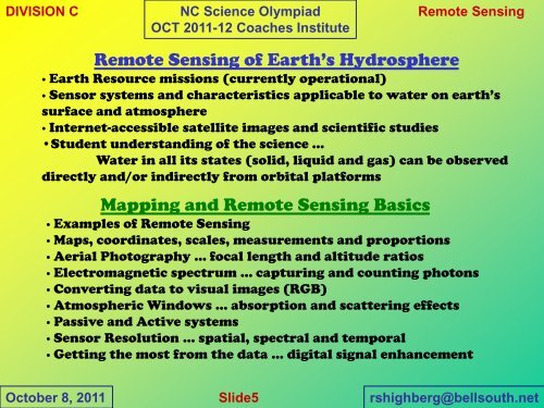
DIVISION C<br />
NC <strong>Science</strong> <strong>Olympiad</strong><br />
OCT 2011-12 Coaches Institute<br />
<strong>Remote</strong> <strong>Sensing</strong><br />
<strong>Remote</strong> <strong>Sensing</strong> of Earth’s <strong>Hydrosphere</strong><br />
∙ Earth Resource missions (currently operational)<br />
∙ Sensor systems and characteristics applicable to water on earth’s<br />
surface and atmosphere<br />
∙ Internet-accessible satellite images and scientific studies<br />
•Student understanding of the science …<br />
Water in all its states (solid, liquid and gas) can be observed<br />
directly and/or indirectly from orbital platforms<br />
Mapping and <strong>Remote</strong> <strong>Sensing</strong> Basics<br />
∙ Examples of <strong>Remote</strong> <strong>Sensing</strong><br />
∙ Maps, coordinates, scales, measurements and proportions<br />
∙ Aerial Photography ... focal length and altitude ratios<br />
∙ Electromagnetic spectrum ... capturing and counting photons<br />
∙ Converting data to visual images (RGB)<br />
∙ Atmospheric Windows ... absorption and scattering effects<br />
∙ Passive and Active systems<br />
∙ Sensor Resolution ... spatial, spectral and temporal<br />
∙ Getting the most from the data ... digital signal enhancement<br />
October 8, 2011<br />
Slide5<br />
rshighberg@bellsouth.net

![Shock Value Practice Test[1].pdf - Science Olympiad Student Center](https://img.yumpu.com/42685889/1/190x245/shock-value-practice-test1pdf-science-olympiad-student-center.jpg?quality=85)