RICHLAND COUNTY
RICHLAND COUNTY
RICHLAND COUNTY
Create successful ePaper yourself
Turn your PDF publications into a flip-book with our unique Google optimized e-Paper software.
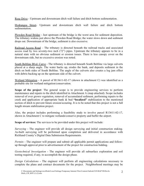
Rose Drive - Upstream and downstream ditch wall failure and ditch bottom sedimentation.<br />
Hydrangea Street- Upstream and downstream ditch wall failure and ditch bottom<br />
sedimentation.<br />
Plowden Road Bridge - Just upstream of the bridge is the worst area for sediment deposition.<br />
The tributary widens just above the Plowden Road Bridge; the water slows down and sediment<br />
drops out. Downstream of the bridge, sediment is also excessive.<br />
Railroad Access Road – The tributary is directed beneath the railroad tracks and associated<br />
access road by two seventy-two inch (72”) pipes. Upstream the tributary appears to be in a<br />
natural state with no obvious sediment or erosion issues. There is less canopy cover on the<br />
downstream side, but no excessive erosion was noted.<br />
South Beltline Blvd. Curve - The tributary is directed beneath South Beltline via large culverts<br />
placed at a sharp angle. The water backs up, erodes the bank, and deposits sediment in the<br />
ditch on both sides of South Beltline. The angle of the culverts also creates a log jam effect<br />
with debris backing up on the upstream side of the culvert.<br />
Wetland Mitigation - A parcel of R13611-02-17 (shown in attachment C) was identified as a<br />
probable site for wetland mitigation/conservation.<br />
Scope of the project: The general scope is to provide engineering services to perform<br />
maintenance and repairs to the ditch identified in Attachment A (map attached). Scope includes<br />
removal of over grown vegetation, removal of accumulated sediment, performing repairs to the<br />
creek and application of appropriate bank & bed “localized” stabilization to the mentioned<br />
section of ditch to prevent future erosion/scouring. It is to be noted that this project is not a full<br />
length stream stabilization project.<br />
Also, the project includes performing a feasibility study to involve parcel R13611-02-17,<br />
shown in Attachment C to mitigate wetlands/conserve property and buffer the airport.<br />
Scope of services: The services to be provided under this project will include:<br />
Surveying - The engineer will provide all design surveying and initial construction staking.<br />
As-built surveying will be performed upon completion and delivered in accordance with<br />
Richland County’s Digital Data Submission Requirements.<br />
Permits - The engineer will prepare and submit all applicable permit applications and followup<br />
through approval prior to advertisement of the project for construction bidding.<br />
Geotechnical Investigation - The engineer will provide all subsurface exploration and soil<br />
testing required, if any, to accomplish the design phase.<br />
Design Calculations - The engineer will perform all engineering calculations necessary to<br />
complete the plans and contract documents for the project. Neighborhood meetings may be<br />
C:\Documents and Settings\swoffordc\Local Settings\Temporary Internet Files\Content.Outlook\X3UBAFYB\Devils<br />
Ditch_CIP_RFP (1) (2).doc<br />
2


