Plant Communities of the Midwest - NatureServe
Plant Communities of the Midwest - NatureServe
Plant Communities of the Midwest - NatureServe

Create successful ePaper yourself
Turn your PDF publications into a flip-book with our unique Google optimized e-Paper software.
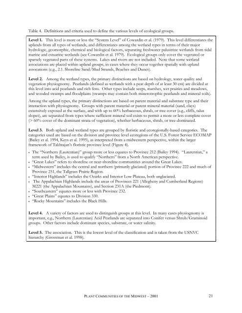
Table 4. Definitions and criteria used to define <strong>the</strong> various levels <strong>of</strong> ecological groups.<br />
Level 1. This level is more or less <strong>the</strong> “System Level” <strong>of</strong> Cowardin et al. (1979). This level differentiates <strong>the</strong><br />
uplands from all types <strong>of</strong> wetlands, and differentiates among <strong>the</strong> wetland types in terms <strong>of</strong> <strong>the</strong>ir major<br />
hydrologic, geomorphic, chemical and biological factors, separating freshwater palustrine wetlands from tidal<br />
marine and estuarine wetlands (see Cowardin et al. 1979). Ecological groups only cover <strong>the</strong> vegetated or<br />
sparsely vegetated parts <strong>of</strong> <strong>the</strong>se systems. Lakes and rivers are not included. Note that some wetland<br />
associations are placed within upland groups, in cases where <strong>the</strong>y occur toge<strong>the</strong>r spatially with upland<br />
assocations (e.g., 2.1. Shoreline Sand/Mud Strands, Beaches and Dunes).<br />
Level 2. Among <strong>the</strong> wetland types, <strong>the</strong> primary distinctions are based on hydrology, water quality and<br />
vegetation physiognomy. Peatlands (defined as wetlands with a peat depth <strong>of</strong> at least 30 cm) are divided at<br />
this level into acid peatlands and rich fens. O<strong>the</strong>r types include seeps, marshes, wet prairies and meadows,<br />
and wooded swamps and floodplains (swamps may contain both minerotrophic peatlands and mineral soils).<br />
Among <strong>the</strong> upland types, <strong>the</strong> primary distinctions are based on parent material and substrate type and <strong>the</strong>ir<br />
interaction with physiognomy. Groups with parent material or parent mineral material (sand, clays)<br />
extensively exposed at <strong>the</strong> surface, and with up to 60% herbaceous, shrub, or tree cover (e.g., cliffs, talus<br />
slopes), are separated from types where sufficient mineral soil exists to permit a more or less complete cover<br />
(> 60% cover <strong>of</strong> <strong>the</strong> dominant strata <strong>of</strong> vegetation), whe<strong>the</strong>r herbaceous, shrub, or tree-dominated.<br />
Level 3. Both upland and wetland types are grouped by floristic and ecoregionally-based categories. The<br />
categories used are based on <strong>the</strong> division and province level ecoregions <strong>of</strong> <strong>the</strong> U.S. Forest Service ECOMAP<br />
(Bailey et al. 1994, Keys et al. 1995), as interpreted from a midwestern perspective, within <strong>the</strong> larger<br />
framework <strong>of</strong> Takhtajan’s floristic province level (Figure 4).<br />
• The “Nor<strong>the</strong>rn (Laurentian)” group more or less equates to Province 212 (Bailey 1994). “Laurentian,” a<br />
term used by Bailey, is used to qualify “Nor<strong>the</strong>rn” from a North American perspective.<br />
• “Great Lakes” refers to shoreline or near-shoreline communities around <strong>the</strong> Great Lakes.<br />
• “<strong>Midwest</strong>ern” includes <strong>the</strong> central and nor<strong>the</strong>rn (primarily glaciated) portion <strong>of</strong> Province 222 and much <strong>of</strong><br />
Province 251, <strong>the</strong> Tallgrass Prairie Region.<br />
• “Interior Highlands” includes <strong>the</strong> Ozarks and Interior Low Plateau, both unglaciated.<br />
• The Appalachian Highlands include <strong>the</strong> areas <strong>of</strong> Provinces 221 (Allegheny and Cumberland Regions)<br />
M221 (<strong>the</strong> Appalachian Mountains), and Section 231A (<strong>the</strong> Piedmont).<br />
• “Sou<strong>the</strong>astern” equates more or less with Province 232.<br />
• “Great Plains” equates to Division 330.<br />
• “Rocky Mountains” includes <strong>the</strong> Black Hills.<br />
Level 4. A variety <strong>of</strong> factors are used to distinguish groups at this level. In many cases physiognomy is<br />
important, e.g., Nor<strong>the</strong>rn (Laurentian) Acid Peatlands are separated into Conifer versus Shrub/Graminoid<br />
groups. O<strong>the</strong>r factors include dominant species, substrate, or water salinity.<br />
Level 5. The association. This is <strong>the</strong> lowest level <strong>of</strong> <strong>the</strong> classification and is taken from <strong>the</strong> USNVC<br />
hierarchy (Grossman et al. 1998).<br />
PLANT COMMUNITIES OF THE MIDWEST – 2001<br />
21