Plant Communities of the Midwest - NatureServe
Plant Communities of the Midwest - NatureServe
Plant Communities of the Midwest - NatureServe

Create successful ePaper yourself
Turn your PDF publications into a flip-book with our unique Google optimized e-Paper software.
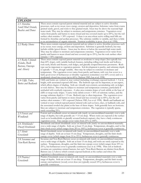
Table 5, cont.<br />
UPLANDS<br />
2.1 Shoreline<br />
Sand/Mud Strands,<br />
Beaches and Dunes<br />
These areas contain exposed parent mineral material and are subject to active shoreline<br />
processes, such as ice scour, wave energy, erosion and deposition. Substrate varies from coarse<br />
grained sands, gravel, and rocks to fine-grained muds. Areas may be above <strong>the</strong> seasonal high<br />
water mark. They may be subject to moisture and temperature extremes. Vegetation cover<br />
varies from patchy and barren to more closed and tree covered (rarely up to 60%), but <strong>the</strong> soil<br />
surface <strong>of</strong>ten remains > 50% exposed. A dune is an area where active rolling sand hills are<br />
formed by shoreline and aeolian processes. The substrate stability is variable, and <strong>the</strong>re is little<br />
to no accumulation <strong>of</strong> organic materials. Nutrient availability is poor. (Lee et al. 1998).<br />
2.2 Rocky Shores These areas contain exposed parent material and are subject to active shoreline processes such<br />
as ice scour, wave energy, erosion and deposition. Substrate is generally bedrock, but may<br />
include cobble/gravel shores. Areas may be above or below <strong>the</strong> seasonal high water mark.<br />
They may be subject to moisture and temperature extremes. Vegetation cover varies from<br />
patchy and barren to more closed and tree covered (up to 25%), but <strong>the</strong> rock surface <strong>of</strong>ten<br />
2.3 Rocky Uplands<br />
(Glades, Rock<br />
Barrens, Outcrops<br />
and Alvars)<br />
2.4 Cliffs, Talus,<br />
Buttes and Badlands<br />
2.5 Forests and<br />
Woodlands<br />
2.6 Shrublands/<br />
Dwarf-Shrublands<br />
2.7 Shrub<br />
Grasslands<br />
2.8 Savannas and<br />
Non-Rock Barrens<br />
2.9 Prairies/<br />
Grasslands<br />
remains > 50% exposed.<br />
These areas contain exposed parent material on moderate to steep slopes (but typically less<br />
than 60% slope), with variable bedrock features, including rolling rock knobs and hollows,<br />
rock reefs, blocks and fissures, rock ledges, and glacially scraped limestone pavements. Rock<br />
type can be important to vegetation patterns. Soil development is patchy, and substrate depth<br />
is typically < 15 cm, though variable. Sites may be subject to extremes in moisture and<br />
temperature. The vegetation cover varies from patchy and barren, with very low cover to a<br />
fairly good cover <strong>of</strong> herbaceous or shrubby vegetation (sometimes over 60% cover) and to a<br />
moderately closed tree cover (up to 60%) (Nelson 1985, Lee et al. 1998).<br />
Cliffs and buttes are vertical or near vertical (including overhangs) exposed bedrock > 3 m in<br />
height, with associated exposed cliff rims. The bedrock type can be important, as can aspect,<br />
which affects degree <strong>of</strong> shading. Soils are virtually non-existent, accumulating only on ledges<br />
or rock shelves. Sites may be subject to moisture and temperature extremes, particularly if<br />
unshaded with sou<strong>the</strong>rly exposures. A talus area contains slopes <strong>of</strong> rock rubble at <strong>the</strong> base <strong>of</strong><br />
cliffs or steep rocky slopes. Coarse rocky debris covers > 50% <strong>of</strong> substrate surface, and <strong>the</strong><br />
average substrate depth is < 15 cm. Bedrock type is <strong>of</strong>ten important. The vegetation cover<br />
varies from patchy and barren to more closed and tree covered (up to 60%), but <strong>the</strong> soil<br />
surface <strong>of</strong>ten remains > 50% exposed (Nelson 1985, Lee et al. 1998). Bluffs and badlands are<br />
vertical or near vertical exposed parent mineral soils such as loess, clays, or badlands soils, and<br />
<strong>the</strong> associated eroded clay plains at <strong>the</strong> base <strong>of</strong> <strong>the</strong>se slopes. Soils generally have no horizons.<br />
Sites are subject to moisture and temperature extremes. The vegetation is typically sparse,<br />
rarely exceeding 25%.<br />
Forests and woodlands occur on mineral soils (rarely on unconsolidated materials) over a wide<br />
range <strong>of</strong> depths, but soils generally are > 15 cm deep. Where rocks are exposed at <strong>the</strong> surface<br />
(such as in boulderfields or glacially scoured bedrock regions), <strong>the</strong>y have a fairly continuous<br />
vegetation cover. Tree canopy cover varies from 25% to 100%.<br />
Shrublands and dwarf-shrublands occur on mineral soils (rarely on unconsolidated materials)<br />
over a wide range <strong>of</strong> depths. Soils are at least 15 cm deep. Temperature, droughts, and/or fire<br />
limit shrub cover (which ranges from 25% to 100%); herbaceous cover is generally continuous.<br />
Shrub Grasslands occur on mineral soils (rarely on unconsolidated materials) over a wide<br />
range <strong>of</strong> depths. Soils are at least 15 cm deep. Temperature, droughts, and fire limit shrub<br />
canopy cover (which ranges from 10 to 25%), herbaceous cover is generally continuous.<br />
Savannas and Non-Rock Barrens occur on mineral soils (rarely on unconsolidated materials)<br />
over a wide range <strong>of</strong> depths. Soils are at least 15 cm deep, and rocks are rarely exposed at <strong>the</strong><br />
surface. Temperature, droughts, and fire limit tree canopy cover (which ranges from 10% to<br />
25%), but herbaceous cover is generally continuous (Lee et al. 1998). Thin soil or bedrock<br />
savannas are sometimes termed barrens, but such “Non-Rock Barrens are distinct from Rock<br />
Barrens (see 2.3 above) which contain exposed bedrock at <strong>the</strong> surface and where <strong>the</strong><br />
vegetation is discontinuous to sparse.<br />
Prairies/Grasslands occur on mineral soils (rarely on unconsolidated materials) over a wide<br />
range <strong>of</strong> depths. Soils are at least 15 cm deep. Temperature, droughts, and fire limit woody<br />
canopy encroachment (woody cover does not typically exceed 10%); herbaceous cover is<br />
generally continuous.<br />
PLANT COMMUNITIES OF THE MIDWEST – 2001<br />
23