Seafloor Imagery - Sidescan and Backscatter
Seafloor Imagery - Sidescan and Backscatter
Seafloor Imagery - Sidescan and Backscatter

Create successful ePaper yourself
Turn your PDF publications into a flip-book with our unique Google optimized e-Paper software.
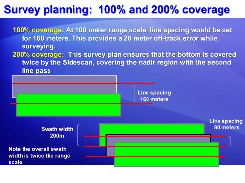
Survey planning: 100% <strong>and</strong> 200% coverage<br />
100% coverage: At 100 meter range scale, line spacing would be set<br />
for 160 meters. This provides a 20 meter off-track error while<br />
surveying.<br />
200% coverage: This survey plan ensures that the bottom is covered<br />
twice by the <strong>Sidescan</strong>, covering the nadir region with the second<br />
line pass<br />
Line spacing<br />
160 meters<br />
Swath width<br />
200m<br />
Line spacing<br />
80 meters<br />
Note the overall swath<br />
width is twice the range<br />
scale