Seafloor Imagery - Sidescan and Backscatter
Seafloor Imagery - Sidescan and Backscatter
Seafloor Imagery - Sidescan and Backscatter

You also want an ePaper? Increase the reach of your titles
YUMPU automatically turns print PDFs into web optimized ePapers that Google loves.
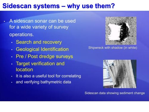
<strong>Sidescan</strong> systems – why use them<br />
• A sidescan sonar can be used<br />
for a wide variety of survey<br />
operations.<br />
• Search <strong>and</strong> recovery<br />
• Geological Identification<br />
• Pre / Post dredge surveys<br />
• Target verification <strong>and</strong><br />
location<br />
• It is also a useful tool for correlating<br />
• <strong>and</strong> verifying bathymetric data<br />
Shipwreck with shadow (in white)<br />
<strong>Sidescan</strong> data showing sediment change