Silver Jackets Quarterly Newsletter, January 2012 - Floodplain ...
Silver Jackets Quarterly Newsletter, January 2012 - Floodplain ...
Silver Jackets Quarterly Newsletter, January 2012 - Floodplain ...

Create successful ePaper yourself
Turn your PDF publications into a flip-book with our unique Google optimized e-Paper software.
www.nfrmp.us/state<br />
The purpose of this newsletter is to<br />
share recent <strong>Silver</strong> <strong>Jackets</strong> news and<br />
to provide a forum for team support,<br />
sharing successes, lessons learned, and<br />
resources.<br />
Contents<br />
Senior Leadership Support for <strong>Silver</strong><br />
<strong>Jackets</strong>.................................................1<br />
New Flood Risk Management Program<br />
Leader..................................................1<br />
Spot light on … <strong>Silver</strong> <strong>Jackets</strong><br />
Success in Minnewaukan, North<br />
Dakota..................................................2<br />
Don’t Let Lack of Charter Stop You:<br />
Hawaii 2060: Visioning Hawaii’s<br />
Adaptation to Climate Change...........3<br />
Arkansas Charter Demonstrates<br />
Teamwork............................................4<br />
Reevaluating the National Flood<br />
Insurance Program.............................5<br />
A Risk Informed Approach in the<br />
USACE Levee Safety Program...........6<br />
Natural Hazard Mitigation Association<br />
Practitioners<br />
Workshop............................................7<br />
Demonstrating Benefits of <strong>Silver</strong><br />
<strong>Jackets</strong> Pilot Projects.........................8<br />
FloodSmart Offers Tools and<br />
Resources to Help Communicate<br />
Flood Risk...........................................9<br />
National Flood Proofing Conference<br />
Field Trip............................................10<br />
<strong>2012</strong> Flood Risk Management-<strong>Silver</strong><br />
<strong>Jackets</strong> Annual Workshop: Let the<br />
Planning Begin!.................................11<br />
Useful Links.......................................11<br />
Upcoming Events..............................11<br />
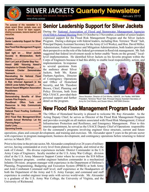
Senior Leadership Support for <strong>Silver</strong> <strong>Jackets</strong><br />
During the National Association of Flood and Stormwater Management Agencies<br />
(NAFSMA) Annual Meeting from 31 October to 3 November, a number of senior leaders<br />
expressed support for the Flood Risk Management Program and the <strong>Silver</strong> <strong>Jackets</strong><br />
Program. During a dialogue with federal leaders, including Hon. Terrence “Rock” Salt,<br />
Principal Deputy Assistant Secretary for the Army (Civil Works), and Hon. David Miller,<br />
Administrator, Federal Insurance and Mitigation Administration, both leaders provided<br />
their perspective on the role of the federal government in flood risk management. Mr. Salt<br />
suggested that federal involvement needs to better enable “boots on the ground,” locallevel<br />
implementation. He identified <strong>Silver</strong> <strong>Jackets</strong> as his favorite program within the<br />
Corps of Engineers because it had this ability to enable local responsibility, action, and<br />
implementation. In response<br />
to several questions from<br />
the audience about <strong>Silver</strong><br />
<strong>Jackets</strong>, both Ms. Karen<br />
Durham-Aguilera, Director<br />
of Contingency Operations<br />
and Office of Homeland<br />
Security, and Mr. Theodore<br />
Brown, Chief, Planning and<br />
Policy Division, both from<br />
HQs USACE, provided their<br />
personal support and further<br />
detail on the program.<br />
New Flood Risk Management Program Leader<br />
The Office of Homeland Security is pleased to welcome Mr. Ray Alexander. As the<br />
Acting Deputy Chief, he serves as Director of the Flood Risk Management Program<br />
and provides oversight on all matters associated with Flood Risk Management, Critical<br />
Infrastructure Protection and Resilience, and Emergency Management. Prior to this<br />
interim appointment, he served as the USACE Deputy Chief of Operations responsible<br />
for the command’s programs involving engineer force structure, current and future<br />
operations, plans and concept development, and training and exercises. Mr. Alexander spent 5 years in the private sector<br />
with experience in program management, business development, and contingency operations before returning to federal<br />
service in March 2011.<br />
Prior to his time in the private sector, Mr. Alexander completed over 26 years of military<br />
service, having commanded at every level from platoon to brigade, and retired at the<br />
rank of Colonel. His diverse experiences include: District Commander in the U.S<br />
Army Corps of Engineers; faculty member at the U.S. Army War College; division<br />
chief at the U.S. Army Maneuver Support Center where he oversaw the $18 billion<br />
Army Engineer program; combat engineer battalion commander in a mechanized<br />
Infantry Division; program manager with experience in the Department of Defense’s<br />
Planning, Programming, Budgeting and Execution System (PPBES) at both Army<br />
and Joint Combatant Command staff level; staff experience at the Headquarters of<br />
both the Department of the Army and U.S. Army Europe; and command and staff<br />
experience in combat engineer troop units with service world-wide. Mr. Alexander<br />
is a graduate of the U.S. Army War College, the University of Virginia, and the<br />
University of Richmond.<br />
1<br />
Steve Stockton, Director of Civil Works, USACE, Jim Fiedler, NAFSMA<br />
President, Terrence "Rock" Salt, Principal Deputy Assistant Secretary of<br />
Army for Civil Works, and Susan Gilson, NAFSMA Director.
<strong>Silver</strong> <strong>Jackets</strong> <strong>Quarterly</strong> <strong>Newsletter</strong><br />
Spot light on …<br />
<strong>Silver</strong> <strong>Jackets</strong> Success in Minnewaukan, North Dakota<br />
By Terry Zien, USACE St. Paul District and Michael Hall, ND DES<br />
2<br />
<strong>January</strong> <strong>2012</strong><br />
The City of Minnewaukan has a population of 320 and is located eight miles from Devils Lake. The lake, supported<br />
by a 3800 square miles watershed, is a closed basin and has risen 30 feet in the past 20 years causing serious flooding<br />
problems for the city and surrounding area. In the spring of 2010, the ND <strong>Silver</strong> <strong>Jackets</strong> Team engaged in discussions<br />
with the ND Water Commission Department of Emergency Services (DES) and the city due to the continual threat of<br />
rising water inundating the city on three sides. The flooding crisis was intensified due to the threat to a public school and<br />
city water tower.<br />
Although a reconnaissance study was completed in 2003 that provided a number of potential alternatives to mitigate the<br />
effects of the rising lake level, the city was in need of a current review of options and a decision tool to reach consensus on<br />
the best approach and the way ahead. The trust and relationships developed through the <strong>Silver</strong> <strong>Jackets</strong> Team allowed the<br />
federal and state partners to quickly come together to formulate a course of action. The city served as the local sponsor of<br />
a Planning Assistance to States study from the USACE with local cost share provided by DES. The cost share agreement<br />
was signed in June 2010 and the resulting report was completed in September 2010.<br />
The study supported an intensive interagency effort to evaluate alternatives for flood risk reduction for the City of<br />
Minnewaukan and provide recommendations as to which alternatives or combination of alternatives seem viable for<br />
a long term solution. In developing the report, several focus meetings were held to gather information and testimony<br />
from local and state officials for recommendations on<br />
actions to assist with the flooding problems. Several<br />
options were identified to step down flood risks,<br />
including structural and non-structural solutions, that<br />
were supported by multiple federal authorities. The<br />
study report served as an important decision tool to<br />
help the city understand their remaining viable options<br />
for flood risk mitigation.<br />
In the last few years, several homes and a church<br />
have been bought out or relocated. In 2011, the city<br />
requested St. Paul District USACE build a temporary<br />
emergency levee around the eastern edge of town<br />
to provide immediate protection from the lake and<br />
allow enough time to build a new school and identify<br />
a location for a new water tower. The Minnewaukan<br />
School District was a key player in working with<br />
the city and purchased 45 acres of land about a mile Devils Lake encroaching on Minnewaukan, ND<br />
northwest of Minnewaukan. This parcel of land is on high ground not threatened by the lake, and the school and water<br />
tower will be located there. An application was submitted to FEMA for the acquisition of an additional 90 homes. Some<br />
of these residents have indicated that they would be interested in moving to a new development if it were supported and<br />
purchased by the city. The core of the downtown business area, including the historic county seat, is at an elevation above<br />
expected impacts from the rising lake. Pending the results of an environmental assessment, the water tower and sanitation<br />
sewer upgrades to support both the new development and the city will begin soon.<br />
The City of Minnewaukan faces many tasks to complete their largely non-structural flood risk mitigation plan. Funding for<br />
these projects includes a combination of federal, state, and local loans and grants, resulting in a patchwork quilt solution,<br />
with some funding sources still being identified. The cooperation and collaboration enabled by the trust and relationships<br />
formed through the <strong>Silver</strong> <strong>Jackets</strong> Team have provided a path forward and will continue to be a source of support in the<br />
years to come. The ongoing efforts to relocate a large number of people, their vital institutions, and infrastructure serve<br />
as an important example of what can be accomplished when citizens and different levels of government come together to<br />
provide a shared vision and solutions to our nation’s flood risk problems.
<strong>Silver</strong> <strong>Jackets</strong> <strong>Quarterly</strong> <strong>Newsletter</strong><br />
Don’t Let Lack of Charter Stop You:<br />
3<br />
<strong>January</strong> <strong>2012</strong><br />
Hawaii 2060: Visioning Hawaii’s Adaptation to Climate Change<br />
By Cindy Barger, USACE<br />
In August 2011, Honolulu District’s <strong>Silver</strong> <strong>Jackets</strong> initiative, the State of Hawaii‘s Coastal Zone Management Program,<br />
and the National Oceanic and Atmospheric Administration sponsored a workshop to facilitate the development of a<br />
statewide climate change policy. Sixty participants engaged in a unique futures approach to policy development.<br />
The participants represented a wide array of interests including federal, state and county agencies, academia, Native<br />
Hawaiians, environmental non-profits, community organizations, business associates, insurance companies, and youth.<br />
The workshop resulted in the development of priority guidelines for climate change adaptation being proposed by the<br />
Governor of Hawaii as an addition to the Hawaii State Planning Act in the <strong>2012</strong> State Legislative Session.<br />
"Strategies for adapting to the adverse impacts of climate change require a multi-disciplinary, integrated planning approach<br />
that takes into account other stressors such as population growth, economic realities, and Peak Oil. The futures exercise,<br />
sponsored by <strong>Silver</strong> <strong>Jackets</strong>, allowed diverse stakeholders to experience these futures together, which stimulated more<br />
comprehensive strategies to address future climate change impacts," stated Mr. Jesse Souki, Director of Hawaii’s Office<br />
of Planning and co-sponsor of the workshop.<br />
Participants were transported into the year 2060 and experienced four different scenarios based on futures archetypes of<br />
continued growth, disciplined, collapsed, and transformed societies. The participants were asked to “live” within these<br />
scenarios, accepting them as their reality and evaluating the pros and cons. Based on their experiences, they developed<br />
a “preferred future” centered on aspects of the scenarios they wished to retain or control against. This creative process<br />
encourages participants to think “outside of the box” in developing policies.<br />
Day two applied the “appreciative inquiry” process to identify the policy and actions needed to foster the “preferred<br />
future”. Participants worked together to conduct an “environmental scan” of the trends, stakeholders, contributors,<br />
and competitors that may influence the development and implementation of the “preferred future” and climate change<br />
adaptation policy. Participants developed a climate change adaption “vision” built on shared values that formed the<br />
primary basis for the final climate change policy submitted. The workshop concluded with the identification of two<br />
priority strategic issues and associated action plans: (1) Educated Public and Political Will and (2) Integrated Planning<br />
and Collaboration.<br />
Captain Jim Coon, the Maui Island representative for the Marine and Coastal Advocacy Council, stated, “This workshop<br />
was one of the most effective I have ever attended. The effort that went into creating the four different scenarios of<br />
life in 2060 paid off as we let ourselves<br />
live within the scenario. I believe that the<br />
vision that was cast was far more effective<br />
and realistic because of that effort. Finally<br />
the outcome was one that could be<br />
presented and defended to our legislators to<br />
guide them in their promulgation of climate<br />
change policy which will determine how<br />
the State of Hawaii and its people plan<br />
most effectively for climate change.”<br />
"The two-day workshop allowed leaders<br />
to develop a shared understanding of the<br />
inevitable impacts of climate change in<br />
Hawaii along with a common foundation<br />
for the future we would like to see for<br />
Hawaii's people, systems, businesses, and<br />
resources," said Mark Fox, External Affairs<br />
Director for The Nature Conservancy's<br />
Workshop participants defining shared values that will form a climate change vision statement. Hawaii Program.
<strong>Silver</strong> <strong>Jackets</strong> <strong>Quarterly</strong> <strong>Newsletter</strong><br />
Arkansas Charter Demonstrates Teamwork<br />
<strong>January</strong> <strong>2012</strong><br />
On <strong>January</strong> 24th, the Arkansas <strong>Silver</strong> <strong>Jackets</strong> Team held their official team charter signing ceremony. Their vision<br />
is to increase efficiency and coordination between the state and federal governments in developing comprehensive<br />
and sustainable solutions to flood risk management for the State of Arkansas. Col. Jeffrey Eckstein, Commander of<br />
USACE Vicksburg District, stated, “As our budgets for everyone continue to get reduced, this kind of cooperation and<br />
communication framework that we have with the <strong>Silver</strong> <strong>Jackets</strong> will help us see solutions out there that we might not<br />
normally see without the teamwork and coordination. ”<br />
Prior to the formal signing of the team charter, the Arkansas <strong>Silver</strong> <strong>Jackets</strong> team has been actively pursuing solutions<br />
to the state’s flood risk issues. They are currently using resources from USACE, FEMA, Arkansas Natural Resources<br />
Commission, and USGS to analyze and document the April/May flood event of 2011 for the White, Black, Cache, and<br />
St. Francis Rivers in Arkansas.<br />
Signatories - (Left to Right) Randy Young (ANRC), David Maxwell (ADEM), Colonel Glen Masset (USACE Little Rock), Tony Robinson (FEMA), Lt. Colonel Daniel<br />
Hamilton (USACE Memphis), Colonel Jeffrey Eckstein (USACE Vicksburg not pictured)<br />
Arkansas <strong>Silver</strong> <strong>Jackets</strong> Team - (Front Row Left to Right) - Donna Ryles (ANRC), Theresa Lear (ADEM), Jaysson Funkhouser (USGS) (Second Row Left to Right)<br />
Mike Borengasser (ANRC), Don Davenport (USACE Memphis), Josh Rogers (ADEM), Chad Dulaney (USACE Little Rock), Ronald Wanhanen (FEMA) (Not pictured)<br />
- Guy Lowes (FEMA), Katy Breaux (USACE Vicksburg), Tony Hill (USACE Little Rock), Elmo Webb (Little Rock District)<br />
4
<strong>Silver</strong> <strong>Jackets</strong> <strong>Quarterly</strong> <strong>Newsletter</strong><br />
Reevaluating the National Flood Insurance Program<br />
By Laurie Smith-Kuypers, FEMA<br />
<strong>January</strong> <strong>2012</strong><br />
Congress established the National Flood Insurance Program (NFIP) in 1968 to develop and sustain a more comprehensive<br />
approach to flood risk management. Although the program has evolved through the years, the fundamental concept of the<br />
NFIP remains unchanged. This is why in the upcoming months the Federal Emergency Management Agency’s NFIP will<br />
be considering a long-awaited and carefully designed transformation.<br />
After more than a decade of seeking input, identifying issues, and conducting studies, FEMA is winding down a critical<br />
review of the NFIP. The official review began in November 2009, with the formation of a “Working Group” consisting of<br />
a cross-section of NFIP staff. Reform is never fast or easy, but this group of individuals came together to review, rethink,<br />
and reform the NFIP.<br />
“FEMA has done an incredible job of leading<br />
an unprecedented initiative to seek input from<br />
stakeholders from across the spectrum of those<br />
involved or affected by the NFIP,” said FEMA<br />
Deputy Associate Administrator of Mitigation,<br />
Sandra K. Knight. “The level of support and<br />
commitment from the agency to solicit input<br />
on the program and examine the changes that<br />
have been recommended, both internally and<br />
externally, has been remarkable.”<br />
In its reform efforts, FEMA is looking to<br />
address hot issues in the near term, while, at<br />
the same time, tackling some of the more longterm<br />
financial and programmatic guidance for<br />
a successful program. The end result should<br />
be a fiscally sound program that reduces flood<br />
hazard vulnerability by successfully utilizing<br />
programs that offer affordable flood insurance<br />
and encourage sound floodplain management<br />
practices.<br />
Congress originally authorized the NFIP to offset the cost of flooding events, which are this county’s most expensive<br />
natural disaster. The program was established to offer property owners a viable way to recover quickly from the economic<br />
impacts of flood events. The program also set out to educate communities about reducing their flood risk through the<br />
adoption and enforcement of local floodplain management regulations. Finally, in order to reduce and manage risk,<br />
Congress realized that flood hazards had to be identified through mapping and engineering studies.<br />
The Working Group’s “roadmap” for reform continues to be based on the belief that private individuals and local<br />
communities bear a responsibility to protect themselves from flood hazards. Yet, it also recognizes that government<br />
has a responsibility to ensure that its citizenry has access to the tools necessary to do so, including accurate flood risk<br />
information, affordable flood insurance, and effective floodplain management guidance.<br />
Throughout the reform efforts, FEMA has kept key stakeholders apprised of its progress, while addressing issues of<br />
immediate concern and establishing a solid foundation for the NFIP’s future. The Working Group has spent the last two<br />
years combing through analyses, Government Accountability Office reports, and other sources of input to come to its<br />
improvement recommendations. The team put forth a combination of accepted best practices, “hot” button issues, and<br />
ways to incrementally change and improve long-term policy direction. The entire process was divided into three phases:<br />
listening session and analyses, developing and weighting criteria, and evaluating practical policy alternatives.<br />
The Working Group has recently completed its final phase and delivered its draft recommendations to FEMA leadership.<br />
The “roadmap to reform” will soon be vetted with the Administration and released. Ultimately, the solution will be used<br />
to implement internal policy changes in the NFIP and help support future legislation.<br />
5
<strong>Silver</strong> <strong>Jackets</strong> <strong>Quarterly</strong> <strong>Newsletter</strong><br />
6<br />
<strong>January</strong> <strong>2012</strong><br />
A Risk Informed Approach in the USACE Levee Safety Program<br />
Like the Dam Safety Program, the Levee Safety Program uses a risk-informed approach to understand and ascertain the<br />
best decisions about the portfolio of over 2,000 levee systems for which USACE has responsibilities. In risk-informed<br />
decision making, the risk (likelihood and consequences) of potential inundation of floodplain properties and occupants<br />
that may be associated with the presence of a USACE levee system is assessed and used to supplement historic practices<br />
of standards-based decisions. With this approach, USACE can then identify levee safety issues, assess the inundation<br />
risk, identify risk management options, and use this information to justify and prioritize the urgency of risk management<br />
decisions.<br />
Central to this approach is how the inundation risk is assessed and quantified. Several questions need to be asked during<br />
this assessment. What is the range of possible undesirable events (flood, storm or earthquake, etc.) How will the<br />
infrastructure perform in the face of these events What are the consequences if the infrastructure doesn't perform well<br />
with loss of life of paramount concern In other words, what are the likelihood and severity of undesirable or adverse<br />
consequences<br />
A successful safety program uses periodic and continuous assessments and inspections to inform risk management<br />
decisions. The screening level assessments take the next step beyond the routine annual and periodic inspection. It<br />
actually uses information from these routine levee safety activities.<br />
The screening level assessment uses the following information in the context of the risk definition above:<br />
• available information from completed inspections<br />
• design and construction records<br />
• a limited engineering assessment and other studies<br />
• observations regarding performance of the levee system<br />
• life safety, economic, and environmental consequences<br />
USACE uses software developed for the levee safety program entitled "Levee Screening Tool" to assist in performing the<br />
screening level assessment. They have plans to screen its entire portfolio of levees to identify the highest risk systems<br />
first and then implement risk management decisions in such a way as to more efficiently reduce risk across the entire<br />
portfolio.<br />
The screening level assessment results inform the Levee Safety Action Classification (LSAC). It is important to note<br />
that the LSAC is not a rating. It does not supplant inspections nor constitute a levee system evaluation for the NFIP, nor<br />
is it to be used to de-accredit a levee in the NFIP. The LSAC emphasizes the risks associated with the levee system’s<br />
performance and consequences of potentially poor performance - as it presently exists (from the floodplain occupant<br />
perspective). The result is a preliminary, relative estimate of inundation risk associated with the presence of a levee<br />
system, which characterizes risk, determines next steps and urgency, prioritizes investments, and justifies actions to<br />
manage risk. It emphasizes life-safety risk first, while considering economic and environmental risk.<br />
In making the LSAC assignment, USACE considers the incremental<br />
risk, which is defined as the inundation risk to floodplain occupants<br />
and properties that may arise due to the presence of a USACE levee<br />
system that may not perform as intended. This risk is estimated<br />
for the following inundation scenarios: levee breach prior to<br />
overtopping, levee breach after overtopping, system component<br />
malfunction, or misoperation.<br />
However, an additional potential inundation scenario exists: the<br />
levee functions as intended under normal operation, but may<br />
experience overtopping without breach (no-breach risk) for<br />
events that exceed the containment capacity. No-breach risk<br />
and incremental risk equals residual risk, which is also assessed,<br />
emphasizing that levees do not completely eliminate inundation<br />
risk - an important aspect of levee safety programs.
<strong>Silver</strong> <strong>Jackets</strong> <strong>Quarterly</strong> <strong>Newsletter</strong><br />
7<br />
<strong>January</strong> <strong>2012</strong><br />
Natural Hazard Mitigation Association Practitioners Workshop<br />
By Ann Patton, NHMA<br />
Unprecedented currents of change are creating a “perfect storm” of challenges for disaster fighters in at least three<br />
areas: demography, climate, and economy. If we want to reduce losses that continue to spiral out of control, we must<br />
make dramatic changes in how we operate. We have to find new ways to work together holistically and create resilient<br />
communities from the bottom up. This was the urgent message from experts and front-line workers who attended the<br />
2nd annual National Hazard-Mitigation Practitioners Workshop, “Mitigation on the Ground”, last July. The National<br />
Hazards Mitigation Association (NHMA) sponsored the meeting as an add-on to the Natural Hazards Center’s summer<br />
Colorado workshop. Speakers said trends are converging to bring rapid changes to the nation’s demographics, climate,<br />
and economy, making us more vulnerable to disasters.<br />
Demographics<br />
The face of the nation is changing rapidly with vast implications for disaster policies, said demographer Steve Murdock,<br />
former director of the U.S. Census. Minorities account for 92 percent of U.S. growth, as the nation’s middle class is<br />
eroding and the number of poor and under-educated is rising. These populations are the least able to prepare for and<br />
manage disasters, in part because they are consumed with day-to-day survival. Yet most education and outreach target<br />
the middle-class.<br />
Climate<br />
We’re breaking all records for natural disasters across all continents said NOAA’s Margaret Davidson. “The trends and<br />
cycles we are seeing are not like anything we have seen in history.”<br />
Economy<br />
The economy is in crisis, and distrust of government abounds. We cannot expect to free up new capital largess. The scope<br />
and frequency of disasters make big-government management problematic. “Nobody has any money now,” said Bill<br />
Becker of Natural Capital Solutions, “and we are apt to see programs cut, not started. All pollution is global, but localities<br />
will have to control their own destinies.” We must focus on building smarter and safer said FEMA’s Sandra Knight.<br />
Creative partnerships are more important than ever, demanding that organizations like NHMA bring together diverse and<br />
untapped champions for hazard mitigation.<br />
Taken together, what these trends mean, said University of Colorado’s Dennis<br />
Mileti, is that, despite everything you or your agency have done, things<br />
will continue to get worse unless we change our approach. The climate is<br />
changing, we live in an era of “capitalistic globalization,” and the middle<br />
class is gone. We are swimming upstream against overwhelming odds if we<br />
fail to attack mitigation holistically and don’t see it in the context of the time.<br />
“Mitigation happens when you change the culture and value thinking in the<br />
long term,” Mileti said. “Mitigation spreads when people talk to each other.<br />
We once had a program in America to do just that, Project Impact, and we<br />
would be wise to bring it back – not necessarily by that name, but showing<br />
how mitigation can occur in a community when locals come to value it. We<br />
need to get the conversation going in America’s communities and get people<br />
talking to each other. It worked before, and it can happen again.”<br />
Ed Thomas, NHMA President, urged the group to take the words “natural disaster” out of their vocabularies when they<br />
refer to damaging events. “There is no such thing,” Thomas said. “We need to remember what Gilbert White taught us:<br />
While hazards such as floods, wildfires, and earthquakes are acts of God, disasters are largely acts of men.”<br />
The American Meteorological Society’s Bill Hooke, chairman of the NHMA Advisory Committee, said even though the<br />
problems look too big to solve, we can take hope from recent advances in aviation and population control. The aviation<br />
industry learned from experience and dramatically sliced its accident rate. A few years ago people thought population was<br />
headed for 15 billion at hopelessly unsustainable rates; but, through outreach and policy changes, the birth rate dropped<br />
significantly. Hooke said we now need to attack disaster mitigation with things that are fast, cheap, effective, based on<br />
facts, and scalable so communities can utilize them.
<strong>Silver</strong> <strong>Jackets</strong> <strong>Quarterly</strong> <strong>Newsletter</strong><br />
Among many successful models cited were:<br />
<strong>January</strong> <strong>2012</strong><br />
• The <strong>Silver</strong> <strong>Jackets</strong> program of the U.S. Army Corps of Engineers, which is helping<br />
develop a more holistic vision for mitigation.<br />
• FEMA’s Risk MAP (Mapping, Assessment, and Planning) program, described by FEMA’s<br />
Roy Wright as an opportunity to reduce the impact of disasters by making programs more<br />
usable for local communities.<br />
• The Federal Alliance for Safe Homes (FLASH) is proving that mitigation is good<br />
business by building partnerships to bring mitigation to the public, said Leslie Chapman-<br />
Henderson, who heads FLASH as well as the International Code Council’s foundation.<br />
Henderson described the 2,700-square-foot FLASH exhibit at Disney World named<br />
StormStruck®: A Tale of Two Cities, which takes visitors through a perfect storm to Roy Wright, FEMA<br />
help them better know their risks, understand their options, and feel empowered to take action.<br />
NHMA is developing a proposed cooperative venture tentatively named NeighborNet to link together grassroots<br />
communities working on mitigation, disaster recovery planning, and resilience. The first local pilot using the NeighborNet<br />
concept to coordinate community planning and preparedness is Tulsa Partners, a corporate member of NHMA.<br />
Proceedings of the 2011 Practitioners Workshop, including video of speakers and their presentations, are available at www.<br />
NHMA.info; the next NHMA Practitioners Workshop is planned for July <strong>2012</strong> in Broomfield, CO. NHMA membership<br />
is open to all who support hazard mitigation.<br />
Demonstrating Benefits of <strong>Silver</strong> <strong>Jackets</strong> Pilot Projects<br />
Background<br />
The U.S. Army Corps of Engineers initiated 12 <strong>Silver</strong> <strong>Jackets</strong> pilot projects totaling $1.14 million in Fiscal Year 2011.<br />
The pilot projects, which were coordinated through state <strong>Silver</strong> <strong>Jackets</strong> teams, help illustrate the benefits of inter-agency<br />
approaches, leveraging resources with partners, and flood risk reduction. A total of 35 proposals were received from 22<br />
states requesting over $4 million. Additional projects are being considered for Fiscal Year <strong>2012</strong> funding.<br />
Demonstrating Project Benefits<br />
Each team selected for funding in Fiscal Year 2011, participated in a discussion of how the teams will quantify project<br />
benefits. Economic experts from the Institute of Water Resources and the Flood Risk Management Center of Expertise<br />
joined the calls and offered their assistance. The desired result to be achieved by the projects’ completion is thoughtful<br />
documentation of project benefits: ideally, quantifiable benefits that will paint a compelling picture of the actions taken,<br />
the flood risks reduced, and the dollars saved (including future obligations) because of the projects. Results will be<br />
helpful both within and outside the flood risk management community to demonstrate the benefits achieved for the<br />
investment made and to set the stage for future projects.<br />
Observations from the initial coordination calls are as follows:<br />
• There is general recognition of the value of the effort and willingness to seek ways to quantify benefits, with the<br />
understanding that the effort is necessarily commensurate with the scope of the project and the funding provided.<br />
• Quantifying reduced risks is not easy, particularly when the project focus is on the provision of information and<br />
when actions will be by others such as residents and community officials.<br />
• No single methodology or measure is being promoted or will apply for all pilot projects.<br />
• A wide-range of potential measureable benefits were discussed including: increased warning time, reduced life<br />
risk, increased access to information, increased audience receiving information, less risky emergency operations,<br />
reduced hours invested in emergency evacuation, increased community credit and/or reduced insurance premium<br />
costs through the Community Rating System, reduced disaster payouts through the National Flood Insurance<br />
Program, reduced disaster damages, and reduced future expenditures.<br />
• Nearly all projects entail significant leveraging of resources that will be documented.<br />
• Where important benefits cannot be quantified, teams will provide descriptions that “tell the story” of the benefits<br />
in reducing flood risk. These descriptions are intended to enhance, rather than replace, the focus on quantification.<br />
Funding for additional pilot projects will be awarded on an ongoing basis. Please work with your <strong>Silver</strong> <strong>Jackets</strong> teams to<br />
develop and submit additional proposals at any time.<br />
8
<strong>Silver</strong> <strong>Jackets</strong> <strong>Quarterly</strong> <strong>Newsletter</strong><br />
FloodSmart Offers Tools and Resources to Help<br />
Communicate Flood Risk<br />
By Bruce Bender, FloodSmart<br />
9<br />
<strong>January</strong> <strong>2012</strong><br />
As <strong>Silver</strong> Jacket teams progress with leveraging multiple agency resources to implement sound flood risk management,<br />
helping property owners understand their flood risk and getting them to take action to reduce it remains an ongoing<br />
challenge. Many citizens are not convinced that they could be susceptible to flooding due to misperceptions and<br />
miscommunications surrounding why they are at risk and what the financial implications are if they do flood.<br />
Through FloodSmart, the National Flood Insurance Program’s (NFIP) national marketing campaign, a variety of webbased<br />
tools and resources have been developed to help stakeholders, such as floodplain managers and other state and<br />
community officials, communicate flood risk. These tools and resources on FloodSmart.gov can help stakeholders<br />
better explain a community's flood risks and recommended actions, including flood insurance, to reduce the devastating<br />
consequences of flooding.<br />
The FloodSmart website has several tools that can be downloaded, shared or posted on community websites for use by<br />
citizens. These tools help bring the flood story to life for residents and business owners. The shareable tools include:<br />
• Flood Risk Scenarios -- This online tool illustrates common causes of flooding through animated scenarios.<br />
Users can click on a scenario to see examples of how and why it can flood.<br />
• Cost_of_Flooding -- Users can interact with this tool by choosing how deep the flood waters could<br />
be in a home. This tool shows that all it takes is a few inches of water to cause major damage to<br />
a home and its contents. It is an excellent way to illustrate the financial consequences of a flood.<br />
• Widgets -- During the year, FloodSmart creates and updates widgets as an interactive way to educate individuals about<br />
the risks of flooding and direct them to where they can learn more. Widgets have been created for a variety of seasons,<br />
including winter flooding and hurricane season. These and other widgets are available from FEMA's widget page.<br />
• Levee_Simulator -- This online educational tool helps explain in simple terms how levees work and<br />
how they can fail. Using illustrated scenarios, users can see different ways that a levee can fail (seepage,<br />
breaching) and overtop. It also offers tips on how property owners can mitigate against damage.<br />
• Testimonial -- Online videos from people who have experienced flooding provide compelling, first-hand accounts<br />
of the consequences of flooding. These testimonials describe floods that occurred in different parts of the nation<br />
from a number of sources, including coastal storms and levee failures. They include home and business owners<br />
who did and did not have flood insurance.<br />
FloodSmart has also developed a series of toolkits that<br />
community officials can use to promote flood insurance,<br />
to assist in communicating the changes in flood risk due to<br />
map changes, and to address levee issues. The mapping<br />
and levee toolkits contain template outreach materials and<br />
letters designed for communities to customize and use in<br />
local outreach. There is also a Spanish language toolkit for<br />
communities with Spanish-speaking populations. The toolkits<br />
are available for immediate use at FloodSmart.gov/toolkits.<br />
<strong>Silver</strong> Jacket teams are an important resource in helping local<br />
citizens to better understand the risks and steps that can be<br />
taken to address them. For more information about using and<br />
downloading these tools to other sites, contact FloodSmart at<br />
info@femafloodsmart.com.
<strong>Silver</strong> <strong>Jackets</strong> <strong>Quarterly</strong> <strong>Newsletter</strong><br />
National Flood Proofing Conference Field Trip<br />
By Judy Soutiere, USACE Sacramento District<br />
<strong>January</strong> <strong>2012</strong><br />
The National Flood Proofing Conference held in Sacramento, CA, from November 28th to December 1st, culminated<br />
with a field trip to two sites: the challenging Natomas leveed area, and Roseville, which is the first community to achieve<br />
a Class 1 designation in the NFIP Community Rating System (CRS). Natomas, a large section of land with over 55,000<br />
acres, is surrounded by 42 miles of weak levees on the north side of Sacramento, making it one of the most at risk areas in<br />
the nation. For many years, the FEMA flood maps showed the area as protected so no floodplain management regulation<br />
or flood insurance was required. However, re-examinations indicate that the Natomas levee system, originally built as an<br />
agricultural levee, is not adequate to protect to the 100-year flood. As a result, the area has been remapped as a Special<br />
Flood Hazard Area, making flood insurance and regulation required. The field trip participants observed the implication<br />
of these requirements firsthand while visiting the new city fire station within the area. The station was built to meet the<br />
flood standards with the base floor elevation approximately 20 feet high. All electricity for the bottom floor is totally<br />
separate from the upper floor and is built with flood vents to allow water to pass through the buildings. The work required<br />
to reduce the risk of flooding in the leveed area is complex and costly. The participants learned what is still needed to<br />
be done to reduce the risk and fix the levees. Eighteen miles of the levee system have been rebuilt with local funding to<br />
meet the 100-year standards. The state, USACE, and the Sacramento Area Flood Control Agency have been working on<br />
a solution for the remaining portions of the system.<br />
Not far away is Roseville, which has a population of over 100,000 and is 15 miles northeast of Sacramento. The city is<br />
located within portions of two major drainage basins that eventually empty into the Sacramento and American Rivers.<br />
Damaging floods have occurred roughly every 3 to 5 years with the two largest recorded events in 1986 when 209<br />
structures flooded and 1995 when 358 structures flooded. Roseville has responded aggressively to avert future serious<br />
flooding. The city implemented a multi-year flood control improvement strategy including detention basins, buying out<br />
repetitive-loss properties, elevating buildings at risk, excavating channels, replacing culverts, and constructing berms<br />
and floodwalls. In addition, Roseville installed an early warning system with 18 rain and 19 stream gages connected to a<br />
computer monitoring system. The city relies on a wide-range of activities to protect the residents from flooding. These<br />
include open space preservation, 2 feet of freeboard in and near the floodplain, strong building codes, and an all hazards,<br />
pre-disaster mitigation plan. In fact, Roseville receives CRS points in 16 of the 18 floodplain management activities<br />
which entitle the residents to a 45% reduction in flood insurance premiums. During the field trip it was noted that no<br />
structure built after 1980 has incurred flooding. In addition, the National Weather Service has designated Roseville as a<br />
StormReady Community. For more information about these field trip observations and Roseville's floodplain management<br />
strategies, check out the web link.<br />
Connie Perkins points to high water mark in the<br />
City of Roseville<br />
Natomas Fire station that has the second floor elevated above BFE.<br />
10
<strong>Silver</strong> <strong>Jackets</strong> <strong>Quarterly</strong> <strong>Newsletter</strong><br />
<strong>January</strong> <strong>2012</strong><br />
<strong>2012</strong> Flood Risk Management-<strong>Silver</strong> <strong>Jackets</strong> Annual<br />
Workshop: Let the Planning Begin!<br />
Following the highly rated 2011 Flood Risk Management-<strong>Silver</strong> <strong>Jackets</strong><br />
Annual Workshop, energy to plan the <strong>2012</strong> workshop is running high.<br />
Reflecting our commitment to an interagency, state-focused event,<br />
representatives from at least seven state <strong>Silver</strong> <strong>Jackets</strong> teams and four<br />
partner federal agencies make up the planning advisory committee.<br />
First on the agenda are the call for abstracts, training and information<br />
session needs, and nominations for Flood Risk Management and <strong>Silver</strong><br />
<strong>Jackets</strong> individual and team awards. Beginning in February, updates will<br />
be posted to the workshop website www.nfrmp.us/frmpw. Please take<br />
advantage of the opportunity to submit an abstract to share your story,<br />
help the planning committee design a workshop that will fit your needs,<br />
and, of course, nominate that previously unrecognized, but dedicated,<br />
team or individual who has moved us forward in managing flood risk.<br />
Useful Links<br />
Pending approval, the Workshop is scheduled for 20-24 August in<br />
Harrisburg, Pennsylvania.<br />
Low Impact Development: At the Nashville Workshop, Ms. Lisa Hair from USEPA explained the Low Impact<br />
Development (LID) approach which EPA promotes for environmental protection and which also has benefits for<br />
flood reduction. LID reduces the volume of runoff after storms by capturing runoff from small storms at the source<br />
and either infiltrating it or otherwise using the first inch or two. Communities that use Low Impact Development<br />
are finding that it is cheaper, reduces flooding issues, and can reduce contamination. An article on the topic in the<br />
Nov/Dec 2011 issue of Stormwater, a journal for surface water quality professionals, is now out and is available<br />
online.<br />
New <strong>Silver</strong> <strong>Jackets</strong> Tri-Fold: There is something reassuring and official about holding a brochure. It provides a<br />
lasting impression long after the presentation is over. Each agency has outreach opportunities that <strong>Silver</strong> <strong>Jackets</strong><br />
can capitalize on with the right tools. The Virginia <strong>Silver</strong> <strong>Jackets</strong> set off to create just such a tool with two goals in<br />
mind: develop an outreach tool to be distributed by team members and their organizations in digital or hard copy<br />
form and develop a model that any <strong>Silver</strong> <strong>Jackets</strong> team could modify and use.<br />
"This brochure clearly explains what the <strong>Silver</strong> <strong>Jackets</strong> Team is all about and how we can help communities<br />
struggling with repetitive losses due to flooding. I will be happy to distribute it at NWS outreach events," said Patti<br />
Wnek, Service Coordination Hydrologist, NOAA, NWS, Middle Atlantic River Forecast Center.<br />
Upcoming Events<br />
March<br />
• Virginia Lakes and Watershed Conference / Virginia <strong>Floodplain</strong> Manager's Association Conference, Richmond,<br />
VA, March 4 - 6, <strong>2012</strong>.<br />
• Region X Regional Interagency Steering Committee (RISC) Geospatial Subcommittee meeting, Boise, ID, March<br />
20. HAZUS Training (tentative) to follow, March 21-23<br />
• USACE Learning Center Course 345 on Non-Structural Measures for Flood Risk, Reno-Sparks, NV, March 26-<br />
30, <strong>2012</strong>. Participants will become familiar with the opportunities of nonstructural measures including how to<br />
formulate and implement them.<br />
May<br />
• Association of State <strong>Floodplain</strong> Management 36th Annual National Conference “Mission Mitigation”, San<br />
Antonio, TX, May 20-25.<br />
11
THE VIRGINIA<br />
SILVER JACKETS TEAM<br />
A team of individuals from both federal and state<br />
agencies that come together to facilitate<br />
collaboration, share information, and leverage<br />
resources to identify and implement solutions to<br />
reduce flood risk in the State of Virginia.<br />
SILVER JACKETS IN VIRGINIA<br />
Charter was signed on December 22, 2010<br />
PRIMARY GOALS<br />
Better, collaborative solutions<br />
Improved risk communication<br />
Leverage information and resources<br />
Coordinated hazard mitigation assistance<br />
Identify gaps<br />
DESIRED OUTCOMES<br />
Reduced Flood Risk<br />
Better understanding of each agency’s programs<br />
Interagency collaboration<br />
Multi-agency technical resource for state and<br />
local agencies<br />
Facilitate response and integrated post-disaster<br />
recovery<br />
WHY THE NAME SILVER JACKETS<br />
Traditionally, different agencies wear different<br />
colored jackets when responding to<br />
emergencies. For example,<br />
FEMA personnel wear blue and<br />
Corps personnel wear red. The<br />
name <strong>Silver</strong> <strong>Jackets</strong> is used to<br />
underscore the common mission<br />
of the diverse agencies involved.<br />
NATIONAL SILVER JACKET TEAMS<br />
PROJECT EXAMPLES<br />
Louisa County, Iowa, #11 Levee District,<br />
Example of Non-Structural and Natural Storage<br />
Project: Through the cooperation of Louisa<br />
County, state mitigation agencies, USACE and<br />
NRCS, 3,200 acres of floodplain were restored,<br />
gaining not only flood storage benefits, but<br />
improved environmental habitat.<br />
Real Time Flood Inundation Model, Indiana,<br />
Example of Outreach (Risk Communication) and<br />
Building a Tool to Facilitate Mitigation (Land Use<br />
and Non-Structural): Federal Agencies, the<br />
Indiana Department of Natural Resources, and<br />
Purdue University participated in developing a<br />
web based viewer for use by emergency<br />
management personal and the public to view<br />
both real-time location and depth of flooding and<br />
predictions for future flooding.<br />
Description of these and other project<br />
examples can be found on the Nation <strong>Silver</strong><br />
<strong>Jackets</strong> Website:<br />
http://www.nfrmp.us/state/bestpractices.cfm<br />
Contact Us<br />
at the Virginia <strong>Silver</strong> <strong>Jackets</strong> Webpage:<br />
http://www.nfrmp.us/state/factVirginia.cfm<br />
PHOTOS ON THE COVER:<br />
Top: Gloucester County after Hurricane Isabel (wave action) --<br />
US Army photo<br />
Bottom left: Buena Vista Floodwall during construction --<br />
US Army photo<br />
Bottom Right: City of Poquoson after Hurricane Isabel --<br />
VA DCR photo<br />
WHAT IS THE SILVER JACKETS PROGRAM<br />
The <strong>Silver</strong> <strong>Jackets</strong> is an innovative program that provides an opportunity to consistently bring together<br />
multiple state, federal, and sometimes tribal and local agencies to learn from one another and jointly apply<br />
resources to reduce flood risk. The <strong>Silver</strong> <strong>Jackets</strong> teams are state-led interagency teams. Often, no single<br />
agency has all the answers, but often multiple programs can be leveraged to provide a cohesive solution.<br />
VIRGINIA SILVER JACKETS<br />
MISSION STATEMENT<br />
To function as a catalyst in the identification and<br />
resolution of flood hazards to support the<br />
reduction of flood risk within the Commonwealth<br />
to include such items as flood observation and<br />
warning systems, planning, flood hazard<br />
mapping, flood hazard mitigation, dams, as well<br />
as flood response and recovery activities.<br />
CURRENT PARTICIPATING AGENCIES:<br />
The services provided by VDEM<br />
inc lude em ergenc y planning<br />
t e c h n i c a l a s s i s t a n c e , f l o o d<br />
observation and warning information,<br />
disaster recovery assistance, and<br />
mitigation planning and project<br />
development.<br />
The mission of DCR is to<br />
provide opportunities that<br />
encourage and enable<br />
people to enjoy, protect and<br />
restore Virginia's natural and cultural resources. And<br />
the mission of the Dam Safety & <strong>Floodplain</strong><br />
Management Division is to protect life and property<br />
from the effects of natural and man-made flooding.<br />
These goals are achieved by the regulation of the safe<br />
design, construction, and operation of dams and by<br />
assistance to localities for floodplain management to<br />
meet the requirements of the National Flood Insurance<br />
Program.<br />
NOAA's National Weather Service<br />
(NWS) provides weather, hydrologic,<br />
and climate forecasts and warnings<br />
for the protection of life and property<br />
and the enhancement of the national<br />
economy. Flood services include<br />
river forecasts, flood watches and warnings, flood<br />
inundation maps and extended streamflow prediction<br />
through the NWS's Advanced Hydrologic Prediction<br />
Services (AHPS) webpage http://water.weather.gov.<br />
FEMA's mission is to support<br />
our citizens and first<br />
responders to ensure that as<br />
a nation we work together to<br />
build, sustain, and improve our capability to prepare<br />
for, protect against, respond to, recover from, and<br />
mitigate all hazards. FEMA Region III's jurisdiction<br />
includes Delaware, the District of Columbia, Maryland,<br />
Pennsylvania, West Virginia and Virginia.<br />
The services provided<br />
by NRCS include the<br />
Emergency Watershed<br />
Protection (EW P)<br />
Program, which provides assistance to communities<br />
to relieve imminent hazards to life and property<br />
created by a natural disaster, the purchase of<br />
floodplain easements, and a Dam Rehabilitation<br />
Program for dams built with NRCS assistance.<br />
The USGS provides realtime<br />
streamflow and water level<br />
data that is used to help<br />
predict flood timing and<br />
magnitude at numerous locations throughout Virginia<br />
and is actively involved in the development of flood<br />
inundation mapping products across the Nation.<br />
Working with fellow <strong>Silver</strong> <strong>Jackets</strong> agencies, the<br />
USGS is providing flood inundation mapping science<br />
resources to help build more resilient communities.<br />
USACE provides support through<br />
special studies and general<br />
technical services, including, but not<br />
limited to flood plain mapping and<br />
analysis support, through their<br />
Flood Plain Management Services<br />
Program. Through the Planning Assistance to States<br />
Program, they form partnerships with localities for<br />
various studies. In addition, technical assistance for<br />
pre-flood preparation activities is provided through the<br />
Flood Control and Coastal Emergencies Program.