Landscape Capacity Study for Wind Farm ... - North Ayrshire Council
Landscape Capacity Study for Wind Farm ... - North Ayrshire Council
Landscape Capacity Study for Wind Farm ... - North Ayrshire Council

You also want an ePaper? Increase the reach of your titles
YUMPU automatically turns print PDFs into web optimized ePapers that Google loves.
The Blaeloch and Crosbie Hills area<br />
Description<br />
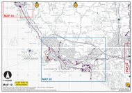
4.17 There is a strong north-west/south-east grain to the land<strong>for</strong>m of this character<br />
area evident in the pattern of valleys and hill ranges, such as the Crosbie Hills<br />
with their distinctive linear ‘wave’ pattern of peaks, and the upland plateau of<br />
more subtly rounded summits between the valley accommodating the<br />
Muirhead/Camphill Reservoirs and the Caaf valley. Kaim Hill (387m) <strong>for</strong>ms a<br />
distinct hill, particularly when seen from the west where its steep slopes back<br />
the coastal settlement of Fairlie. This character area is bounded by the A760<br />
to the north and the B781 to the south. A narrow road provides an elevated<br />
route within these uplands, aligned close to the naturalistic indented and<br />
scrub-fringed Caaf Reservoir which sits at the foot of the Crosbie Hills, be<strong>for</strong>e<br />
steeply descending to the coastal fringe. Angular <strong>for</strong>estry plantations, access<br />
tracks, transmission lines and the Wardlaw Wood wind farm (6 turbines,<br />
125m high) are located on the lower eastern hills of this area. The consented<br />
Kelburn wind farm of 14, 100m high turbines would extend wind farm<br />
development along a broad upland ridge north-east of Knockendon Reservoir.<br />
<strong>Landscape</strong> sensitivity<br />
4.18 All development typologies, if sited within or in close proximity to the Crosbie<br />
Hills, would significantly affect their distinctive land<strong>for</strong>m and the role they play<br />
in separating and partially containing the existing wind farm developments of<br />
Wardlaw Wood/Kelburn and the Ardrossan wind farm, which is sited within<br />
the adjacent ‘Haupland Muir’ landscape character area. The landscape<br />
setting provided to the ‘Raised Beach Coast’ by the steep slopes and rounded<br />
hill tops of the western most hills of this character area, the highest of these<br />
being Kaim Hill, would also be adversely affected by all typologies of wind<br />
farm development. The ridge between Blaeloch Hill and Cocklaw provides a<br />
rim of slightly higher ground on the northern edge of this character area and<br />
these peripheral hills are also important in providing a degree of containment<br />
to the existing wind farm developments of Wardlaw and Kelburn.<br />
4.19 All development typologies located within the lower Caaf valley would<br />
dominate the intimate scale and detract from the diverse character of the<br />
Caaf Reservoir. Smaller and single typologies (3, 4+6) sited anywhere within<br />
this character area would additionally unfavourably contrast with the scale of<br />
existing turbines.<br />
4.20 The existing Wardlaw wind farm is sited at the eastern end of a gently<br />
undulating upland area which appears as a broad ridge when viewed from<br />
Kaim Hill and from the A760. The consented Kelburn <strong>Wind</strong> farm which is<br />
located on this ‘ridge’ would emphasise the association of turbines with a<br />
particular land<strong>for</strong>m feature and would appear as a western extension to the<br />
constructed Wardlaw Wood development. A small extension (5) to the<br />
24