Landscape Capacity Study for Wind Farm ... - North Ayrshire Council
Landscape Capacity Study for Wind Farm ... - North Ayrshire Council
Landscape Capacity Study for Wind Farm ... - North Ayrshire Council

Create successful ePaper yourself
Turn your PDF publications into a flip-book with our unique Google optimized e-Paper software.
6.5 There is some limited capacity <strong>for</strong> development within the Duchal Moor<br />
landscape character area. In order to avoid intrusion on the adjacent<br />
character areas of Loch Thom and the Upland Core, it is likely that only<br />
smaller typologies (3+4) would be appropriate, providing these were located<br />
on lower slopes at the transition with the ‘Rugged Upland <strong>Farm</strong>land’ character<br />
area. Although views of wind farm development in this area would be likely to<br />
be restricted by higher ground, there would be impacts on views from the<br />
settled lowlands to the north-east and from nearby hill summits. This area lies<br />
beyond the boundaries of <strong>North</strong> <strong>Ayrshire</strong>.<br />
6.6 There was also found to be some limited capacity within the ‘Raised Beach<br />
Coast’ but only <strong>for</strong> small development typologies (4) located within the more<br />
modified parts of this character area. The need to avoid cumulative visual<br />
impacts with other tall structures was highlighted in the sensitivity<br />
assessment.<br />
6.7 The ‘Loch Thom’, ‘Upland Core’, ‘Intimate Pastoral Valley’, Haupland Muir’<br />
and ‘Rolling Hill Fringes’ landscape character areas were identified as having<br />
no capacity <strong>for</strong> wind farm development. This was due to the high sensitivity of<br />
the majority of key characteristics to all the development typologies<br />
considered in the assessment or, in the case of ‘Haupland Muir’, because<br />
capacity has already been reached due to the presence of existing wind farm<br />
development and landscape and visual constraints associated with remaining<br />
undeveloped land.<br />
A spatial strategy <strong>for</strong> development<br />
6.8 A strategy <strong>for</strong> directing future wind farm development to areas where<br />
landscape and visual impacts would be less significant and avoiding areas of<br />
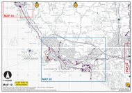
high sensitivity is recommended below. Figures 9 and 10 illustrate key<br />
constraints to wind farm development within the study area.<br />
Avoid wind farm development within the remote and undeveloped core<br />
of the uplands<br />
6.9 <strong>Wind</strong> farm development should be avoided within the central, slightly higher<br />
and open, undeveloped core of the uplands to conserve these qualities as a<br />
contrast to the remainder of the upland area, which is more modified, and a<br />
‘sanctuary’ <strong>for</strong> quiet recreation and the experience of wildness. This relatively<br />
intact upland landscape of rugged moorland is rare in the context of <strong>North</strong><br />
<strong>Ayrshire</strong> and is valuable in terms of its proximity to centres of population. This<br />
aim would also have the related advantages of retaining an intact skyline to<br />
this central and higher core of more defined hills seen from the Firth and<br />
islands to the west and from the lowlands of <strong>North</strong> <strong>Ayrshire</strong> to the east. It<br />
would also conserve the scenic landscape setting these hills provide to<br />
coastal settlement and the hill fringes to the east.<br />
41