Landscape Capacity Study for Wind Farm ... - North Ayrshire Council
Landscape Capacity Study for Wind Farm ... - North Ayrshire Council
Landscape Capacity Study for Wind Farm ... - North Ayrshire Council

Create successful ePaper yourself
Turn your PDF publications into a flip-book with our unique Google optimized e-Paper software.
existing Wardlaw Wood wind farm could potentially be accommodated on the<br />
less sensitive lower eastern uplands which are already characterised by<br />
turbine development and <strong>for</strong>estry. Medium to high sensitivity<br />
Perceptual qualities<br />
4.20 The presence of existing wind farm development (Wardlaw Wood and<br />
Kelburn), transmission lines, hill tracks and reservoirs reduces the perception<br />
of wildness and naturalness in this area. Additional wind farm development<br />
<strong>for</strong>ming an extension to the existing Wardlaw Wood wind farm (5) would be<br />
unlikely to have a noticeable effect on the perceptual qualities associated with<br />
this landscape character area. The location and increased elevation of Kaim<br />
Hill on the western periphery of this upland area provides an association with<br />
the wider landscape of the Firth of Clyde and islands. <strong>Wind</strong> farm development<br />
which encroached on the openness of Kaim hill would adversely affect the<br />
experience of walking in this area and diminish this association. Medium<br />
sensitivity<br />
Views and visibility<br />
4.21 This is not an extensive upland area and larger typologies (1+2) would be<br />
visible from the settled lowlands to the east and from the Firth of Clyde and<br />
islands to the west, although they would be seen in the context of existing<br />
wind farm development which reduces sensitivity. Developments sited on the<br />
western periphery of this character area would have a potentially far more<br />
significant effect in this respect and would also impact on views from the<br />
settled ‘Raised Beach Coast’ character area where the existing wind farm of<br />
Wardlaw Wood and consented wind farm of Kelburn are not widely visible at<br />
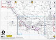
present. (This is demonstrated by Figure 7 which shows the relative<br />
prominence of the Kaim Hill wind farm proposal). <strong>Wind</strong>farm development<br />
located on the Crosbie Hills would be highly visible from the B781 and would<br />
breach the containment and separation they offer to existing windfarms.<br />
Similarly, turbines located on the slightly higher ridge of ground on the<br />
northern periphery of this character area between Cocklaw and Blaeloch Hill<br />
would dominate views from the A760 in the Muirhead and Camphill Reservoir<br />
area. The consented Kelburn windfarm will be partially visible from the A760<br />
development although the visual dominance of turbines will be restricted by<br />
views of only two turbine tips throughout much of this valley. Medium to high<br />
sensitivity<br />
Overall sensitivity<br />
4.22 The western peripheral hills, of which Kaim Hill is the most prominent, play a<br />
key role in providing the immediate backdrop and setting to the settled<br />
‘Raised Beach Coast’. The Crosbie Hills to the south are also important in<br />
separating and partially containing existing wind farm developments as is the<br />
slightly higher rim of ground between Cocklaw and Blaeloch Hill to the north.<br />
There is a need to retain the open and undeveloped character of these hills in<br />
order to protect adjacent character areas and views and to avoid significant<br />
25